
4.1 Designated heritage assets include:
4.2 The above are those buildings, monuments, sites, places, areas and landscapes that have statutory heritage significance and so merit special consideration in planning decisions.
4.3 Each of the 18 conservation areas in Hastings and St Leonards has a distinct character. In addition to seeking a high standard of development in conservation areas, the Council will also seek to preserve the distinctive character of the different areas of the town, by ensuring that new designs and materials are appropriate to the character of each of the specific conservation areas.
4.4 The Conservation Areas (their locations and extents are shown on the Polices Map):
4.5 Policy EN1 of the Planning Strategy describes how the Borough has a very rich and varied historic environment. The policy also outlines how there is a presumption in favour of the conservation of these assets and their setting. The policies of the Development Management Plan support Policy EN1 of the Planning Strategy by providing details about what is likely to be required in support of planning applications that have an impact upon heritage assets. This will ensure that we preserve the best of the historic and architectural legacy of Hastings and St Leonards, for future generations to enjoy. It is important that the potential impacts of any scheme are considered at an early stage by the applicant. This is especially important when considering the significance and setting of heritage assets. Full assessment of the significance of the heritage assets and consideration of the heritage impacts of various design options are a prerequisite of developing proposals that will have an acceptable impact on the historic environment. This evaluation process should be completed before detailed plans for a scheme are drawn up.
4.6 Listed building consent is required for proposed works in respect of listed buildings and scheduled monument consent for developments affecting scheduled monuments (both classed as heritage assets), and these regimes are not dealt with in this Local Plan4. The policies of this Plan are for guidance in judging applications for planning permission in relation to heritage assets. The policies do, though, deal with the impact of development on the setting of all heritage assets including conservation areas, listed buildings and scheduled monuments. According to national guidance, a key requirement of any proposal that may affect heritage assets is that the applicant demonstrates a detailed understanding of the significance of the heritage assets and also of the implications of their proposed development on both the heritage asset(s) and their setting.
4.7 The significance of a heritage asset is a measure of its cultural value to this and future generations because of its heritage interest. That interest may be archaeological, architectural, artistic or historic. Significance derives not only from a heritage asset's physical presence, but also from its setting. The impact that a proposed development might have on the historic environment will be better understood when the significance of any heritage assets affected has been identified. Once the significance is identified, it should then be easier to assess the likely implications of various design options on the elements that make up that significance. Appropriate design solutions or mitigation measures can then be included within a proposed scheme, to ensure that the significance of the heritage asset is sustained and enhanced through the development process.
4.8 Through the implementation of these policies, the Council will encourage applications for good quality and sensitive new development for these special places that will, over time, help to sustain and enhance their heritage value.
4.9 Applicants will need to demonstrate their understanding of the local character of the area of the Borough within which they hope to develop. This will include the impact of the local topography on views towards the development and the impact of their proposals on the setting of heritage assets.
4.10 The setting of a building may be provided by the other buildings and landscape that immediately surround it. However, in a hilly town, like Hastings, we must also consider that a new development some streets away, or across the other side of the valley, may also significantly affect the setting of a heritage asset.
4.11 A full assessment in the form of a Heritage Asset Statement, of the impact of the proposals (including changes of use), on all affected heritage assets will be required as part of the planning application submission. East Sussex County Council provides a service to help applicants complete Heritage Asset Statements. Further information is available directly from East Sussex County Council at: http://www.eastsussex.gov.uk/environment/archaeology/default.php
4.12 The County Council also has information about heritage assets including a Historic Environment Record (HER) that can be accessed and should be used to inform schemes that affect the significance and setting of heritage assets. Further information is available directly from East Sussex County Council at: http://www.eastsussex.gov.uk/environment/archaeology/default.php.
4.13 To view what is required in support of an application that may impact upon a heritage asset please see the validation check list available at: http://www.hastings.gov.uk/environment_planning/planning/info_advice/app_forms_guidance_notes/.
4.14 All applications put before the Council should demonstrate how they comply with Policy DM1 of this Development Management Plan (and where appropriate, those policies of the Planning Strategy that are referenced with Policy DM1, e.g. Policy SC3).
Policy HN1 – Development Affecting the Significance and Setting of Designated Heritage Assets (including Conservation Areas)
Applications that have the potential to impact upon the significance of designated heritage assets (including conservation areas) will be assessed against the following criteria, to ensure that the proposed development sustains and enhances the significance of the heritage asset:
Permission will be given for those schemes that show a full understanding of the significance of the asset and convincingly demonstrate how their chosen design sustains and enhances the significance of any heritage assets affected (including conservation areas).
The topography of Hastings means that the Council will give consideration to the impact of development on the setting of heritage assets, including the impact upon more distant views and from across the other sides of the valleys. The Council encourages proposals that sustain or enhance the setting of heritage assets.
Consideration will also be given to the impact of new development on the setting of the Hastings and St. Leonards seafront, almost all of which is covered by conservation area designation. This area currently enjoys relatively unimpeded long views, which are a key element of area character.
This policy is written for designated assets. However, non-designated heritage assets of archaeological interest that are demonstrably of equivalent significance to scheduled monuments (given the results of a Historic Environment Record informed study), will be treated as having at least the same level of significance as other designated heritage assets.
EN1: Built and Historic Environment
Changing doors, windows and roofs
4.15 There are circumstances where planning permission is required to change the doors, windows and/or roof of a property in a conservation area. The Council receives many applications that involve such proposals. Original timber sliding sash and casement windows, timber panel doors and roof materials can contribute greatly to the character and appearance of buildings within a conservation area, and so enhance its overall significance. However, sometimes these elements reach the end of their useful life, and require replacement. Under these circumstances, the Council will encourage the choice of replacement doors, windows or roofing material that retain the original character of the building.
4.16 Further Supplementary Planning Documents (SPD) that provide guidance for replacement doors and windows for listed buildings and conservation areas and roof materials for listed buildings and conservation areas are available on the Council's web pages: http://www.hastings.gov.uk/environment_planning/planning/localplan/spd/.
4.17 Shopfronts make an important contribution to the urban fabric
especially in conservation areas. Shopfronts have windows that have
evolved to fulfil the specialist function of enabling the shopkeeper
to display goods to potential customers. The town has many good quality
historic shopfronts, which contribute to the significance of historic
buildings and conservation areas. Guidance on making changes to shopfronts
is provided in the Council's Supplementary Planning Document (SPD) on
Shopfronts and Advertisements, which is available online at
http://www.hastings.gov.uk/environment_planning/planning/localplan/spd/.
4.18 Additional advice on making appropriate changes to windows in historic buildings can be found on the Historic England website https://www.historicengland.org.uk/
Policy HN2 – Changing Doors, Windows and Roofs in Conservation Areas
In conservation areas, the Council will seek to maintain the form and appearance of original windows, doors and roofs where this contributes to the character of the building and the significance of the wider conservation area.
To ensure properties are repaired and maintained to a good standard, planning permission will be given for new windows that reflect the traditional proportions, materials, finishes and opening arrangements of those that were originally fitted in the building. Slim section replacement windows may be acceptable on hidden facades, or where they closely match the design of the original windows and would not harm the character and appearance of the building or wider area.
Proposals for new windows and doors on elevations that are visible from public areas within conservation areas will be expected to be a close replica of the form and appearance of the original windows and doors. On visible elevations in conservation areas, planning permission will be given for new doors that reflect the traditional appearance, proportions, materials and finishes of the doors that were originally fitted in the building.
Permission will be given for replacement roof coverings where the material proposed is a close replica of the original roof covering in terms of materials, profile and gauge. Alternative roofing materials may be considered acceptable in the following circumstances:
EN1: Built and Historic Environment
4.19 Planning consent is required for a demolition that affects the significance or setting of a heritage asset, and this includes buildings and structures in a conservation area. In cases where the Council agrees to the demolition of a building in a conservation area, the case is often finely balanced, and the acceptance of the demolition relies on the quality of the building that is proposed as a replacement. If development does not follow demolition, then a loss to the overall significance of the conservation area may result. Also, the Council wishes to avoid situations where buildings are demolished in conservation areas and then the site sits vacant, potentially becoming a local eyesore and attractive to vandalism. It is therefore critical to ensure that the new development occurs within a reasonable interval, and to the required quality, after demolition has taken place.
Policy HN3 – Demolition involving Heritage Assets
Where planning permission is sought for a scheme that involves the demolition of all or part of a heritage asset (including buildings and structures within a conservation area), planning permission will only be granted where:
The Council will only grant planning permission for the demolition of a heritage asset in exceptional circumstances. Within conservation areas there may be buildings that have a negative impact upon the local character. The Council will encourage schemes that involve the demolition of these negative buildings if it can be demonstrated that their removal and the proposed replacement development enhances the conservation area in question.
The Council may seek to enter into an agreement, or impose a condition upon a decision, to ensure that demolition does not take place until a programme of works is agreed that ensures that development commences as soon as practical after demolition.
EN1: Built and Historic Environment
4.20 In a town with the historic significance of Hastings, archaeology is an important consideration. There are 6 scheduled monuments in the town and these are identified on the Policies Map. Separate scheduled monument consent is required for any work affecting a scheduled monument. In addition the Policies Map identifies various areas of the town recognised as being of particular archaeological importance. The National Planning Policy Framework (NPPF) also points out that heritage assets with archaeological interest are the primary source of evidence about the substance and evolution of places, and of the people and cultures that made them.
4.21 The Council will therefore seek to ensure that when a planning application is submitted, which affects a known archaeological asset or an area or building having archaeological potential, the archaeological importance of the site is suitably examined and evaluated. Where possible, the Council will encourage the preservation of significant archaeological remains in situ.
Policy HN4 – Development affecting Heritage Assets with Archaeological and Historic Interest or Potential Interest
For all applications affecting heritage assets with archaeological or historic interest or potential interest, the Council will require developers to submit an appropriate, Historic Environment Record (HER) informed, desk-based assessment and, where necessary, the results of a field evaluation. Applicants will be expected to demonstrate that the particular archaeological interest of the site will be satisfactorily preserved either in situ or by record.
EN1: Built and Historic Environment
4.22 Not all potential heritage assets are of a quality to be worthy of national level designation and protection. However, there are likely to be historic features within the Borough that have local heritage value, and so are worthy of consideration in making planning decisions. Such local heritage assets might include buildings or groups of buildings of high townscape value or distinctive local character, items of historic street furniture, and local historic parks and gardens etc. These are what we refer to as non-designated heritage assets. The Council has undertaken to compile a public record, or local list, of these local non-designated heritage assets, during the plan period.
4.23 The effect of a development on the significance of, or on the setting of, a non-designated heritage asset is a material consideration in the planning process. The weighting that can be given to the conservation of the heritage asset, within the assessment of the development proposals, will depend on the balance between the scale of harm or loss that will result from the development, and the significance of the asset.
Policy HN5 – Non-Designated Heritage Assets
Permission will be given for those developments that secure the preservation and enhancement of non-designated heritage assets and their settings. Schemes that show a positive commitment to retaining the asset, as an active part of the site will be encouraged.
Development that would result in the loss of, or demonstrably harm the significance or setting of a non- designated heritage asset, will be resisted, unless the proposed development has other public benefits that clearly outweigh the loss of, or harm to, the asset, or there is no other feasible means of bringing a key development site forward.
Where the loss of an asset cannot be avoided, it will be the responsibility of the developer to provide a fully documented and photographic record of the asset prior to its removal.
EN1: Built and Historic Environment
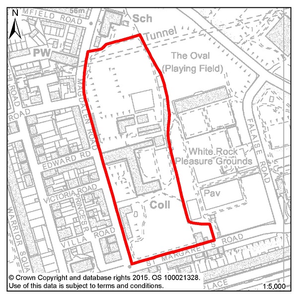
Figure 1: Former Convent of Holy Child Jesus, Magdalen Road
4.24 The 4.93ha site of the former Convent of Holy Child Jesus, Magdalen Road is a mostly vacant site that is sometimes used as a summer language school. The site includes a number of listed buildings, many of which are in need of repair. Allowing these buildings to become vacant and to deteriorate further represents a wasted resource. The Council wants to see as many as possible of the historically important buildings sympathetically converted and re-used. There may be a number of acceptable uses for the site; the key issue for the Council will be whether a specific proposal will be able to fund the repair and maintenance of the listed buildings.
4.25 In an established residential area, one option would be for the conversion of the listed buildings to residential use (with the exception of the Grade II* Chapel building, for which see below). Based on current information, the Council considers that the Priory, the Gothic Building, the Gate Lodge and the former Convent Building could be converted so as to provide approximately 32 dwellings.
4.26 Any development of this site will need to secure the restoration and long term future of the historic buildings. This will include the restoration and ongoing maintenance of the Grade II* listed Chapel building which is not capable of being converted but is a nationally important building.
4.27 As a last resort this could be achieved by means of enabling development. Enabling development is development that would be unacceptable in planning terms but for the fact that it would bring public benefits sufficient to justify it being carried out, and which could not otherwise be achieved. Enabling development is an established and useful planning tool by which a community may, after all other solutions have been explored, be able to secure the long term future of a place of heritage significance, and sometimes other public benefits, provided it is satisfied that the balance of public advantage lies in so doing. The public benefits are funded through the increased value of the land as a result of the grant of planning permission for its development.
4.28 In this case, because of the national importance of the site (a unique collection of Grade II* and Grade II listed buildings), 'community' and 'public interest' must be considered in the widest sense. The public gain would be the repair and conservation of the heritage assets for the long term and the amelioration of the harmful impact on the character and appearance of the area that is caused by the buildings' current poor condition. The dis-benefit would be the approval of built development that would otherwise be unacceptable in planning terms. Permission would only be granted if the public benefits can be shown to outweigh the harm of the scheme.
4.29 The following therefore, is an enabling development policy (a means of enabling restoration of the significance and setting of the heritage assets), not a specific site allocation for development.
Policy HN6 – Former Convent of Holy Child Jesus, Magdalen Road
Planning permission will not be granted for development within the curtilage of the Former Convent of the Holy Child Jesus unless it is enabling development which would secure the long term suitable use and future of the existing Listed Buildings.
Planning permission for enabling development will not be granted unless such development would:
The Local Planning Authority will liaise closely with Historic England on any scheme submitted including the sharing with them of any viability assessments or financial assessments submitted to support any development proposals.
In addition, planning permission will not be granted for enabling development unless:
4.30 These Listed buildings and their curtilage are a vitally important heritage asset in St Leonards and in the Borough as a whole. Their inclusion in a Conservation Area emphasises even more their historic and architectural importance. The Council is therefore keen to secure their suitable long term future which the provisions of Policy HN6 are designed to achieve. Enabling development is, however, undertaken as an exception to the usual planning policies which apply, and this justifies the rigour of Policy HN6. The Council will therefore work closely with the developer and monitor the implementation of an approved scheme, acting promptly if necessary to ensure that all conditions and obligations are met.
4.31 The Council is also mindful of the need to protect the setting of the nearby listed buildings and of the Conservation Area as a whole when considering any new development proposals for the site.
4.32 The general principles set out above will, where appropriate, be applied in the case of any other proposals for enabling development elsewhere in the Borough.
4.33 The Council will also take into account Historic England's adopted and emerging guidance on heritage assets and in particular advice on development in relation to heritage assets, protecting views and settings, available on the Historic England website at http://historicengland.org.uk/.
4.34 Through its pre-application service, the Council will provide informal guidance as to what constitutes enabling development in terms of the above policy. Where development proposals are not considered to be enabling development after consultation with the Council, such proposals will be assessed against other relevant policies in the Plan.
Policy:
EN1: Built and Historic Environment
4.35 The basis of the policy framework for protecting the natural environment is contained in the Planning Strategy, the majority of this is detailed in Chapter 7: Protecting our Environment but it also relates to Policy T3: Sustainable Transport and Policy CI2: Sports and Leisure Facilities. Where further detail is required, which is not included in the Planning Strategy, additional policies are provided here.
4.36 Planning Strategy Policy EN2 provides the framework for recognising and enhancing the green infrastructure network in Hastings, and requires new or enhanced green infrastructure to be incorporated into new development. A green infrastructure network is especially important in an urban area like Hastings to ensure natural areas are safeguarded and enhanced, and connections between these spaces are retained and improved where possible.
4.37 Green infrastructure can be incorporated into development in a wide variety of ways. The nature and scale of green infrastructure will depend on the type of development proposed and the existing character of the site and its surroundings. A range of green infrastructure should be explored in order to determine what is most appropriate for that particular site. A list of green infrastructure “functions” that need to be considered is listed in support of Policy EN2 of the Planning Strategy, although examples include:
4.38 Site allocations in the Development Management Plan seek to identify specific opportunities for enhancing green infrastructure where possible. Examples include new green space, or reserving land for cycle routes. The type of space needs to be appropriate to the surrounding area, yet offer a suitable variety of environments, fulfilling amenity, recreational, visual and ecological purposes.
4.39 Policy HN7 sets out the Council's general expectations for the inclusion, protection and enhancement of green infrastructure in development proposals. This policy will apply both to allocated sites and to any other sites which are brought forward during the course of the plan period.
4.40 The Council will require planning applications to include assessments
of existing ecology that are completed by a suitably and relevantly
qualified professional. These assessments should examine both on-site
ecology and the connectivity of the site with the green network, and
make provision for improvements where necessary both on and off site.
All habitats, including trees, hedges, shrubs and ponds should be identified,
together with opportunities for the retention or creation of green infrastructure.
The specific species of the proposed new planting should be given careful
consideration to avoid 'invasive species' and the loss of neighbouring
amenity. Measures for protection and management of the ecology will
also be required, where appropriate.
Policy HN7 – Green Infrastructure in New Developments
Where appropriate, good quality green infrastructure should be integrated into the design of new developments. Development will be permitted where opportunities for green infrastructure and landscaping have been incorporated into the proposals.
New green infrastructure provided as part of a development scheme should create safe links for the community and connectivity for biodiversity should be provided as far as practical, within the existing Green Infrastructure Network.
EN2: Green Infrastructure Network
EN3: Nature Conservation and Improvement of Biodiversity
T3: Sustainable Transport
CI2: Sports and Leisure Facilities
4.41 The Borough has numerous designated green spaces, ranging from international, to national, to local importance. Policy HN8 provides additional guidance for the environmental protection policies set out in Chapter 7 and also, Policy CI2 of the Planning Strategy, and Policy HN9 of this Plan. It is particularly important that proposals follow the approach set out in Policy EN3 of the Planning Strategy, in that they contribute positively to the natural environment by:
4.42 An Ecological Constraints and Opportunities Plan (ECOP) will be required to support relevant planning applications, and this will be specified in the validation checklist for planning applications. These assessments will also need to show a particular understanding of the impact of any potential development site on protected green areas in their locality, not just within the proposed development site. Importantly a scheme presented to the Council must reflect the findings of the Ecological Constraints and Opportunities Plan and appropriate design solutions should be incorporated.
4.43 To view what is required in support of an application that may impact upon environmental resources please see the “validation checklist” available at: http://www.hastings.gov.uk/environment_planning/planning/info_advice/app_forms_guidance_notes/.
Policy HN8 – Biodiversity and Green Space
Development should result in no net loss of biodiversity or designated green space as defined on the Policies Map. The weight given to the protection of sites will be proportionate to their position in the hierarchy of internationally, nationally and locally designated sites.
Development that would affect a designated site will only be permitted where there is an adverse impact on ecological, geological or biodiversity interests of the site if it can be demonstrated that;
An Ecological Constraints and Opportunities Plan (ECOP), completed by a suitably qualified professional, will be required to support planning applications where on-site or nearby ecological constraints are known, or where further information on potential ecological issues is required. This assessment should include:
EN2: Green Infrastructure Network
EN3: Nature Conservation and Improvement of Biodiversity
EN4: Ancient Woodland
EN5: Local Nature Reserves
EN6: Local Wildlife Sites
EN7: Conservation and Enhancement of Landscape
EN8: Open Spaces – Enhancement, Provision
and Protection
4.44 Of particular significance to Hastings is the nationally designated High Weald Area of Outstanding Natural Beauty (AONB), which covers 18% of the Borough. The AONB closely follows the Borough's administrative boundary to the north but to the east takes in the whole of Hastings Country Park and the Hastings Cliff Special Area of Conservation. Hastings Country Park represents the best coastal section of the AONB. The Council recognises the importance of protecting this nationally important landscape, and major development should not take place in the AONB save in exceptional circumstances as outlined at paragraphs 116 of the NPPF5
4.45 The Combe Haven Valley, in the west of the Borough, which includes the Combe Valley Countryside Park, is also recognised as a distinct landscape character area6 and here too it will be important to protect and enhance the existing landscape character of the area.
4.46 Any development that is proposed in the Combe Valley Countryside Park or High Weald will need to have regard to the potential impact to the landscape character. Development proposals within the AONB need to have regard to the purposes of the AONB designation, and will need to demonstrate how the proposal protects and enhances the landscape in accordance with NPPF policy. A landscape character assessment will be required to support relevant planning applications. Such assessments will also need to show an understanding of the impact of any potential development both within areas of landscape value and in their locality. Importantly a scheme presented to the Council must reflect the findings of the landscape assessment and appropriate design or mitigation measures should be incorporated.
Policy HN9 – Areas of Landscape Value
Areas of landscape value - Area of Outstanding Natural Beauty (AONB) and the Combe Valley Countryside Park, are displayed on the Policies Map. The inherent visual qualities and distinctive character of these areas will be protected. Development will only be permitted that is not detrimental to the character, scenic quality or visual benefit of these areas.
Where development proposals have the potential to impact an area of landscape value a landscape assessment will be required to understand the level of impact. Where impacts are identified proposals should incorporate the recommendations of this assessment.
EN2: Green Infrastructure Network
EN7: Conservation and Enhancement of Landscape
4.47 The Policies Map displays the boundaries of all of the protected green spaces in the Borough, both nationally and locally designated. These include Sites of Special Scientific Interest (SSSI), Special Areas of Conservation (SAC), Local Nature Reserves (LNR), Local Wildlife Sites (LWS), Ancient Woodland and more.
4.48 The Development Management Plan provides for the recognition and protection of three further locally identified sub-categories of open or green space – private open space, allotments and local green spaces. Their importance is primarily based on their social, recreational and appearance value, but these also have indirect biodiversity value and can act as a connection between other green spaces. These areas are also identified on the Policies Map.
4.49 There are some areas of green space in the Borough that are valued for their recreational role and the contribution they can make to the townscape of an area. Private open space can create breaks in the street scene and should be protected from development that would prejudice the open nature of such areas. Some local green spaces, such as allotments, are considered important in their local areas and make a valuable contribution to recreation and the areas character.
4.50 Allotments serve a number of purposes: They are a source of healthy food and they provide recreation for urban dwellers and they also support wildlife and biodiversity. There are presently 14 Council owned allotment sites in Hastings and one private site in Vale Road. All but one of the Council sites is directly managed, although the Council does encourage self-management. Waiting lists for allotments vary over time but at the time that the Plan was prepared they were at their lowest for a number of years. This is due in part to the Council creating additional plots through sub-division and bringing back uncultivated land into use. There are no plans to create additional allotment sites. The Council will however seek to retain existing sites in allotment use.
4.51 The Council will protect these areas for the community for their amenity value and also because they contribute to the green infrastructure network.
Policy HN10 – Amenity Green Spaces
The Council will protect Private Open Space, Allotments and Local Green Spaces used and/or managed by the local community, as identified on the Policies Map. Planning permission will only be granted for development which would result in the loss of an identified amenity green space in the following circumstances:
EN2: Green Infrastructure Network
EN8: Open Spaces – Enhancement, Provision
and Protection
5.1 To protect the viability of shopping and other commercial activities and the mix of shops and services on offer, and to balance the aspirations and needs of local communities, the Local Plan provides policy guidance on what land uses will be permitted in the shopping areas defined in the Policies Map.
5.2 Some of the larger shopping areas provide a range of facilities, including not only shops and banks but also GP surgeries and dentists. These help to reduce the need for people in the neighbourhood to make long distance journeys. These centres are focal points in the local neighbourhood and are also accessible to less mobile members of the community, thus aiding social inclusion.
5.3 Shopping areas are also of great importance to the provision of employment opportunities and services. There is potential to add to the number of people using the shops and services in the centres, and, for these reasons, there is a need to protect the land uses in these areas so they remain predominantly in retail and business use.
5.4 The defined shopping areas are listed below (these follow the shopping hierarchy set out in Policy E3 of the Planning Strategy and are in general support of the other policies of Chapter 9):
Town Centre - |
Hastings Town Centre |
District Centre - |
St Leonards Centre |
Local Centre - |
Bohemia |
Neighbourhood Centre - |
Battle Road |
5.5 Other activities that take place in and around the identified shopping areas can help to add to the vitality and vibrancy of them. Markets can be a good way for businesses to develop or for customers to discover new things. They can also help foster community spirit and create an identity for an area. A licence for street trading is required for anyone wishing to run a market stall and this can be obtained, provided that information about the times of sale, the types of things for sale and proof of insurance are submitted to the Council. For more information on this please see our web pages at http://www.hastings.gov.uk/environment_planning/licensing/licensable_activities_forms/#street_trading.
5.6 The Council will continue to encourage and support well managed street markets such as those that have proved successful in Hastings Town Centre, The Stade and Kings Road in St Leonards.
5.7 There is a clear desire to ensure that Hastings Town Centre retains and strengthens its retail offer. A strong retail presence is essential if the town centre is to compete effectively with other nearby shopping destinations, including Eastbourne and Royal Tunbridge Wells, and to remain a sub-regional centre within the South East.
5.8 Recent national guidance also suggests that identifying core (or primary) areas of retail and secondary areas of niche shops, cafés and restaurants is important. This can help to maintain the vitality of town centres and the appropriate mix of services on offer within them.
5.9 The retail offer in Hastings Town Centre is characterised by a mix of larger national multiple retailers and smaller independent and specialist retailers. The primary retail core of the town centre, which is identified on the Policies Map, is focused around Priory Meadow. The adjoining pedestrianised streets of Queens Road, Robertson Street, Wellington Place and further to the north along Queens Road as far as the Morrisons food store contain national retailers, large and small shops and other services. There are also important areas of specialist and independent shops on Trinity Street, Claremont and the non-pedestrianised section of Robertson Street extending into White Rock.
5.10 It is recognised that different and complementary uses during the day and in the evening can reinforce each other, making the town centre more attractive to local residents, shoppers, workers and visitors. Helping to maintain and enhance the vibrancy and vitality of Hastings Town Centre will be the continued encouragement of appropriate residential development above premises in the identified areas. These factors have been taken into consideration when setting the threshold levels for non-A1 use classes in the primary retail areas.
5.11 Retail uses should continue to dominate the primary retail core. Policy SA1 will be applied when assessing applications for the change of use from an A1 retail unit to another use.
5.12 Priory Meadow is a pedestrianised shopping centre located in the central part of the primary retail core. This is the prime retail location within the shopping area, catering for mainstream comparison shopping and accommodating the majority of the Town's multiple stores. Pedestrian flows are high and vacancy levels are low indicating the retail supremacy of the area. This area is a primary attraction to shoppers visiting Hastings Town Centre. The retail function should continue to predominate strongly here. There is a planning condition that states that non-A1 uses should not exceed 1,400m2 of the total floorspace of Priory Meadow.
5.13 This part of the primary shopping area is characterised by a mixed retail presence including national multiples, independent traders in smaller units and a number of specialist stores. Again pedestrian flows are high here with excellent linkages to the railway station, bus routes and access to multi-storey car parking at Priory Meadow and Priory Street. The seafront car parks also serve this shopping area. Restricting non-A1 to 45% of the total number of ground floor units would allow scope for a range of uses within this primary retail core area without damaging the current function of the area.
5.14 The following factors will be taken into account in the implementation of Policy SA1:
a) The size of retail units
Within the Town Centre, retail units and frontages vary in both size and character. For example, a retail unit with a greater frontage generally has a more significant impact on the street scene. It is therefore appropriate to consider the scale of the unit subject to development.
b) The concentration of non-retail units
In general, a number of non-A1units adjacent to each other in the shopping frontage on one side of the road could constitute a high concentration and therefore a significant interruption. However, this would depend also on the scale and location of the units in question and the types of use proposed. For example, a number of class A3 (Restaurants and café) units within the shopping frontage may add character and life to a shopping frontage, whereas a class C3 (Dwelling Houses) use would not add to the attractiveness to shoppers of the shopping area. The Council will therefore consider each case on its individual merits, having regard to the existing situation and the use proposed.
5.15 When determining planning applications seeking a change of use away from A1, within Hastings Town Centre Shopping Area, the current percentage position between Planning Use Class A1 and non-A1 uses will be calculated ignoring floorspace/units in a temporary flexible use. Only the permanent lawful use of the floorspace/unit will form part of the calculation.
Policy SA1 – Hastings Town Centre Shopping Area
Within Hastings Town Centre Shopping Area, as defined on the Policies Map, at ground floor level, proposals for planning use-class A1, A2, A3, A4 and other uses appropriate to the character of the shopping area will be permitted provided both of the following criteria are satisfied:
E3:Town, District and Local Centres
5.16 It is important to assist the smaller centres in the town. They provide convenient district, local and neighbourhood level facilities as well as in some cases, being valuable for specialist services.
5.17 In order to protect the role of these centres within the shopping hierarchy, in line with Planning Strategy Policy E3, the Council will seek to ensure that the key retail areas indicated on the Policies Map are retained for predominantly class A1 uses (shops). Planning applications for non-A1 uses may be permitted in these areas, but only provided that they would not either individually, or cumulatively with other recently completed developments and outstanding planning permissions, be likely to undermine the primary retail function of these areas. Appropriate residential development above premises within these areas will be welcomed to help maintain and enhance the vibrancy and vitality of them.
5.18 St Leonards serves a broader function than the other district centres. Though smaller, it is similar in character to Hastings Town Centre, and includes a broad range of retailers within the centre, comprising a mix of national multiples, independent traders and specialist traders, along with a number of banks, building societies, restaurants and cafés.
5.19 The Primary retail area of St Leonards includes the whole of King's Road, the lower part of London Road, and the eastern part of Norman Road. It is important that a vibrant and varied mix of town centre retail uses remain predominant in this area.
5.20 The areas of Silchester Road, the eastern part of Grand Parade, the upper part of London Road (number 45 upwards) and the western part of Norman Road contain varying levels of retail activity, but are interspersed with commercial and residential uses. These areas are therefore considered to be secondary retail areas. Whilst it is still important to ensure that the overall vitality and viability of these areas is not diminished, a greater degree of flexibility will be applied to allowing non-retail uses including banks, building societies (class A2), cafes and restaurants (class A3), pubs and bars (class A4) and small commercial office space (class B1(a) office).
5.21 The main speciality centre in the Borough is the Old Town with its craft and antique shops and restaurants.
5.22 Silverhill and Ore are the other two district centres. They rely on a good range of local convenience stores and, in particular, the presence of supermarkets. Both centres have a Post Office, high street banks and building societies, and a range of professional services. At Silverhill, the core shopping area has now been extended and reinforced by the opening of a large scale supermarket.
5.23 Bohemia local centre comprises primarily independent retailers but with a limited number of national retailers. There is a range of professional services including estate agents and solicitors.
5.24 Neighbourhood Shopping Areas, as indicated on the Policies Map, cater primarily for the day to day needs of the nearby area or those passing by, but may also cater for more limited specialist needs from a wider area. They are more easily accessible to the local community, in particular the elderly and less mobile. The role of Local and Neighbourhood Shopping Areas has been somewhat eroded in recent times with the increased preference for large food stores and increased car use, but the Council intends to do what it can to support the survival of these important community assets.
5.25 The neighbourhood shopping areas at West St Leonards (Bexhill Road), Battle Road, Mount Pleasant, Mount Road and Marine Court include a more limited range of stores, for example newsagents/confectioners, chemist, post office, grocers/mini-market, baker and butcher, serving their immediate neighbourhoods. These centres range in size and character from the small groups of shops at Mount Pleasant to the more specialist shops at Marine Court.
5.26 When determining planning applications seeking a change of use away from A1, within a defined shopping area, the current percentage position between Planning Use Class A1 and non-A1 uses will be calculated ignoring units in a temporary flexible use. Only the permanent lawful use of the unit will form part of the calculation.
5.27 The following factors will be taken account in the implementation of Policy SA2:
a) The size of retail units
Retail units and retail frontages vary in both size and character. For example, a retail unit with a greater frontage generally has a more significant impact on the street scene. It is therefore appropriate to consider the scale of the unit subject to development.
b) The concentration of non-retail units
In general, a number of non-A1 units adjacent to each other in the shopping frontage on one side of the road could constitute a high concentration and therefore a significant interruption. However, this would depend also on the scale and location of the units in question and the types of use proposed. For example, a number of class A3 (Restaurants and café) units may add character and life to a retail frontage, whereas, a class C3 (Dwelling Houses), use would not add to the attractiveness of the shopping area. The Council will therefore consider each case on its individual merits, having regard to the existing situation and the use proposed.
Policy SA2 – Other Shopping Areas
Within district, local and neighbourhood Primary Shopping Areas, as defined on the Policies Map, at ground floor level, proposals for Class A1, A2, A3, A4, A5 and other uses appropriate to the character of the shopping area will be permitted provided both of the following criteria are satisfied:
St Leonards Centre |
Primary area |
40% |
|
Secondary area |
60% |
The Old Town |
|
45% |
Ore Village |
|
45% |
Silverhill |
|
45% |
Bohemia |
|
50% |
Battle Road |
|
50% |
Mount Pleasant |
|
40% |
Mount Road |
|
40% |
Marine Court |
|
40% |
West St Leonards (Bexhill Road) |
|
40% |
E3: Town, District and Local Centres
5.28 Some local shops and services provide a particularly important focal point for a community. The corner shop or doctors surgery that is outside of the main shopping areas, as shown on the Policies Maps, is potentially more accessible, especially for those without private transport, and the Council believes that these should be afforded some protection.
5.29 Policy SC1 of the Planning Strategy details how a sustainable community could be achieved and an important part of this is access to shops and services. This access is for existing services or for goods that are required on a daily basis and can most often be found in local convenience shops.
5.30 Policy SA3 is intended for those shops and services that generally have a small catchment area and whose customers and visitors are less likely to arrive by car.
5.31 It is, however, acknowledged that where it can be demonstrated that the shop or service is not economically viable (this will be determined on a case by case basis), and has been tested through marketing, it may be unreasonable to refuse a change of use.
Policy SA3 – Shops and Services outside the Shopping Areas
Proposals for the change of use or redevelopment that would result in the loss of a local shop or service outside the defined commercial areas will only be permitted when:
SC1: Overall Strategy for Managing Change in a Sustainable Way
E3: Town, District and Local Centres
5.32 There may be a need to manage the concentration of shops and services outside defined shopping areas, and also the concentration of single types of outlet to reduce, for example, noise or litter production. Policy DM3 of this plan details what should be considered, in terms of amenity, by proposers of schemes. In the cases of proposals for drinking establishments (A4 in the Planning Use Class Order) and hot food take-aways (use class A5), the Council believes some extra assessment of the likely impacts will be required. The nature of these assessments and additional information are outlined in Policy SA4.
5.33 Certain types of retail activity have a greater effect on their neighbours; this could be because of what they sell or the hours that they open. The particular nature of alcohol and (hot food) take-away sales means that people use the premises that sell them in a different way to other shops and restaurants.
5.34 Proposals that involve drinking establishments and (hot food) take-aways should include careful consideration of the ways that people are going to use the premises. This will include how they will access the premises, whether there is enough parking, and at what times customers are likely to use them. All of these will affect both immediate neighbours and those living in the local vicinity, and should be carefully assessed.
Policy SA4 – Drinking Establishments and Hot Food Take-Aways
Planning permission for new drinking establishments (use class A4 of the Town and Country Planning Use Classes Order 1987 (as amended)) and hot food take-aways (use class A5) will be granted provided that:
SC1: Overall Strategy for Managing Change in
a Sustainable Way
E3: Town, District and Local Centres
5.35 Caravan and camping sites contribute in an important way to tourism. Planning Strategy Policy E4 demonstrates the Council's commitment to secure sustainable tourism development in the town. As most of the towns existing caravan and camping pitches adjoin the High Weald Area of Outstanding Natural Beauty and other significant environmental designations, it is important any proposals for expansion are sensitive to the impact on the countryside, particularly in terms of preserving and enhancing the landscape and avoiding any adverse impact.
5.36 The Local Plan does not include a specific policy criterion requiring
the use of caravan, camping and chalets sites on a seasonal basis only.
However, assurance that the premises shall not be occupied as a person's
sole or main place of residence will be dealt with by condition of the
planning permission.
Policy CC1 – Caravan, Camping and Chalet sites
Planning permission will be granted for additional caravan and camping sites or the expansion of existing sites provided the proposal:
Proposals for the intensification (increase in pitch number within the existing permitted area), the reorganisation of uses/layout (within the existing site) and the enhancement of site facilities/provision of new facilities in connection with existing sites for tents, touring caravans, static caravans and chalets will be permitted provided the proposal:
EN3: Nature Conservation and Improvement of
Biodiversity
EN7: Conservation and Enhancement of Landscape
E4: Tourism and Visitors
5.37 The policy which follows is derived directly from objectives set out in the Hastings Cultural Regeneration Strategy 2010-2015 and also confirmed in the Hastings Planning Strategy.
5.38 It is widely recognised that cultural activities can make a vital contribution to a local economy including the creative sector, increasing employment and skill levels and empowering residents and communities. By supporting cultural activity, we can strengthen our visitor economy and raise aspirations in the Town. In addition, the NPPF recognises the importance of the cultural well-being of the community in planning for sustainable development.
5.39 Hastings has a strong and diverse cultural infrastructure including a number of important components - most recently, the Jerwood Gallery and Stade performance space but also: performance venues; museums; art galleries and studios; the cultural dimension offered by Sussex Coast College and the University of Brighton Hastings campus; the Creative Media Centre; the potential that could come from the restoration of Hastings Pier and most importantly, its artists, performers and other creative businesses and communities and its tradition of festivals.
5.40 Cultural activities include: visual and performing arts, media, architecture and design, heritage and historic environment, libraries and literature, museums and galleries, education and cultural related tourism. However, a range of other activities is associated with them and provide necessary support, for example: hospitality, specialist retail, food and drink, workshops, and community led activities.
5.41 It is natural for many of these to cluster within an area for mutual advantage. Such areas are often characterised by mixed uses, diversity, and small scale activities such as workshops, live-work premises and café culture. They need to embrace flexibility, change and temporary uses to engender an environment which is creative and vital in nature. They can also benefit if there is an availability of indoor and outdoor exhibition and performance space. Supporting and nurturing such areas is important if they are to thrive.
5.42 In Hastings, four such areas have been identified and planning policy will seek to support their role and a secure future for them. The areas are:
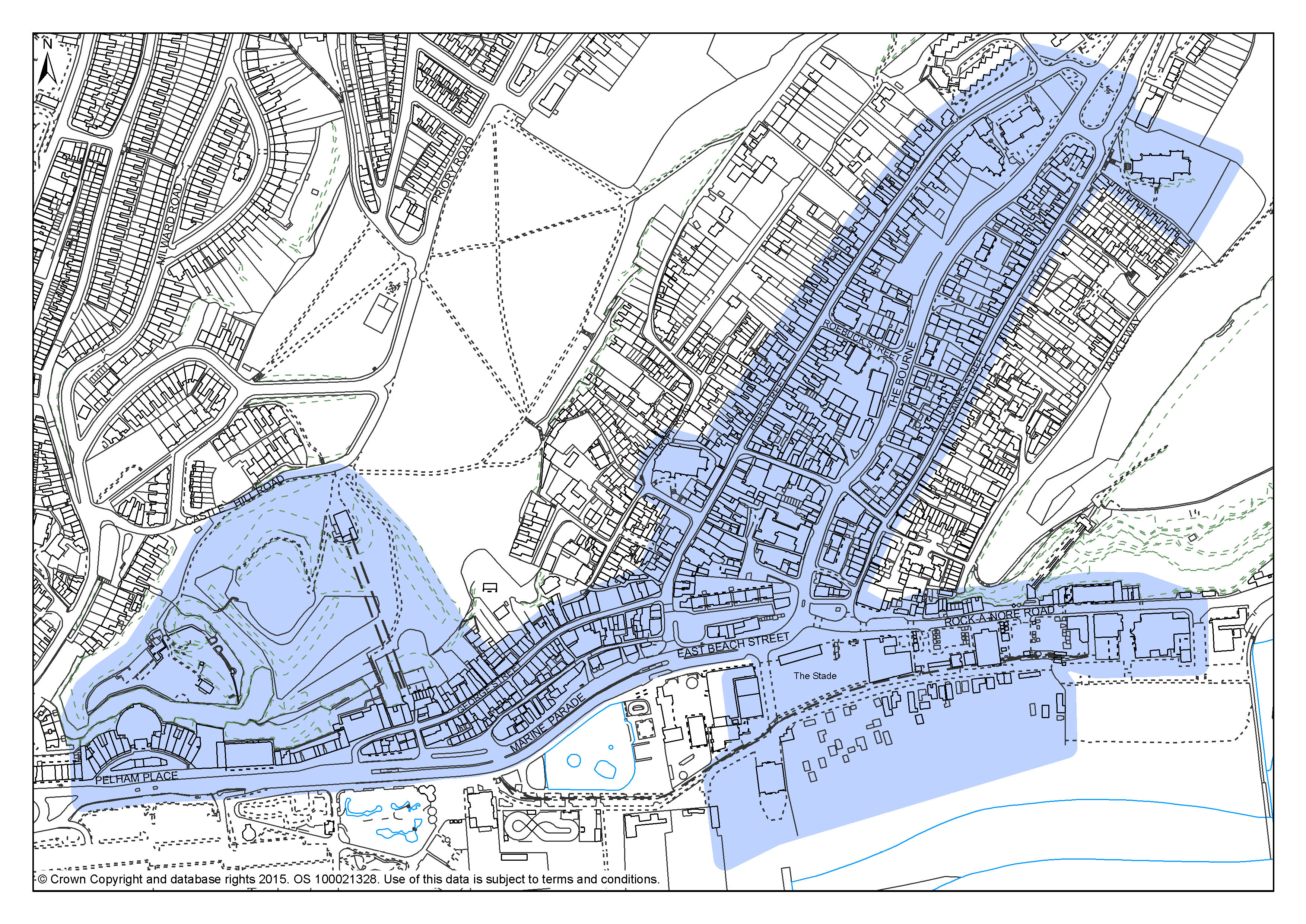
5.43 Old Town and The Stade – The Old Town has long been the focus for a wide range of cultural activity helped by its distinctive non-conformist image – ranging from Old Town Week, to crafts, to performance art. The introduction of the Jerwood Gallery and The Stade performance space linked to the strong heritage of the fishermen's beach and museum is a new facet for the area. The St Mary in the Castle area is also included.
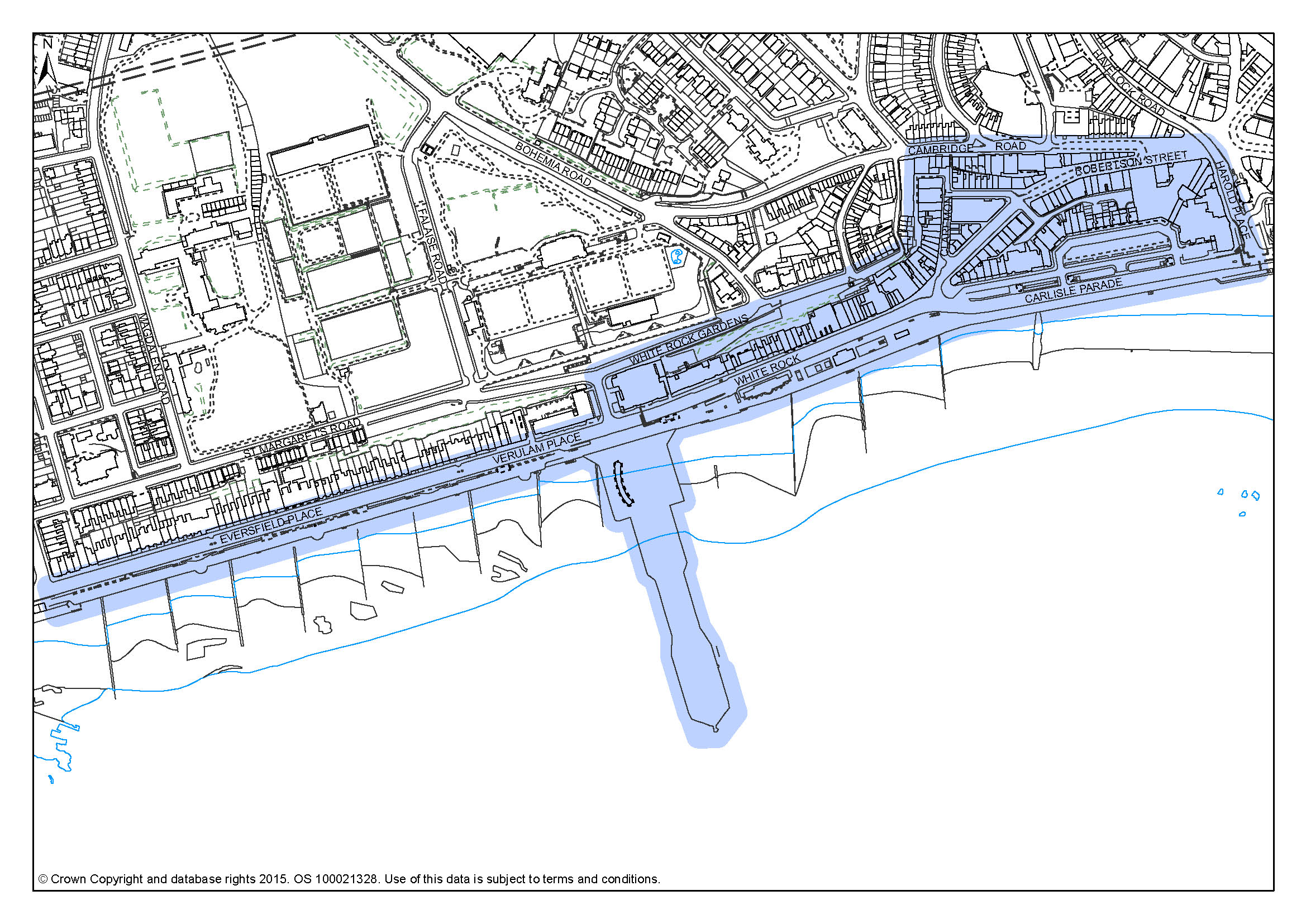
5.44 White Rock and the America Ground – The cluster of the theatre, the hotel, the pier and the opportunities of the White Rock Baths site and Bottle Alley defines the western end of this area which extends eastwards along the seafront to the America Ground area with the library, the Creative Media Centre and its collection of restaurants and cafés.
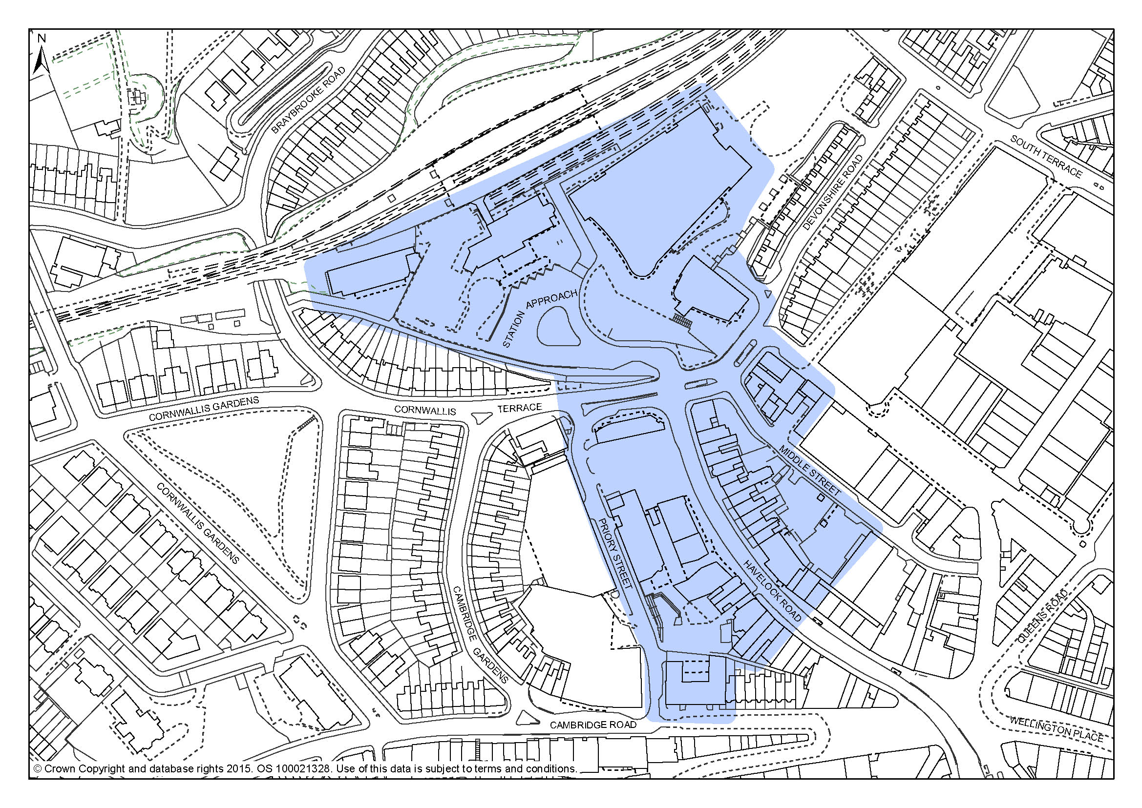
5.45 Academic – The core of this area is Sussex Coast College and the two University of Brighton's Hastings campus buildings and the cultural activity generated within them. Complementary activities such as shops and cafés are beginning to establish and could be encouraged further.
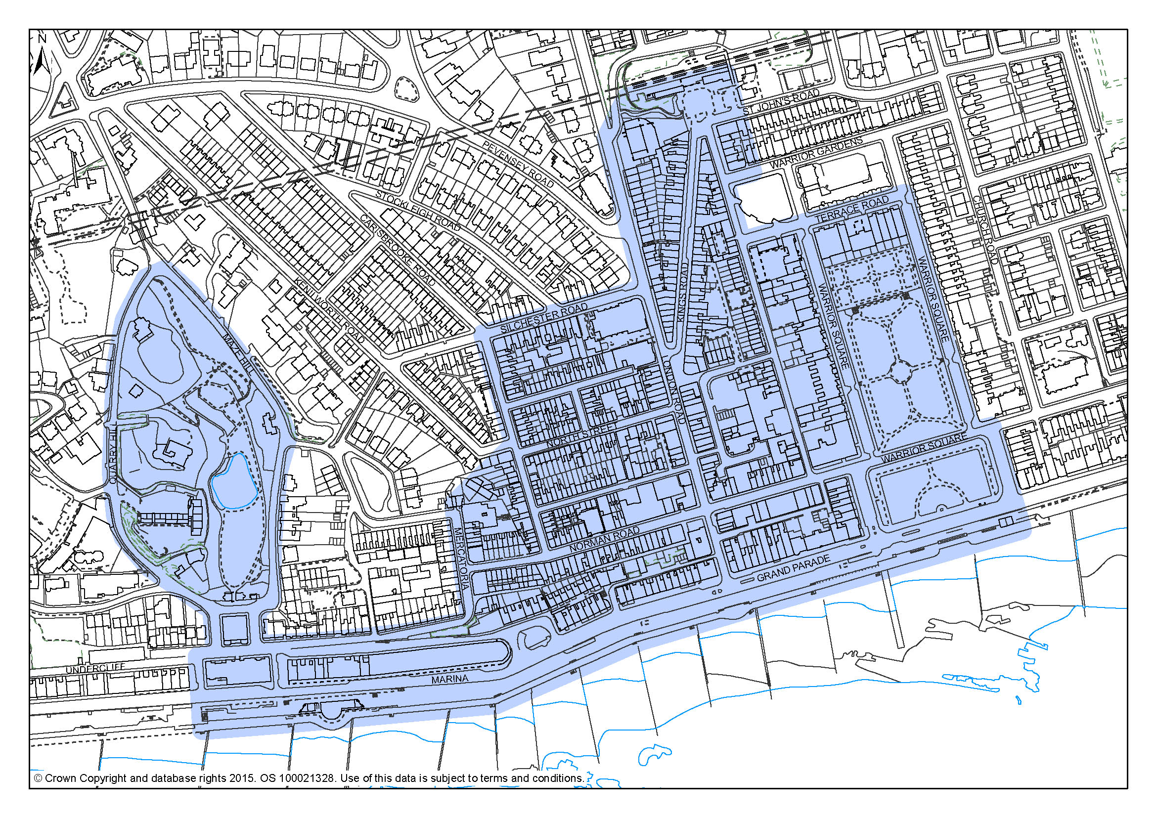
5.46 Central St Leonards and The Seafront – A range of cultural activities are spread throughout this centre, including art and craft shops, small galleries and community facilities including the Magnet Centre. St Leonards Gardens and Warrior Square are used for performance and cultural events, and there are small sites suitable for cultural projects. The area has been the subject of a regeneration programme over a number of years and it is becoming a favoured place for artists to locate to.
5.47 To support this policy, where opportunities arise and subject to available resources, the Council will take steps to enhance positive qualities of the built environment and the public realm within the Cultural Quarters.
Policy CQ1 – Cultural Quarters
The Council recognises the importance of cultural activities within Hastings, to the local economy and the well-being and enjoyment of the community at large and to visitors.
Four Cultural Quarters have been identified where such activities are concentrated, and where their continuance and expansion will be encouraged and supported:
The areas displayed on the next pages, are indicative of where the identified activities take place and should be seen as a guide and not necessarily a boundary.
Within these areas:
The Council will exercise this planning policy in a way that does not compromise its adopted Licensing Policy. The Licensing Policy is designed to guide the licensing of the sale of alcohol, clubs and regulated entertainment.
FA3: Strategy for Hastings Town Centre
FA4: Strategy for Central St Leonards
© Crown Copyright and database rights [2015]. OS [100021328]. Use of this data is subject to terms and conditions.
Figure 2: Old Town and The Stade Cultural Quarter
© Crown Copyright and database rights [2015]. OS [100021328]. Use of this data is subject to terms and conditions.
Figure 3: White Rock and the America Ground Cultural Quarter
© Crown Copyright and database rights [2015]. OS [100021328]. Use of this data is subject to terms and conditions.
Figure 4: Academic Cultural Quarter
© Crown Copyright and database rights [2015]. OS [100021328]. Use of this data is subject to terms and conditions.
Figure 5: Central St Leonards Cultural Quarter
4 For more information see: http://www.hastings.gov.uk/environment_planning/planning/info_advice/pre_app_advice/#listed
5 https://www.gov.uk/government/uploads/system/uploads/attachment_data/file/6077/2116950.pdf
6 As set out in the East Sussex County Council's Landscape Character Assessment available at http://www.eastsussex.gov.uk/environment/landscape/download.php
< Previous | ^ Top | Next >