
© Crown Copyright and database rights [2015]. OS [100021328]. Use of this data is subject to terms and conditions.
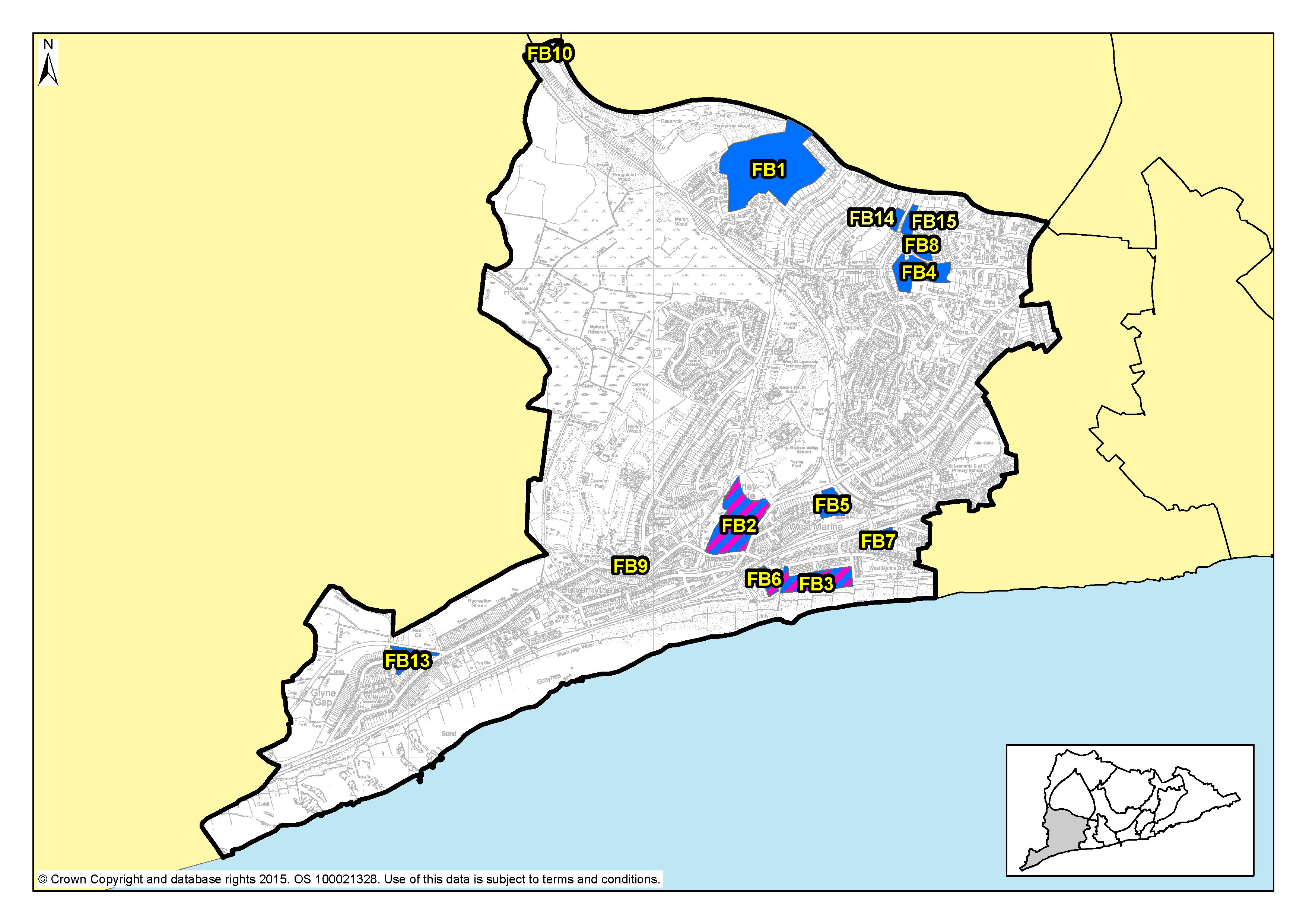
Figure 29: Focus Area 3 – Filsham Valley & Bulverhythe
6.74 Extending from West Marina in the east and Queensway in the north, to the western boundaries of the Borough, this is an area of contrast between 20th Century housing, commercial depots, and wetland nature reserves. When travelling by train from London, this is where visitors get their first impression of Hastings & St Leonards as they glimpse the sea across school playing fields and open spaces that follow the valley to the coast at Bulverhythe.
6.75 The coastal strip was the first part to be developed, along Bexhill Road. Around West Marina Gardens, housing is Victorian and Edwardian, where some of the former grandeur has faded. Recent years have seen a revival however, with much of this housing renovated. Further west, the old bathing pool site remains a development opportunity, alongside the beach chalets here and those at West Haven further along. Beyond this, the housing along Bexhill Road is generally that which was built between the wars. There are industrial areas here too and Brownfield development sites, such as the old West St Leonards school.
6.76 Inland, the housing is more modern, built mostly from the 1930s through to the late 20th Century, the most recent development on a former golf course. East of the Hastings Line railway, the houses are older, larger and mostly detached. This part of the area has a different feel; quieter, more peaceful, an urban fringe with leafy suburban streets in the east to nature reserves to the west, and surrounding countryside. The creation of the St Leonards Academy on the old Filsham Valley school site provides the potential to open the Grove School site as another development opportunity in Filsham Valley & Bulverhythe.
6.77 There are shops scattered through Filsham Valley & Bulverhythe, cafés and takeaways, several larger retail warehouses, a garden centre, car dealers, assorted other commercial premises, and a small community centre. This Focus Area also contains the West St Leonards railway station on the Hastings Line between Ashford in the east and London to the north.
6.78 The beach and coastline here is relatively isolated. Access to it is challenging because it is cut off from the town by the Hastings to Brighton railway line, and to some extent the A259 Bexhill Road. North of Bexhill Road, there are two important wetland nature reserves: South Saxon wetlands and Filsham Reedbeds, within the Combe Haven Site of Special Scientific Interest (SSSI). There are playing fields too, and the Combe Haven holiday park, an important source of tourist accommodation.
6.79 According to 2001 Census data, 8,500 people live here and almost 50% of them are over the age of 45; this is higher than the Borough average. It is the third least deprived Focus Area of the 13 (Office of National Statistics). Census data also shows that 80% of the housing in this Focus Area is owner- occupied. The A259, Bexhill Road, dominates the southern part of the Filsham Valley & Bulverhythe Focus Area, but with the completion of the Bexhill-Hastings Link Road and the route options for journeys that this will bring, the congestion along this road should be reduced. Public transport options are good, and the recently completed cycle route along the seafront has created another way for people to reach Bexhill and the beach, so connectivity in this Focus Area is generally good and access to the coastline and beach is improving.
6.80 Of all the Focus Areas in the Borough, Filsham Valley & Bulverhythe has the potential to see the most change. There are some larger brownfield development opportunity sites here, which could be developed as housing. Policy FA1 of the Planning Strategy identifies that this area has the potential capacity for between 630-700 additional homes up to 2028. With some of the largest sites in the Borough available here, we would expect to see some innovative and imaginative uses of the land. Higher densities may well be possible, if suitably achieved with perhaps limited flatted developments. But there is a need to retain employment sites, so some existing commercial premises should be kept for employment purposes and their quality and use maintained or improved where possible.
6.81 However, the area is low-lying and parts of it are in a designated flood risk area. Flood risk, and getting adequate drainage in place, is a significant challenge here.
6.82 When the Bexhill-Hastings Link Road is built, this will make a big difference to Bulverhythe & Filsham Valley, both along Bexhill Road and along Filsham Road. Together with the new cycle path, we would expect to see more people using the beach and sea, and tourists attracted to this area. So there is likely to be the opportunity for more facilities for them close to the beach access points: cafés, small shops, sports, and possibly licensed premises. Consideration may be given to proposals for cafés on the beach side of the railway line. We want this part of the area to come to life, to shake off it's 'edgelands' feel and reinvent itself. Innovation and imagination offer the potential to help maintain and strengthen the economy and community in this part of the Borough.
6.83 The former bathing pool site at West Marina remains one of the most prominent development sites on Hastings' seafront. During the next 15 years, we expect this to be developed for both homes and leisure use. Because the site is prominent, potential schemes here would need to pay particular attention to good design and innovation, perhaps something that would be a tourist destination in itself. However, we recognise that it may be a while before such a development is viable, so innovative temporary uses for the site would be encouraged in the meantime.
6.84 The SSSI along Combe Valley will remain protected from development, beyond improved visitor facilities, although these would need to be restrained and environmentally sustainable. And we would want to retain important tourist accommodation at Combe Haven Holiday Park. Public playing fields and allotments elsewhere in the area will also continue to be protected.
| Site reference | Address | Allocation (including potential number of homes) | Area (ha) | Does the site have a brief in section 5? |
| FB1 | The Grove School | Residential (240) | 9.40 | ✔ |
| FB2 | Former West St Leonards Primary School | Mixed use (100) | 3.92 | ✔ |
| FB3 | Seaside Road, West St Leonards | Mixed use (120) | 2.22 | ✔ |
| FB4 | Former Westerleigh School | Residential (68) | 2.15 | ✔ |
| FB5 | Former Hastings College, St Saviours Road | Residential (44) | 1.05 | ✖ |
| FB6 | Cinque Ports Way (Former Stamco Timber Yard and TA Centre) | Mixed use (25) | 0.65 | ✔ |
| FB7 | 123-125 West Hill Road (Former Malmesbury House) | Residential (117) | 0.70 | ✖ |
| FB8 | Former Westerleigh School Playing Fields | Residential (7) | 0.56 | ✖ |
| FB9 | 190 Bexhill Road | Residential (32) | 0.19 | ✖ |
| FB10 | Land south of Crowhurst Road | Permanent site for Gypsies and Travellers (2 pitches) | 0.17 | ✖ |
| FB13 | Hastings Garden Centre, Bexhill Road | Residential (12) | 0.78 | ✖ |
| FB14 | Land north of 31 Fern Road | Residential (10) | 0.28 | ✖ |
| FB15 | Land north of 14 Fern Road | Residential (14) | 0.46 | ✖ |
Table 5: Residential, mixed use and other allocations for Filsham Valley & Bulverhythe
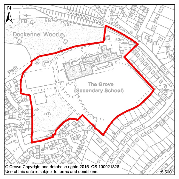
Figure 30: FB1 –The Grove School
Site address: The Grove School
Allocated use: Residential
Area: 9.40ha
Possible net capacity: 240
6.85 Site FB1 – The Grove School has become available for development as it is now considered to be surplus to requirements. The majority of the wooded area in the south-west of the site should be retained and not form part of any redevelopment. A density of 30 dwellings per hectare is assumed and therefore the site could be capable of delivering about 240 units.
6.86 This is a large and relatively level site, in an existing residential area. Its size and location will be expected to support a varied housing mix; to include affordable houses and specific housing for wheelchair users. There is a Multi-Use Games Area on site and it retention or relocation must be included in the development proposals.
6.87 Dogkennel Wood to the north-west of the site is an area of Ancient Woodland and this should be conserved, as should existing public footpaths around the site. East Sussex County Council's highway department has commented that the development will require highway junction improvements. The capacity potential of this site indicates that a Transport Assessment and Travel Plan will also be required. Wishing Tree Lane adjacent to the eastern boundary of the site is a privately owned road, if any proposals are to include this road as an access point agreements will have to be made with its owners. Further advice on transport matters is available from East Sussex County Council.
6.88 There are areas of surface water flood risk on the site so the management of drainage will be an important consideration. Given the size of the site, the Council requires applications to include investigations into the capacity of that development to include district heating networks or combined heat and power generation. The size of development might also require the inclusion of local services such as a small convenience store.
Policy FB1 - The Grove School
The Grove School is allocated for residential development (possible net capacity 240 dwellings).
Development proposals for this site will:
Additional guidance is also given in a design brief for this site in section 5 of this Plan.
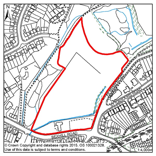
Figure 31: FB2 – Former West St Leonards Primary School
Site address: Former West St Leonards Primary School
Allocated use: Mixed use (residential and community)
Area: 3.92ha
Possible net capacity: 100
6.89 Site FB2 – Former West St Leonards Primary School is a predominately vacant site that could support at least 100 housing units.
6.90 The Council will require development to achieve high standards of sustainable design and construction. There is an area of tidal and fluvial flood risk (Zone 3) on the site and so a Flood Risk Assessment will be required and mitigation as advised by the report should be incorporated into any potential scheme. There is also the potential for surface water flood risk so suitable mitigation should also be included for this.
6.91 This site will be required to support a housing mix to include affordable housing and specific housing for wheelchair users. All vehicular access will be from Filsham Road. The capacity potential of this site indicates that a Transport Assessment and Travel Plan will be required, further advice is available from East Sussex County Council. Pedestrian/cycle links are proposed to the west and south. A buffer zone is indicated in the design brief (see section 5 of this Plan) at the junction of Filsham Road and Bexhill Road to accommodate a bus lane.
6.92 The site adjoins the South Saxons Local Wildlife Site (LWS) to the west and north, and this nature conservation area needs to be safeguarded in the layout of the site. Part of the site was formerly a tip and may still produce landfill gas. There is also a small area of contaminated land in the north-western corner of the site. An assessment of potential contamination will therefore be required. A buffer zone should be maintained on either side of the Hollington Stream in the southern and western parts of the site. The stream is an important ecological asset and is also engineered to avoid unacceptable flood risk so close working with the Council and the Environment Agency is encouraged and opportunities to create a feature of the stream should be explored.
6.93 The Community Hall in the southern part of the site is nearing the end of its useful life and developers will be expected to provide a replacement building. This could be sited adjacent to the existing building.
Policy FB2 - Former West St Leonards Primary School
Former West St Leonards Primary School is allocated for mixed use development including residential and community uses (possible net capacity 100 dwellings).
Development proposals for this site will:
Additional guidance is also given in a design brief for this site in section 5 of this Plan.
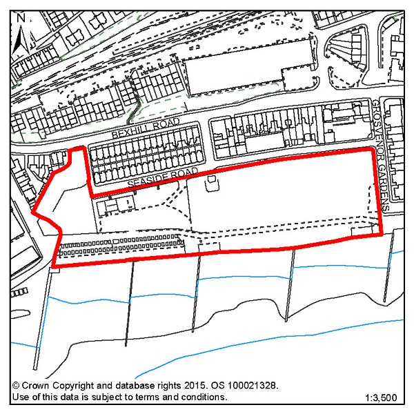
Figure 32: FB3 – Seaside Road, West St Leonards
Site address: Seaside Road, West St Leonards
Allocated use: Mixed use (residential and commercial)
Area: 2.22ha
Possible net capacity: 120
6.94 Site FB3 – Seaside Road, West St Leonards is a vacant brownfield site, and is part of the wider West Marina redevelopment area, which is an area of vacant and under-used land the regeneration of which has been a long term objective of the Council. Previous studies have indicated that this site could support 120 housing units as part of a mix of commercial, leisure and residential uses.
6.95 Seaside Road is one of the few remaining significant re-development sites on the Hastings/St Leonards seafront. It presents an opportunity to create a high quality development which, with the adjacent Cinque Ports Way site FB6, will both regenerate the area and act as a tourist attraction in its own right, as an addition to Hastings and the Old Town. The site is capable of accommodating both apartments and family housing. The site, given its size and location, will be expected to support a varied housing mix and may be required to include specific housing for wheelchair users, and affordable housing will also be required as part of the mix.
6.96 The Council will expect to see a high quality innovative design with particular regard to sustainability. The Grosvenor Gardens Conservation Area sits immediately to the east of this site. Any new development on this site must sustain and enhance the setting of the conservation area.
6.97 The location, scale and massing of housing units should have regard to the outlook of adjacent properties in Seaside Road and Grosvenor Gardens. Opportunities should be taken where possible to exploit the sea views that the site offers.
6.98 Developers will be expected to create a broad promenade for pedestrians and cyclists behind the seawall running east to west across the site. This should also act as a way of protecting views along the seafront. Improvements to the seawall will be required and the potential for vegetative shingle creation will need to be explored. There is tidal and fluvial flood risk (Zone 3) on the site and so a Flood Risk Assessment will be required and mitigation as advised by the report should be incorporated into any potential scheme.
6.99 The site is considered to be suitable for leisure and recreational uses, particularly those associated with the water. The site could also accommodate small scale kiosk style retail uses normally found at the seaside, a cafeteria and a public house/restaurant. These would be best sited behind the promenade. If possible, new permanent beach huts should be provided to replace the existing ones at the western end of the site. Opportunities for co-ordinating development with site FB6 should also be explored.
6.100 There is an underground tank in the northern part of the site opposite Seaside Way. This cannot be built over and must remain as open land. The eastern part of the site contains filled land and there have been previous commercial uses elsewhere on the site. Developers will be expected to provide an assessment of ground conditions and potential contamination. There is a playground on the site that must be retained or sympathetically relocated. The capacity potential of this site indicates that a Transport Assessment and Travel Plan will be required. Vehicular access is available to Cinque Ports Way, Seaside Road and Grosvenor Gardens, and the management of these accesses and likely road and junction improvements should occur in conjunction with site FB6. Further advice on transport matters is available from East Sussex County Council.
Policy FB3 - Seaside Road, West St Leonards
Seaside Road, West St Leonards is allocated for mixed use development including residential and commercial uses (possible net capacity 120 dwellings).
Development proposals for this site will:
Additional guidance is also given in a design brief for this site in section 5 of this Plan.
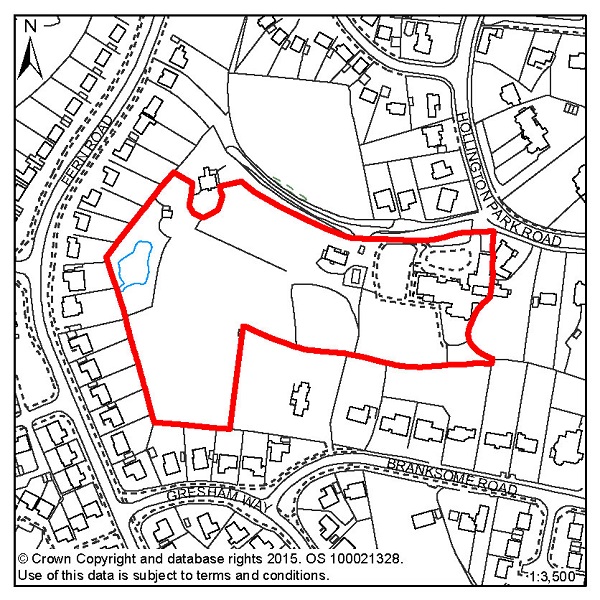
Figure 33: FB4 – Former Westerleigh School
Site address: Former Westerleigh School
Allocated use: Residential
Area: 2.15ha
Possible net capacity: 68
6.101 Site FB4 – Former Westerleigh School provides an opportunity for redevelopment since the closure of the private school.
6.102 The slope of the land, the existing mature trees within the site and important nature conservation issues will need to be explored in any scheme that is put forward for this site. The design brief for FB4 in section 5 of this Plan shows how a scheme might be able to accommodate development, green space, potential access points and boundary landscaping. At a density of 35 dwellings per hectare and given the areas shown on the brief that are protected, a minimum capacity of 68 dwellings could be achieved.
6.103 The site, given its size and location, will be expected to support a varied housing mix and may be required to include specific housing for wheelchair users, and affordable housing will also be required as part of the mix. Of particular importance for this site will be measures to reduce surface water flood risk, and Sustainable Drainage Systems (SUDs) are likely to be required. Connections between the green space protected on site and those existing green spaces off site will also need to be shown on any application to ensure the conservation and enhancement of the green infrastructure network. The capacity potential of this site indicates that a Transport Statement and Travel Plan Statement will be required. Further advice on transport matters is available from East Sussex County Council.
Policy FB4 - Former Westerleigh School
Former Westerleigh School is allocated for residential development (possible net capacity 68 dwellings).
Development proposals for this site will:
Additional guidance is also given in a design brief for this site in section 5 of this Plan.
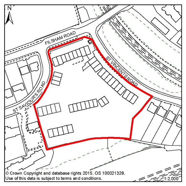
Figure 34: FB5 – Former Hastings College, St Saviours Road
Site address: Former Hastings College, St Saviours
Road
Allocated use: Residential
Area: 1.05ha
Possible net capacity: 44
6.104 Site FB5 – Former Hastings College, St Saviours Road is bounded by St Vincents Road, Filsham Road and St Saviours Road and currently comprises three and four storey brick built buildings which were most recently occupied by Hastings College prior to their relocation to new premises at Station Plaza. The southern boundary fronts a natural wooded area which slopes down to the railway line with views across to the sea. There are two storey houses immediately adjacent the site in St Vincents Road and St Saviours Road. There are recorded ecological constraints to the site that will require investigation and, as appropriate, conservation or mitigation prior to development. There is some surface water flood risk on site and, due to the size of the site, a Flood Risk Assessment is required. The capacity potential of this site indicates that a Transport Statement will be required. Further advice on transport matters is available from East Sussex County Council.
Policy FB5 - Former Hastings College, St Saviours Road
Former Hastings College, St Saviours Road is allocated for residential development (possible net capacity 44 dwellings).
Development proposals for this site will:
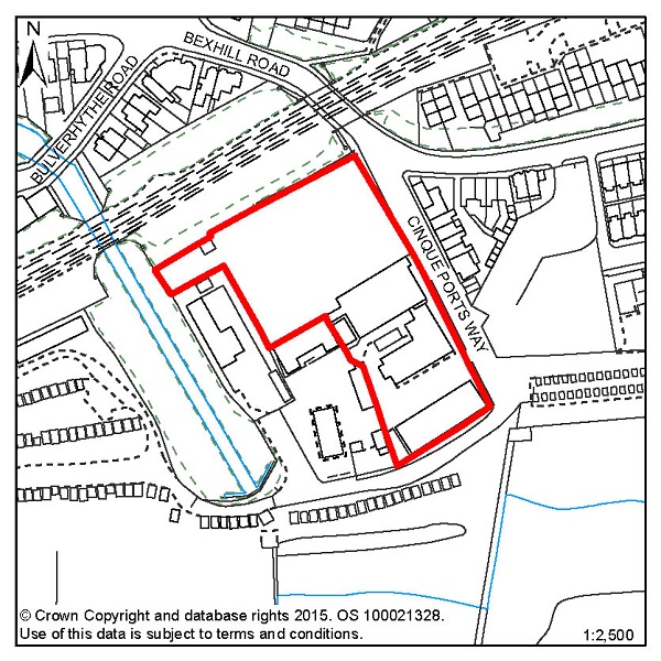
Figure 35: FB6 – Cinque Ports Way (Former Stamco Timber Yard and TA Centre)
Site address: Cinque Ports Way (Former Stamco Timber
and TA Centre)
Allocated use: Mixed use (residential and commercial)
Area: 0.65ha
Possible net capacity: 25
6.105 Site FB6 – Cinque Ports Way (Former Stamco Timber Yard and TA Centre) has redevelopment potential for a mix of uses including residential. Its seafront location also gives an opportunity for commercial and tourist development.
6.106 The site is potentially part of the West Marina redevelopment, an area of vacant and under-used land the regeneration of which has been a long term objective of the Council. This site could support 25 housing units as part of a mix of commercial and residential units, and these residences are the minimum for which the site is allocated.
6.107 The design brief for site FB6, in combination with FB3 (see section 5 of this Plan), indicates how it might be organised to accommodate both commercial and residential uses. It also shows potential access routes, and the management of these accesses and likely road and junction improvements should occur in conjunction with site FB3. The capacity potential of this site indicates that a Transport Report will be required. Further advice on transport matters is available from East Sussex County Council.
6.108 There is a Public Right of Way (and a National Cycle Route) running along the southern boundary, which it will be important to link to. There is a Local Wildlife Site adjacent to FB6 to the west; and avoidance of harm to it is of high importance and an impact assessment will be required.
6.109 This is a site that is in a flood risk area (from all types of flooding), protection and mitigation measures must be included in any scheme. Sustainable Drainage Systems (SUDs) are likely to be required along with potential contributions to the maintenance of the existing sea defences.
Policy FB6 - Cinque Ports Way (Former Stamco Timber Yard and TA Centre)
Cinque Ports Way (Former Stamco Timber Yard &and TA Centre) is allocated for mixed use development including residential and commercial uses (possible net capacity 25 dwellings).
Development proposals for this site will:
Additional guidance is also given in a design brief for this site in section 5 of this Plan.
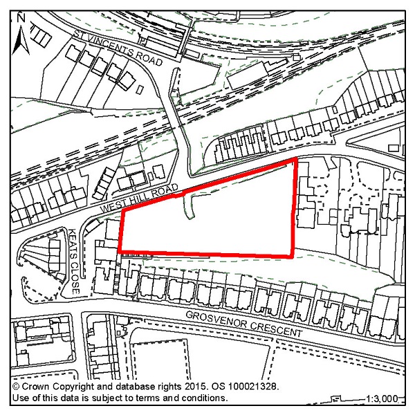
Figure 36: FB7 – 123-125 West Hill Road (Former Malmesbury House)
Site address: 123-125 West Hill Road (Former Malmesbury
House)
Allocated use: Residential
Area: 0.70ha
Possible net capacity: 117
6.110 Site FB7–123-125 West Hill Road (Former Malmesbury House) where in 1989, planning permission was granted for the erection of 117 dwellings in the form of apartment blocks (HS/OA/88/1323). In 2006, a Certificate of Lawful Use was granted stating that this development had commenced within three years of consent being granted and could therefore be completed (HS/PR/05/00980).
6.111 A new scheme would provide an opportunity to incorporate the latest thinking on sustainable design and construction into this site. The possible net capacity of 117 dwellings reflects the existing consent. The capacity potential of this site indicates that a Transport Assessment and Travel Plan will be required. Further advice on transport matters is available from East Sussex County Council.
6.112 The site occupies an elevated prominent location at the western end of the Grosvenor Gardens Conservation Area and is visible from a distance, particularly from the direction of the seafront. Any development must therefore respect longer distance views of the site as well as its immediate surroundings.
6.113 The cliff to the rear of the site is a Local Wildlife Site. Applicants will be required to submit an ecology and arboriculture report. Applicants will also be required to demonstrate that their development will not threaten the stability of the cliff.
Policy FB7 - 123-125 West Hill Road (Former Malmsbury House)
123-125 West Hill Road (Former Malmsbury House) is allocated for residential development (possible net capacity 117 dwellings).
Development proposals for this site will:
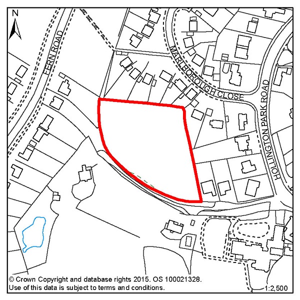
Figure 37: FB8 – Former Westerleigh School, Playing Fields
Site address: Former Westerleigh School, Playing Fields
Allocated use: Residential
Area: 0.56ha
Possible net capacity: 7
6.114 Site FB8 – Former Westerleigh School, Playing Fields is across a narrow road from the main former school site (site FB4). It is almost completely surrounded by residential properties and is a relatively flat and open Greenfield site. The capacity potential of this site indicates that a Transport Report will be required. Further advice on transport matters is available from East Sussex County Council.
Policy FB8 - Former Westerleigh School, Playing Fields
Former Westerleigh School, Playing Fields is allocated for residential development (possible net capacity 7 dwellings).
Development proposals for this site will:
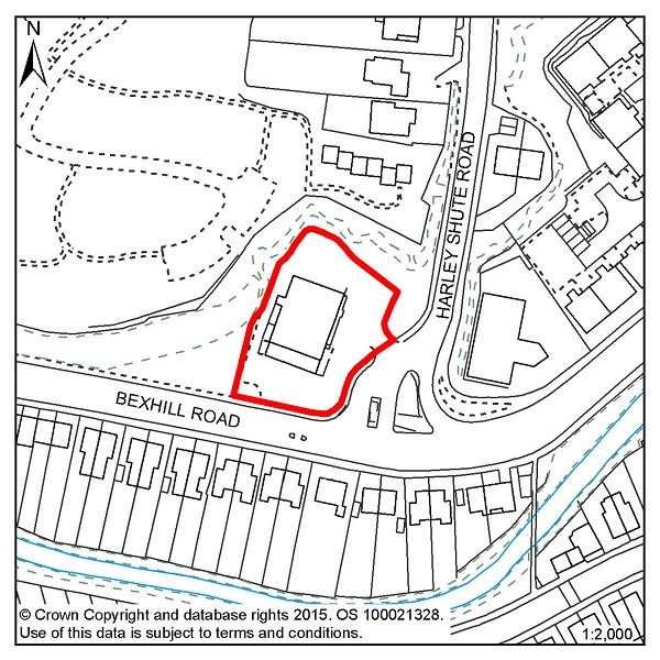
Figure 38: FB9 – 190 Bexhill Road
Site address: 190 Bexhill Road
Allocated use: Residential
Area: 0.19ha
Possible net capacity: 32
6.115 Site FB9 – 190 Bexhill Road is on the junction of Harley Shute Road and Bexhill Road. It is a relatively flat site that is excavated from the cliff behind and is currently used for a retail premises. Just to the south of the site is an area of flood risk that might impact upon the site and in order to avoid any adverse impacts, a Flood Risk Assessment will be required. The capacity potential of this site indicates that a Transport Report will be required. Further advice on transport matters is available from East Sussex County Council.
Policy FB9 - 190 Bexhill Road
190 Bexhill Road is allocated for residential development (possible net capacity 32 dwellings).
Development proposals for this site will:
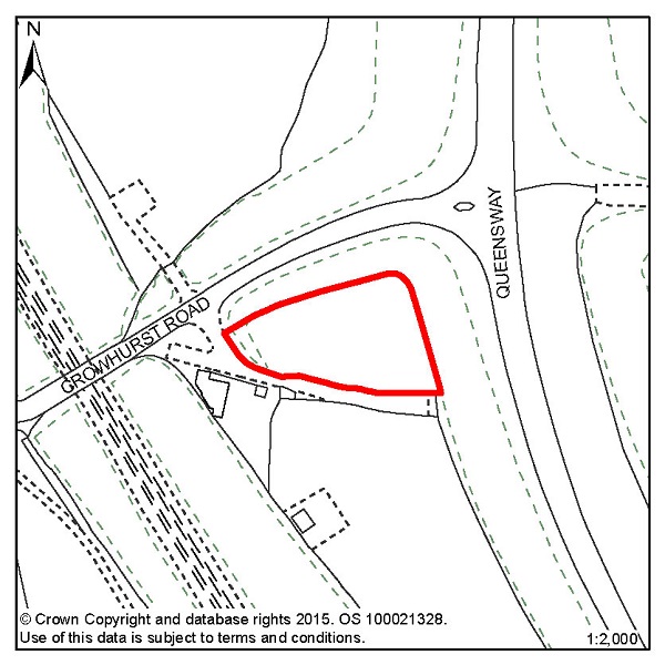
Figure 39: FB10 – Land south of Crowhurst Road
Site address: Land south of Crowhurst Road
Allocated use: Permanent site for Gypsies and Travellers
Area: 0.17ha
Possible net capacity: 2 pitches
6.116 Site FB10 – Land south of Crowhurst Road is a small site that is near to Queensway, and Queensway has connections to the wider road network. Access onto the site will need to be improved, but there is enough space to accommodate two permanent residential pitches for gypsies and travellers and ancillary buildings on site.
6.117 The site has a good tree belt at its perimeters, and the Council would wish to see this retained as far as is practicable. The site is also close to sensitive ecological areas, so any potential scheme should demonstrate an understanding of any potential impact and how any adverse impact is avoided or mitigated as appropriate.
6.118 The Provision of Permanent sites for Gypsies, Travellers and Travelling Showpeople paper (Oct. 2012) indicates that, up to 2016, there is a present need for two permanent pitches. Site FB10 meets this requirement. The Council, along with local partners (including East Sussex County Council, Rother District Council and other relevant stakeholders) will continue to monitor and review the needs of the Gypsy, Traveller and Travelling Showpeople communities. The findings of relevant reports will be published and sites, as appropriate, will be identified as having the potential to accommodate those needs. The assessment criteria for potential sites are included in policy H5 of the Planning Strategy and the general policies of this Plan.
Policy FB10 - Land south of Crowhurst Road
Land south of Crowhurst Road, is allocated for a permanent site for Gypsies and Travellers (possible net capacity 2 pitches).
Development proposals for this site will:
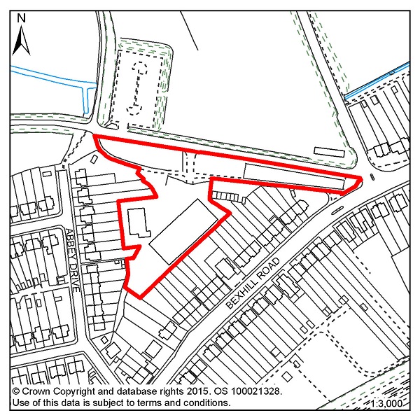
Figure 40: FB13 – Hastings Garden Centre, Bexhill Road
Site address: Hastings Garden Centre, Bexhill Road
Allocated use: Residential
Area: 0.78ha
Possible net capacity: 12
6.119 Site FB13 – Hastings Garden Centre, Bexhill Road. An earlier assessment found that there was an unacceptable flood risk on the site, but following new modelling work from the Environment Agency, this risk has been much reduced. There is still a small area of the site in Flood Zone 2 so a Flood Risk Assessment will be required, however, the site would be acceptable as a Brownfield redevelopment.
6.120 The site is located close to the Combe Valley Countryside Park and new play facilities, so proposals for the site will need to take these into account. It also falls within an Archaeological Notification Area so proposals will be referred to the East Sussex County Council and, in consultation with the County Archaeologist, further investigation works and/or conservation may be required. The capacity potential of this site indicates that a Transport Report will be required. Further advice on transport matters is available from East Sussex County Council.
Policy FB13 - Hastings Garden Centre, Bexhill Road
Hastings Garden Centre, Bexhill Road is allocated for residential development (possible net capacity 12 dwellings).
Development proposals for this site will:
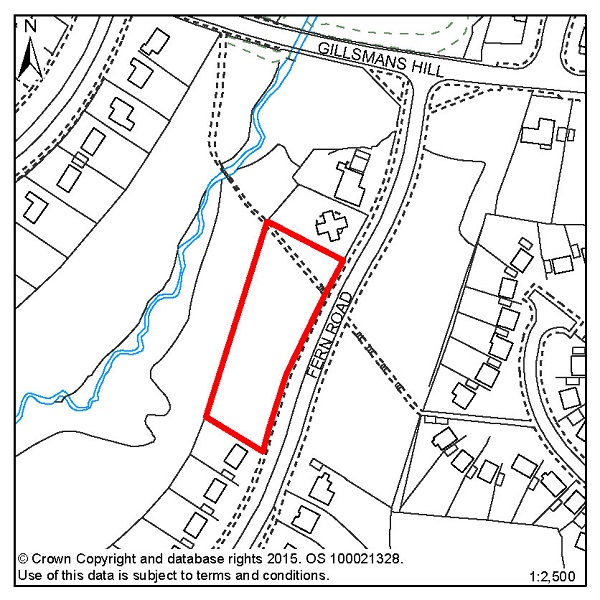
Figure 41: FB14 – Land north of 31 Fern Road
Site address: Land north of 31 Fern Road
Allocated use: Residential
Area: 0.28ha
Possible net capacity: 10
6.121 Site FB14 - Land north of 31 Fern Road is undeveloped land between existing residential developments. Development of this site would represent an acceptable continuation of the street scene. The site is within a Local Wildlife Site and adjacent to a newly designated Local Nature Reserve, so proposals for the site will need to be sympathetic to this and avoid adverse impacts as far as is possible. The capacity potential of this site indicates that a Transport Report will be required. Further advice on transport matters is available from East Sussex County Council.
Policy FB14 - Land north of 31 Fern Road
Land North of 31 Fern Road is allocated for residential development (possible net capacity 10 dwellings).
Development proposals for this site will:
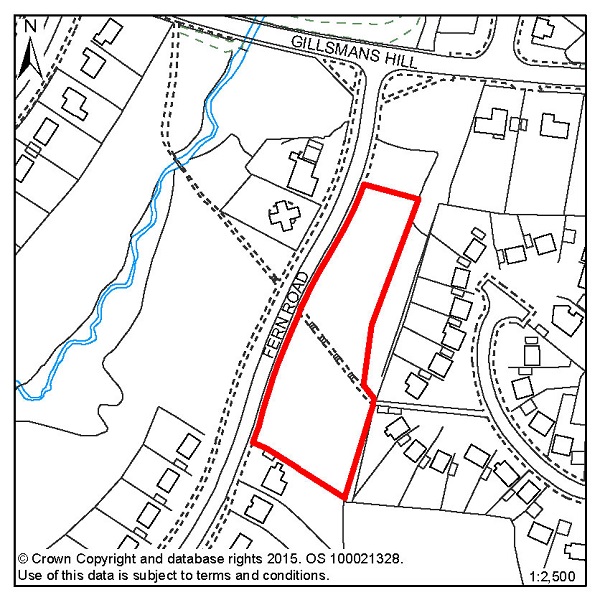
Figure 42: FB15 – Land north of 14 Fern Road
Site address: Land north of 14 Fern Road
Allocated use: Residential
Area: 0.46ha
Possible net capacity: 14
6.122 Site FB15 - Land north of 14 Fern Road is undeveloped land next to existing residential developments. Development of this site would represent an acceptable continuation of the street scene. The site is across the road from a Local Wildlife Site and a newly designated Local Nature Reserve, so proposals will need to be sympathetic to this and avoid adverse impacts as far as is possible. The capacity potential of this site indicates that a Transport Report will be required. Further advice on transport matters is available from East Sussex County Council.
Policy FB15 - Land north of 14 Fern Road
Land North of 14 Fern Road is allocated for residential development (possible net capacity 14 dwellings).
Development proposals for this site will:
© Crown Copyright and database rights [2015]. OS [100021328]. Use of this data is subject to terms and conditions.
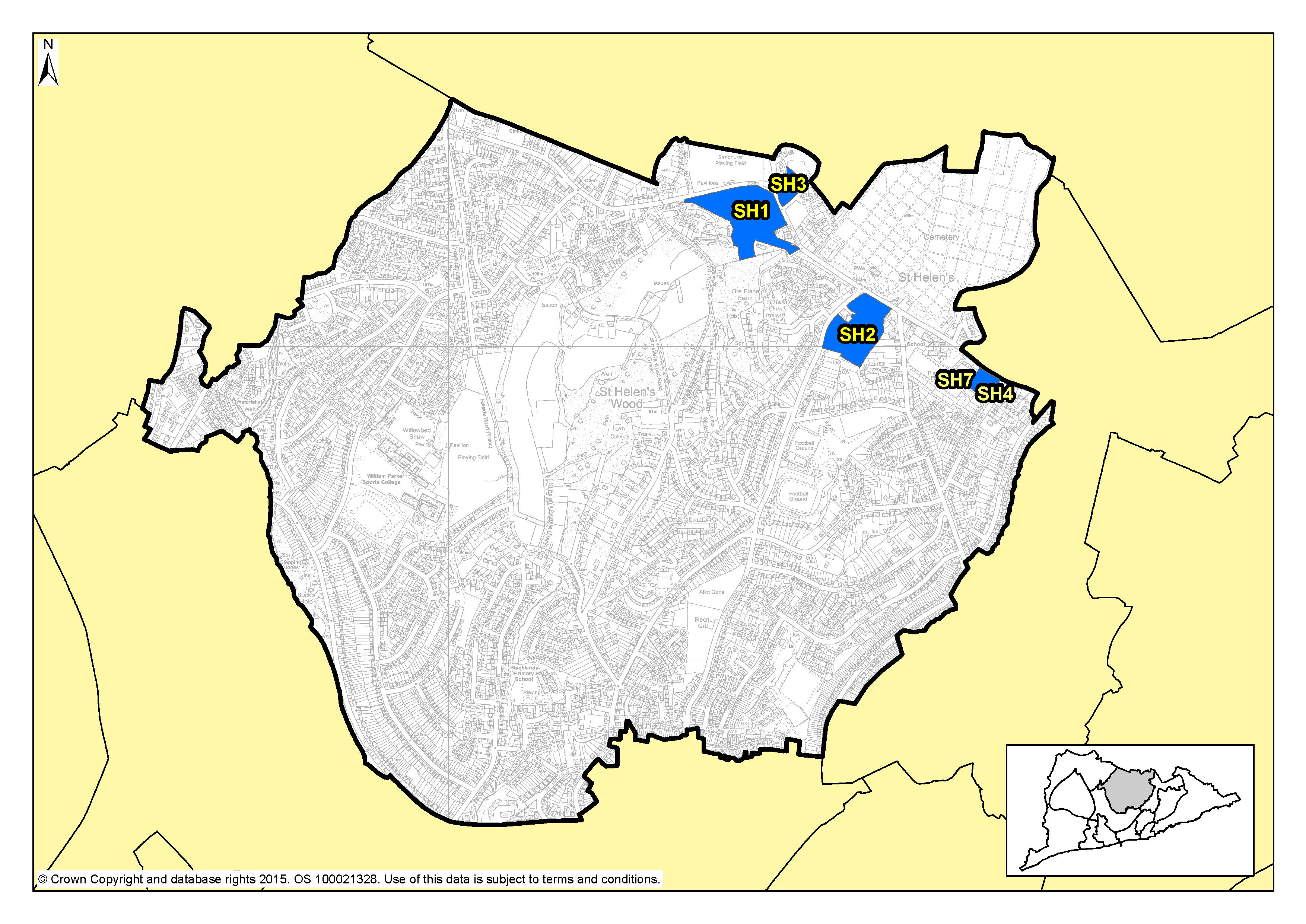
Figure 43: Focus Area 4 – St Helens
6.123 This Focus Area is dominated by St Helen's Wood, a local nature reserve with meadowland, woodlands, ponds and streams. To the northern end, St Helen's Wood joins with playing fields and open spaces at The Ridge and out to the High Weald countryside beyond. The St Helens Focus Area stretches from Parker Road in the east to the Conquest Hospital, and from St Helen's Road in the south up to the northern edge of the Borough at The Ridge.
6.124 Housing in St Helens is mostly 20th Century post war, although there are Victorian terraces and larger 19th Century detached homes in the south east of the area. Elsewhere, there are a few older houses that were once more rural homes that have been overtaken by Hastings' expansion. This is a Focus Area where there is another very eclectic range of homes and architectural styles. Around St Helen's Wood Nature Reserve there are individually designed homes, with large, often wooded gardens. Away from the woods some of the housing is more modest.
6.125 Although this is primarily a residential area, St Helens is also home to the Ark William Parker Academy. There is also the cemetery and crematorium, Hastings United football stadium at the Pilot Field, the Firs former football ground, and various playing fields and allotments. St Helens is less well served by shops and employment than other Focus Areas, with most services being just over the borders into other areas. There are some individual shops, pubs and facilities but residents of St Helens often have to travel to get to their jobs and the services they need, with 2001 Census data suggesting car ownership in this area is high, which reflects this fact.
6.126 This is one of the most populous of our Focus Areas, with 11,000 inhabitants, although it is also one of the largest by area. It is the second least deprived part of the Borough (ONS), and 78% of the homes are owner-occupied (according to census data). The population here is older than the Borough average, with more than a third above retirement age, the second highest in the Borough (2001 Census).
6.127 Policy FA2 of The Planning Strategy sets out the requirement for 210-250 new homes to be built up to 2028; with most potential development opportunities on Elphinstone Road and The Ridge. Where new development does occur, we would expect it to be in keeping with the suburban and semi-rural nature of the area. Densities of new developments are likely to be higher than current low-density housing. Small flatted developments could be acceptable, with a mix of designs to include houses with gardens where appropriate. Social rented and affordable housing would also be encouraged here, as there's currently little of it in this area.
6.128 In order to maintain and enhance the communities here, opportunities for mixed use development to include local services could be investigated and the inclusion of live/work units may be appropriate. We will encourage the retention of existing employment land in St Helens that is at a premium. Development proposals, particularly along The Ridge, will need to show consideration of the traffic impact onto and off locally important traffic routes.
6.129 St Helen's Wood nature reserve will remain protected from development. Any development at the edge of St Helen's Wood will need to be particularly sympathetic to the character of the reserve, and schemes should aim to preserve views and access to the undeveloped wooded edges. Development proposals on the main roads, and particularly The Ridge, will need to appreciate their potential impact on traffic locally, especially when the new Bexhill-Hastings Link Road is built and new regular routes through the Borough are established.
| Site reference | Address | Allocation (including potential number of homes) | Area (ha) | Does the site have a brief in section 5? |
| SH1 | Land adjacent to Sandrock Park, The Ridge | Residential (80) | 3.85 | ✔ |
| SH2 | Land at Osborne House, The Ridge | Residential (55) | 2.80 | ✖ |
| SH3 | Hurst Court, The Ridge | Residential (20) | 0.66 | ✔ |
| SH4 | Mount Denys, Pinehill and Ridgeway | Residential (31) | 0.64 | ✔ |
Table 6: Residential, mixed use and other allocations for St Helens
Figure 44: SH1 – Land adjacent to Sandrock Park, The Ridge
Site address: Land adjacent to Sandrock Park, The
Ridge
Allocated use: Residential
Area: 3.85ha
Possible net capacity: 80
6.130 Site SH1 – Land adjacent to Sandrock Park, The Ridge is a relatively flat site. The western part of the site is unused and the eastern part is a playing field which is under-used.
6.131 There is a tree screen along the frontage with The Ridge and on part of the site's western boundary. These existing boundary trees are the most significant landscape characteristic of the area, and would need to be managed as part of any development. Retention and management of the existing trees and hedges would be the primary means of mitigation. A new access would be required. Development proposals will need to show consideration of the transport impact along The Ridge. Further advice on transport matters is available from East Sussex County Council. The site is also within an Archaeological Notification Area. Due to the size of the site, a Flood Risk Assessment is required.
6.132 The site is between protected green spaces – St. Helen's Wood Local Wildlife Site to the south and the Sandhurst recreation ground across The Ridge to the north, so it will be important that any scheme that is proposed clearly shows how links in the green infrastructure network will be retained. This could be achieved through retaining trees, pathways including a Public Right of Way and some open space which can also be used for informal recreation. New development on the site will also be required to make a contribution to the playing fields opposite and existing play facilities in the surrounding area.
6.133 The south east of the site includes “The Lodge” (Lodge Cottage), a building, historically associated with a former entrance to the manor Ore Place, original in its form and detail, now vacant and in a state of disrepair. It is a building of notable architectural appearance and character and forms part of a group of buildings which include St Helens Church and a former school building. All of which contribute to the sense of place, the setting of the Ore Place Conservation Area. The Lodge should be retained in any overall development and any development must sustain and enhance the significance and setting of this building, and in the wider context of the Conservation Area. The site has no existing sewerage capacity and will require a connection to the network. The size of this site means that plans should include a good mix of housing types including affordable housing and they may also be required to include specific housing for wheelchair users.
Policy SH1 - Land adjacent to Sandrock Park, The Ridge
Land adjacent to Sandrock Park, The Ridge is allocated for residential development (possible net capacity 80 dwellings).
Development proposals for this site will:
Additional guidance is also given in a design brief for this site in section 5 of this Plan.
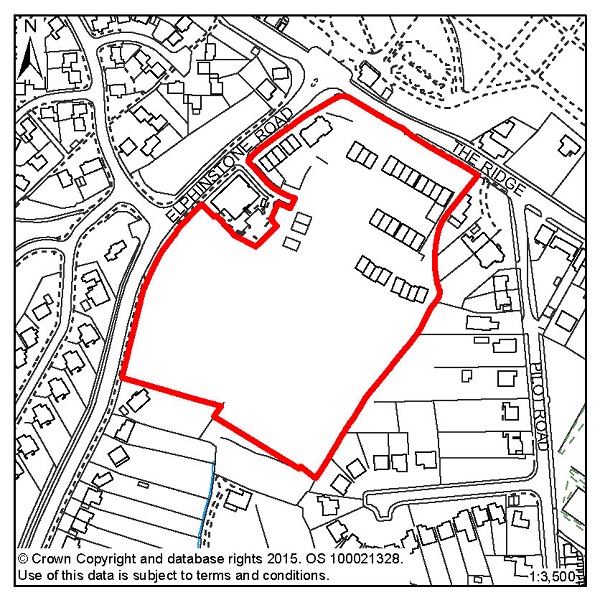
Figure 45: SH2 – Land at Osborne House, The Ridge
Site address: Land at Osbourne House, The Ridge
Allocated use: Residential
Area: 2.80ha
Possible net capacity: 55
6.134 Site SH2 – Land at Osborne House, The Ridge had been host to a substantial Victorian property as well as a number of substantial outbuildings set within extensive grounds. The grounds are terraced because the terrain falls away significantly south of The Ridge. There are recorded ecological constraints on this site and because the size of the site is over 1 hectare, a Flood Risk Assessment is required. Development proposals will need to show consideration of the transport impact along The Ridge. Further advice on transport matters is available from East Sussex County Council.
6.135 The site is within an Archaeological Notification Area so any proposals put to the Council will be referred to East Sussex County Council and, in consultation with the County Archaeologist, further investigation works and/or conservation may be required.
Policy SH2 - Land at Osborne House, The Ridge
Land at Osborne House, The Ridge is allocated for residential development (possible net capacity 55 dwellings).
Development proposals for this site will:
Figure 46: SH3 – Hurst Court, The Ridge
Site address: Hurst Court, The Ridge
Allocated use: Residential
Area: 0.66ha
Possible net capacity: 20
6.136 Site SH3 – Hurst Court, The Ridge is a relatively level site adjacent to The Ridge on a prominent corner.
6.137 Wildlife and tree cover are likely to affect the developable area of the site. It is therefore required that any potential scheme includes detailed ecological studies and that measures are put in place to protect the ecology. This site commands a prominent position on The Ridge, so any development that faces onto the road will need to be of sufficient quality and proportion to occupy such a place. Development will be expected to support a varied housing mix including affordable housing. Development proposals must show consideration of the transport impact along The Ridge. Further advice on transport matters is available from East Sussex County Council.
6.138 This site is within an Archaeological Notification Area so any proposals put to the Council will be referred to East Sussex County Council and, in consultation with the County Archaeologist, further investigation works and/or conservation may be required.
6.139 It will be important that any scheme that is proposed clearly shows how links in the green infrastructure network will be retained. Given the potential size of the development and its proximity to the Sandhurst recreation ground, any development will be expected to contribute to the enhancement of that facility.
Policy SH3 - Hurst Court, The Ridge
Hurst Court, The Ridge is allocated for residential development (possible net capacity 20 dwellings).
Development proposals for this site will:
Additional guidance is also given in a design brief for this site in section 5 of this Plan.
Figure 47: SH4 – Mount Denys, Pinehill and Ridgeway
Site address: Mount Denys, Pinehill and Ridgeway
Allocated use: Residential
Area: 0.64ha
Possible net capacity: 31
6.140 Site SH4 – Mount Denys, Pinehill and Ridgeway contains buildings that are currently used by East Sussex County Council Social Services. These are likely to become vacant during the Plan period.
6.141 Given the existing character of the surrounding area, the site is suitable for a high density development with a suggested capacity of 31 dwellings. This site will be expected to support a varied housing mix, including affordable housing.
6.142 The site already has some boundary treatment against The Ridge that includes grass and trees; retaining and reinforcing this should be part of any scheme submitted. East Sussex County Council has advised that increasing the amount of traffic that directly accesses The Ridge should be avoided with the main access to the site from St Helens Down. The County Council has also suggested that improvements might be required to the junction of The Ridge and St Helens Down to accommodate redevelopment on this site. Proposals for this site will need to include a Transport Report, especially because of its proximity to The Ridge. Further advice on transport matters is available from East Sussex County Council.
6.143 This site is within an Archaeological Notification Area, so any proposals put to the Council will be referred to East Sussex County Council and, in consultation with the County Archaeologist, further investigation works and/or conservation may be required.
6.144 The design brief for this site (see section 5 of this Plan) highlights the access and road improvement issues and that there are some green spaces that could be retained.
Policy SH4 - Mount Denys, Pinehill and Ridgeway
Mount Denys, Pinehill and Ridgeway is allocated for residential development (possible net capacity 31 dwellings).
Development proposals for this site will:
Additional guidance is also given in a design brief for this site in section 5 of this Plan.
© Crown Copyright and database rights [2015]. OS [100021328]. Use of this data is subject to terms and conditions.
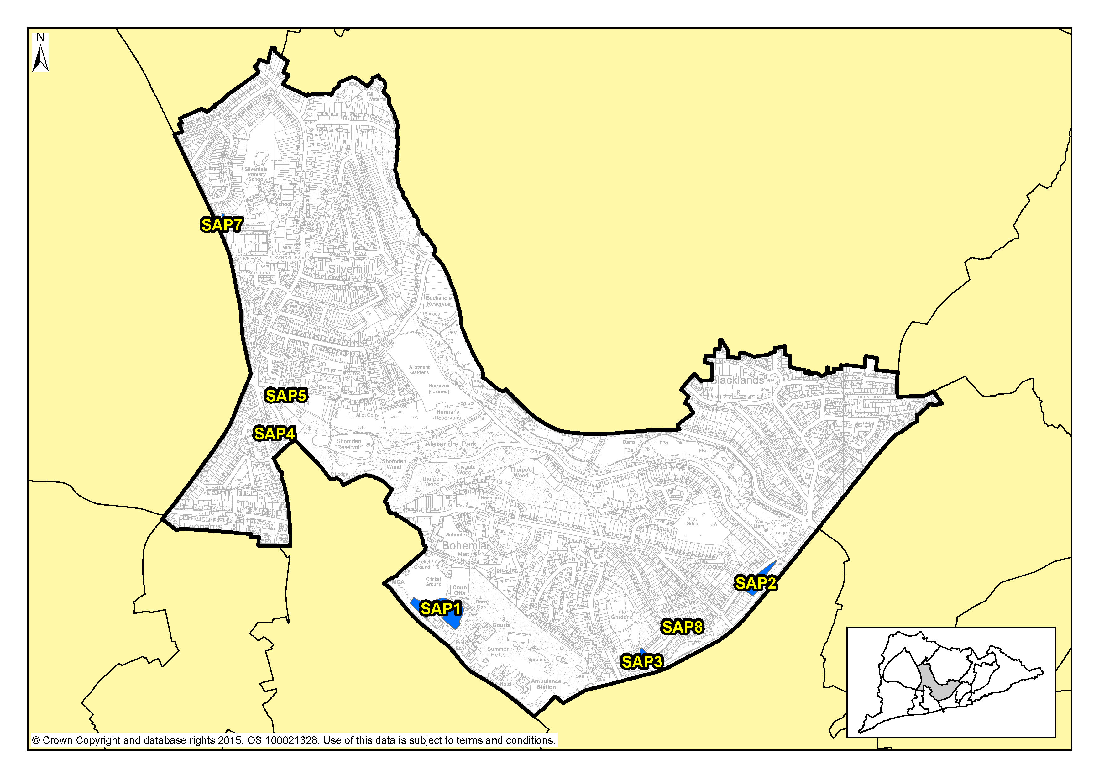
Figure 48: Focus Area 5 – Silverhill & Alexandra Park
6.147 From the edges of the town centre to the Silverhill shopping centre, this Focus Area follows the course of Alexandra Park, from its formal greens and gardens at the southern end to the wild and wooded reaches of Shornden and Old Roar Gill, which is a waterfall that tumbles into a narrow gorge filled with ferns and mosses.
6.148 Housing to the southern end of the area and around Silverhill centre is largely Victorian. Elsewhere, the housing is mostly inter-war, with some very elegant Art Deco houses along the edge of Alexandra Park. The area has shops and other facilities, and most of these are in the Silverhill shopping area. There are fewer of these to the south, where local people are more likely to go to Hastings Town Centre for shopping, doctors and other facilities.
6.149 Employment in this Focus Area is generally centred on the Silverhill shopping centre, with a few small industrial premises, as well as retail. There is also a crop of civic buildings along Bohemia Road, including the law courts, Hastings' principal police station, a fire station, ambulance station, some industrial units, and Horntye Sports Centre which includes Hastings cricket ground. This part of the area also includes some interesting archaeology, including an ice house and the 'roman baths'.
6.150 The area is characterised by urban green space: to the west, Summerfields Woods, a local nature reserve; in the south Linton Gardens; and to the east the border runs along the eastern edge of the award-winning Alexandra Park, the Borough's principal urban park. Alexandra Park includes the usual seaside attractions at the southern end, where there is a busy café, flower gardens, children's playground, tennis courts, bowls and lakes. Further up, it becomes more natural, with woodlands and fishing lakes. The area includes Summerfields Woods, a local nature reserve in a steep-sided wooded valley, where you can find the remains of an old walled garden, now being restored. There are allotments in this area too, and other small green spaces.
6.151 In spite of all the open space, there are still over 10,000 people living in this Focus Area, with some parts, around Silverhill especially, relatively densely populated (40 people per hectare according to the 2001 Census). The age range of the population is evenly spread, displaying a mix of families with children, working age people and retirees.
6.152 The tenures in this focus area are two-thirds owner-occupation according to 2001 Census data and, in contrast to many of the other Focus Areas, there is a relatively high proportion (21%) of private rented accommodation in the Silverhill & Alexandra Park Focus Area. This last statistic could be reflective of a local population that is potentially less likely to stay in the same home as long as home owners.
6.153 This is an area dominated by protected open space: Alexandra Park, nature reserves, allotments and public playing fields. The significant public open spaces will be protected and enhanced. In particular, we would like to see better connections between Alexandra Park, Linton Gardens, Summerfields Woods, the town centre and seafront, with walking routes, cycling routes, and public transport key to this. We will encourage their use and perhaps increase community management.
6.154 Policy FA2 of the Planning Strategy plans for 300-360 new homes in the Silverhill & Alexandra Park Planning Focus Area up to 2028. A particular opportunity site could be at the Horntye sports centre. Given the relatively high densities of population in this Focus Area, and also the presence of Alexandra Park and other open space, potential development schemes will need to pay particular attention to innovative design solutions that address density and complement the open spaces. Opportunities to protect and enhance the connections for people and wildlife between the green spaces in this Focus Area should be fully investigated in connection with any development scheme that comes forward.
6.155 Silverhill is the commercial hub of the area, and we would expect this to remain so, and indeed to develop and improve as a retail centre. Here, there could be an opportunity for innovative design, so ideas for modern, commercial or retail development would be welcome. Away from the retail centre, Silverhill has other employment sites, and we would encourage their retention. There could be the potential to integrate appropriate employment opportunities into the more residential areas, including, for example, small workshops or live/work units.
| Site reference | Address | Allocation (including potential number of homes) | Area (ha) | Does the site have a brief in section 5? |
| SAP1 | Horntye Park | Residential (115) | 1.01 | ✖ |
| SAP2 | Hollingsworth Garage, Braybrooke Road | Residential (56) | 0.40 | ✔ |
| SAP3 | 12-19 Braybrooke Terrace | Residential (25) | 0.23 | ✔ |
| SAP4 | 347-349 London Road | Residential (18) | 0.15 | ✖ |
| SAP5 | Silver Springs Medical Practice, Beaufort Road |
Residential (9) | 0.12 | ✖ |
| SAP7 | Bilmore Corner, Battle Road | Residential (8) | 0.06 | ✖ |
| SAP8 | 4 Wykeham Road | Residential (6) | 0.03 | ✖ |
Table 7: Residential, mixed use and other allocations for Silverhill & Alexandra Park
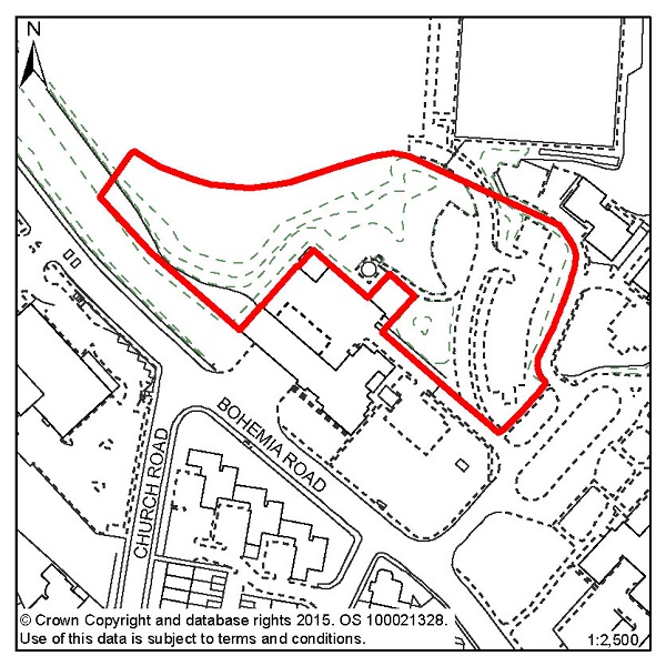
Figure 49: SAP1 - Horntye Park
Site address: Horntye Park
Allocated use: Residential
Area: 1.01ha
Possible net capacity: 115
6.156 Site SAP1 – Horntye Park is at the entrance to the sports complex. It is elevated from Bohemia Road and has a mature tree boundary. The access to the sports facilities will need to be maintained. Any loss of sports facilities will need to be compensated for. Given the size and location of the site the Council will expect any scheme to support a varied housing mix and may be required to include specific housing for wheelchair users, and affordable housing will also be required as part of the mix.
6.157 There is a Grade II Listed ice house within this site which will need to be maintained by the site owner and/or developer. It is also required that occasional public access to the structure is provided for over the long term.
6.158 The capacity potential of this site indicates that a Transport Assessment and Travel Plan will be required. Further advice on transport matters is available from East Sussex County Council. Due to the size of the site, a Flood Risk Assessment will be required.
Policy SAP1 - Horntye Park
Horntye Park is allocated for residential development (possible net capacity 115 dwellings).
Development proposals for this site will:
Figure 50: SAP2 – Hollingsworth Garage, Braybrooke Road
Site address: Hollingsworth Garage, Braybrooke Road
Allocated use: Residential
Area: 0.40ha
Possible net capacity: 56
6.159 Site SAP2 – Hollingsworth Garage, Braybrooke Road is a relatively narrow site that was formerly home to a motor vehicle garage, between Braybrooke Road and the railway lines approaching Hastings Station. The site is a prominent one, overlooking the town centre with views to the Castle. Submitted schemes will therefore need to show how they have had regard to the impact on both the local street scene and when seen from further afield. This site lies immediately to the south of the Blacklands Conservation Area. Any development on this site will need to sustain and enhance the setting of that Conservation Area.
6.160 The shape and topography of the site mean that access options are limited, and that the on-site parking that will need to be provided may require innovative solutions. The previous use of the site means that land contamination might be an issue and should be investigated. The tree belt between the site and the railway line, mostly off-site, should be retained and any adverse impact upon it avoided.
6.161 Given the size and location of the site the Council will expect any scheme to support a varied housing mix and may be required to include specific housing for wheelchair users, and affordable housing will also be required as part of the mix. The capacity potential of this site indicates that a Transport Statement and Travel Plan Statement will be required. Further advice on transport matters is available from East Sussex County Council.
Policy SAP2 - Hollingsworth Garage, Braybrooke Road
Hollingsworth Garage, Braybrooke Road is allocated for residential development (possible net capacity 56 dwellings).
Development proposals for this site will:
Additional guidance is also given in a design brief for this site in section 5 of this Plan.
Figure 51: SAP3 – 12-19 Braybrooke Terrace
Site address: 12-19 Braybrooke Terrace
Allocated use: Residential
Area: 0.23ha
Possible net capacity: 25
6.162 Site SAP3 – 12-19 Braybrooke Terrace is a relatively narrow site that is bounded by high retaining walls and significant level changes adjacent to it. Access options for the site are limited, and on-site parking that will need to be provided may require innovative solutions. The high retaining walls and limited rear aspect mean that the amenity of future occupants must be considered in any potential scheme; it must be demonstrated that sufficient daylight can enter all the dwellings that are proposed on site.
6.163 The trees in the north of the site and adjacent to it, in Linton Gardens (a locally important historic park) should also be retained, for their heritage and ecological value. Beneath the site there is a storm water retention tunnel and Southern Water will be invited to comment on any submitted proposals. It is recommended that advice is sought from Southern Water at an early stage by any potential applicant. This site will be expected to support a varied housing mix, including affordable housing. The capacity potential of this site indicates that a Transport Report will be required. Further advice on transport matters is available from East Sussex County Council.
6.164 The design brief for this site (see section 5 of this Plan) highlights the access issues and tree cover that need to be considered.
Policy SAP3 - 12-19 Braybrooke Terrace
12-19 Braybrooke Terrace is allocated for residential development (possible net capacity 25 dwellings).
Development proposals for this site will:
Additional guidance is also given in a design brief for this site in section 5 of this Plan.
Figure 52: SAP4 – 347-349 London Road
Site address: 347-349 London Road
Allocated use: Residential
Area: 0.15ha
Possible net capacity: 18
6.165 Site SAP4 – 347-349 London Road is a cleared brownfield site where there was previously a large building used as a dance school. The site offers the opportunity for residential development, an important consideration of which will be the access and egress onto London Road. This site will be expected to support a varied housing mix, including affordable housing. The capacity potential of this site indicates that a Transport Report will be required. Further advice on transport matters is available from East Sussex County Council.
Policy SAP4 - 347-349 London Road
347-349 London Road is allocated for residential development (possible net capacity 18 dwellings).
Development proposals for this site will:
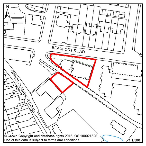
Figure 53: SAP5 – Silver Springs Medical Practice, Beaufort Road
Site address: Silver Springs Medical Practice, Beaufort
Road
Allocated use: Residential
Area: 0.12ha
Possible net capacity: 9
6.166 Site SAP5 – Silver Springs Medical Practice, Beaufort Road is an active medical practice that is looking to relocate. The site offers the opportunity for its redevelopment to housing. There is a proposed cycle route that runs between the two parcels of land that make up this allocation and this route should be preserved, and contributions to its creation and management may be sought. The capacity potential of this site indicates that a Transport Report will be required. Further advice on transport matters is available from East Sussex County Council.
Policy SAP5 - Silver Springs Medical Practice, Beaufort Road
Silver Springs Medical Practice, Beaufort Road is allocated for residential development (possible net capacity 9 dwellings).
Development proposals for this site will:
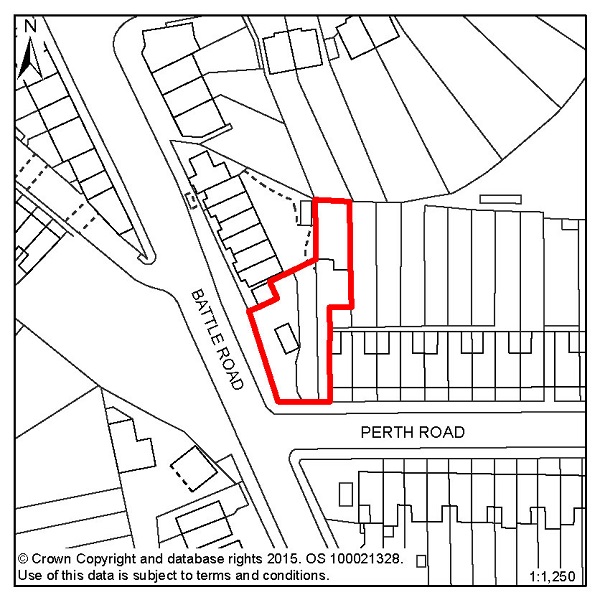
Figure 54: SAP7 – Bilmore Corner, Battle Road
Site address: Bilmore Corner, Battle Road
Allocated use: Residential
Area: 0.06ha
Possible net capacity: 8
6.167 Site SAP7 – Bilmore Corner, Battle Road is vacant and represents a good opportunity for residential development. The site is in a residential area close to local shops and services. The capacity potential of this site indicates that a Transport Report will be required. Further advice on transport matters is available from East Sussex County Council.
Policy SAP7 - Bilmore Corner, Battle Road
Bilmore Corner, Battle Road is allocated for residential development (possible net capacity 8 dwellings).
Development proposals for this site will:
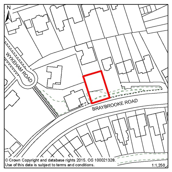
Figure 55: SAP8 – 4 Wykeham Road
Site address: 4 Wykeham Road
Allocated use: Residential
Area: 0.03ha
Possible net capacity: 6
6.168 Site SAP8 – 4 Wykeham Road is a relatively small and sloping site. It is in a residential area near to Hastings Railway Station and other town centre shops and services. The capacity potential of this site indicates that a Transport Report will be required. Further advice on transport matters is available from East Sussex County Council.
Policy SAP8 - 4 Wykeham Road
4 Wykeham Road is allocated for residential development (possible net capacity 6 dwellings).
Development proposals for this site will:
© Crown Copyright and database rights [2015]. OS [100021328]. Use of this data is subject to terms and conditions.
Figure 56: Focus Area 6 – Maze Hill & Burtons' St Leonards
6.169 This area covers the 'historic' part of St Leonards, from the 1930s Art Deco Marine Court on the seafront, to Markwick Terrace and its surrounding streets, extending in the east from London Road to the edge of West Marina gardens. Much of Maze Hill & Burtons' St Leonards has conservation area status. It is characterised by a mixture of Regency and Victorian villas and imposing terraces characterised by elegant gleaming white housing, interspersed with formal gardens at Markwick Terrace and St Leonards Gardens (one of two parks in the Borough that are on the English Heritage Register of Parks and Gardens of Special Historic Interest).
6.170 Burtons’ St Leonards itself is of great architectural and townscape interest as it forms the core of the original Regency new town designed and built by James Burton and his son Decimus between 1828 and 1835. Their vision included a mix of architectural styles, from Scottish baronial 'castles’ to mock-Tudor manor houses. To the south east of the area is Mercatoria, the old 'tradesmen’s’ area built to serve Burtons’ St Leonards. Here, houses are smaller, and have suffered from considerable neglect, although they are now improving through the general regeneration of this part of St Leonards. There are specialist shops, including antiques dealers and art galleries. The seafront here has undergone some regeneration and is slowly returning to its former 19th Century splendour. Beyond Burtons’ St Leonards and Mercatoria, to the west in particular, there is some more recent housing in small pockets, ranging from 1950s detached houses to late 20th Century terraces.
6.171 This is one of the smaller Planning Focus Areas. According to 2001 Census data, just over 4,500 residents live here and half of them are over the age of 45 (older than the average Hastings resident). There are fewer families with children in the area, with the lowest percentage of under 15 year-olds in Hastings, and a significant number of households with older people. Some of the larger houses in the area have been converted into residential homes for older people. There are a limited number of shops and other community facilities here.
6.172 2001 Census data puts population density in Maze Hill & Burtons’ St Leonards at just under 39 people per hectare. The area has parts that are more densely populated than others and this reflects the relatively small but closely built buildings towards the seafront and the larger properties further inland, as well as the green spaces in between. There is a mix of housing tenures in Maze Hill & Burtons’ St Leonards but it is dominated by two kinds, with over 70% of the homes in the Focus Area being owned by their inhabitants and, compared to other Focus Areas, a relatively high percentage being privately rented (19%).
6.173 This Focus Area is characterised by statement, often pastiche, and interesting architecture, much of which is in conservation areas. As such, there are certain expectations about the design and materials to be used in any potential development schemes. Early assessment and appreciation of the situation of any proposed development will be particularly important in Maze Hill & Burtons’ St Leonards, and the design and layout should be sympathetic to its surroundings. Where it is appropriate, schemes that involve a mix of housing that includes family homes will be encouraged. Policy FA2 of the Planning Strategy sets out the requirement for 220-280 new homes to be built in this area up to 2028. The most significant redevelopment site in the area is at the former Hastings College site on Archery Road.
6.174 Mercatoria, which was built as the 'commercial’ part of Burtons’ St Leonards, offers great potential to increase the number of specialist shops and artist studios for which this area of the Borough is known. Live/work units and innovative smaller projects will be encouraged, for example for artists, food retail and catering.
6.175 Elsewhere, there may be further opportunities for developing small studio-style live/work units, particularly as a way of renovating properties. The nature of this area has the potential to lend itself to tourist accommodation, particularly in the form of small, boutique hotels and guest houses.
6.176 Along the seafront, we will continue to encourage improvements to properties. We will work with partners to promote and improve buildings to create better quality accommodation, but would want to retain the overall period look of the seafront, with the exterior of buildings restored to their original specification wherever possible.
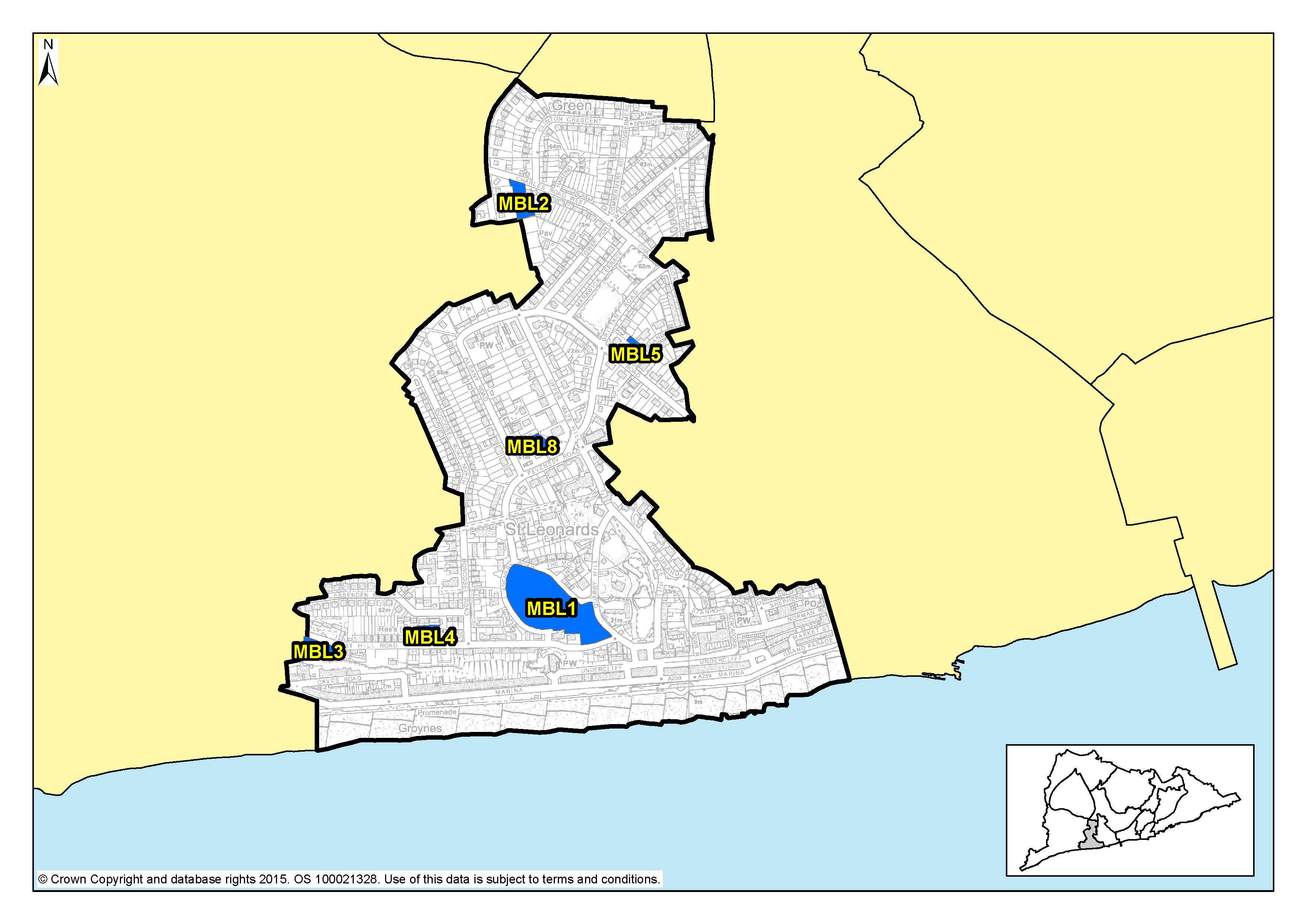
| Site reference | Address | Allocation (including potential number of homes) | Area (ha) | Does the site have a brief in section 5? |
| MBL1 | Former Hastings College, Archery Road | Residential (100) | 2.22 | ✖ |
| MBL2 | 37 Charles Road West, (Former Filsham Nurseries) | Residential (9) | 0.26 | ✖ |
| MBL3 | Gambier House, West Hill Road | Residential (15) | 0.23 | ✔ |
| MBL4 | West Hill Road Reservoir | Residential (14) | 0.19 | ✖ |
| MBL5 | 27 Dane Road | Residential (11) | 0.14 | ✖ |
| MBL8 | Caple Ne Ferne, 2 Albany Road | Residential (8) | 0.18 | ✖ |
Table 8: Residential, mixed use and other allocations for Maze Hill & Burtons’ St Leonards
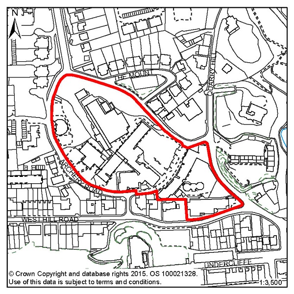
Figure 57: MBL1 – Former Hastings College, Archery Road
Site address: Former Hastings College, Archery Road
Allocated use: Residential
Area: 2.22ha
Possible net capacity: 100
6.177 The redevelopment of site MLB1 – Former Hastings College, Archery Road will remove the existing redundant buildings, provide the opportunity to convert the listed buildings and introduce a new use for the remainder of the site. In terms of the volume and form of future development, key factors that need to be taken into account in any redevelopment proposals include the relationship of any new development to the terrace of listed buildings within the site; the site’s location within St Leonards West Conservation Area; and the potential impact on a number of listed buildings adjacent to the site boundaries and three other adjacent conservation areas. There are also a number of mature shrubs and trees on site that will need to be surveyed for their ecological and arboriculture value, and appropriate conservation and mitigation measures found in relation to them.
6.178 Given the size and location of the site the Council will expect any scheme to support a varied housing mix and may be required to include specific housing for wheelchair users, and affordable housing will also be required as part of the mix. The capacity potential of this site indicates that a Transport Assessment and Travel Plan will be required. Further advice on transport matters is available from East Sussex County Council. As the site is over 1 hectare in size, a Flood Risk Assessment is also required.
Policy MBL1 - Former Hastings College, Archery Road
Former Hastings College, Archery Road is allocated for residential development (possible net capacity 100 dwellings).
Development proposals for this site will:
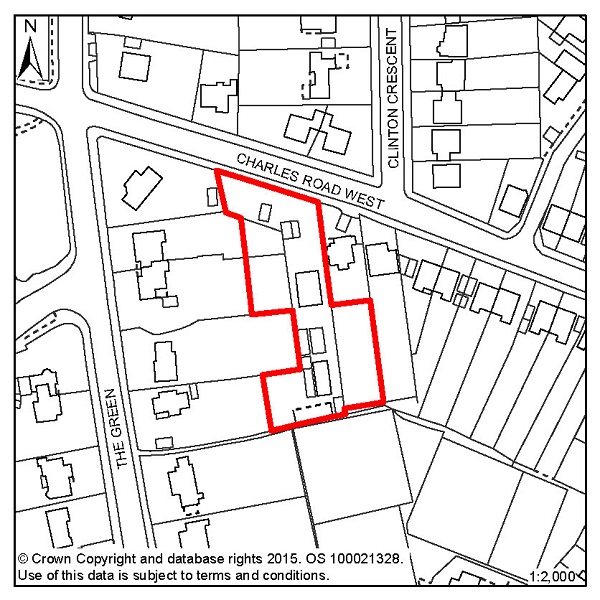
Figure 58: MBL2 – 37 Charles Road West (Former Filsham Nurseries)
Site address: 37 Charles Road West (Former Filsham
Nurseries)
Allocated use: Residential
Area: 0.26ha
Possible net capacity: 9
6.179 Site MBL2 – 37 Charles Road West (Former Filsham Nurseries) is a vacant brownfield site where the former business has ceased to operate. The site is in an existing residential area and offers an appropriate redevelopment opportunity. The capacity potential of this site indicates that a Transport Report will be required. Further advice on transport matters is available from East Sussex County Council.
Policy MBL2 - 37 Charles Road West (Former Filsham Nurseries)
37 Charles Road West (Former Filsham Nurseries) is allocated for residential development (possible net capacity 9 dwellings).
Development proposals for this site will:
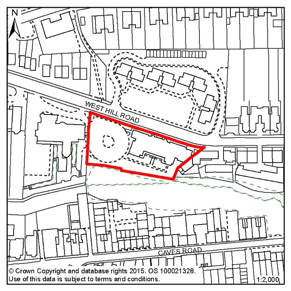
Figure 59: MBL3 – Gambier House, West Hill Road
Site address: Gambier House, West Hill Road
Allocated use: Residential
Area: 0.23ha
Possible net capacity: 15
6.180 Site MBL3 – Gambier House, West Hill Road is a brownfield site, and the existing buildings were vacated by the NHS in July 2011. The site is in a prominent cliff top location that offers a good residential development opportunity.
6.181 The site is located within the Grosvenor Gardens Conservation Area and the retention of the Gambier House building is preferred. Any scheme involving its demolition will need to robustly demonstrate the reasoning behind such a proposal. The site has an existing access point that should be taken advantage of and this is displayed on the design brief for the site, in section 5 of this Plan. The capacity potential of this site indicates that a Transport Report will be required. Further advice on transport matters is available from East Sussex County Council. It is also important that any adverse impacts on the adjacent Local Wildlife Site are avoided.
Policy MBL3 - Gambier House, West Hill Road
Gambier House, West Hill Road is allocated for residential development (possible net capacity 15 dwellings).
Development proposals for this site will:
Additional guidance is also given in a design brief for this site in section 5 of this Plan.
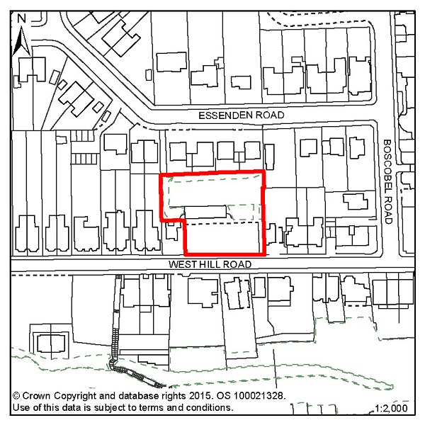
Figure 60: MBL4 – West Hill Road Reservoir
Site address: West Hill Road Reservoir
Allocated use: Residential
Area: 0.19ha
Possible net capacity: 14
6.182 Site MBL4 – West Hill Road Reservoir is a former Water Board site that is roughly rectangular in shape. It is a brownfield site in an existing residential area, which is within the Grosvenor Gardens Conservation Area. The site offers a good redevelopment opportunity. The capacity potential of this site indicates that a Transport Report will be required. Further advice on transport matters is available from East Sussex County Council.
Policy MBL4 - West Hill Road Reservoir
West Hill Road Reservoir is allocated for residential development (possible net capacity 14 dwellings).
Development proposals for this site will:
Figure 61: MBL5 – 27 Dane Road
Site address: 27 Dane Road
Allocated use: Residential
Area: 0.14ha
Possible net capacity: 11
6.183 Site MBL5 – 27 Dane Road is a corner plot in and existing residential area. The site represents a Greenfield development opportunity and it should be should be noted that this site is within the Markwick Terrace Conservation Area. The capacity potential of this site indicates that a Transport Report will be required. Further advice on transport matters is available from East Sussex County Council.
Policy MBL5 - 27 Dane Road
27 Dane Road is allocated for residential development (possible net capacity 11 dwellings).
Development proposals for this site will:
Figure 62: MBL8 – Caple Ne Ferne, 2 Albany Road
Site address: Caple Ne Ferne, 2 Albany Road
Allocated use: Residential
Area: 0.18ha
Possible net capacity: 8
6.184 Site MBL8 – Caple Ne Ferne, 2 Albany Road is the northern extension of a Grade II listed building. The building was last in use as a drug/alcohol rehabilitation treatment centre. The site is in a residential area, in the Markwick Terrace Conservation Area, and represents an opportunity for residential conversion. The capacity potential of this site indicates that a Transport Report will be required. Further advice on transport matters available from East Sussex County Council.
Policy MBL8 - Caple Ne Ferne, 2 Albany Road
Caple Ne Ferne, 2 Albany Road is allocated for residential development (possible net capacity 8 dwellings).
Development proposals for this site will:
< Previous | ^ Top | Next >