
6.1 Policy DS1 of the Planning Strategy sets a target of at least 3400 new homes to meet the housing needs of Hastings between 2011 and 2028. This will not all be new housing allocations, as the total includes homes completed and under construction and existing planning permissions. Planning Strategy Policies FA1, FA2 and FA5 show a broad distribution of the proposed housing land supply. Individual allocated sites are identified in this Development Management Plan.
6.2 Similarly, Policy DS2 of the Planning Strategy identifies a need for the development of up to 70,000m2 of employment floor space in the town between 2008 and 2028.
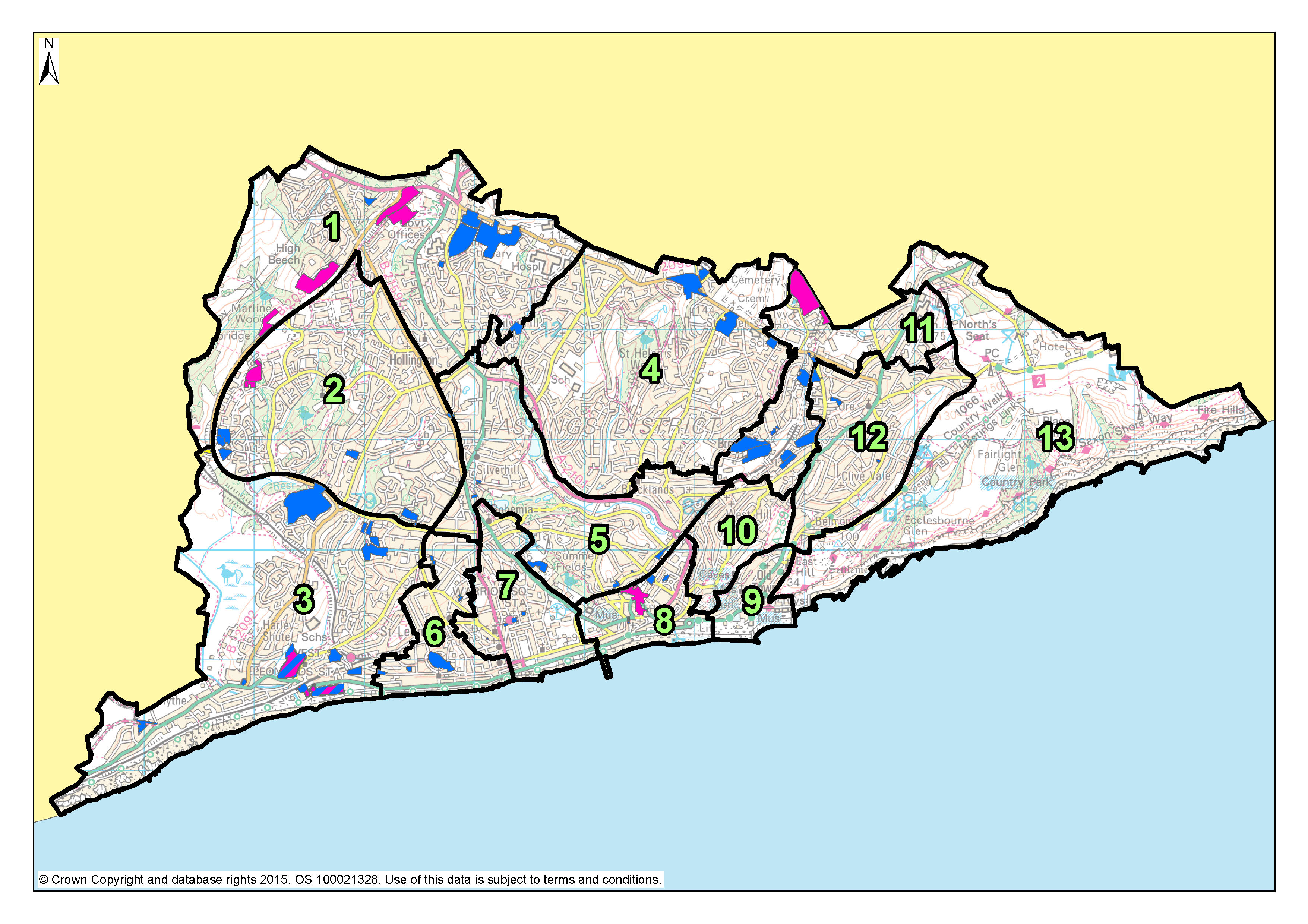
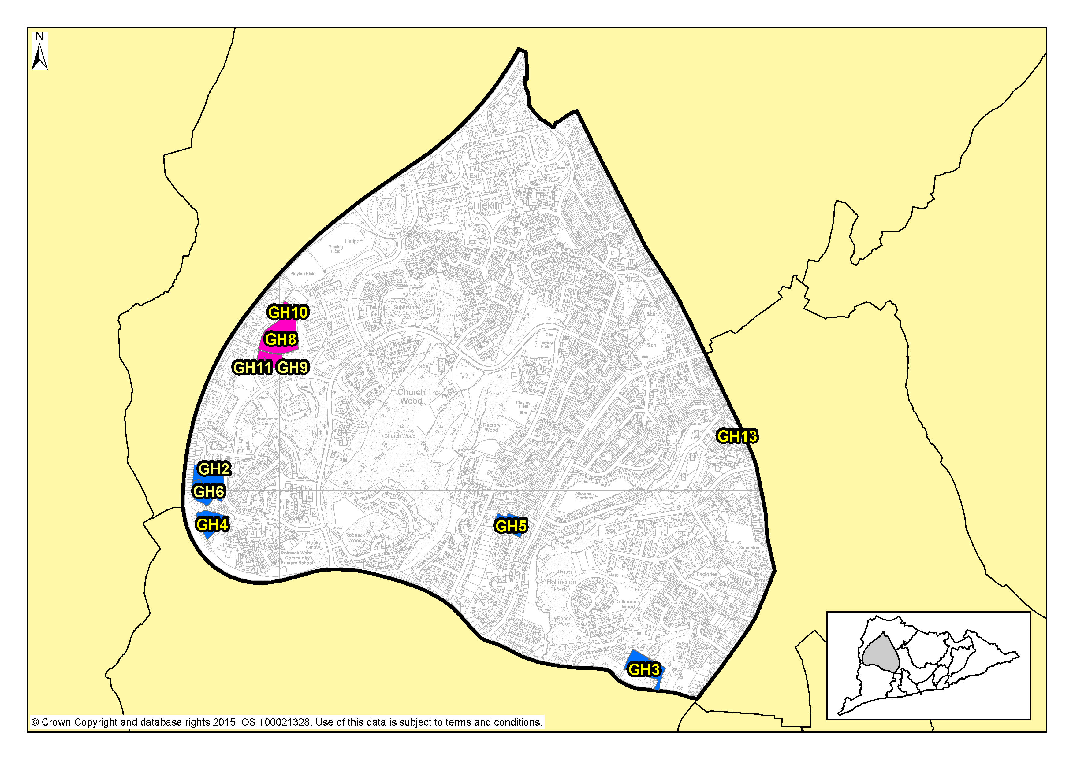
6.3 To provide a local perspective and sense of place, the Planning Strategy also divides the town into 13 Planning Focus Areas. These are areas based upon statistical Super Output Areas and they have an identifiable community or geography or where landscape or function means that they make a logical area for spatial planning. A plan showing the boundaries of the 13 areas is shown over the page.
6.4 For each Planning Focus Area, a description of its main characteristics and the vision for its future is provided. This is then followed by a schedule of the allocated housing and employment sites in each area, together with a small site map and individual site policies. Some larger sites also have a design brief to provide additional guidance and supplement the site policies, set out in section 5 of this Plan.
6.5 Policy LP2 below is an overarching policy to ensure that the sites allocated for development in all Focus Areas reflect the uniqueness and quality of the Borough, taking account of the architectural and natural assets in and around the sites, as well as the area as a whole.
Policy LP2 – Overall Approach to Site Allocations
The number of dwellings set out in the Allocations Policies is purely indicative, showing what might be achieved on each site. Of principal and greater consequence for every scheme, however, will be matters which include design, height, mass, appearance of the proposed building(s), layout (including the provision of a safe and convenient access), trees, biodiversity, green infrastructure and relationship with the surroundings including nearby buildings and views of the Borough's natural and historic assets (including Hastings Castle). These considerations, rather than indicative numbers, will provide the guidelines to secure a development worthy of the site and its surroundings. For development within Conservation Areas, the Council will insist on schemes of distinctive design, quality and character consistent with the statutory requirement to pay special attention to the desirability of preserving or enhancing the character or appearance of the Area. A similar approach will be taken with regard to any scheme which would affect the setting of a Conservation Area. The Council will advise and work with prospective developers from the inception of each scheme to ensure a development of distinction.
© Crown Copyright and database rights [2015]. OS [100021328]. Use of this data is subject to terms and conditions.
Figure 6: The Planning Focus Areas
© Crown Copyright and database rights [2015]. OS [100021328]. Use of this data is subject to terms and conditions.
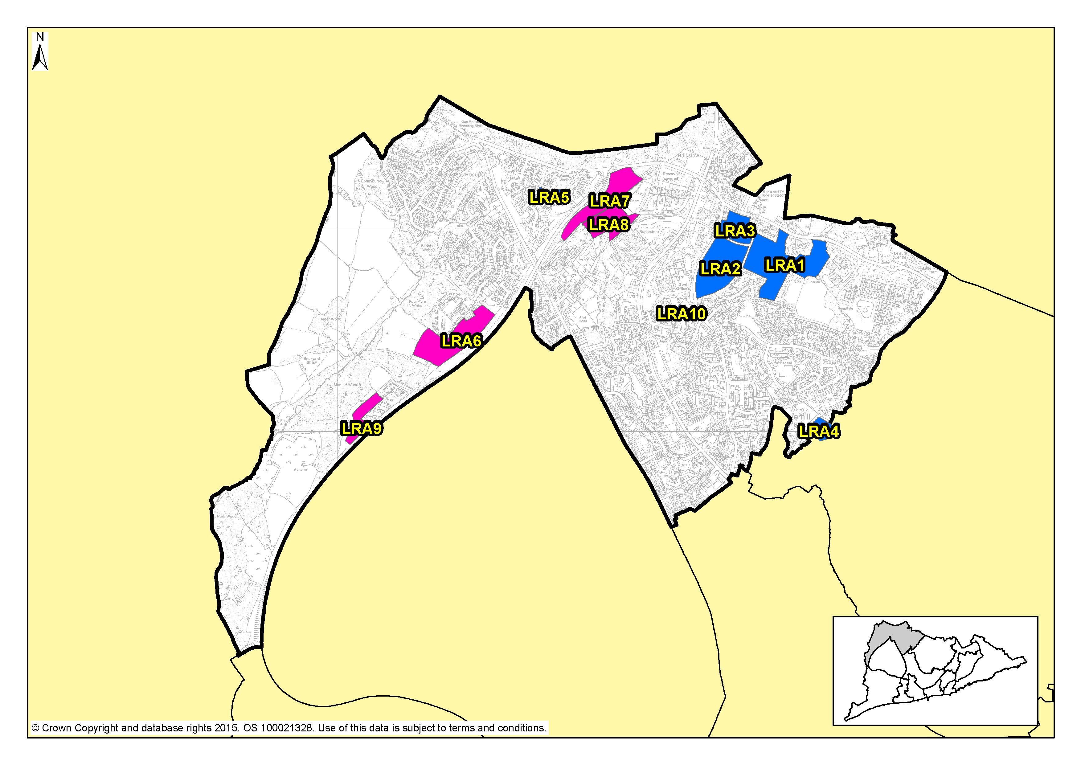
Figure 7: Focus Area 1 - Little Ridge & Ashdown
6.6 This is where Hastings' urban fringe meets the surrounding countryside, with recent housing developments edging into woodland, fields and farmland. It is where visitors to Hastings arriving by road from London get their first glimpse of the sea, with long and often breathtaking views, especially from high points on The Ridge.
6.7 Little Ridge & Ashdown covers the parts of the Borough to the north of Silverhill and west from the Conquest Hospital, including semi-rural areas to the west of Queensway. It is a mixed area, with good quality and well maintained, predominately post-war, housing and two of the town's largest employers: the Conquest Hospital and the Child Support Agency. The area includes a major supermarket whose draw extends well beyond the immediate locality and some other retail outlets. The presence of various employers in the focus area, including tourist accommodation at the Beauport Park holiday village, the Premier Inn and Bannatyne's hotel and spa, and leisure developments, create opportunities for people to live and work in relatively close proximity, and also allows local workers the chance to walk or cycle to work. A mix of housing will help to maintain a vibrant community.
6.8 There are also good public transport connections to the Conquest Hospital, supermarkets, to Hastings Town Centre and beyond. The connectivity allows for a choice of travel options for work and pleasure. This connectivity does, however, come at the cost of some particularly busy roads, and the junctions of the A259, the A21 and The Ridge lie within this area.
6.9 However, Little Ridge & Ashdown is not just a mix of housing and industrial suburbia. There are recreation grounds, allotments, extensive areas of open farmland at the western fringe of the Borough and, most significantly, the Marline Valley, a Site of Special Scientific Interest (SSSI) which includes woodland, meadows and a steep-sided valley covering forty hectares of open space to the west of Queensway.
6.10 Housing in Little Ridge & Ashdown is predominately owner-occupied (according to 2001 Census data over 80% of the residences are owned by their occupants), and most are suburban family homes. The demographic data for the area (again from the 2001 Census), shows an even mix of age groups, reinforcing the fact that this is an area where many families live.
6.11 A major change to this area during the Plan period will be the completion of the Bexhill - Hastings Link Road. This will allow drivers the choice to travel either on Bexhill Road and Hastings seafront, or onto The Ridge to continue their journeys east and west. It will also allow for better and simpler access to the A21 for travel north towards London. Other junction improvements along The Ridge will also be an important part of improved road connections. In addition, the proposed Queensway Gateway Road as well as unlocking the employment sites LRA7 and LRA8, will deliver significant traffic relief, improving the movement and management of traffic along the western section of The Ridge. Whilst the Bexhill - Hastings Link Road will improve transport options for local people, businesses and tourists; careful management of traffic flow, especially at existing major junctions and near potential development sites, will need to be considered. Development proposals all along The Ridge will need to show consideration of the traffic impact onto and off of this locally important traffic route.
6.12 Building the Bexhill - Hastings Link Road will aid in the development of commercial and employment areas along Queensway, particularly at the northern end. Better traffic flow in these areas will help to increase the opportunities for improved access to the sites. This is an opportunity for new commercial developments offering extra employment opportunities, but it should not be to the detriment of ecology, particularly the woodland, of the area.
6.13 Public open spaces are important here in blending the urban area into the surrounding countryside. The Marline Valley SSSI will continue to be protected. Allotments and open spaces are important to local communities and these will be managed and where possible enhanced. Tourist accommodation provision in Little Ridge & Ashdown is something that the Council would also like to see protected and we will consider ways to increase it.
6.14 Policy FA1 of the Planning Strategy states that the provision for 220–280 extra homes is required in Little Ridge & Ashdown up to 2028, and most of these will be delivered through new development on allocated sites. There is a particular development opportunity at Holmhurst St Mary, a former convent school and surrounding grounds, land next to it at 777 The Ridge and the neighbouring former playing field. Together, these sites have the potential to provide a significant number of new homes, with a mix of properties for all, including families, workers for the hospital, and employees of the local light industrial and commercial sites. A benefit of these sites coming forward together in a well phased manner could be to allow for an integrated development, including an improvement to the recreation facilities and the opportunity for the community to take some ownership, and for locally important wildlife habitats and green spaces to be protected and also properly connected
6.15 South of The Ridge West and along Queensway, there are opportunities to increase the volume of industrial and commercial premises and to strengthen the links between the Hastings labour force and the town's exports and the wider market of the UK and beyond. The Bexhill - Hastings Link Road will aid in the continued growth of business and employment in this part of the Borough. Situating these kinds of premises near to one another increases the opportunities for similar businesses to set up and share expertise and knowledge. The new commercial area on Queensway – the Queensway Employment Corridor – with the Enviro 21 Park, an environmentally sustainable industrial park, will act as a catalyst to other businesses and premises. These, and the presence of the Sussex Exchange Business Centre, means that future employment opportunities in this area are strong.
6.16 The eclectic nature of architectural styles in Little Ridge & Ashdown allows for development proposals of all sizes to have a degree of flexibility. There is a need to provide a mixture of tenures in the area where possible, in order to maintain a sustainable community which has access to a range of local shops and services. We will continue to encourage the inclusion of affordable and social housing in schemes, especially in this Focus Area, where there is less provision than elsewhere. Affordable housing, especially for locally employed people, a small amount of flatted development and also some larger family homes will maintain the suburban feel of this area of the Borough, and help to maintain the quality of the built environment.
Site reference |
Address |
Allocation (including potential number of homes) |
Area (ha) |
Does the site have a brief in section 5? |
LRA1 |
Holmhurst St Mary |
Residential (165) |
6.98 |
✔ |
LRA2 |
Harrow Lane Playing Fields |
Residential (140) |
4.75 |
✔ |
LRA3 |
Land adjacent to 777 The Ridge |
Residential (50) |
1.86 |
✔ |
LRA4 |
Old Roar House, Old Roar Road |
Residential (14) |
0.84 |
X |
LRA5 |
Former Workplace Health |
Residential (11)
|
0.47 |
X |
LRA10 |
Land north of Downey Close |
Residential (7) |
0.24 |
X |
Table 1: Residential, mixed use and other allocations for Little Ridge & Ashdown
Site reference |
Address |
Potential gross floorspace (m2) |
Area (ha) |
Does the site have a brief in section 5? |
LRA6 |
Queensway North, Queensway
|
9,700 |
4.70 |
✔ |
LRA7 |
Land at junction of The Ridge West and Queensway |
6,000 |
3.37 |
✔ |
LRA8 |
Land in Whitworth Road, The Ridge West |
6,000 |
2.51 |
✔ |
LRA9 |
Marline Fields, Enviro21 Business Park, Land West of Queensway |
5,600 |
1.48 |
X |
Table 2: Employment allocations for Little Ridge & Ashdown
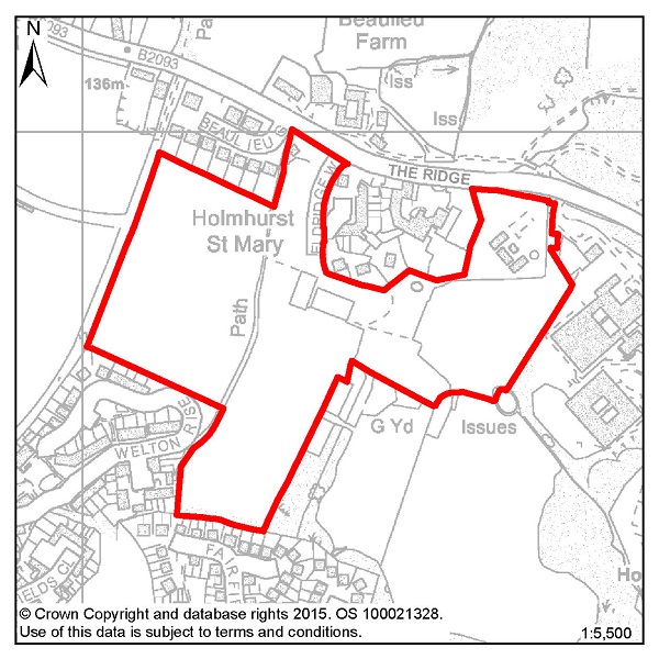
Figure 8: LRA1 - Holmhurst St Mary
Site address: Holmhurst St Mary
Allocated use: Residential
Area: 6.98ha
Possible net capacity: 165
6.17 Site LRA1 – Holmhurst St Mary is a large Greenfield site in the north of the Borough adjacent to The Ridge. The form of any proposed development would need to take into account such matters as the established landscaping, the ecology, the Local Wildlife Site and the position of a Grade II* listed statue (the statue is currently on the English Heritage “at risk” register and will need to be repaired and consolidated as part of any development scheme). There is also a Nun's cemetery on the site and just beyond the northern boundary is the Grade II listed Holmhurst St Mary School.
6.18 Given the size and location of the site the Council will expect any scheme to support a varied housing mix and may be required to include specific housing for wheelchair users, and affordable housing will also be required as part of the mix. The site is also in an identified area that is lacking in quality children's play provision and this may be required within a proposed scheme or a contribution sought to improve a local facility. There is a small area of surface water flood risk on site, which will need to be investigated and mitigated as appropriate. Southern Water has indicated that there is currently insufficient sewerage capacity to serve this site, which will need to be addressed in development proposals. Proposals will also need to show consideration of the transport impact along The Ridge. Further advice on transport matters is available from East Sussex County Council.
6.19 The two neighbouring sites LRA2 and LRA3 give the opportunity for effective planning of greater walking and cycling connectivity, which will contribute to the green infrastructure network. Improved connections between the open and green spaces will support their ecological and recreational value.
6.20 The combination of these three sites and the proximity of the hospital also provide the potential for district heating, so the Council expects the proponents of any scheme on each of the LRA1, LRA2 and LRA3 sites to investigate the feasibility of district heating networks and/or combined heat and power systems.
Policy LRA1 - Holmhurst St Mary
Holmhurst St Mary is allocated for residential development
(possible net capacity 165 dwellings).
Development proposals for this site will:
Additional guidance (that includes opportunities to connect to adjoining sites) is also given in a site design brief in section 5 of this Plan.
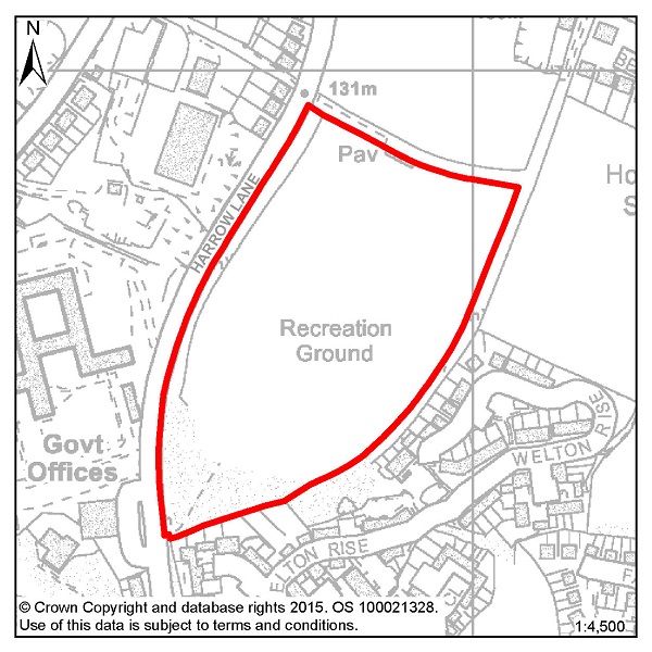
Figure 9: LRA2 - Harrow Lane Playing Fields
Site address: Harrow Lane Playing Fields
Allocated use: Residential
Area: 4.75ha
Possible net capacity: 140
6.21 Site LRA2 – Harrow Lane Playing Fields was protected in the Local Plan 2004 as playing fields. Its use as a site for football fields/active recreation has ceased, and it is now surplus to open space provision requirement. Therefore the Council allocates this site for residential use.
6.22 LRA2 is an elevated site situated above the road and the office and residential area to the east. The boundary of the site is made up of well treed hedgerows, except at the south west corner where there are long views to Beachy Head.
6.23 Given the size and location of the site the Council will expect any scheme to support a varied housing mix and may be required to include specific housing for wheelchair users, and affordable housing will also be required as part of the mix. The site is also in an identified area that is lacking in quality children's play provision and this may be required within a proposed scheme or a contribution sought to improve a local facility. Southern Water has indicated that there is currently insufficient sewerage capacity to serve this site, which will need to be addressed in development proposals. As the site is over 1 hectare in area, a Flood Risk Assessment will be required. This must take into account the risk of surface water flooding, and incorporate mitigation measures as appropriate.
6.24 The development should incorporate measures to help maintain its wooded appearance particularly from Harrow Lane with strengthened boundary planting. There are also public right of way routes running around the perimeter which should be accommodated within any development proposals. Development proposals will need to show consideration of the transport impact along The Ridge. Further advice on transport matters is available from East Sussex County Council.
6.25 The two neighbouring sites LRA1 and LRA3 give the opportunity for effective planning of greater walking and cycling connectivity, which will contribute to the green infrastructure Network. Improved connections between the open and green spaces will support their ecological and recreational value. Of particular importance will be the connectivity to the open space beyond LRA1, as the loss of the existing amenity of the playing fields will be lessened by access to other open space. The combination of these three sites and the proximity of the hospital also provide the potential for district heating.
Policy LRA2 - Harrow Lane Playing Fields
Harrow Lane Playing Fields is allocated for residential development (possible net capacity 140 dwellings).
Development proposals for this site will:
Additional guidance (that includes opportunities to connect to adjoining sites) is also given in a design brief for this site in section 5 of this Plan.
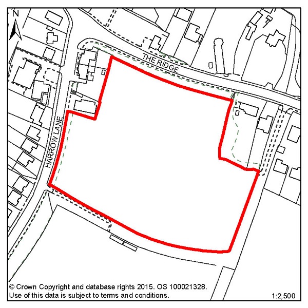
Figure 10: LRA3 – Land adjacent to 777 The Ridge
Site address: Land adjacent to 777 The Ridge
Allocated use: Residential
Area: 1.86ha
Possible net capacity: 50
6.26 Site LRA3 – Land adjacent to 777 The Ridge is a Greenfield site occupying an elevated position at the junction of Harrow Lane with The Ridge. The site does not fall within any landscape designation but the Area of Outstanding Natural Beauty (AONB) lies on the opposite side of The Ridge. There are long views to the north into and out of the AONB, and this is likely to constrain the scale and form of development on this site. Planting on the northern boundary could enable part of the site to be developed but low profile development would be essential on this elevated site. The site is also within an Archaeological Notification Area. Development proposals will need to show consideration of the transport impact along The Ridge. Further advice on transport matters is available from East Sussex County Council.
6.27 The two neighbouring sites LRA1 and LRA2 give the opportunity for effective planning of greater walking and cycling connectivity, which will contribute to the green infrastructure Network. Improved connections between the open and green spaces will support their ecological and recreational value. The combination of these three sites and the proximity of the hospital also provide the potential for district heating. As the site is over 1 hectare in area a Flood Risk Assessment is required.
Policy LRA3 - Land adjacent to 777 The Ridge
Land adjacent to 777 The Ridge is allocated for residential development (possible net capacity 50 dwellings).
Development proposals for this site will:
Additional guidance is also given in a design brief for this site in section 5 of this Plan.
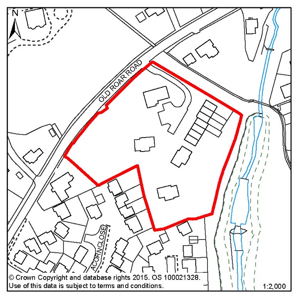
Figure 11: LRA4 – Old Roar House, Old Roar Road
Site address: Old Roar House, Old Roar Road
Allocated use: Residential
Area: 0.84ha
Possible net capacity: 14
6.28 Site LRA4 – Old Roar House, Old Roar Road is a cleared site that was previously a residential children's home. To the south is an area of residential properties and to the east is the northern end of Alexandra Park. There are mature trees on most of the boundaries of the site. The capacity potential of this site indicates that a Transport Report will be required, and further advice is available from East Sussex County Council on this issue.
Policy LRA4 - Old Roar House, Old Roar Road
Old Roar House, Old Roar Road is allocated for residential development (possible net capacity 14 dwellings).
Development proposals for this site will:
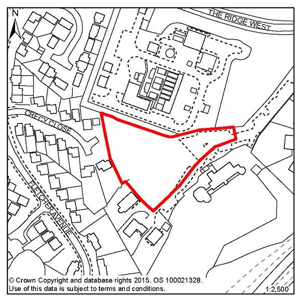
Figure 12: LRA5 – Former Workplace Health & Fitness Centre, The Ridge West
Site address: Former Workplace Health & Fitness
Centre, The Ridge West
Allocated use: Residential
Area: 0.47ha
Possible net capacity: 11
6.29 Site LRA5 – Former Workplace Health & Fitness Centre, The Ridge West is a cleared and vacant site. It is between existing residential development to the west and the Southern Water supply treatment works to the north. To the south is Croft Lodge, a Grade II listed building, set behind a significant screen of vegetation and to the east is further established woodland. The site is also within an Archaeological Notification Area. Development proposals will need to show consideration of the transport impact along The Ridge. Further advice on transport matters is available from East Sussex County Council.
Policy LRA5 - Former Workplace Health & Fitness Centre, The Ridge West
Former Workplace Health & Fitness Centre, The Ridge West is allocated for residential development (possible net capacity 11 dwellings).
Development proposals for this site will:
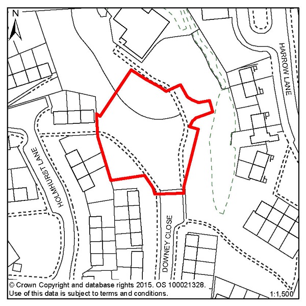
Figure 13: LRA10 – Land north of Downey Close
Site address: Land north of Downey Close
Allocated use: Residential
Area: 0.24ha
Possible net capacity: 7
6.30 Site LRA10 - Land north of Downey Close is a vacant site in a residential area. Building on this site would be a continuation of the existing development pattern. There are footpaths across the site and mature trees adjacent to it; these should be preserved as much as is practicable. The capacity potential of this site indicates that a Transport Report will be required, and further advice is available from East Sussex County Council on this issue.
Policy LRA10 - Land north of Downey Close
Land north of Downey Close is allocated for residential development (possible net capacity 7 dwellings).
Development proposals for this site will:
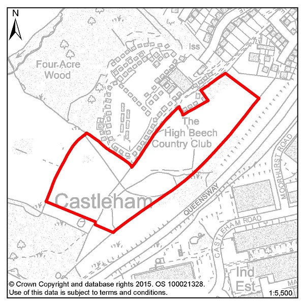
Figure 14: LRA6 – Queensway North, Queensway
Site address: Queensway North, Queensway
Allocated use: Employment; B use classes
Area: 4.70ha
Possible floorspace (gross): 9,700m2
6.31 Site LRA6 – Queensway North, Queensway is allocated for employment use. Its “partner” site, Queensway South, has been partially developed as part of the Enviro21 Business Park scheme and this could form a next phase. It is seen as suitable for high quality business development, possibly for a single large user or more likely for several medium sizes business units or a range of small ones. It has the potential for a total of c. 9,700m2 of floorspace.
6.32 The site adjoins a Site of Special Scientific Interest and any development would need to ensure that there is minimal ecological impact on the protected site, in particular the hydrological effects on drainage into the Marline Valley stream. The site itself is undulating and covered mainly in scrub with some woodland, which should be fully surveyed ecologically to assess what constraints to development these represent. There is also some surface water flood risk on the site.
6.33 There are chalets and residential properties to the west and north of the site and the effect on these should be taken into account in the design, with buffer landscaping where appropriate.
6.34 It is anticipated that the site will be served by a single looped spine road accessed directly off Queensway - with a simple main “T” junction and a secondary “emergency only” junction. Limited improvements to Queensway itself may be required. A pedestrian connection to the adjoining chalet site or the residential area should be considered, in consultation with residents. Development proposals will need to show consideration of the transport impact along The Ridge. Further advice on transport matters is available from East Sussex County Council.
Policy LRA6 - Queensway North, Queensway
Queensway North, Queensway is allocated for employment (B use classes) development (Possible floorspace (gross): 9,700m2).
Development proposals for this site will:
Additional guidance is also given in a design brief for this site in section 5 of this Plan.
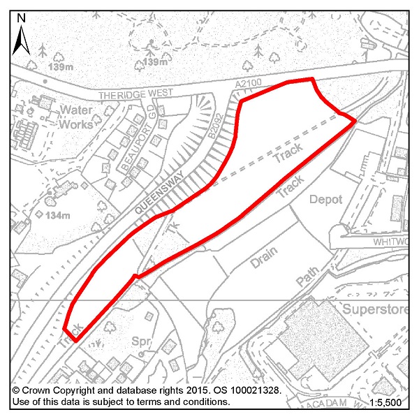
Figure 15: LRA7 – Land at the junction of The Ridge West and Queensway
Site address: Land at the junction of The Ridge West
and Queensway
Allocated use: Employment; B use classes
Area: 3.37ha
Possible floorspace (gross): 6,000m2.
If combined with site LRA8: up to 12,000m2
6.35 Site LRA7 – Land at junction of The Ridge West and Queensway is a greenfield site in the ownership of East Sussex County Council.
6.36 Taken together with an adjoining employment allocation, site LRA8, this location would offer the potential to create a high quality employment estate with a prominent frontage onto The Ridge, a key corridor in the local road network once the Bexhill-Hastings Link Road is open, which would considerably assist its commercial potential. The two sites combined have an area of 5.88ha and a potential capacity of up to 12,000m2.
6.37 Road infrastructure will be required for the release of these sites LRA7 and LRA8. Access could be from Queensway or from the roundabout to the north west of the site. To promote the usability of both of the sites access between them will also be required. Development proposals will need to show consideration of the transport impact along The Ridge. Further advice on transport matters is available from East Sussex County Council.
6.38 The site itself is gently sloping although there is a more marked level difference where it joins site LRA8. It is mainly open grassland but it contains some woodland and is surrounded by belts of trees. An ecological and landscape survey would be required to assess the extent to which these factors would constrain development. As the site is over 1 hectare in area a Flood Risk Assessment is required.
Policy LRA7 - Land at the junction of The Ridge West and Queensway
Land at the junction of The Ridge West and Queensway is allocated for employment (B use classes) development (Possible floorspace (gross): 6,000m2).
Development proposals for this site will:
Additional guidance is also given in a design brief for this site in section 5 of this Plan.
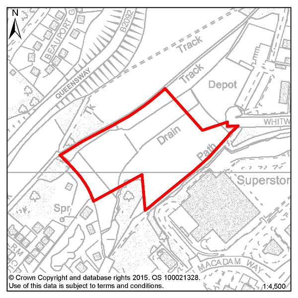
Figure 16: LRA8 – Land in Whitworth Road, The Ridge West
Site address: Land in Whitworth Road, The Ridge West
Allocated use: Employment; B use classes
Area: 2.51ha
Possible floorspace (gross): 6,000m2.
If combined with site LRA7: up to 12,000m2
6.39 Site LRA8 – Land in Whitworth Road, The Ridge West is capable of being brought forward as an extension of the West Ridge employment area. Developed in this form, access may be possible by means of an extension of Whitworth Road (subject to some widening) or, alternatively, John Macadam Way to the south was constructed in a form which would allow it to be extended into the site to provide access. To promote the usability of both of the sites, LRA7 and LRA8, access between them will also be required. Development proposals will need to show consideration of the transport impact along The Ridge. Further advice on transport matters is available from East Sussex County Council. The Council will work with East Sussex County Council to deliver improvements to the local highway network (in particular the connection between The Ridge junction and the Bexhill-Hastings Link Road) in accordance with the Hastings Planning Strategy Policy T2 on this site.
6.40 The site falls within a Local Wildlife Site; it is located at the head of a shallow valley formed by the Hollington Stream and it is partially wooded. A full ecological survey and a landscape assessment will be required to assess the extent to which these factors would constrain any development. The floorspace achievable on this site could be affected by the findings of this work.
6.41 This site adjoins site LRA7 to the north. Combined, these sites would have capacity to enable the creation of a high quality employment estate with direct frontage onto The Ridge, and which would considerably enhance its commercial potential.
6.42 A small part of this site is affected by Flood Zone 3. A Flood Risk Assessment will therefore be required with any proposals and measures to reduce surface water flood risk, such as Sustainable Drainage Systems (SUDs).
Policy LRA8 - Land in Whitworth Road, The Ridge West
Land in Whitworth Road, The Ridge West is allocated for employment (B use classes) development (Possible floorspace (gross): 6,000m2).
Development proposals for this site will:
Additional guidance is also given in a design brief for this site in section 5 of this Plan.
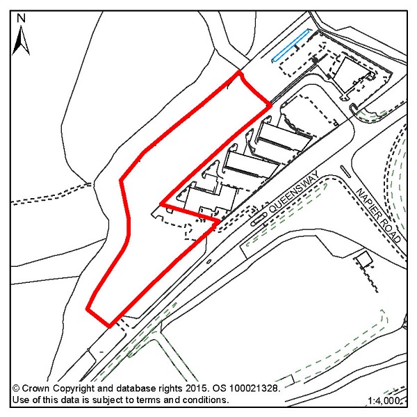
Figure 17: LRA9 – Marline Fields, Enviro21 Business Park, Land west of Queensway
Site address: Marline Fields, Enviro21 Business Park,
Land west of Queensway
Allocated use: Employment; B use classes
Area: 1.48ha
Possible floorspace (gross): 5,600m2
6.43 Site LRA9 – Marline Fields, Enviro21 Business Park, Land west of Queensway has the capacity for approximately 5,600m2 of business floor space and is part of a larger site. Four high quality business units and the access spine road have already been constructed under the Enviro21 Business Park scheme. The plots themselves are cleared and prepared. It is therefore effectively a serviced site ready for development, either under the existing planning permission or through a fresh design.
6.44 The site adjoins a Site of Special Scientific Interest and any development would need to ensure that there is minimal ecological impact on the protected site, in particular the hydrological effects on drainage into the Marline Valley stream. Due to the size of the site, a Flood Risk Assessment will be required. This must take into account the risk of surface water flooding, and incorporate mitigation measures as appropriate. Development proposals will need to show consideration of the transport impact along The Ridge. Further advice on transport matters is available from East Sussex County Council.
Policy LRA9 - Marline Fields, Enviro21 Business Park, Land West of Queensway
Marline Fields, Enviro21 Business Park, Land West of Queensway is allocated for employment (B use classes) development (Possible floorspace (gross): 5,600m2).
Development proposals for this site will:
© Crown Copyright and database rights [2015]. OS [100021328]. Use of this data is subject to terms and conditions.
Figure 18: Focus Area 2 – Greater Hollington
6.45 Lying outside of the main town centres, this Planning Focus Area includes a broad mix of different characteristics and uses, covering housing, factory estates, retail and protected open space. Bordered by Battle Road in the east and the sweeping curve of Queensway in the west, it extends from the Asda superstore at Silverhill to open countryside on the western edges of town.
6.46 The majority of housing here is post-war, with the Four Courts (Hastings' only dedicated housing tower blocks) forming a very striking part of the townscape. But there are few flats otherwise. A lot of the housing is family houses with gardens. Much of the housing in this Focus Area is the product of extensive urban growth and expansion projects of the last 30 years. There are, however, occasional pockets of older pre-war cottages that once stood in villages, before Hastings Borough extended across them.
6.47 There are 3 major industrial estates here: Castleham, Churchfields, and Ponswood. These are well-used and provide a significant contribution to local employment, with employers such as General Dynamics, Marshall Tufflex and Deutsch. The town's largest single retail store is here too, the Tesco Extra superstore on Church Wood Drive. The area is reasonably well served by local convenience stores, has doctors' surgeries, and community centres.
6.48 But Greater Hollington is not an unending suburban sprawl of housing and factory estates. There are plenty of open spaces here, and some of the most important ecological habitats in town, notably at Church Wood and the neighbouring Robsack Wood nature reserves. Walking through these ancient woodlands, it feels as though you're far out in the countryside, not a few hundred metres from shops and factories.
6.49 Even outside of these nature reserves, Greater Hollington has an open, spacious feel. There's Hollington Park (comprising Ponds Wood and Gillsman's Wood), and many smaller open spaces, allotments, playing fields, and houses with gardens. This sense of space might, though, be somewhat misleading as the population density is relatively high at 68 people per hectare (according to 2001 Census data).
6.50 This Focus Area has the second highest population of the 13, with a high proportion of families with children. Census data shows that more than a fifth of the population are children under 16, and this is possibly indicative of this area being the third highest for the proportion of families with children. There is significant economic deprivation here also. It is the fourth most deprived area of the Borough, with a quarter of the adult population on out-of-work benefits (according to the Department of Work and Pensions – Nomis statistics); more than a third of the children live in families with incomes below the official UK poverty level (Office of National Statistics) and nearly 50% of houses are social rented.
6.51 So this is an area of contrasts: successful businesses and unemployment; high-rise housing and bungalows; factory estates and nature reserves.
6.52 We want Greater Hollington to retain its open, spacious environment while remaining as one of the principal employment areas of the town. To achieve this, it will be essential to retain the protected open spaces, parks, allotments and nature reserves between housing and factory estates.
6.53 The architectural heritage of Greater Hollington is rooted in the expansion of Hastings Borough during the second half of the 20th century, and particularly during the last 30 years. So whilst an appreciation of the built environment in this area is important, there are particular opportunities for innovative development here. Policy FA1 of the Planning Strategy sets out a need to plan for 250-310 new homes to be built in this area up to 2028; there is the scope to provide a range of housing types and tenures with a mix of family homes with gardens, and smaller residences for single people and couples. Schemes for development in Greater Hollington should reflect the spacious feel of the surrounding area and a particular aspect of this should be good design with a focus on environmental efficiency that minimises fuel costs.
6.54 We would especially welcome applications to renovate or redevelop industrial premises, especially in ways that minimise energy consumption and protect natural resources. More retail premises could also be considered, although not big, out-of-town retail supermarkets – rather, smaller shops that serve a more local community. And we would consider proposals to blend the currently quite rigid boundaries between industrial and residential areas, with the possibility of small, modern workshops mixed in with housing, and possibly live/work units. We would not, however, want to see the space allocated for employment purposes in the area reduce overall. Increasing the opportunities for employment is one way to help reduce the numbers of people on out of work benefits.
6.55 Development in Greater Hollington should be attractive, imaginative, and environmentally sustainable. We want to see the area develop as an environmental showcase of innovative design, blending housing and industrial uses into the natural green spaces that will continue to be at the heart of its communities.
| Site reference | Address | Allocation (including potential number of homes) | Area (ha) | Does the site have a brief in section 5? |
| GH2 | Mayfield E, Bodiam Drive | Residential (37) | 1.10 | ✔ |
| GH3 | Spyways School, Gillsmans Hill | Residential (33) | 1.05 | X |
| GH4 | Mayfield J, Mayfield Lane | Residential (36) | 0.77 | X |
| GH5 | Land at Redgeland Rise (Former Wishing Tree Nursery) | Residential (28) | 0.71 | X |
| GH6 | Mayfield Farm | Residential (8) | 0.54 | X |
| GH13 | 133 Battle Road (Former Tivoli Tavern) | Residential (11) | 0.10 | X |
Table 3: Residential, mixed use and other allocations for Greater Hollington
| Site reference | Address | Potential gross floorspace (m2) | Area (ha) | Does the site have a brief in section 5? |
| GH8 | Sites PX and QX, Churchfields | 6,900 | 1.61 | ✔ |
| GH9 | Site NX2, Sidney Little Road, Churchfields | 770 | 0.32 | ✔ |
| GH10 | Site RX2, Sidney Little Road, Churchfields | 910 | 0.22 | ✔ |
| GH11 | Site NX3, Sidney Little Road, Churchfields | 920 | 0.17 | ✔ |
Table 4: Employment allocations for Greater Hollington
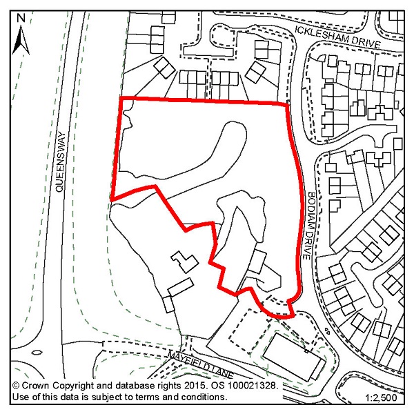
Figure 19: GH2 – Mayfield E, Bodiam Drive
Site address: Mayfield E, Bodiam Drive
Allocated use: Residential
Area: 1.10ha
Possible net capacity: 37
6.56 Site GH2 – Mayfield E, Bodiam Drive is a gently sloping site at the edge of an existing residential area, and there is the potential for this site to accommodate at least 37 dwellings. There are opportunities to connect this site to the one directly to its south, GH6 - Mayfield Farm, Mayfield Lane. This could be by road or footpath and would aid permeability, making it easier for people to travel to and from their homes. There is also a good opportunity to include an access footpath to the existing bus stop on Bodiam Drive at the north-east corner of the site.
6.57 Landscaping and potentially noise screening (hedging for example), is likely to be required along the western border of the site to shield the development from the Queensway road. The capacity potential of this site indicates that a Transport Statement will be required, further advice is available from East Sussex County Council. Any development on this site could potentially affect the setting of Mayfield Farmhouse; a Grade II listed building that is sited immediately to the south-west of the site. Due to the size of the site, a Flood Risk Assessment is required.
Policy GH2 - Mayfield E, Bodiam Drive
Mayfield E, Bodiam Drive is allocated for residential development (possible net capacity 37 dwellings).
Development proposals for this site will:
Additional guidance is also given in a design brief for this site in section 5 of this Plan.
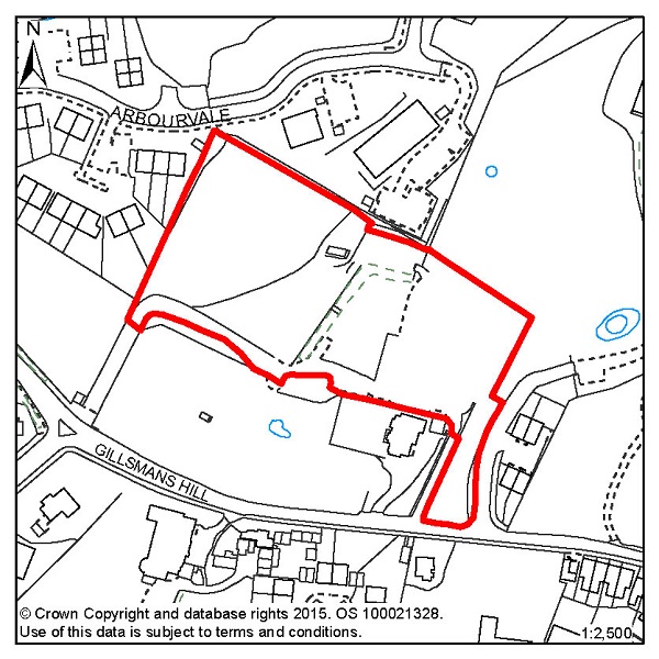
Figure 20: GH3 – Spyways School, Gillsmans Hill
Site address: Spyways School, Gillsmans Hill
Allocated use: Residential
Area: 1.05ha
Possible net capacity: 33
6.58 Site GH3 – Spyways School, Gillsmans Hill is a sloping site from east to west, the west adjoins an existing residential development. The neighbouring residences to the west are bungalows that are largely screened by mature trees. There are a number of protected trees on and adjacent to the site and there is also a Local Wildlife Site that overlaps the area. Due to the size of the site, a Flood Risk Assessment is required. The capacity potential of this site indicates that a Transport Report will also be required. Further advice on transport matters is available from East Sussex County Council.
Policy GH3 - Spyways School, Gillsmans Hill
Spyways School, Gillsmans Hill is allocated for residential development (possible net capacity 33 dwellings).
Development proposals for this site will:
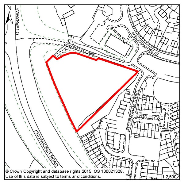
Figure 21: GH4 – Mayfield J, Mayfield Lane
Site address: Mayfield J, Mayfield Lane
Allocated use: Residential
Area: 0.77ha
Possible net capacity: 36
6.59 Site GH4 – Mayfield J, Mayfield Lane is a roughly triangular shaped site between existing residential development and the Queensway road. Formerly part of Mayfield farm it has a well-defined boundary of mature vegetation. The capacity potential of this site indicates that a Transport Statement will be required. Further advice on transport matters is available from East Sussex County Council.
Policy GH4 - Mayfield J, Mayfield Lane
Mayfield J, Mayfield Lane is allocated for residential development (possible net capacity 36 dwellings).
Development proposals for this site will:
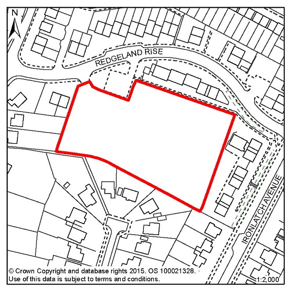
Figure 22: GH5 – Land at Redgeland Rise (Former Wishing Tree Nursery)
Site address :Land at Redgeland Rise
(Former Wishing Tree Nursery)
Allocated use: Residential
Area: 0.71ha
Possible net capacity: 28
6.60 Site GH5 – Land at Redgeland Rise (Former Wishing Tree Nursery) was previously occupied by Hastings Borough Council's nursery. The site slopes down from west to east. There are a number of trees with Tree Preservation Orders (TPO's) sited on the western, southern and eastern boundaries, but there is no screening to the north of the site where the flats in Redgeland Rise (Farren Court) face the site. The development to the east in Ironlatch Avenue is at a lower level and to the south of the site are bungalows in Church Wood Way.
6.61 Redgeland Rise is located between designated ecological areas at Hollington Park and Church Wood and there are a number of large gardens to the south of site GH5. It is likely that there will be particular species on site that will need to be carefully managed and other conservation and mitigation measures might be required. The capacity potential of this site indicates that a Transport Report will be required. Further advice on transport matters is available from East Sussex County Council.
Policy GH5 - Land at Redgeland Rise (Former Wishing Tree Nursery)
Land at Redgeland Rise (Former Wishing Tree Nursery) is allocated for residential development (possible net capacity 28 dwellings).
Development proposals for this site will:
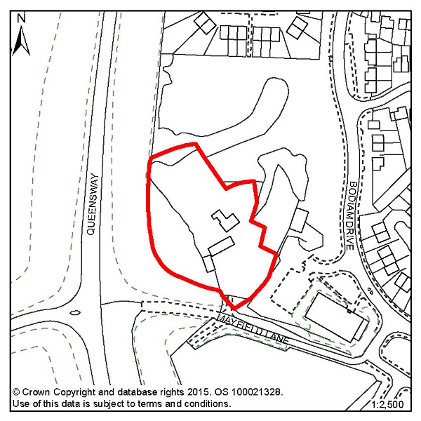
Figure 23: GH6 – Mayfield Farm, Mayfield Lane
Site address: Mayfield Farm, Mayfield Lane
Allocated use: Residential
Area: 0.54ha
Possible net capacity: 8
6.62 Site GH6 – Mayfield Farm, Mayfield Lane is a gently sloping site at the edge of an existing residential area. There is the potential for this site to accommodate about 8 dwellings. Mayfield Farmhouse, a Grade II listed building, is in the centre of this site. Any new development will need to sustain and enhance the setting of the farmhouse.
6.63 The site is adjacent to site GH2 – Mayfield E, Bodiam Drive, which has a design brief (see section 5 of this Plan) that indicates that there are opportunities to connect the two sites, and this should be examined and referenced within any schemes proposed for site GH6.
6.64 New residential development is likely to require the improvement of Mayfield Lane to ensure safe access to the site. Transport management will need to be balanced against the impact of any works on the historic approach to the farmhouse. The capacity potential of this site indicates that a Transport Report will be required. Further advice on transport matters is available from East Sussex County Council. The nearby Landfill site may also mean that land contamination needs to be investigated.
Policy GH6 - Mayfield Farm, Mayfield Lane
Mayfield Farm is allocated for residential development (possible net capacity 8 dwellings).
Development proposals for this site will:
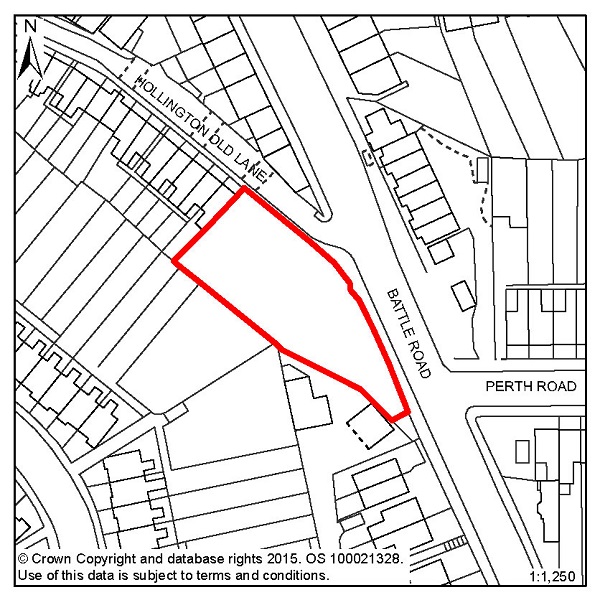
Figure 24: GH13 – 133 Battle Road (Former Tivoli Tavern)
Site address: 133 Battle Road (Former Tivoli Tavern)
Allocated use: Residential
Area: 0.10ha
Possible net capacity: 11
6.66 Site GH13 – 133 Battle Road (Former Tivoli Tavern) offers a redevelopment opportunity for residential use. The site is adjacent to Battle Road and so access to this road will need to be given particular attention for the reasons of safety. The capacity potential of this site indicates that a Transport Report will be required. Further advice on transport matters is available from East Sussex County Council.
Policy GH13 – 133 Battle Road (Former Tivoli Tavern)
133 Battle Road (Former Tivoli Tavern) is allocated for residential development (possible net capacity 11 dwellings).
Development proposals for this site will:
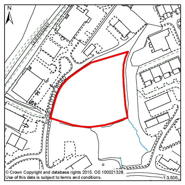
Figure 25: GH8 – Sites PX and QX, Churchfields
Site address: Sites PX and QX, Churchfields
Allocated use: Employment; B use classes
Area: 1.61ha
Potential floorspace (gross): 6,900m2
6.67 Site GH8 – PX and QX, Churchfields is the largest undeveloped site on the Churchfields Employment Estate.
6.68 This is a sloping site that is largely open, but overgrown with scrub. It is capable of accommodating a single large occupier or, more easily given the topography, several medium sizes units. The long frontage onto Sidney Little Road allows a choice of possible access points.
6.69 Trees along the southern and eastern boundaries should be safeguarded. An ecological survey of the site will be required prior to redevelopment to establish if any protected species are present. The capacity potential of this site indicates that a Transport Assessment and Travel Plan will be required. Further advice on transport matters is available from East Sussex County Council.
Policy GH8 - Sites PX and QX, Churchfields
PX and QX, Churchfields is allocated for employment (B use classes) development (Possible floorspace (gross): 6,900m2).
Development proposals for this site will:
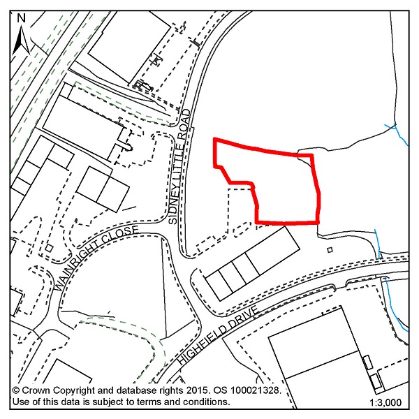
Figure 26: GH9 – Site NX2, Sidney Little Road, Churchfields
Site address: Site NX2, Sidney Little Road, Churchfields
Allocated use: Employment; B use classes
Area: 0.32ha
Potential floorspace (gross): 770m2
6.70 Site GH9 – NX2 Sidney Little Road, Churchfields is one of a group of three small development plots. The first, NX1 immediately to the south, was developed as a row of small business units. The existing access off Sidney Little Road is configured to serve both the existing units and those still to be built on this site, NX2, and on site NX3. This sloping site has well established vegetation on and along its northern edge, which should be retained where practical. As with NX1, the site is suited to a group of small units. The capacity potential of this site indicates that a Transport Report will be required. Further advice on transport matters is available from East Sussex County Council.
Policy GH9 - Site NX2, Sidney Little Road, Churchfields
Site NX2 Sidney Little Road, Churchfields is allocated for employment (B use classes) development (Possible floorspace (gross): 770m2).
Development proposals for this site will:
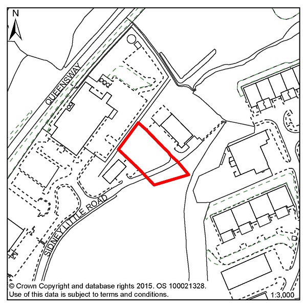
Figure 27: GH10 – Site RX2, Sidney Little Road, Churchfields
Site address: Site RX2, Sidney Little Road, Churchfields
Allocated use: Employment; B use classes
Area: 0.22ha
Potential floorspace (gross): 910m2
6.71 Site GH10 – RX2, Sidney Little Road, Churchfields is a small open site that is the remaining plot of a group of three - the other two having been developed as small/medium business units some time ago.
6.72 A business unit similar in scale to those existing will be acceptable and a shared access with the unit to the north- east would be the most space efficient arrangement. The capacity potential of this site indicates that a Transport Report will be required. Further advice on transport matters is available from East Sussex County Council.
Policy GH10 - Site RX2, Sidney Little Road, Churchfields
Site RX2, Sidney Little Road, Churchfields is allocated for employment (B use classes) development (Possible floorspace (gross): 910m2).
Development proposals for this site will:
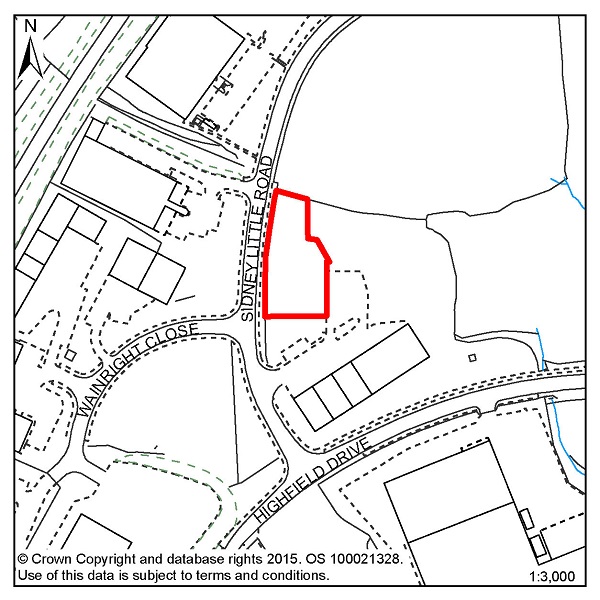
Figure 28: GH11 – Site NX3, Sidney Little Road, Churchfields
Site address: Site NX3, Sidney Little Road, Churchfields
Allocated use: Employment; B use classes
Area: 0.17ha
Potential floorspace (gross): 920m2
6.73 Site GH11 – NX3 Sidney Little Road, Churchfields is one of a group of three small development plots. The first, NX1 immediately to the south, was developed as a row of small business units. The existing access off Sidney Little Road is configured to serve the existing units, site NX2 and this site, NX3. This sloping site has well established vegetation on and along its northern edge, which should be retained where practical. As with NX1, the site is suited to a group of small units. The capacity potential of this site indicates that a Transport Report will be required. Further advice on transport matters is available from East Sussex County Council.
Policy GH11 - Site NX3, Sidney Little Road, Churchfields
NX3 Sidney Little Road, Churchfields is allocated for employment (B use classes) development (Possible floorspace (gross): 920m2).
Development proposals for this site will:
< Previous | ^ Top | Next >