
Affordable housing [H2] – housing for sale or rent, for those whose needs are not met by the market. A full definition is given in Annex 2 of National Planning Policy Framework 2021.
Area of Outstanding Natural Beauty (AONB) [4.1] – land protected under the Countryside and Rights of Way Act 2000 to conserve and enhance the natural beauty of the area.
Asset of Community Value (ACV) – a building or land that has recently, or is presently, used to further the social wellbeing and social interest of the local community and could do so in the future.
Basic Conditions Statement [1.1] – a separate document appraising the extent to which the neighbourhood plan policies conform with the NPPF , the strategic policies of the West Dorset District Plan and EU guidance on sustainability.
Community and Leisure Services and Facilities [6] - a wide ranging definition including shops, cafes, restaurants and public houses, pre-schools and schools, health and social care facilities, community halls/hubs, including places of worship, sports and leisure facilities such as play areas and recreation grounds. These are local facilities whose main catchment population would be the Neighbourhood Plan area and adjoining parishes.
Conservation Area [4.3 ] – an area of special architectural or historic interest, the character and appearance of which are preserved and enhanced by local planning policies and guidance.
Consultation Summary – a separate document summarising the consultation process on the Neighbourhood Plan.
Defined Development Boundary (DDB) [2.2.6, 7.11] – the area within which suitable development is generally allowed and outside which development is restricted.
Development Plan [1.6] – documents setting out the local planning authority’s policies and proposals for the development and use of land in the area.
Housing Needs Assessment [7.1] – an assessment of housing needs during the plan period.
Independent Examiner [1.5 ] - an independent person appointed to carry out an examination of a proposed neighbourhood plan to ensure that the basic conditions are met (see Basic Conditions Statement above).
Land of Local Landscape Importance [4.9 ] – land designated as such in the 2015 Local Plan and listed in Table 3.
Listed Building – any building or structure which is included as a building of special architectural or historic interest on the National Heritage List for England.
Local Green Space [EN4] – an area or open space of particular importance listed in Table 3 which is protected from development.
Local Plan [7.2] – documents prepared by a local planning authority setting out the strategic priorities for the use and development of land including transport infrastructure and the protection for the local environment.
Local Planning Authority (LPA) [1.5,1.3] – the local government body responsible for formulating planning policies and controlling development which, in this area, is Dorset Council.
Local Referendum [1.6] – a direct vote in which the local community will be asked to accept or reject the neighbourhood plan.
National Planning Policy Framework (NPPF) [1.1] – a government policy document (at the time of drafting this plan, last updated in July 2021) setting out the government’s planning policies for England and how these should be applied.
Neighbourhood Plan [1.1.1, 4.2] – a planning document initiated by the parish council and prepared by the local community setting out the vision for the area and policies for the development and use of land and for the protection of the environment.
National Heritage List for England (NHLE) [4.4] – see definition of listed building.
Parish Council [1.1.5] – the Yetminster and Ryme Intrinseca Parish Council which covers the two civil parishes of Yetminster and Ryme Intrinseca.
Parish Plan [1.2] – the plan produced by the Parish Council in 2015 that sets out a vision for the future of the parish community and outlines how that can be achieved in an action plan.
Projects [1.4] – a list of projects, contained in Appendix B, which cannot be delivered through the planning system but which reflect the aspirations of the community.
Steering Group [1.2] – the group of volunteers which has helped prepare the Neighbourhood Plan.
Strategic Environmental Assessment – a systematic process aiming to ensure that environmental considerations are fully considered in the preparation of the neighbourhood plan.
Strategic Housing Land Availability Assessment (SHLAA) [7.7] – a periodic assessment by Dorset Council of the availability of land for housing.
Sustainable Development [1.1.2] – development that meets the needs of the present without compromising the ability of future generations to meet their own needs.
Vision [3] – the basis for defining objectives, policies and projects and set out in section 3.
This appendix provides a list of the main evidence documents used in the formulation of this Neighbourhood Plan. Additional documents also considered during the preparation of this plan are included in the Statement of Evidence.
2011 Strategic Housing Market Assessment for the Dorchester / Weymouth Housing Market Area, January 2012, Justin Gardner Consulting (JGC) and Chris Broughton Associates (CBA) Microsoft Word - West Dorset - LA report.doc (dorsetcouncil.gov.uk)
Basic Conditions Statement, June 2021, prepared for Yetminster & Ryme Intrinseca Parish Council by Dorset Planning Consultant Limited Basic Conditions Statement Submission YRINP 210619.pdf - Google Drive
Bournemouth, Dorset and Poole Workspace Strategy, October 2016, Dorset Councils Bournemouth, Dorset and Poole Workspace Strategy and Study - Dorset Council
Bournemouth, Poole and Dorset Residential Car Parking Study, 2011, Microsoft Word - 2010-05-07 Draft DRCPS Vol.1 v.22.doc (dorsetcouncil.gov.uk)
Consultation Statement, July 2021, Yetminster & Ryme Intrinseca Neighbourhood Plan Group Consultation Statement YRINP ver 8 210714 (1).pdf - Google Drive
Designing with Downsizers, October 2016, University of Sheffield and DWELL https://www.housinglin.org.uk/_assets/DWELL_DesigningWithDownsizers.pdf
Dorset’s Ecological Networks https://dorsetlnp.org.uk/dorsets-ecological-networks/
Ecology Report & Field Survey, March 2019, Dorset Environmental Records Dorset Environmental Records Centre (Ecological Assessment) YRINP March 2019 (1).pdf - Google Drive
Employment Land Review for West Dorset & Weymouth & Portland – Northern Area, 2013, West Dorset District Council and Weymouth & Portland Borough Council 618fb0a9-6f87-86f7-8348-1cf3777f4db4 (dorsetcouncil.gov.uk)
Heritage Impact Assessment for the Yetminster & Ryme Intrinseca Neighbourhood Plan, June 2021, AECOM Heritage Impact Assessment YRINP AECOM Final 210602.pdf - Google Drive
Housing Needs Assessment, March 2018 & updated June 2021, Yetminster & Ryme Intrinseca Neighbourhood Plan Group Housing Needs Assessment YRINP 2106 RevF.pdf - Google Drive
Local Area Reports (2011 Census) for Yetminster and Ryme Intrinseca, Nomis https://www.nomisweb.co.uk/reports/localarea?compare=E04003629 and https://www.nomisweb.co.uk/reports/localarea?compare=E04003590
National Heritage List for England https://historicengland.org.uk/listing/the-list/
National Planning Policy Framework and relevant planning practice guidance https://www.gov.uk/government/collections/planning-practice-guidance
Site Assessment Report for the Yetminster & Ryme Intrinseca Neighbourhood Plan, March 2019, AECOM Site Assessment Report YRINP Final AECOM 190605 (1) (1).pdf - Google Drive
Strategic Environmental Assessment for the Yetminster & Ryme Intrinseca Neighbourhood Plan - Environmental Report August 2020, prepared for Yetminster & Ryme Intrinseca Parish Council by Dorset Planning Consultant Limited SEA Environmental Report - submission update - YRINP 210618.pdf - Google Drive
Traffic in Villages - Safety and Civility for Rural Roads, A toolkit for communities, 2011, produced by the Dorset AONB Partnership in conjunction with Hamilton-Baillie Associates TrafficInVillages.pdf (northwessexdowns.org.uk)
West Dorset Landscape Character Assessment, February 2009, West Dorset District Council LCA Feb 2009 Final version 2.qxd (dorsetcouncil.gov.uk)
West Dorset, Weymouth & Portland Local Plan, October 2015, jointly prepared and adopted by West Dorset District Council and Weymouth & Portland Borough Council West Dorset, Weymouth & Portland adopted local plan - Dorset Council
Yetminster & Ryme Intrinseca Parish Plan, April 2015, Yetminster & Ryme Intrinseca Parish Council https://yetminsterparishes.gov.uk/council/documentation/
Yetminster Conservation Area Appraisal, December 2009, West Dorset District Council Yetminster Conservation Area Appraisal (dorsetcouncil.gov.uk)
Project P1: National Park Status The Parish Council will seek the inclusion of the civil parishes of Ryme Intrinseca and Yetminster within the proposed National Park in Dorset. |
Project P2: Maintenance of Public Footpaths & Bridleways The Parish Council will monitor the condition of the Public Footpaths and Bridleways in the area and where appropriate will work with the Rights of Way Team and local landowners to bring about improvements, including the consideration of new routes to increase the amount of footpaths and bridleways. |
Project P3: Lime Kiln Restoration The Parish Council will liaise with the landowner of the Lime Kiln on Downs Lane to explore the feasibility of restoring it as a community initiative. |
Project P4: Improving Community and Leisure Facilities The Parish Council will investigate and act on proposals for:
|
Project P5: Assets of Community Value The Parish Council will nominate the places and areas listed in Table 4 as Assets of Community Value. Additional nominations will be made as necessary by the Parish Council. Each nominated asset will be reviewed every five years. Any anticipated change, closure or expansion should be discussed with the Parish Council at the earliest opportunity. |
Project P6: Community Engagement The Parish Council will keep under review the methods of information dissemination to ensure they are working effectively. The Parish Council will identify and support the voluntary services and agencies, such as Helping Hands, that offer support to senior citizens, disabled, ill and less fortunate members of the community. The Parish Council will encourage the reinstatement of the Neighbourhood Watch scheme. |
Project P7: Business Support The Parish Council will initiate a Business Support Group including an on-line business directory for the Parish. The Parish Council will encourage landowners of redundant farm buildings and sites suggested for development (that were not selected for inclusion in the plan but could potentially be suitable for small scale and start-up employment units), to make their sites available for such development. |
Project P8: Working in partnership to improve road safety The Parish Council will work with the Local Highway Authority (and local landowners where appropriate) to create a safe highway infrastructure, allowing for increased road usage resulting from any development. Measures may include:
To achieve this, the Parish Council will:
|
Project P9: High Street Improvements
|
Project P10: Public Transport The Parish Council will work with other parishes and public transport providers to achieve an adequate service to cater for the existing population and the residents of any new development. The Parish Council will also support and encourage the provision of appropriate alternative forms of community transport. To achieve this the Parish Council will:
|
Project P10: Flood Alleviation The Parish Council will support and encourage projects by the Highways Authority, the Environment Agency and Wessex Water to alleviate problems with flooding on roads within the plan area. The Parish Council will continue to ensure a fully trained flood warden is in place, and that a community flood plan is developed in co-ordination with all relevant parties. |
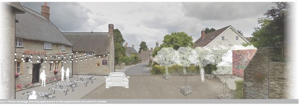
Concept sketch of High Street Improvements
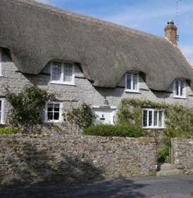
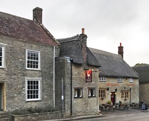
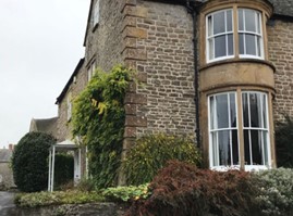
Yetminster, Ryme Intrinseca and Hamlet contain between them some 65 listed buildings a number of which are grade I or Grade II* listed. The predominant building material is limestone, with local Forest Marble and Cornbrash stone being used for rubble walls and roofing tiles and Hamstone for ashlar and dressings. The older buildings have stone mullioned windows with casements, often with leaded glazing. Door surrounds are mainly stone with stone lintels or flat arches. Roofs are a variety of stone tiles, slate and clay tiles.
Modern development has taken place and it is acknowledged that not all of the new buildings are sympathetic in nature or scale to the original villages. This guidance is intended to encourage the reverse of this trend and ensure that future developments reflect and enhance the heritage of the area.
In stating this aim it is recognised that there will be a need to use modern materials and to comply with modern construction methods and legislation, but it is felt that there should be no reason why a satisfactory amalgam should not be achieved.
Y1. Street Layout
The street layouts within the villages generally consist of one or more main thoroughfares with a limited number of side streets.
Streets tend to be linear with gentle meandering to provide interest and evolving views. The minor roads and lanes enhance much of the rural character of the plan’s area. The wide verges and entrance splays that exist in places help give the feel of openness and space which is to be encouraged.
The Neighbourhood Plan does not envisage large scale development and the sites identified are seen as having the potential to encompass and reinforce this existing arrangement.
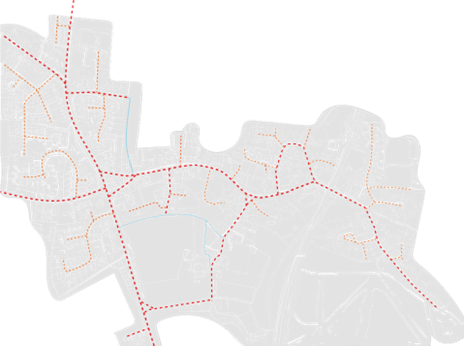
Diagram showing existing street layout in Yetminster. Red dashed lines show the main routes, these are linear in character but with gentle deflections and meandering. Orange dashed lines show cul-de-sacs and tertiary streets with a mixture of linear and meandering layouts.
Where possible, trees should be planted in the street design to help with appearance and biodiversity. This is particularly important where tree planting will soften the boundaries between previous developments and their differing styles.
Consideration should be given to the potential for communal seating and provision for street litter collection, in consultation with the Parish Council.
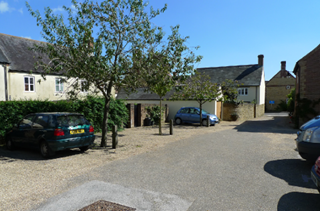
Y2. Open Spaces
The layout of the existing houses and buildings encourages the provision of open space in the form of communal access, open verges, parking spaces and courtyards or similar areas.
New development should continue enabling this “openness” in a positive manner.
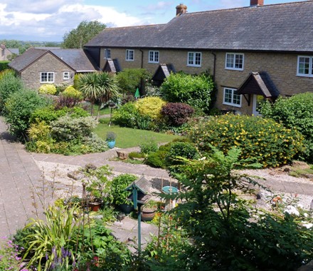
Photo: Bower Court, Yetminster, showing individual gardens forming an open space
Y3. Gateway and Landmark Features
Gateway and built elements highlighting the access or arrival to a particular area, should be included in the designs where practical.
Y4. Pattern and layout of buildings
Existing properties are not regular or uniform in design or style and this should be encouraged with new development.
A variety of styles, for example, a mixture of terraced, semidetached and if applicable detached properties, will reflect the existing housing styles although the actual “mix” will be dependent on the site size.
Properties should have sufficient plot depth to provide suitably sized rear gardens, commensurate with the design and type of building and the needs of the occupants.
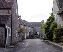
Photo: Queen Street, Yetminster, showing different housing styles
Y5. Building Line and Boundary Treatment
The historic nature of the street layout means that buildings are generally aligned along the main axis with their main façade and entrance facing it. There is a historic irregularity to the boundaries due to the different periods of construction and this should be encouraged in the form of recesses and variations in new development.
Photo: Queen Street, Yetminster, showing an example of a street facing boundary wall.
Boundary treatments will vary but these should be of high quality materials and standards. Boundary treatments facing the street and public areas should reflect the best local examples.
Low walls should be of brick or stone or hedgerows or a combination of these. Hedgerows with some mature tree planting is appropriate on interfaces with the countryside. The use of cheap panel fencing in publicly visible boundaries should be avoided.
Y6. Building Heights and Roofline
Heights of buildings should not exceed three storeys although three storeys, utilising the roof space (rather than an additional built floor), would be considered where felt to be appropriate and where the two story roof line will not be increased.
The roofline should reflect the pitched roof nature of the existing buildings. Unevenness due to lack of general uniformity in building height is encouraged in new development to enhance the established local interest and character.
The encouragement of uneven rooflines and a lack of uniformity should enable glimpses of the surrounding countryside, emphasising the rural nature of the villages
Photo: Yetminster High Street showing varying rooflines
Y7. Corner Buildings
Corner buildings should address the public realm by placing windows on both sides of the corner aspect, using excellent design on both façades of the corner. It would not be appropriate to leave blank façades on one side of a corner building.
Photo: Junction of Queen Street with the High Street, Yetminster, showing corner treatment with windows on both sides
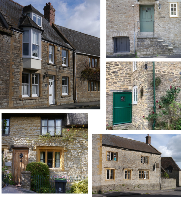
Y8. Architectural Details
Some of the prominent features of the properties found in the three villages and their surrounds are related to the building materials available locally which create a strong local character. This should be replicated through specific architectural types such as cottages or coach houses and by adopting particular architectural details such as focus on creating a detail out of the window element along the facades or a good variety in building line and routine. Uncharacteristic detailing should be resisted.
Design proposals should therefore make reference to local buildings considered of merit, and these photographs show examples of architectural treatments and details to materials that are considered a positive example, and from which influence can be drawn.
Other examples can be found in the Conservation Area Appraisal adopted by the then West Dorset District Council in 2009 (subsequently amended with boundary changes in 2010).
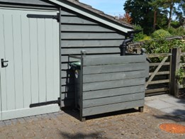
Whilst this document seeks to achieve sympathetic development, it is recognised that modern requirements for waste separation and recycling, the number of household bins and size have increased. This potentially poses a problem in relation to the aesthetics of the property if bins are left without a design solution.Photos: Examples of features which create a strong local character
Waste and cycle storage should, if placed on the property boundary, be integrated with the overall design of the boundary design. Consideration should be given to a range of hard and soft landscaping treatments such as hedges, trees, flower beds, low walls, and the use of high-quality paving materials to minimise the visual impact of bins and recycling containers.
Photo: Example of a sympathetically designed storage facility
Y9. Street Furniture
The overall appearance of the plan area is attractive but the design and siting of street furniture by local authorities and public utilities is often uncoordinated and can detract from the area’s overall attractiveness. Signage should therefore be kept to a minimum to avoid clutter and placed on existing poles or structures where possible.
Overhead cables are visually unattractive and both within the villages, and where there is likely to be an impact on the environment, utility providers should be encouraged to place their services underground wherever possible.
Y10. Vehicle Parking
Residential car parking can be a mix of on-plot, side and front spaces, garage and courtyard parking. Car parking provision must be combined with landscaping to minimise the presence of vehicles and blend with the existing streetscape.
Photo: An example of a landscaped parking spaces
Where provided, garages must reflect the architectural style of the main building, rather than a mismatched unit. Whilst garages can be used as a design element to create a link between buildings, ensuring continuity of the building line, they should not be prominent elements in the street scene. In determining the garage dimensions, consideration should be given to the integration of cycle parking and waste storage within the structure.
On-street parking can be arranged either perpendicular or parallel to the carriageway, but must be designed to allow for the safe flow of pedestrians and cyclists and ensure access for waste refuse and emergency vehicles.
Y11. Sustainability
Eco Design
Energy efficient or eco design combine all around energy efficient construction, appliances, and lighting with commercially available renewable energy systems such as air to heat pumps, solar water heating and solar electricity.
Starting from the design stage consideration must be given to opportunities to incorporate passive solar heating, cooling and energy efficient landscaping, depending on local climate and site conditions.
Solar Roof Panels
It is recognised that solar panels, when installed on a rooftop, can give rise to concern. The design and finish of the panel can be crucial in reducing the panels impact.
On new builds solar panels should be incorporated into the design features from the start. Consideration should be given to the use of solar shingles and photovoltaic slates and the use of solar panels as a material in their own right. Black solar panels with black mounting systems and frames can be an appealing alternative to blue panels.
On retro fits the proportions of the building and roof surface will dictate and potentially limit what will be the best location and size of panel to be used. Wiring and ancillary equipment should be concealed so as to limit their impact.
Consideration should be given to introducing other tile or slate colours in order to create a complimentary composition with the solar panel materials being considered. Contrast and boldness should not be rejected providing it is used in proportion.
Rainwater Harvesting
Simple and straightforward measures will allow for the capture and storage of rainwater as well as the use of grey water. The pipework and storage devices used in storage systems can be unsightly and consideration should be given to concealing tanks using complementary materials and attractive materials. New developments should utilise pervious ground cover for parking areas and underground tanks from which the collected surface water can be re-used.Policy EN1: Building Conservation
Policy EN2: Local Landscape Character
Policy EN3: Local Biodiversity
Policy EN4: Local Green Spaces
Policy EN5: Land of Local Landscape Importance
Policy EN7: Important Open Gap
Policy EN8: Footpaths and Bridleways
Policy CC1: Minimising Carbon Footprint
Policy CC2: Individual and Community Scale Energy
Policy CC3: Renewable Energy and Waste Reduction in Building Design
Policy CC4: Energy Generation to Offset Predicted Carbon Emissions
Policy CS1: Existing Community and Leisure Services and Facilities
Policy CS2: New Community and Leisure Services and Facilities
Policy H4: land fronting Melbury Road, Yetminster
Policy H5: the site of ‘Kilbernie, Chapel Lane, Yetminster
Policy H7: land at Downfield, Ryme Intrinseca
Policy H8: land at the Old Forge, Ryme Intrinseca
Policy BS1: Sustainable Growth of Businesses
Policy T3: Electric Vehicle Charging Points
Project P1: National Park Status
Project P2: Maintenance of Public Footpaths and Bridleways
Project P3: Lime Kiln Restoration
Project P4: Improving Community and Leisure Facilities
Project P5: Assets of Community Value
Project P6: Community Engagement
Project P8: Working in Partnership to Improve Road Safety
Project P9: High Street Improvements
Project P10: Flood Alleviation
Policies H3 and H6 were not carried forward from the draft plan and therefore do not feature in the list of policies.