
4.1 The Neighbourhood Plan aims to preserve and enhance the rural and built environment. The early consultations highlighted the fact that residents have a strong attachment to Yetminster and Ryme. They value the historic environment and the rural setting, recognising that although Yetminster and Ryme are closely connected, they are separate and each has its own distinctive character.
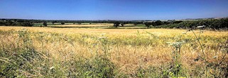
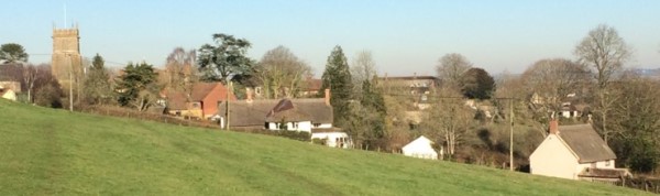
4.2 The villages of Yetminster and Ryme Intrinseca sit on the Thornford Ridge. This provides open views over the valleys, particularly to the north, from the lanes and rights of way that criss-cross the area. The retention of these views and rights of way is of great importance to the community.
The view from the Thornford Ridge
4.3 The Neighbourhood Plan area abuts the Dorset Area of Outstanding Natural Beauty (AONB) and the quality of the local landscape is such that a case could be made for extending the AONB boundary to the east and also for including the area in the proposed Dorset & East Devon National Park. 11
4.4 The Neighbourhood Plan is also concerned with the built environment and with the impact of new development on the character and appearance of the area. Account has been taken of government guidance12 in the design policy (H9) which is within the housing section of the plan because this is where development is most likely to occur. It should be noted, however, that this policy and guidance are applicable to all forms of development.
4.5 Yetminster Conservation Area (map 2) covers the relatively unspoilt core of the village which is described as having a ‘remarkable concentration of post medieval gentry and farmhouses.13 The area’s special interest, as described in the Conservation Area appraisal, is summarized in Table 1.
Table 1: Yetminster Conservation Area – Special Interest
Detrimental features noted include:
|
4.6 The National Heritage List for England (NHLE) provides the official register of all nationally protected historic buildings and sites in England, including listed buildings and scheduled monuments.14 The most significant buildings listed for their architectural or historic interest in Yetminster are:
4.7 Ryme Intrinseca does not have a Conservation Area but eight listed buildings are included in the NHLE. The most significant are:
4.8 The smaller settlement of Hamlet includes the Grade 2* Hamlet House, with its Attached Maltings and Outbuildings. The barns, stables and coach house are also separately Listed, making a significant grouping here.
4.9 The following Locally Important Buildings and Features were identified in the Conservation Area Appraisal and in liaison with Dorset Council’s Conservation Team, and whilst not formally designated would still be classed as heritage assets. There are also several lime kilns in the area noted on the Historic Environment Record, some of which are clearly evident such as the one on Downs Lane.
Table 2: Locally Important (unlisted) Buildings and Heritage Features
|
Environment Objective 1 To safeguard the historic environment including the integrity of the Conservation Area, nationally protected buildings and sites and buildings of local historic value. |
Policy EN1: Building Conservation New development (including alterations and extensions) should make a positive contribution to the conservation of heritage assets in the Neighbourhood Plan area, and pay particular regard to: (a) protecting the setting of Listed buildings and buildings of Local Historic Interest (as identified in Table 2 and described in detail in the Yetminster Conservation Area Appraisal, and including the Old Forge in Ryme Intrinseca), and (b) preserving or enhancing the character or appearance of the Yetminster Conservation Area, including the features of special interest and opportunities to address detrimental features (as identified in Table 1 and described in detail in the Conservation Area Appraisal). |
4.10 The area lies on the edge of two national landscape character areas (Yeovil Scarplands to the north and the Blackmore Vale covering the main settlements and land to the south). Fields are defined by hedgerow boundaries with incidental hedgerow trees (mainly oak). Some fields have distinctive curving and dogleg field boundaries formed during the enclosures of the late-medieval or post-medieval period and tend to be smaller around the fringes of the settlements. There are woodlands of varying size and type. Key concerns identified through the local landscape character appraisals15 include fragmentation of hedgerows and/or loss and decline in hedgerow trees, loss of wet woodland and riverside vegetation and the negative visual impact of some of the large agricultural buildings. These features are referenced in policy EN2.
4.11 Five sites of County or local importance for nature conservation within the Neighbourhood Plan area are protected by Local Plan Policy ENV2. These include areas of deciduous woodland, unimproved and semi-improved grassland. The churchyards and railway embankments are of local wildlife interest. In addition, the hedgerows, coppices, open fields, rivers and streams throughout the area support a rich variety of flora and fauna.
Vecklands (Millennium Wood)
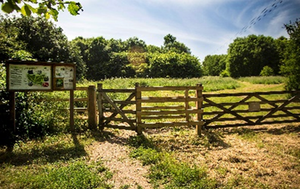
4.12 Areas of existing and potential ecological value, as identified through work undertaken on behalf of the Local Nature Partnership, are shown on map 7. Policy EN2 highlights the importance of protecting and enhancing these natural resources and is important to the wellbeing of the area.
4.13 The plan area also lies within the hydrological catchment of the Somerset Levels and Moors Ramsar site. This has implications for waste water (and its treatment) to ensure that development does not indirectly impact on this internationally important wildlife site.
4.14 Several sites have been identified as having particular importance as Local Green Spaces (LGS) (including sites for sport and physical activity) in line with national planning policy16 (map 4).
4.15 Policies for managing development within a Local Green Space should be consistent with those for Green Belts. Accordingly, certain forms of development might be acceptable as illustrated in NPPF paragraphs 149 and 150. However, whilst the NPPF states that “limited infilling in villages” may not be inappropriate development in the Green Belt, given that Yetminster and Ryme Intrinseca are both villages, limited infilling here would be contrary to the aims for the designated LGS, and Policy EN4.
4.16 In addition, the medieval fields to the north of Yetminster village and the fields and gardens between houses on Church Street in Yetminster and the River Wriggle, which are recognised as Land of Local Landscape Importance (LLLI). These were originally defined in the 2006 Local Plan, and retained by the 2015 Local Plan pending further work to develop a coherent green infrastructure network. Having reviewed their scope through this Neighbourhood Plan, these locally valued landscapes should continue to be safeguarded (but they do not readily meet the Local Green Space criteria due to their size).
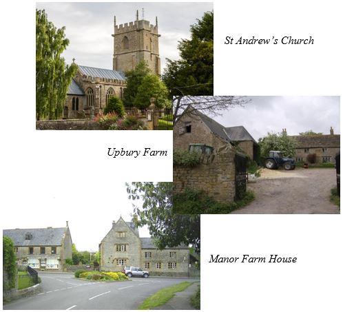
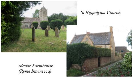
Table 3: Reasons for Designating Local Green Spaces and Land of Local Landscape Importance LGS 1: Land at St Andrew’s Church and Upbury Farm, Yetminster. This enhances the setting of St Andrew’s Church and Upbury farmhouse and the adjoining buildings. The land also provides an important green wedge in the centre of the village. It was recognised as Land of Local Landscape Importance in the 2015 Local Plan, but is considered to meet the criteria for LGS designation. LGS 2: Land at the entrance to Cross Farm, Yetminster. The grassed and treed bank by Priors Cleve (which frames long views along the street) and space allowing sudden fine views to the church tower, is recognised as a significant and important undeveloped gap in the Conservation Area Appraisal. The development of land behind Croft Cottage was allowed following an appeal on the basis that this open space was not harmed, during which there was considerable local concern about the impact on this open space. LGS 3: The sports field and allotments in Yetminster. This area provides important recreational space used by the community. LGS4: The Meadens Open Space, Yetminster. This provides the only recreational space within the Cloverhay / Clovermead / Bucklers Mead residential area at the western end of the village. LGS 5: Vecklands (Millennium Wood). Yetminster. This is valued for informal recreation and for its wildlife. LGS 6: Green triangle between the railway and Eastlands. A visually prominent green space adjoining the River Wriggle, bringing the countryside into the heart of the village. LGS 7: the grounds of St. Hippolytus Church in Ryme Intrinseca. This enhances the setting of St. Hippolytus Church and provides a pleasant place for quiet contemplation and remembrance. LLLI 1: The medieval fields to the north of Yetminster village. These fields contribute to the character of the settlement and reinforce the historic relationship between the built and natural environment. These appear to be prebendal crofts which have remained largely unchanged since at least 1840 and were recognised in the extension of the Conservation Area. LLLI 2: The fields and gardens between houses on Church Street in Yetminster and the River Wriggle. These act as a green buffer between the village and the railway providing an attractive setting for the river, and provide an important wildlife corridor running north-south along the railway. The Conservation Area was extended to include the area closest to Church Street in recognition of historic land tenure in this particular area that similar has remained largely unchanged since at least 1840 |
4.17 In addition to the above LGS and LLLI designations, the gap between Yetminster and Ryme Intrinseca, which stretches on both sides of the road, is about 500m in length. It is important to retain the open nature and breadth of this gap in order to maintain the individuality of the two villages. Although there are occasional buildings within the gap, any intensification of buildings and even limited infill development would diminish the generally rural nature of this stretch of countryside. All of these areas are protected through policies EN4, EN5 and EN7.
4.18 The following views, shown on map 5 and safeguarded in policy EN6, are regarded as important by the community:
1. St Andrew’s Church from Vecklands (Millennium Wood) – the view to the west enhances what is a well-used recreational space.
2. St Andrew’s Church from High Street.
3. St Andrew’s Church along Church Street.
4.19 There are many public footpaths and bridleways in the Plan area, most of which radiate from Yetminster. These include part of the MacMillan Way long distance footpath. Many of these routes are maintained in good condition, but others are not.
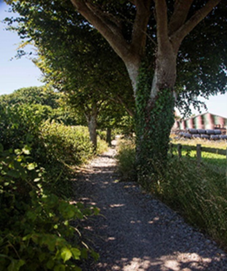
4.20 In addition, there are two permissive footpaths: one known as Scrap’s Way along part of the roadside between Yetminster and Ryme Intrinseca; the other from High Street to Stonyacres.
Scrap’s Way
4.21 Further new and improved footpaths may be provided in association with housing development.17 There may also be further opportunities to improve links between settlements and create circular recreational paths, which should be encouraged. One such opportunity is for a link around the northern edge of the village and connecting to the existing paths from the High Street and Station, the western connection from Thornford Road being created through the development of land at Folly Farm. Another would be the link from Queen Street to Melbury Road / Birch Lane across the field west of Upbury Farm.
Environment Objective 2 To protect and maintain green spaces, wildlife areas, footpaths and views within the plan area. |
Policy EN2: Local Landscape Character Development should be designed and located to respect the area’s distinctive landscape character, in particular:
Opportunities should be taken to soften the hard urban edges of the settlements, particularly as visible from public rights of way, and to screen or reduce the adverse visual impact of existing detrimental features such as large agricultural buildings |
Policy EN3: Local Biodiversity Development proposals should be supported by proportionate evidence that demonstrates how they will protect and, wherever practicable, enhance local biodiversity, through an understanding of the wildlife interest that may be affected by development, and the inclusion of measures that will secure an overall biodiversity gain. 18 |
Policy EN4: Local Green Spaces The Local Green Spaces shown on map 4 and listed as LGS in Table 3 will be given special protection. Development must not harm the reason for their designation. Policies for managing development within them should be consistent with those for the Green Belt and inappropriate development should not be approved except in very special circumstances. |
Policy EN5: Land of Local Landscape Importance The areas shown as Land of Local Landscape Importance on map 4 and listed in Table 3 were designated as such in 1998 and their importance has not diminished. Development which would cause harm to their landscape character or undermine the reasons for the area’s designation will not be permitted. |
Policy EN6: Views The important views identified on map 5 and described in paragraph 4.18 are to be respected. Development within the Neighbourhood Plan area that that would significantly intrude and impact on their enjoyment by virtue of scale, massing, design or location will not be supported. |
Policy EN7: Important Open Gap The open gap between Yetminster and Ryme Intrinseca as shown on map 4 (areas 9 and 10) will be maintained. Development proposals which include new buildings, structures and land uses that would undermine the rural, undeveloped nature of this gap between these settlements will not be permitted. |
Policy EN8: Footpaths and Bridleways Proposals to improve public access along public footpaths and bridleways in the area, including the use of permissive paths and opportunities to create new footpaths and bridleways and better links, will be supported. |
12 National Design Guide, Ministry of Housing, Communities and local Government, September 2019
13 Yetminster Conservation Area Appraisal 2010, page 21. See also The Houses of Yetminster: R Machin, University of Bristol Department of Extra-mural Studies (1978)
15 as defined in the West Dorset Landscape Character Assessment, February 2009
16 This designation is defined in the National Planning Policy Framework, paragraphs 101-103. The reasons for the sites' designation are provided in Table 3 and further considered in the Basic Conditions Statement in the supporting evidence.
17 See paragraph 7.23 and Policy H4
18 For detailed requirements see Dorset Biodiversity Appraisal Protocol, version 3, Autumn 2018 (or later versions as may be published)
< Previous | ^ Top | Next >