
7.1 A Housing Needs Assessment was undertaken by the Steering Group in October 2017 with four aims: (i) to establish how much new housing is required in the plan area in the period to 2036; (ii) to consider where new housing should be located; (iii) to identify what type of housing is required; and (iv) to consider what form it should take. This has since been updated in light of the emerging housing needs evidence supporting the Dorset Local Plan.
7.2 The Neighbourhood Plan area does not constitute a housing market area on its own and neither the adopted Local Plan nor the previous West Dorset, Weymouth and Portland Joint Local Plan Review identifies specific housing need at a village level. The Neighbourhood Plan is therefore considered data from a range of sources, in consultation with Dorset Council, to determine a notional housing needs figure for the area. 20
7.3 The adopted Local Plan identified a need for 15,500 new homes across the plan area for the 20-year period from 2011-2031, with the majority of development concentrated in and around the main towns. Policy SUS2 states that development in settlements like Yetminster, with a Defined Development Boundary (map 3), should be ‘at an appropriate scale for the size of the settlement’ but this is not defined in numerical terms.
7.4 The Joint Local Plan Review sought to ensure that the local economy is not constrained by a lack of suitable housing. The Review therefore proposed provision of a deliverable supply of housing land to accommodate 775 dwellings per year – a total of 15,500 new homes over the revised plan period 2017-2036. The strategy continued to direct the majority of housing to the towns with no requirement for rural settlements like Yetminster to contribute to meeting ‘strategic’ development needs.21
7.5 Against this background, a pro-rata assessment of the 775 dwellings per year was used to establish a starting point for considering the likely housing needs for the Neighbourhood Plan area. This suggested that a total of 144 dwellings would be required for the 25-year period 2011-2036 (covering the adopted plan and its roll-forward through the review).
7.6 The first draft of the Local Plan was produced in January 2021 and proposed that the indicative housing target for Neighbourhood Plans areas such as Yetminster and Ryme Intrinseca should be based on the existing commitments (76 dwellings as of 1 April 2020) plus a windfall allowance based on past trends, which for our area would be 1.6 dwellings per annum (for the period 2024 – 2038). This would therefore equate to a ‘pro-rata’ housing requirement of at least 115 dwellings for our plan period (taking into account completions since 2017 and the shorter time period).
Table 5: Housing Needs Target (2017-2036) Completions 2017 – 2020 20 dwellings
|
7.7 The ‘windfall allowance’ is expected to comprise further infill within the existing Defined Development Boundary together with rural workers’ housing, rural exception affordable housing and the conversion of existing buildings. In the year from April 2020 – 2021 a further 10 dwellings were allowed (some of which were only allowed as an exception to normal policy because of the lack of a 5 year housing land supply):
Table 6: Windfall (2020-21): 11 dwellings
|
7.8 Having reviewed all of the information available, the target of at least 115 dwellings proposed through the emerging Local Plan is considered to be a reasonable target for the Neighbourhood Plan. This equates to about 6 dwellings a year, which is higher than recent build rates but about the same as the rate of development in the latter part of the 20th century. This number of new homes would also be more than sufficient to meet identified local affordable housing needs. 22
7.9 A ‘call for sites’ was made at the end of 2017 as a result of which twelve proposals were submitted. Two more sites were considered because they had been submitted as part of the Strategic Housing Land Availability Assessment (SHLAA) undertaken by the District Council. A further two potential sites were identified by the steering group and have been assessed even though they were not submitted by the landowner. Each of the sites was assessed in two ways . 23
7.10 First, against general criteria and planning constraints including:
7.11 Second, the sites were assessed against two factors identified at a series of informal public discussions in September 2016 and via a questionnaire a year later:
7.12 The choice of sites has been made in the light of the overall Neighbourhood Plan objectives, the implicit and explicit housing criteria in this section of the plan, and the nature and size of suitable sites. They were also tested as part of the sustainability appraisal process. Sufficient site allocations have been made that slightly exceed the notional housing target in order to provide some flexibility in their delivery.
7.13 With regard to the issue of increased phosphate levels entering Somerset Levels and Moors Ramsar Site, in order to avoid harm to this internationally important wildlife site it will be important that any development achieves phosphate nutrient neutrality. This can be done by including measures to ensure that the overall amount of phosphorous arising from the development is off-set by reductions elsewhere, for example through removing land from intensive agricultural production to a less intensive use with a lower phosphate level. There are a number of ways in which this can be achieved, and further guidance is being developed by the local planning authorities in conjunction with Natural England.
7.14 A Defined Development Boundary (DDB) for Yetminster in the adopted Local Plan was designed to ensure a robust approach to speculative planning applications and to safeguard the rural character of the surrounding area. The planning permission for land at Thornford Road25 breached the DDB and modifications to the DDB are made in this Neighbourhood Plan to take account of this and of additional housing site allocations. Any proposals for additional housing within this boundary should respect the character and appearance of the area, much of which is within or adjoining the Conservation Area where development should be of a high standard of design which preserves or enhances the particular qualities of the area.
7.15 A majority of those who attended the public discussions agreed that limited additional housing of an appropriate kind would add diversity to the housing stock and help to bring further life and vitality to the community. For example, there is a comparatively high proportion (28%) of larger (4 and 5 bedroom) detached houses, particularly bearing in mind that less than 1 in 6 households have more than 3 occupants. This means that there are comparatively fewer smaller (and therefore generally less expensive) dwellings. New housing development should therefore not just be thought of in terms of numbers, but should make a positive contribution to the area as part of a long term vision for the community and to assist in meeting the changing needs of existing residents.
7.16 The available data, public discussions and questionnaire referred to above identified three particular types of housing for which the plan should aim to make provision:
7.17 Whilst the 2011 Strategic Housing Market Assessment for the Dorchester / Weymouth Housing Market Area suggested that less than 20% of new open market housing should be for 4+ bedroom dwellings, and it is clear that there is little local need for such larger homes. On this basis, a limit of 20% of the total dwellings is considered reasonable when considered on a site by site basis, in order than the focus of provision is on smaller homes in line with the above findings. It is clear that without such a restriction housebuilders will opt for a higher proportion of larger homes (as was the case on the Thornford Road site).
7.18 The public discussions and questionnaire identified a wish to ensure that those with a local connection who register a wish to remain in, or return to, the area should be given priority when affordable housing becomes available. This is appropriate within the Neighbourhood Plan area, as the Local Plan’s strategy is about meeting local (rather than strategic) housing needs in this area. A local connection is defined in Dorset Council’s Housing Allocations Policy and some of the key criteria include:
7.19 For the purpose of this plan, the area is the Neighbourhood Plan area and the adjoining civil parishes of Chetnole, Leigh, Beer Hackett and Stockwood, Melbury Osmond and Lillington.
Housing Objective 1 To provide sufficient housing to meet the anticipated local housing needs within the plan period. |
Policy H1: Housing Land The Defined Development Boundary is updated (as shown on map 3) and sufficient land has been allocated that, together with the site for 85 dwellings at Thornford Road, other extant consents and infill sites that may arise within the DDB, should more than meet the anticipated local housing need within the plan period. The site allocations are:
Housing development, including the above site allocations, will only be supported if it can achieve phosphate neutrality regarding Somerset Levels and Moors Ramsar Site. On this basis the release of sites for housing development outside the Defined Development Boundary should be limited to rural workers’ housing, rural exception affordable housing and the conversion of existing buildings.27 |
Policy H2: Housing Types Taking into account the current range of house types and sizes and likely demand in view of the changing demographics, residential developments should include a mix in the size, type and affordability of dwellings proposed with an emphasis on:
On sites of 3 or more dwellings larger homes (with the equivalent space for four or more bedrooms) should not exceed 20% of the total dwellings (or more than 1 unit on sites of 3 or 4 dwellings). Where affordable housing is required, legal agreements will be sought with the developers and providers of affordable housing to ensure that it is prioritised to people with a local connection, giving preference to those with a local connection to the Yetminster and Ryme Intrinseca Neighbourhood Plan Area, followed by those with a local connection to the neighbouring parishes, followed by those with a local connection to the remainder of the Dorset Council area, and in accordance with the Dorset Housing Allocations Policy, and remains so in perpetuity. |
7.20 Sites with a potential capacity which altogether could provide well in excess of 200 dwellings (in addition to the 85 already approved in detail) were submitted as a result of the call for sites, the local authority’s latest SHLAA and the work of the steering group. All these sites were analysed against pre-determined criteria and several were ruled out because they are well outside the villages or because planning permission has been refused previously or dismissed on appeal. The sites described below and identified on map 3 are considered to be the most suitable to meet the needs of the local community and to satisfy the housing objectives of this plan. These have therefore been allocated for development within the Plan Period.
Housing Objective 2 To identify sites for new housing. |
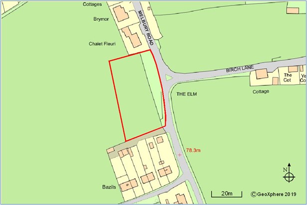
7.21 On the west side of Melbury Road there is a continuous frontage of housing development except for a gap between ‘Chalet Fleuri’ and a group of houses known as ‘Bazils’. The land in this gap is not subject to any environmental protection policies nor is it within the Conservation Area. In view of this and the existing pattern of development on this side of Melbury Road, infill development would not cause significant harm to the character and appearance of the area. Nevertheless, consideration would still be needed to ensure the scale, design and layout of the development relates positively to the junction with (and view from along) Birch Lane and does not dominate the skyline.
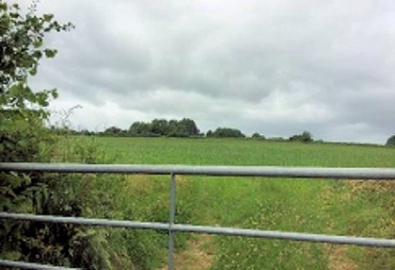
7.22 The site is in two separate ownerships: a narrow frontage strip and part of the field behind. The eastern part of the site contains the remains of a row of stone cottages likely to date to 1840 or earlier, recorded as The Elm and Green / Elm Green, and this area should not be developed. But it would be appropriate for any housing on the land to the rear to commemorate the name of Elm Green to better reveal the site’s historic significance.
7.23 Development of this site is likely to require cooperation between the two owners to ensure satisfactory vehicular access, although other options may be explored. This should not interfere with farming access to the remainder of field. The Highways Authority has raised concerns about the poor vertical alignment and width of the highway in this location, and lack of safe pedestrian access from the site into the village to access the community facilities and services. The landowner who owns the majority of this site also owns the field Upbury Farmhouse and the adjoining fields, therefore one possible solution would be the provision of an off-road, all-weather footpath across the land to the rear of Upbury Farmhouse, linking from opposite the site entrance to Queen Street. It is also hoped that any funds from the sale of this land for housing may facilitate the repair and restoration of Upbury Farmhouse (which is a Grade 2* listed building in urgent need of repair and restoration) as soon as possible.
Policy H4: land fronting Melbury Road, Yetminster The site shown above and on map 3 is allocated for up to six dwellings, subject to all of the following requirements:
|
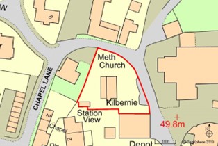
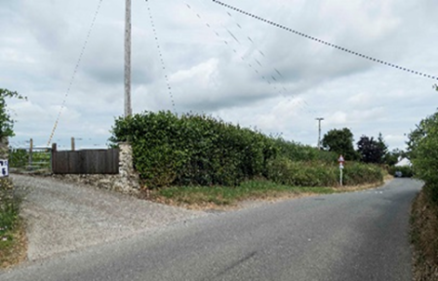
7.24 Kilbernie’ is an existing bungalow on a prominent site on the inside of a bend near the junction of Station Road and Chapel Lane.
7.25 On the opposite side of the road to the east is a car sales site but to the north is Lower Farm House and the adjoining barns which are Grade 2 listed buildings. Behind the site to the west is the attractive Methodist Chapel, which is of local historic importance. The western part of the site is within the Conservation Area and the existing bungalow detracts from the character and appearance of the area and from views into the area from the east. Two or three modest dwellings (such as a pair of cottages or small terrace) could be readily accommodated on the site, in place of the existing dwelling. Given its context, any buildings should be of a high quality, with sympathetic design and materials and not compete visually with the adjoining Farm House or Chapel.
7.26 There are several existing vehicular access points opposite the site and access for the proposed development should therefore be as close as possible to the existing bungalow access to minimise conflicting traffic movements. It may also be appropriate to seek financial contributions towards improving shared-surface pedestrian connection to High Street along Chapel Lane (along with the site identified in Policy H6).
Policy H5: the site of ‘Kilbernie, Chapel Lane, Yetminster The site shown above and on map 3 is allocated for up to three dwellings subject to all of the following requirements:
|
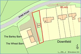
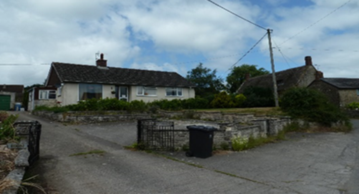
7.27 Approval was granted in July 2014 for the change of use of an agricultural building to two dwellings. The resulting substantial buildings together with associated outdoor space occupy most of the site but there is scope for one further dwelling which would have the effect of ‘rounding off’ this outlying part of Ryme Intrinseca and allow for further landscaping to be included to soften the visual impact of the proposed and existing development including views from Downs Lane (an unclassified Green Lane heading west from Church Farm) to the south. The area closest to the mature trees (including native oak) along the road boundary should be avoided as these are worthy of retention.
7.28 It is accepted that development in this location will be more reliant on the private motor car for the majority of its trips, given the distance to facilities.
Policy H7: land at Downfield, Ryme Intrinseca The site shown above and on map 3 (inset) is allocated for one dwelling subject to all of the following requirements:
|
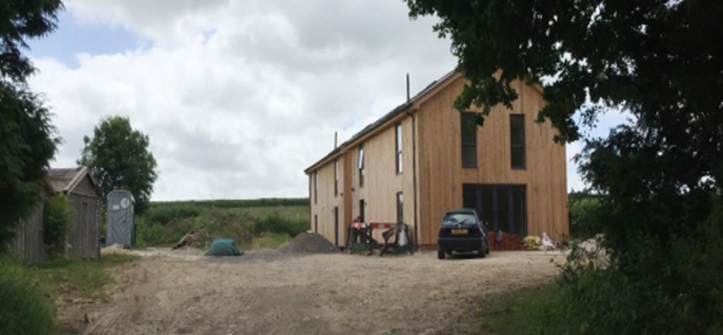
7.29 The original forge is a stone building of some age, being at least 180 years old and possibly older. The Conservation Team at the Local Planning Authority have indicated that the old Forge building is of local historic importance and therefore should be considered as a non-designated asset, and its demolition would not be supported. The building has been ill-maintained in recent years and is currently used for commercial purposes. The concrete lean-to is a modern addition but has enabled the building to continue to be used as a forge, but the removal of these modern additions would better reveal its historic significance.
7.30 Whilst the building could be retained in a commercial / industrial use, this may not be viable in the long term. Subject to a structural survey the building could probably be converted into a small dwelling retaining, as far as possible, the traditional character of the front of the building. The lean-to structure attached to the western elevation of the Old Forge could be removed in order to improve the existing access for vehicles with better visibility. Although the potential loss of its existing commercial uses (as small workshop accommodation) is regrettable, it is important that the historic building is used in a way that enables it to be maintained in a good state of repair.
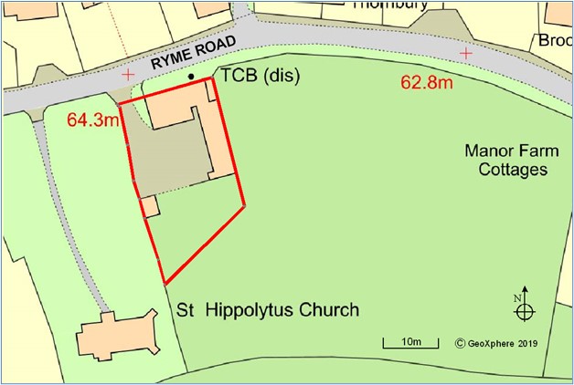
7.31 The site adjoins St Hyppolytus Church which is a Grade2* listed building and the relationship between the new housing and the church building and churchyard is of particular importance. Development to the south of the forge building is likely to affect the setting of the Grade II* church, but this could be mitigated by restricting development to no further than 40m from the street on the eastern boundary of the plot and 50m on the western boundary.
7.32 It may be possible to accommodate up to 4 dwellings (including the conversion of the Old Forge). These should be modest in size, having regard to the nearby historic buildings and landform, providing additional choice within the village, which mainly has larger, detached house types.
7.33 The land behind the Old Forge rises from the road towards the back of the site and any reduction in run-off rates may help reduce the flooding problems experienced further along the road (to the east), and should therefore be encouraged as a potential benefit.
7.34 It is accepted that development in this location will be more reliant on the private motor car for the majority of its trips, given the distance to facilities.
Policy H8: land at the Old Forge, Ryme Intrinseca The site shown on above and on map 3 (inset) is allocated for housing (through the re-use of the Old Forge building and land to the rear) for up to 4 dwellings) subject to all of the following requirements:
|
7.35 Good quality design is an integral part of sustainable development. The National Planning Policy Framework recognises that design quality matters and that planning should drive up standards across all forms of development.28 Achieving good design is about creating places, buildings, and public spaces that work well for everyone, look good, last well, and will adapt to the changing needs of present and future generations. This should therefore be at the heart of the planning process and permission should be refused for poorly designed development.
7.36 National planning policy also promotes the efficient use of land, avoiding unnecessarily low-density developments. Plans can set densities to reflect local circumstances, and it is sometimes appropriate to set out a range of densities that reflect the accessibility and potential of different areas. Careful and skilful design will be needed to ensure that new housing development does not detract from the character and appearance of the locality and that local considerations are given full weight alongside theoretical standards.
7.37 Without sufficient care and architectural skill, the application of higher densities to conventional housing can result in cramped living spaces with poor internal layout. The Neighbourhood Plan therefore seeks to achieve high standards for internal spaces as well as the external environment.
7.38 The Neighbourhood Plan also seeks to ensure that new housing respects the historic built environment and rural setting of the two main villages; follows the principles of good design, layout and landscaping; uses harmonious materials; and creates a pleasing public realm. However, this does not rule out outstanding or innovative modern designs using new construction materials and techniques which help to raise the standard of design in the area and achieve high levels of sustainability.
7.39 Good design extends beyond the external appearance of individual buildings to their relationship with one another and to their setting. So, for example, affordable housing should not be distinguishable from private housing by its design, nor should it be banished to the least attractive part of the site. Overall, new housing should create a pleasing public realm with attractive and inviting vistas framed by well-considered landscaping.
7.40 Good quality design also involves thoughtful attention to such practical things as arrangements for storing refuse bins, access to meter boxes, space for drying clothes and places for deliveries. Vehicle parking has a major impact on the character and appearance of housing areas and should be considered as an integral part of the overall design. Within individual dwellings the layout and relationship of spaces, storage, daylight and sunlight all contribute to the pleasure and wellbeing of the occupants.
7.41 We have included some design guidance that is specific to our area in Appendix D.
7.42 To assist in achieving the best possible outcome from housing development (including alterations and extensions to existing houses), landowners and developers should engage in discussion with the Local Planning Authority and the Parish Council at the earliest possible opportunity on the basis of the guidance in Policy H9.
Housing Objective 3 To achieve well designed housing. |
Policy H9: Design New development should deliver sustainable high-quality design. To be supported, development proposals must:
Design guidance specific to the Neighbourhood Plan area (contained in Appendix D) should be followed. Regard should also be had to the National Design Guide and the National Model Design Code. |
20 Full details of the data underpinning the housing need conclusions are provided in the separate Housing Needs Assessment report
21 NPPF (2021) paragraphs 66-67
22 See Appendix B for definition of affordable housing.
23 For more details of the site selection and assessment process please see the supporting evidence
24 NPPF (2021) paragraph 79 notes that "... development in one village may support services in a village nearby." Policies H7 and H8 are based on the close relationship between Ryme Intrinseca and services in Yetminster.
25 See paragraphs 7.14-7.17
26 Whilst the term "down-sizing" is often associated with such needs, the ground floor footprint of the homes is not necessarily smaller given the need for the accommodation to be accessible and adaptable.
27 NPPF (2021) paragraphs 11-14 and 78-80
28 See also the National Design Guide, September 2019
< Previous | ^ Top | Next >