
9.1 The population of the neighbourhood area in April 2021 was approximately 53,400 comprising 24,600 households.58 Average household size was 2.2 persons. A third of households in 2021 were single person households and 14% were four or more persons.
9.2 In 2021 a quarter of households lived in a flat, maisonette or apartment. 14% of all households occupied a one-bedroom dwelling, 29% a two-bed dwelling, 39% had 3 bedrooms, and 18% had four or more bedrooms. Almost two-thirds of households owned their home. A third were in rented accommodation (14% social rented, 20% private rented). All evidence suggests that area in and around Weymouth Town Centre has the highest proportion of flats and many bedsits.
9.3 Properties in Weymouth had an overall average price of £311,928 in 202259. Most sales in Weymouth during the year were detached properties, selling for an average price of £474,572. Terraced properties sold for an average of £263,630, with flats fetching £185,784. Overall, sold prices in Weymouth over the last year were 10% up on the previous year and 16% up on the 2020 peak of £268,533.
9.4 A Housing Needs Assessment60 (HNA) was commissioned by the Steering Group in 2021. It concluded that average house sale prices were unaffordable to those on average incomes (with an average resale home requiring an income of over £60,000 and a new build requiring on average an income of over £100,000). Households on two lower quartile incomes cannot afford any of the available tenures in Weymouth without recourse to benefits to top up their incomes, except social and affordable rent. The only affordable ways to home ownership for those on an average income in Weymouth are either through shared ownership at 25% or through a discount market sale scheme, which would have to offer a minimum discount of at least 34%.
9.5 The HNA has been updated to reflect the latest data from Census 2021 and the 2021 LHNA61 produced by Dorset Council. The 2024 HNA report62 reaches similar conclusions. Local households on average incomes are unable to access even entry-level homes unless they have the advantage of a very large deposit. Private renting is generally only affordable to higher earners. Households on mean incomes can only afford entry-level rental affordability thresholds. Households on below average and lower quartile earnings have limited choice within the market.
Affordable rented housing is generally affordable to households with two lower earners, with households with a single lower earner only able to afford social rented housing.
The HNA 2024 recommends that in Weymouth First Homes are delivered at a 30% discount, making the product affordable to households on mean incomes and with two lower quartile earners. Shared ownership appears to be slightly more affordable than First Homes but is broadly accessible to the same groups, with the exception of shared ownership at 10% equity, which is accessible to households with one lower quartile earner. Rent to Buy may offer a useful product to meet the needs of some households with little or no savings for a deposit.
9.6 In August 2024 Dorset Council informed the Steering Group that there were 1,166 applications to the Housing Register for homes in Weymouth this is an increase of 207 since September 2023. Of these applications, 513 have a local connection and 653 do not. The figure for numbers in Temporary Accommodation has increased in the same period from 158 to 163. This includes 50 households with 99 children. There is movement on the figures with only 1 household having been in Temporary Accommodation for more than 6 weeks. As can be seen in the table below these are categorised in bands A-D according to urgency of need. The average waiting time on the housing register across Weymouth and Portland ranges from 289 days Band A to 678 in Band D with an average across the bands of 366 days. Since 2021 471 households have been found homes via the Housing Register process.
| Households with a local connection to Weymouth | ||||||
|---|---|---|---|---|---|---|
| Row Labels | 1 | 2 | 3 | 4 | 5 | Total |
| Band A - Urgent Housing Need | 20 | 9 | 4 | 2 | 1 | 36 |
| Band B - High Housing Need | 65 | 19 | 13 | 3 | 1 | 101 |
| Band C – Medium Housing Need | 64 | 33 | 36 | 3 | - | 136 |
| Band D – Low Housing Need | 178 | 48 | 10 | 3 | 1 | 240 |
| Grand Total | 327 | 109 | 63 | 11 | 3 | 513 |
| Households requesting to live in Weymouth | ||||||
|---|---|---|---|---|---|---|
| Row Labels | 1 | 2 | 3 | 4 | 5 | Total |
| Band A - Urgent Housing Need | 25 | 7 | 6 | 3 | 1 | 42 |
| Band B - High Housing Need | 83 | 16 | 8 | 2 | 2 | 111 |
| Band C – Medium Housing Need | 75 | 32 | 23 | 11 | 1 | 142 |
| Band D – Low Housing Need | 258 | 74 | 19 | 7 | - | 358 |
| Grand Total | 441 | 129 | 56 | 23 | 4 | 653 |
9.7 Dwellings that are affordable to local households are much needed. The HNA 2024 reports a chronic need for affordable homes in Weymouth. It estimates that up to 134 new affordable homes for rent per annum plus 108 new affordable homes to buy per annum are needed, together totalling 242 new affordable homes per annum.
9.8 The most recent strategic housing requirement for Weymouth for the period 2021 to 2038, set by the LPA, is 3,118 dwellings over the remaining 15-year period. This figure was updated from 3,225 to take account of 314 homes built between April 2021 and March 2023, reducing the number of homes with extant planning permission to 1,396, and adjusting the Large Windfall site estimate by 140 and the Small Windfall site estimate by 217. The site allocations without planning permission are based on 400 homes in the Town Centre (WEY2) and 150 homes in WEY14 Land South of Wey Valley, as recorded in the Dorset Local Plan Draft of 2021.
| Source of Supply | Number of Dwellings |
|---|---|
| Completions [1 April 2021 – 31 March 2023] | 314 |
| Sites with Planning Permission at April 2023 | 1,396 |
| Site Allocations with Planning Permission [both current & proposed] | 550 |
| Large Site Windfall Allowance [based on sites identified in the SHLAA] | 150 |
| Small Site Windfall Allowance [based on past completion rates] | 708 |
| TOTAL | 3,118 |
9.9 The Local Plan requires 35% of new homes, on sites of 10 dwellings or more, to be affordable. If this proportion is viable, it would only deliver 1,091 affordable homes over the remaining plan period or 72 per annum. Dorset Council’s latest monitoring information however shows that in 2021 and 2022 only 13% of the homes built were affordable, which would only generate 27 affordable homes per annum. This is a significant shortfall on the estimated 242 per annum as identified in the latest Housing Needs Assessment (HNA) completed in November 2024.63
9.10 The Town Council has endorsed the Affordable Homes Paper64 produced by the Neighbourhood Plan Steering Group which seeks to maximise the provision of affordable homes, giving primacy to the needs of the local community. The Town Council is also concerned that, unrestrained, open market housing development may increase the number of second homes and increase the number of people moving into the area whose buying power will force up local prices to the disadvantage of local people (Mar 2021). Seeking to prioritise and satisfy local housing need is consistent with the NPPF social objective – to support strong, vibrant, and healthy communities, by ensuring that a sufficient number and range of homes can be provided to meet the needs of present and future generations.
9.11 In 2022 a Site Options Assessment Study65 was undertaken to assess the developability of sites that had been identified as potential housing sites. 34 of 61 sites were assessed as potentially suitable for allocation as housing or mixed-use development. 27 of the sites have the potential to accommodate 10 or more dwellings and would therefore be required to include a proportion of affordable housing.
9.12 It was recognised that many of the proposed sites had development issues to overcome, and some were unlikely to win local community approval. Consultation exercises were carried out in 2023 to give the community an opportunity to review the studies and express their own views about the developability of the 34 potentially suitable sites. The feedback from the community was given serious consideration. As a consequence, the Pre-Submission Draft proposed allocation of 8 sites which were either for mixed residential use, or mixed use (residential and employment).
9.13 Viability Testing66 has been completed. This has shown that greenfield sites are viable at 50% but that St Nicholas Street and Jubilee Sidings are not viable for commercially-led affordable housing development without significant external investment. The St Nicholas Street site is removed from the site allocation because of the low viability and the high flood risk. It is hoped that this site will be brought forward by Dorset Council using Levelling Up Funds to offset costs enabling residential development, particularly social housing. Jubilee Sidings remains as an allocated site given it is government-owned land well situated for employment or higher education and skills training development alongside some residential development to help fund the necessary brownfield development costs.
9.14 The Regulation 14 consultation is reported in the Consultation Statement. Site allocations have changed as a result of the consultation. Planning considerations raised by statutory consultees have been addressed by modifying the policy statements. Suggestions by residents have been taken on board by modifying the policy statements. The two major sites, Budmouth Avenue and Wyke Oliver Farm in Preston, received a high incidence of objections from residents, particularly those living nearby. Both of these sites were considered available, developable and deliverable and the viability testing has confirmed that 50% affordable homes, with 70% social housing for rent, is viable. There was concern regarding the combined impact of both sites in close proximity. Budmouth Avenue has been removed from the allocation because of the high number of adverse impacts raised in the Strategic Environmental Assessment (SEA). The third major site, Redlands Farm, received a low level of objections and few adverse impacts in the SEA. Both Redlands Farm and Wyke Oliver Farm are allocated as, although there were objections, it is considered on balance that the benefit of the affordable homes, at 50% for 400 homes, outweighs the adverse impacts identified in the SEA.
9.15 On 29th October the Secretary of State for Housing67 announced a £500 million cash injection to boost the Affordable Homes Programme to create 5,000 new social and affordable homes, consultation on a 5-year rent cap for social housing limiting rent increases to the Consumer Price Index inflation rate plus 1%, Right to Buy reforms allowing councils to retain 100% of receipts generated by Right to Buy sales, and £128 million funding for new housing projects.
9.16 The housing policies that follow reflect what we consider is desirable and achievable to address the housing crisis with which we are faced. The policies both supplement and extend the influence of the Local Plan on housebuilding and endeavour to ensure the local issues and opportunities are to the fore.
9.17 The Neighbourhood Plan policies respond to the agreed housing aims and objectives. They define and affirm the limits of development. They recognise the importance of design and layout on sustainability and wellbeing. They ensure that local needs, both ordinary and special, are recognised. They address affordability as much as they can. They encourage imagination and innovation. They place importance on quality as well as quantity. They prioritise local households. They help to release those sites that have been long recognised but still have not been developed.
Policy W14: Development Boundaries
1. The defined development boundaries are shown in Map 16. Development will be supported within the development boundaries with particular emphasis on brownfield redevelopment.
2. Outside of the defined development boundaries, development should be strictly controlled to safeguard the unique character, natural beauty, agricultural value, and environmental significance of countryside areas within the neighbourhood area.
9.18 Local Plan Policy SUS 2 ‘Distribution of Development’ establishes a settlement hierarchy for West Dorset, Weymouth, and Portland, which has been used to direct the greater proportion of development at the larger and more sustainable settlements. Weymouth, along with Dorchester, are the highest priority locations for new development.
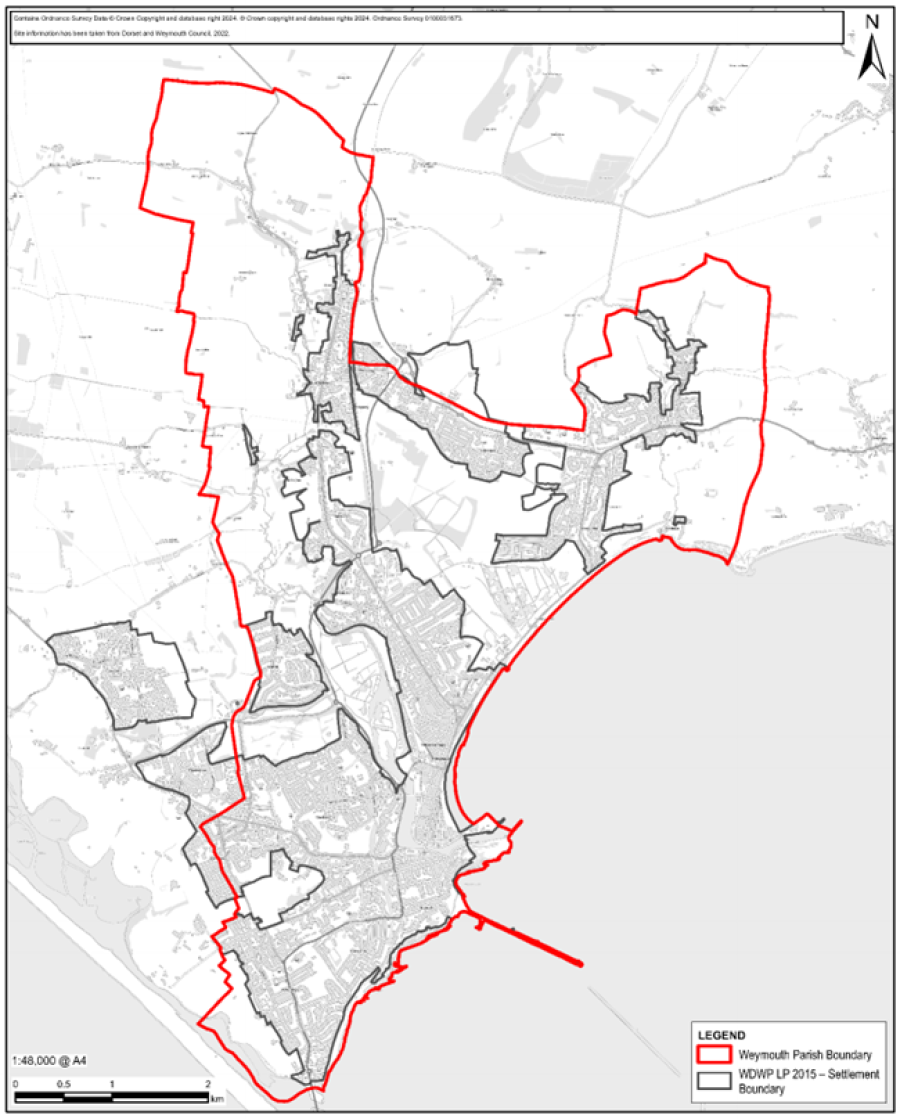
9.19 To further direct development the Local Plan includes defined development boundaries for Weymouth, within which residential, employment and other development to meet the needs of the local area will normally be permitted. Map 16 brings the proposed Defined Development Boundaries (DDB) more up to date, since the Local Plan’s adoption in October 2015, by reflecting the proposed site allocations within this Neighbourhood Plan at Wyke Oliver Farm (W20) and Redlands Farm (W21). Dorset Council will need to update the Defined Development Boundary to include land developed since 2015 such as Land at Markham and Little Francis.
9.20 Policy W14 endorses the principle of a defined development boundary (DDB) as a device to focus development and generally protect the more environmentally sensitive and significant parts of the neighbourhood area. The defined development boundaries for the neighbourhood area are based on a set of criteria to identify which areas are built-up and demarcate them from areas where the countryside and related restrictive policies may apply.
9.21 Within the DDB there is a presumption in favour of sustainable development if it conforms with relevant policies in the development plan. In countryside areas, i.e. on land outside the DDB, unless land is specifically allocated or identified for development, development must accord with the restrictive policies in the development plan. Any development proposals that are considered permissible should be accompanied by a Landscape and Visual Impact Assessment to establish that there will be no adverse visual impact on the character and sensitivity of the landscape.
9.22 The policy will align with the relevant environmental targets and objectives as shown in the table below.
| Policy W14: Relevant Environmental Targets | |
|---|---|
| Objective 1: | Carbon Neutrality Targets 5, 7 |
| Objective 2: | Resource Efficiency Targets 11, 12, 14, 15, 16 |
| Objective 3: | Biodiversity Net Gain Targets 23 |
| Objective 4: | Climate Change Management Targets 26, 31 |
Policy W15: Extensions and Alterations
1. Extensions, and alterations to a building that require planning consent, should be designed to the highest sustainability standards and reflect the character of nearby buildings and their setting. This will require particular attention to:
2. Measures to improve the sustainability of a building, including retrofitting to increase its energy efficiency and the appropriate use of micro-renewables, are encouraged.
3. Proposals should demonstrate due regard for the design guidance relating to the location of the development.
9.23 The significance of design and character should apply not just to new buildings but to additions and alterations to existing ones.
9.24 Policy ENV12 of the Local Plan requires that any alterations to or extensions of buildings should be well related to, and not overpower, the original building or neighbouring properties, unless they achieve significant visual enhancement to both the building and surrounding area.
9.25 Policy W15 requires owners and developers of properties in Weymouth who are considering altering a property to the extent it requires planning permission, to also have regard to the suitability and sustainability of the design and construction proposals.
9.26 Whether designing a new extension, or retrofitting an existing building, consideration should be given to utilising Passive House principles; materials with low embodied energy and/or a high thermal mass; green roofs or walls; photovoltaics or solar thermal water heating; water efficiency measures; ground or air source heat pumps for heating; and low flow technology in water fittings. The sourcing of local materials and use of recycled materials is encouraged.
In the case of heritage properties proposals should accord with policy W19 and the retrofitting criterion of policy W37.
9.27 Developers should refer to the design guidance available from Dorset Council and any locally approved design statements and historic buildings, as well as Historic England’s guidance on the sensitive retrofitting and energy efficiency of historic buildings68.
Policy W16: Major Housing Sites
1. In the interests of ensuring that the development of major housing sites in the neighbourhood area meets the needs of the communities and contributes significantly to increasing community resilience, their development should provide for:
2. Development proposals should take account of the concept of ‘Walkable Neighbourhoods’ and include links to new or existing community facilities that will promote walking, cycling and sustainable transport.
3. Where appropriate, applications should be accompanied by an appropriate Landscape and Visual Impact Assessment, a site-specific flood risk assessment, detailed drainage proposals, a transport impact assessment and travel plan, a noise assessment and an archaeological assessment, to demonstrate that the development is acceptable or to provide appropriate mitigation measures.
4. A Drainage Impact Assessment will be required for all new development with potentially significant surface run-off implications.
5. To mitigate adverse effects on the integrity of the Chesil Beach and The Fleet SAC regarding in-combination recreational pressure, any development proposals that provide for a net increase in the population must make adequate financial payments in accordance with the interim mitigation strategy for the SAC. A financial tariff will be required for all such proposals within 5km of the European site, in line with Natural England advice. This policy aligns with the aims of Policy ENV2 of the adopted Local Plan, which centres on the protection of Habitats sites.
6. Developments are carefully designed and planned to ensure that no adverse effects on the integrity of Habitats sites occur as a result of water pollution stemming from site run-off or dust emissions during construction or the operational stage of each of the developments.
9.28 Policy W16 recognises the impact that major69 housing developments can have on the area and the quality of life of our citizens. The community’s response to consultations included a critique of recent housing developments and what were considered essential aspects of a 21st century housing environment.
9.29 The NPPF (para. 116) encourages us to ensure that housing development achieves high space standards, and helps to "create places that are safe, secure and attractive, which minimise the scope for conflicts between pedestrians, cyclists and vehicles, avoid unnecessary street clutter, and respond to local character and design standards. It also encourages layouts that allow for the efficient delivery of goods, access by service and emergency vehicles, and enable charging of plug-in and other ultra-low emission vehicles in safe, accessible and convenient locations".
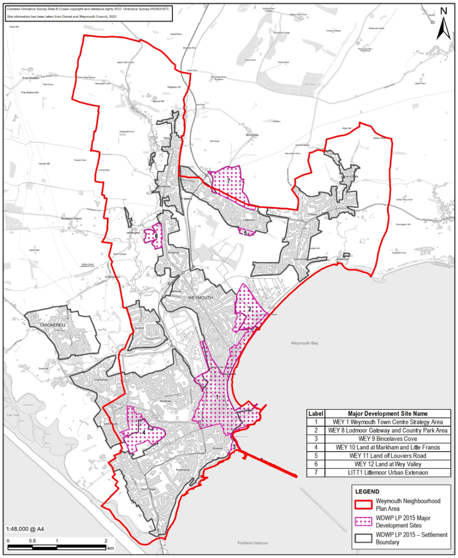
9.30 Policy W16 applies to all major residential development sites in the neighbourhood area, including the strategic housing sites identified in the Local Plan (see Map 17). It seeks to establish consistency of standards, quality, and sustainability to provide a high-quality living environment. Major housing developments are also expected to make a significant contribution to meeting local needs and demands by adhering to the housing mix and affordable housing policies in the Neighbourhood Plan. Map 17 does not show the following allocations: WEY13 – Land at Old Rectory, Lorton Lane; WEY15 – Land at Tumbledown Farm; and WEY16 – Lorton Valley Nature Park.
9.31 A walkable neighbourhood is one that is designed to promote walking, cycling and sustainable transport by ensuring that services and amenities are accessible within a short distance. The concept originated as a model of urban development and is recognised globally. For the purposes of the Neighbourhood Plan, a reasonable definition would be a neighbourhood characterised by having a range of predominantly day-to-day facilities within 800 metres where possible. Strong support has been expressed for this concept during public engagement. Developers of larger residential sites are encouraged to embrace the concept and include appropriate links and routes.
9.32 In October 2019 Weymouth Town Council adopted the Rambler’s Charter for Walking Neighbourhoods70. These objectives apply to major developments. The Charter sets out five objectives:
9.33 The policy will align with the relevant environmental targets and objectives as shown in the table below.
| Policy W16: Relevant Environmental Targets | |
|---|---|
| Objective 1: | Carbon Neutrality Targets 3, 5 |
| Objective 3: | Biodiversity Net Gain Targets 22 |
| Objective 4: | Climate Change Management Targets 27, 28, 31 |
Policy W17: Housing Mix
New residential development should provide or contribute to a mix of housing tenure types and sizes to help maintain mixed, balanced and inclusive communities within the neighbourhood plan area. The proposed housing mixes on major sites should be based on an up-to-date local housing needs analysis.
9.34 The NPPF (para. 63) says "the size, type and tenure of housing needed for different groups in the community should be assessed and reflected in planning policies".
9.35 Policy W17 seeks to ensure that new housing development is relevant and contributes to providing a mix of dwelling tenures, types, and sizes that will satisfy local needs and demands, including for down-sizing. This should apply whether the development is for affordable housing or open-market dwellings or a mix.
9.36 The 2024 Housing Needs Analysis, in contrast, suggests that the biggest demand is for 4-bed dwellings. However, the report does discuss the need for smaller dwellings to meet local housing needs, particularly affordable housing requirements. This is supported by the Housing Register figures detailed in 9.6, reinforcing the conclusion of the 2021 report that new dwelling stock should provide a mix of all sizes but primarily deliver 2 or 3-bed homes.
9.37 Policy W17 requires residential development proposals to provide justification for the housing mix on the site. The Weymouth Neighbourhood Plan Housing Needs Assessment 2021 "advises that over the plan period, the greatest increase in housing stock in Weymouth is required in middle-sized homes of three and two bedrooms (48% and 35% respectively), with only minor additions of 7–9% needed in the smaller and larger one- and four-bedroom categories. The lowest increase is required in the largest five-or-more bedroom category (0.5%). Therefore, new dwelling stock should provide a mix of all sizes of properties but primarily deliver 2–3 bedroom properties".
9.38 At the time of making a planning application for a major development site, the most recent assessment of local housing need, acceptable to the local planning authority, should be used as the starting point for judging the housing mix. In making any judgement, consideration will also be given to whether the assessment remains relevant and whether there are any strategic or local circumstances that may justify a different housing mix. Developers should seek advice from Dorset Council’s Housing Enabling Team on how to establish the appropriate housing mix for their site.
Policy W18: Affordable Housing
1. Weymouth Town Council is committed to maximising the provision of dwellings that are affordable and accessible to local people over the plan period.
2. Proposals for housing and mixed-use developments, other than replacement dwellings, within the defined development area boundaries that result in a net increase of ten or more units or sites greater than 0.5 ha will be subject to the following criteria:
3. Any affordable housing provision should demonstrate the following:
4. Affordable housing should be provided in perpetuity, in accordance with the most up-to-date Government policy, for example through a Community Land Trust, section 106 agreements, other community housing schemes or a Registered Provider which retains stock for the benefit of the local community at an accessible cost.
5. Proposals for housing and mixed-use developments that result in between 2 and 9 units on sites of less than 0.5 ha will provide up to 35% affordable homes or the commuted sum equivalent to the Local Authority for development of affordable homes in the Weymouth area, subject to a Financial Viability Assessment to determine the precise amount.
9.39 The Weymouth Housing Needs Analysis 2021 identified a chronic need for affordable homes. The need is driven by high prices and rents and low incomes for many people in Weymouth. The Analysis Report estimates a requirement of between 1,775 and 2,649 affordable homes over the period 2021 to 2038. This need would be best met by a tenure split favouring rented dwellings, with up to 70% rented (either social or affordable rent), and the balance for ownership including First Homes, discounted market sale, and shared ownership. The greatest need over the next few years will be for 3-bed and 2-bed dwellings at 48% and 35% respectively. The forward need for 1-bed dwellings is estimated to be less than 10%. The updated HNA 202471 shows a need for 242 affordable homes per annum, equating to 4,114 homes.
9.40 Policy HOUS1 of the Local Plan, adopted in 2015, required 35% of dwellings on major sites to be affordable, subject to viability72. However, the Local Plan has not delivered the required proportion of affordable dwellings. Between 2016 and 2021, of the 1,069 homes completed in Weymouth and Portland, only 160 homes (15%) were affordable. None of these were completed on exception sites. A combination of viability constraints and small site development is considered to be the cause.
9.41 The neighbourhood planning process has been used to explore ways to address the issue and ensure future housing development in the neighbourhood area delivers a much higher number and proportion of affordable dwellings. The site analysis and consultation undertaken based on the Site Assessment and Options Paper73 focused on meeting the community’s housing objectives of:
These are reflected in the housing development and site allocation policies in the Neighbourhood Plan.
9.42 Policy W18 requires developers to prioritise and maximise the provision of affordable dwellings. In view of the local housing crisis, the requirement of 35% affordable housing on major development sites within defined development boundaries, and 50% on greenfield sites, is considered reasonable. Developers are encouraged to maximise the proportion of affordable homes. Such dwellings should not be readily differentiated from open market homes in terms of design, quality, location, and distribution within a site.
9.43 The balance of type, size, and tenure of affordable housing on each site should be determined based on the most current evidence available at the time of the planning application. Reference should be made to the Dorset housing register, Dorset Council’s Housing Enabling Team, and any local surveys. Weymouth Town Council should also be consulted. The Local Plan consultation suggested a 50:50 split between social rent and affordable rent, while local evidence indicates a 60:40 split in favour of social renting74.
9.44 A Local Connection policy prioritising Weymouth residents and key workers is considered necessary due to the shortage of affordable homes, overcrowding, and the movement of young people away from the area. Residents have expressed a strong need for affordable housing for local people, particularly young families on low incomes. Without such provision, young people are likely to remain in the family home for extended periods. Employers have also indicated that high housing costs are affecting recruitment, particularly for lower-paid roles. Key workers are defined in government guidance (EIM21375). Dorset Council is expected to consider this in future updates to the Housing Allocation Policy.
9.45 First Homes should account for at least 25% of all affordable housing units delivered through planning obligations. First Homes are typically discounted market sale units but may include other tenures where local need is identified. First Homes must be discounted by a minimum of 30% against market value, sold to eligible first-time buyers within the local area intending to live in the property, and include a restriction to ensure the discount is retained in future sales. After discount, the first sale price must not exceed £250,000.
9.46 The Purbeck Local Plan 202475 Policy H11 provides for a commuted sum to be paid on sites unable to provide affordable homes on site. This applies to new build developments of between 2 and 9 homes.
Policy W19: Site Allocations
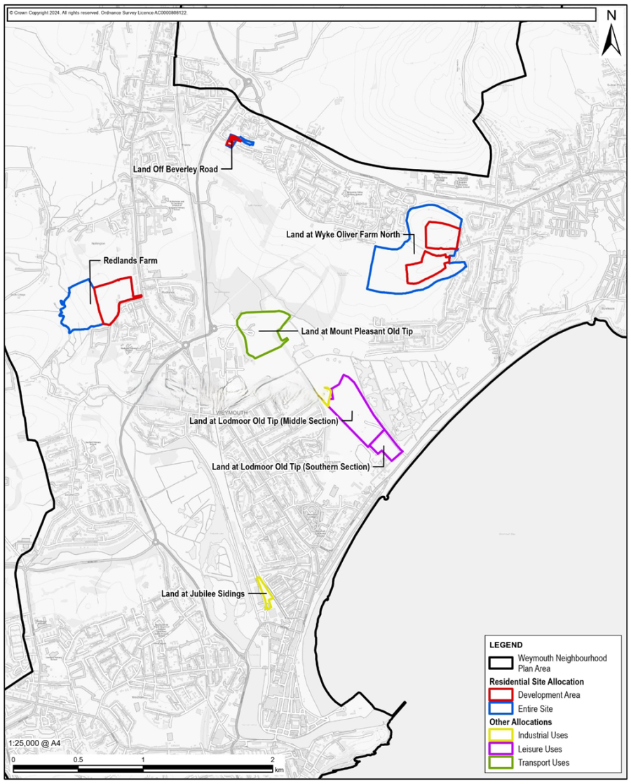
The following sites are allocation as allocated on Map 18 and defined in Table B and specified within the detailed Allocation Policies:
W20: Land at Wyke Oliver Farm North - Residential
W21: Land at Redlands Farm - Residential
W22: Land off Beverley Road - Residential
W23B: Lodmoor Old Tip Mid - Leisure
W23C: Lodmoor Old Tip South - Leisure
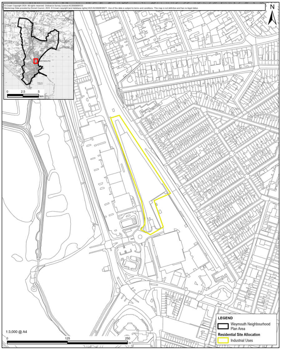
W24: Land at Jubilee Sidings - Employment / Training & Housing
W25: Mount Pleasant Old Tip - Transport
9.47 The selection of development sites for the Neighbourhood Plan has been a thorough, extensive, and conventional process, carried out with the guidance of professional advisors and overseen by the local planning authority. Sites have been allocated to supplement or add detail to those identified in the existing Local Plan, to meet the aims and objectives of the Neighbourhood Plan. The number of sites and the basis of allocation has changed as the process has progressed.
9.48 We are encouraged by the NPPF (para. 71) to “give particular consideration to the opportunities for allocating small and medium-sized sites suitable for housing in their area” The NPPF (para 74) requires consideration of employment and transport allocations. These considerations are highlighted (NPPF para 90) when considering towns.
9.49 In 2021 a call for sites was made, followed by a comprehensive assessment of 61 tracts of land within the neighbourhood area to consider their suitability for development and potential environmental impact. This included 11 sites submitted through a local call for sites, along with sites identified through the local planning authority’s SHLAA process. All 61 sites were given detailed consideration. Landowners were notified and site availability was confirmed. The sites were independently assessed by AECOM, and the findings were reported to the Steering Group. The assessment concluded that 33 sites were potentially suitable for residential development, subject to overcoming identified constraints.
9.50 Based on the Site Options Assessment Report, a shortlist of potentially suitable development sites was endorsed by the Steering Group and consulted on during the 3rd and 4th community consultations 76/77 in 2023. In parallel, alternative development strategies were assessed through an interim Strategic Environmental Assessment (SEA) to evaluate potential environmental impacts. This process aimed to maximise the Neighbourhood Plan’s contribution to sustainable development. To address the potential shortfall in affordable housing, sites outside the Defined Development Boundary were also considered. Discussions were initiated with landowners, their representatives, and development partners.
9.51 The response to the surveys and studies carried out in 2023 enabled the Steering Group to reach conclusions on a preferred development strategy. This formed the basis for the Regulation 14 Pre-Submission Consultation, which included responses from statutory authorities and local residents.
9.52 The selection of sites to be allocated in the Neighbourhood Plan was made following an independent assessment of options. The SEA Environmental Report78 was produced on behalf of the Steering Group by AECOM. An interim release assessed reasonable alternatives as follows:
9.53 The assessment concluded that development within the Defined Development Boundary (DDB) should focus on Option E, which encourages a range of uses within the DDB and considers proposals on a case-by-case basis. The report further suggested that developing sites outside the DDB would have ‘uncertain effects’ and ‘negative effects’, but that to achieve the Weymouth Neighbourhood Plan objectives, such sites should still be taken forward, with policies addressing the associated concerns and constraints. Finally, the report recommends that a Principal Residency policy would support the local transport network by improving sustainable transport and maintaining the viability of public transport options, and would avoid increases in traffic, particularly in summer months, by not limiting non-principal residency. Through this approach, the SEA for the Weymouth Neighbourhood Plan seeks to maximise the Plan’s contribution to sustainable development.
9.54 The criteria of the individual allocation policies that follow reflect the need to address the identified development constraints of each site and ensure that the resulting development is suitable, sustainable, and beneficial for the neighbourhood area, as well as satisfying the requirements of NPPF para. 135, which states that developments should:
9.55 The responses from statutory authorities, landowners, and residents to the Regulation 14 Consultation have been analysed. There were both positive and negative responses to the Plan. Most of the negative responses related to site allocations. Where these responses highlighted legitimate planning concerns, they have been evaluated and the policies amended accordingly. This has resulted in changes to the site allocations and the planned uses of land, as summarised below and reflected in Table B and Map 18.
9.56 To meet the local affordable housing need, three sites are allocated on greenfield land across 16.7 hectares, providing 425 homes, including 212 affordable homes (70% for rent and 30% for purchase). The loss of greenfield land is compensated by allocating 31.9 hectares of adjacent land for public open space or inclusion within the Lorton Valley Nature Park. This helps preserve green gaps and wildlife corridors between Littlemoor and Preston, and between Radipole, Nottington, and Redlands. The viability of delivering these sites with 50% affordable housing has been demonstrated.
9.57 However, viability testing also showed that developing brownfield sites to include affordable housing is more challenging and requires additional funding. Consequently, and taking into account concerns about flood risk (Flood Zone 3), the site at St Nicholas Street has not been allocated in this plan. It is hoped that, through Levelling Up funding, this and other brownfield sites in the town centre will come forward for development including significant levels of affordable housing. Without this, the Local Plan and Neighbourhood Plan will not fully meet the affordable housing needs in Weymouth. Nevertheless, this plan reduces the shortfall by 212 homes.
9.58 The viability testing also assessed small-scale development of the Lodmoor Old Tip mid section. This indicated that, from a cost perspective, there is potential for viable development of housing and some leisure uses. However, the cost of relocating the Household Waste Recycling Centre was not evaluated.
9.59 Concerns were raised regarding the development of the Lodmoor Tip, including flood risk, land contamination, and proximity to Lodmoor SSSI and SNCI. Dorset Council has emphasised that the Lodmoor Tip largely falls within the boundary of WEY8 Lodmoor Gateway and is identified for leisure use. In addition, relocating the Household Recycling Centre is unlikely. Consequently, W23B and W23C are allocated for leisure use. Note that site W23A (Lodmoor Tip North) was deleted at examination.
9.60 It has been difficult to identify sites suitable for employment use. W24 Jubilee Sidings Extension remains allocated, while W23A was removed at examination by the appointed planning inspector. The key employment site allocated in the Local Plan has been reduced by retail development, leaving only 0.7 hectares undeveloped. It is hoped that the Levelling Up Fund will support further employment opportunities in the town centre, and that the Local Plan will deliver 5 hectares of key employment land at the Littlemoor Northern Expansion (LITT6).
Table B Site Allocations Summary
| Site | Policy | Allocation | Total Size ha | Dev’t size ha | Homes | Site Allocations details | Affordable Homes | Green Space |
|---|---|---|---|---|---|---|---|---|
| Land at Wyke Oliver Farm | W20 | Residential & LVNP | 33.32 | 9.42 | 250 | Mixed Residential Homes 50% Affordable, Land at LVNP and community Space | 125 | 23.1 |
| Redlands Farm | W21 | Residential & Public Space | 15.4 | 6.6 | 150 | Mixed Residential 50% Affordable | 75 | 8.8 |
| Off Beverley Road | W22 | Residential & Local Green Space | 1.25 | 0.7 | 25 | Dwellings at least 50% Affordable contribution to Local Green Space | 12 | 0.55 |
| Lodmoor Old Tip Mid | W23B | Leisure | 13.1 | 0 | 0 | Leisure | 0 | 13.1 |
| Lodmoor Old Tip South | W23C | Leisure | 2.2 | 0 | 0 | Leisure possibly indoor | 0 | 2.2 |
| Land at Jubilee Sidings | W24 | Mixed Use: Employment/Training & Housing | 2 | 2 | tbd | Multi-storey development for Employment/Training & Housing | tbd | 0 |
| Mount Pleasant Old Tip | W25 | Mixed Use: Transport, Leisure & Renewable | 11.3 | 3.82 | 0 | Re-vamp Park & Ride as transport interchange facility, encourage leisure use | 0 | 7.48 |
| Total | 78.15 | 22.54 | 425 | 212 | 54.76 |
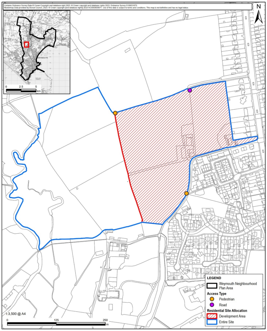
Policy W20: Land at Wyke Oliver Farm North
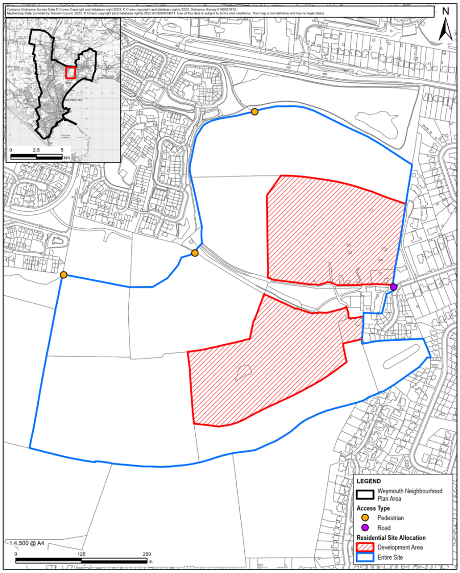
9.61 The area of land defined on Map 19 has been identified as a preferred residential development site, because of its availability, developability, and suitability to meet local housing needs. The site assessment process has shown the site is potentially suitable for allocation for residential development.
9.62 The Site Assessment identified development constraints including the nearby Dorset Natural Landscape area to the north and Lorton Valley Nature Reserve to the south, limited vehicular access opportunities, the Gas Pipeline Safeguarding Corridor on the western edge, and a small part of the site lying within Flood Zone 2.
9.63 Following a robust analysis and selection process, including community consultations and discussions with landowners and development partners, the land defined on Map 19 is allocated by Policy W20 for residential development of around 250 dwellings.
9.64 The area allocated for residential development is the part of the wider site that will be least visually intrusive. To ensure this, Policy W20 requires retention of existing hedgerows wherever possible and a landscaping scheme that maintains the overall rural character of the location.
9.65 The layout of the development should respond to its setting by including both public and private green spaces, community horticulture opportunities, a network of tree-lined routes, access to the countryside, and links to the nearby Lorton Valley Nature Reserve.
9.66 The surface water management strategy must include the following:
9.67 The network of cycleways and footpaths should be planned to encourage non-motorised travel within the site and to community facilities and amenities beyond it. A significant community focus is considered an important element of the development to help create and support a new community. Community focus refers to providing a focal point or facility where residents can meet and interact. As part of the master planning, the developer should assess what type of community focal point would best enhance the development. This could include a covered meeting place (potentially over the gas pipeline area), provision for a local business, healthcare facilities such as a doctor or dentist, a bus turning point, or an e-bike parking area.
9.68 As part of the master-planning process, a site-specific design code should be agreed with the Local Planning Authority. This should set detailed parameters for development that align with Policy W20 and ensure that the design quality and style are appropriate to the location.
9.69 The provision of around 250 dwellings on land at Wyke Oliver Farm North should make a significant contribution to local housing needs over the plan-period. The required 50% proportion of affordable dwellings and the mix of tenures is based on a viability assessment that has been independently conducted.79 This report shows that the site is viable with 50% Affordable Homes, CIL, S106 of £13,000 by a margin of £500K.
9.70 The transfer of ownership of 23ha of land to a suitable public body, such as Dorset Wildlife Trust, as part of Lorton Valley Nature Park, identified on Map 19, shall be agreed with the Dorset Council.
9.71 The policy will align with the relevant environmental targets and objectives as shown in the table below.
| Policy W20: Relevant Environmental Targets | |
|---|---|
| Objective 1: | Carbon Neutrality Targets 1-8 inclusive |
| Objective 2: | Resource Efficiency Targets 9, 10, 11, 12, 13, 14, 15, 16, 19 |
| Objective 3: | Biodiversity Net Gain Targets 22, 23, 24, 25 |
| Objective 4: | Climate Change Management Targets 26, 27, 28, 29, 30, 31 |
Policy W21: Land at Redlands Farm
9.72 The area of land defined on Map 20 has been identified as a preferred residential development site due to its availability, developability, and suitability to meet local housing needs. The site assessment process has shown that the site is potentially suitable for allocation for residential development, subject to identified constraints being addressed.
9.73 The Site Assessment identified development constraints including the need to minimise landscape impact and existing access restrictions. The main road access to the site is likely to be from the development to the north.
9.74 Following a robust analysis and selection process, including community consultations and discussions with landowners and development partners, the land defined on Map 20 is allocated by Policy W21 for residential development of around 150 dwellings.
9.75 The 6.6ha site comprises three fields and a strip of land adjacent to Corfe Hill Lane extending to Dorchester Road. The site adjoins a substantial residential development to the north and sites with planning permission to the south. Its design and layout should generally harmonise with nearby developments while establishing its own character and style, as is typical in the Weymouth area.
9.76 The wider area, particularly to the west of the development site, is rich in wildlife and must be protected. The layout and design should retain and incorporate as many trees and hedgerows as possible and include appropriate landscaping and boundary treatments to minimise visual impact and enhance biodiversity through the creation of wildlife habitats and corridors.
9.77 The network of cycleways and footpaths should be planned to encourage non-motorised travel within the site, provide access to the countryside to the west, and connect to community facilities and amenities beyond the site.
9.78 The surface water management strategy must include the following:
9.79 As part of the master-planning process, a site-specific design code should be agreed with the Local Planning Authority, setting detailed parameters that align with Policy W44 and ensure the style and quality of development are appropriate to its location.
9.80 The provision of around 150 dwellings on land at Redlands Farm should make a significant contribution to local housing needs over the plan-period. The required proportion of affordable dwellings and the mix of tenures is based on a viability assessment that has been conducted on this site demonstrating that 50% Affordable Home is viable.80 This report shows that the site is viable with 50% Affordable Homes, CIL, S106 of £13,000 by a small margin and notes that the coverage of the scheme is unusually low.
9.81 The transfer of ownership of 8.8ha of land to the west to provide for public open space and an extended Area of Nature Conservation shall be agreed with Dorset Council, the local planning authority.
9.82 The policy will align with the relevant environmental targets and objectives as shown in the table below.
| Policy W21: Relevant Environmental Targets | |
|---|---|
| Objective 1: | Carbon Neutrality Targets 1-8 inclusive |
| Objective 2: | Resource Efficiency Targets 9-15 inclusive, 19 |
| Objective 3: | Biodiversity Net Gain Targets 23, 23, 24, 25 |
| Objective 4: | Climate Change Management Targets 26-31 inclusive |
Policy W22: Land off Beverley Road, Littlemoor
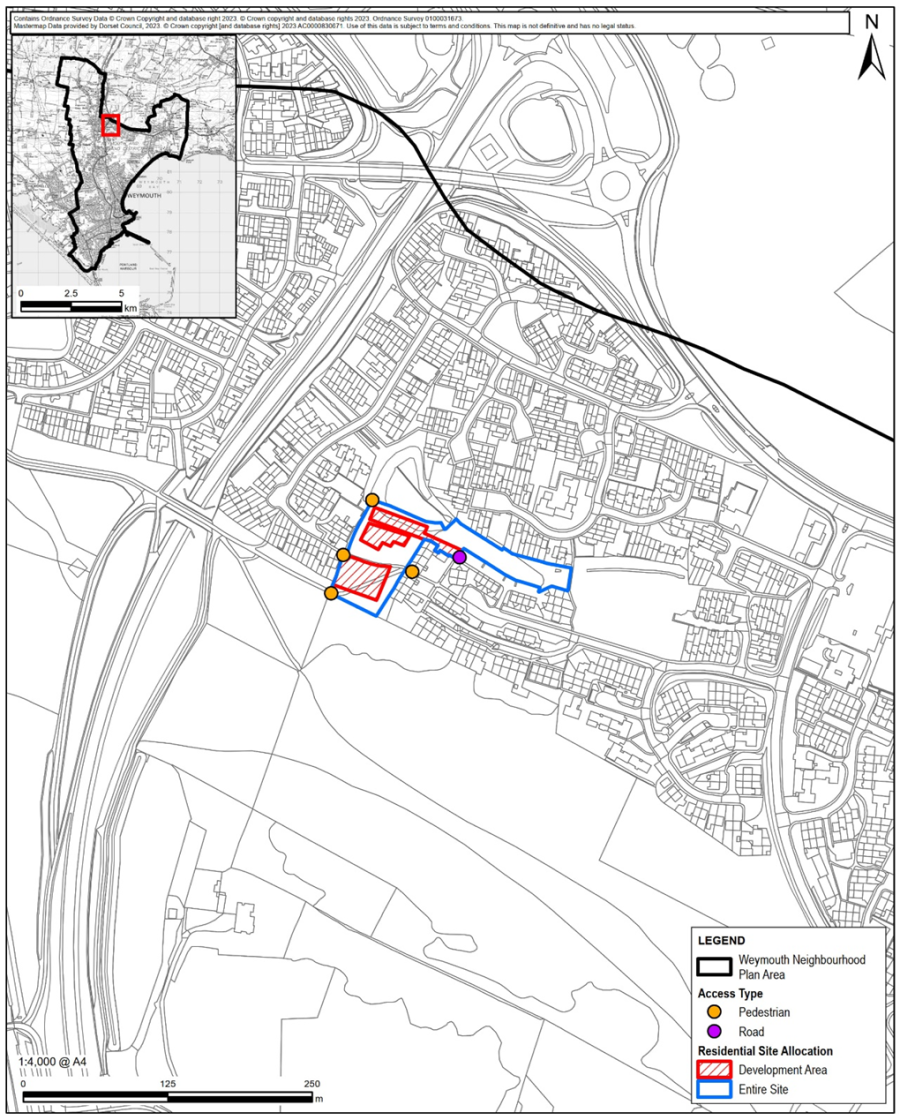
9.83 The area of land defined on Map 21 has been identified as a preferred residential development site due to its availability, developability, and suitability to meet local housing needs. The site assessment process has shown that the site is potentially suitable for allocation for residential development.
9.84 The Site Assessment identified development constraints including the lack of existing access to the site, steeply rising land that may require earthworks, and the potential loss of ecologically valuable green space and mature trees. However, the site benefits from being within the defined development boundary (DDB) and is conveniently located close to schools, a local shopping hub, a dentist, and doctors. It is likely that road access will be from the car park adjacent to the block of flats on Beverley Road.
9.85 Following a robust analysis and selection process, including community consultations and discussions with landowners and development partners, the land defined on Map 21 is allocated by Policy W22 for residential development of around 25 dwellings in an area where additional housing is needed.
9.86 The site is currently a valued local amenity space with mature trees and is crossed by two well-used community paths. Policy W22 requires the incorporation of landscaped public routes within the development and the inclusion of a significant area of public open space. The development must also recognise the compatible local green space designation (reference LGS18). Through a Sustainable Urban Drainage System, the development should address impacts on the stream to the north of the site.
9.87 The surface water management strategy must include the following:
9.88 The topography of the site is significant and should influence the design and layout of the development, including the relative height of buildings.
9.89 The proportion of affordable housing and tenure mix is based on a viability assessment conducted for the site81. This indicates that the development is viable with 50% affordable housing, Community Infrastructure Levy (CIL), and Section 106 contributions of £9,500 per unit, assuming that standard Section 106 requirements are reduced by the Local Planning Authority in recognition of the delivery of much-needed affordable homes.
9.90 The policy will align with the relevant environmental targets and objectives as shown in the table below.
| Policy W22: Relevant Environmental Targets | |
|---|---|
| Objective 1: | Carbon Neutrality Targets 1-8 inclusive |
| Objective 2: | Resource Efficiency Targets 9-16 inclusive, 19 |
| Objective 3: | Biodiversity Net Gain Targets 22-25 inclusive |
| Objective 4: | Climate Change Management Targets 26-31 inclusive |
Policy W23A: Lodmoor Old Tip – North Section
This policy, supporting text and map 22A has been removed from the plan as a result of the Examiner’s recommendations.
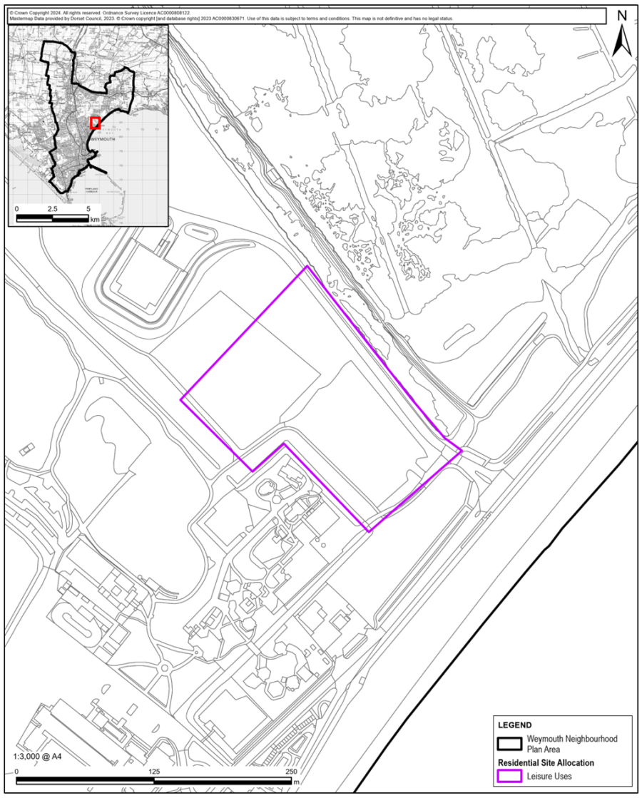
Policy W23B: Land at Lodmoor Old Tip – Mid-Section
The land forming Lodmoor Old Tip mid-section as identified in blue on Map 22B is allocated for leisure use in accordance with the Local Plan Policy WEY8.
9.91 The area of land defined on Map 22B has been identified as a preferred leisure development site due to its availability, developability, and suitability to meet local needs. The site assessment process has indicated that the site is potentially suitable for a café or viewing centre for the Lodmoor Bird Reserve.
9.92 The site includes the Household Recycling Centre and the temporary grass cutting storage area. It is approximately 3–4 metres higher than the surrounding land, having previously been used as a landfill site for Weymouth. The site is crossed by a permissive path and much of it is covered in scrub. It is bounded on the western and eastern sides by drainage dykes.
9.93 The site falls within the West Dorset, Weymouth & Portland Local Plan and forms part of WEY8 Lodmoor Gateway, which states that any development should be of high-quality design and relate positively to adjoining public areas. The site lies outside the adjacent Lodmoor SSSI and Lodmoor SNCI and is also outside the defined development boundary.
9.94 Access to the site is from Preston Beach Road using the existing access road serving the Household Recycling Centre and the temporary grass cutting storage area.
9.95 The Final SEA Report assesses the environmental impact of the site and raises concerns regarding impacts on biodiversity and geodiversity. It also notes potential positive benefits to community well-being and remains inconclusive regarding impacts on climate change, resources, and landscape. These concerns will need to be addressed through development proposals.
9.96 The development is required to comply with all relevant Neighbourhood Plan policies.
9.97 The policy will align with the relevant environmental targets and objectives as shown in the table below.
| Policy W23B: Relevant Environmental Targets | |
|---|---|
| Objective 1: | Carbon Neutrality Targets 1-8 inclusive |
| Objective 2: | Resource Efficiency Targets 9-16 inclusive |
| Objective 3: | Biodiversity Net Gain Targets 22-25 inclusive |
| Objective 4: | Climate Change Management Targets 26-31 inclusive |
Policy W23C: Lodmoor Old Tip South Section
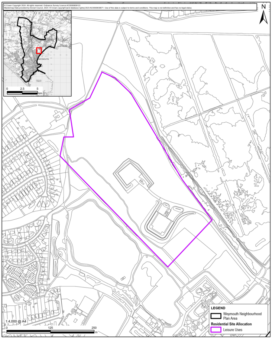
9.98 The area of land defined on Map 22C has been identified as a mixed site for leisure use due to its availability, developability, and suitability to meet local recreation and tourism needs.
9.99 The site was previously used as a landfill. This southern section largely comprises the Preston Beach car park and overflow parking area. While the land itself is not within Flood Zone 2 or 3, it is surrounded by land within Flood Zone 3. The site lies within the West Dorset, Weymouth & Portland Local Plan and forms part of WEY8 Lodmoor Gateway and Country Park Area, which states that development should be of high-quality design and relate positively to adjoining public areas. The site is separated from adjoining public areas by a dyke and is connected by permissive paths. It lies outside the adjacent Lodmoor SSSI and outside the defined development boundary.
9.100 The Site Options and Assessment study identified the site as potentially suitable for residential allocation. However, there are constraints including two operational waste sites to the north safeguarded in the 2019 Waste Plan, potential ground contamination due to its former use as a landfill, and a former liquid waste facility in the northern part of the site. Remediation and ground stabilisation may increase development costs. Consultation with Dorset Council would also be required to determine the extent to which the existing car park should be retained, as it serves the beach, the RSPB reserve, and complements the larger car park within Lodmoor Country Park.
9.101 Access to the site is from Preston Beach Road using the existing service road to the Lodmoor Beach car park.
9.102 The site is best suited to provide additional employment opportunities linked to leisure uses, including new visitor attractions, pop-up camping, or campervan parking.
9.103 The Final SEA Report identified no adverse effects and noted positive impacts for community well-being and transportation. However, it identified uncertainty regarding impacts on biodiversity, geodiversity, and climate change. These uncertainties will need to be addressed in any development proposals.
9.104 The policy will align with the relevant environmental targets and objectives as shown in the table below.
| Policy W23C: Relevant Environmental Targets | |
|---|---|
| Objective 1: | Carbon Neutrality Targets 1-8 inclusive |
| Objective 2: | Resource Efficiency Targets 9-16 inclusive |
| Objective 3: | Biodiversity Net Gain Targets 22-25 inclusive |
| Objective 4: | Climate Change Management Targets 26-31 inclusive |
Policy W24: Land at Jubilee Sidings
9.105 The site shown on Map 23, Jubilee Sidings, is within the Defined Development Boundary.
9.106 The Site Options and Assessment Study identified the site as potentially suitable for residential and/or employment allocation. There is potential for ground contamination associated with previous uses. Redundant railway tracks run along the western boundary of the site, although these are no longer in use. Mitigation may be required for noise arising from neighbouring uses.
9.107 The site is considered suitable for employment use due to its central location, good rail access, and proximity to surrounding retail, office, and light industrial units in Jubilee Retail Park. It is also considered an appropriate location for skills training because of its access to public transport. Additionally, the site is suitable for residential development, with potential for four to five storey buildings providing high-density accommodation, including a significant proportion of affordable flats or apartments, particularly for social housing.
9.108 Following a robust analysis and selection process, including community consultations and discussions with landowners and development partners, the land defined on Map 23 is allocated by Policy W24 for mixed-use development, generally in accordance with Policy W39.
9.109 The location of the site enables it to make a significant contribution to meeting specialist local housing needs over the plan period.
9.110 The mix of non-residential uses should clearly serve local employment-related needs. Retail development should be limited to uses that support the development itself and the surrounding local area.
9.111 The road access to the site lies within Flood Zone 3 and is therefore at risk of occasional flooding. Development must ensure safety throughout its lifetime, including safe access and evacuation routes during flood events. It should be noted that pedestrian access is available from the north via the Alexandra Road Bridge over the railway line.
9.112 The surface water management strategy must include the following:
9.113 The Jubilee Sidings site was assessed as part of the viability testing. This concluded that a market-led development would only be viable without affordable housing, whereas a 100% rented affordable housing scheme could be viable with grant support of £55,000 per unit, potentially available through Homes England funding.
9.114 The site owner may consider redeveloping a wider area, which could improve overall development viability.
9.115 The policy will align with the relevant environmental targets and objectives as shown in the table below.
| Policy W24: Relevant Environmental Targets | |
|---|---|
| Objective 1: | Carbon Neutrality Targets 1-8 inclusive |
| Objective 2: | Resource Efficiency Targets 9-16 inclusive, 19 |
| Objective 3: | Biodiversity Net Gain Targets 22-25 inclusive |
| Objective 4: | Climate Change Management Targets 26, 31 |
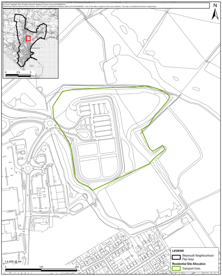
Policy W25: Land at Mount Pleasant Old Tip – Transport Interchange
9.116 The site identified on Map 24 was put forward as a potential development site in response to the Call for Sites associated with the preparation of the Neighbourhood Plan. It includes an existing Park and Ride facility, which sits within the site and was developed when the Weymouth Relief Road was constructed in 2011. The Site Options Assessment Report assessed the site as unsuitable for either residential or employment use.
9.117 The Park and Ride scheme fell into dis-use with First Bus no longer providing a service within the Park and Ride. Weymouth Town Council has proposed revitalising the Park and Ride scheme and has encouraged a private operator to provide a summer peak time service. This relieves congestion in town and pressure on the Town Centre car parks.
9.118 Policy W25 supports a scheme to bring the site back into full use, as a vital transport interchange facility that could have a major impact on transport use and activity in the area. The site is sufficiently large to accommodate a variety of compatible uses including a modern transport hub, nature restoration area and sports and recreation facilities. The primary use should remain as the Weymouth Park and Ride, which needs to have a service bus for the peak summer period. The site is near to the National Cycle Route 26 and is linked by dual-use paths to the surrounding area and so provides links to the beach and the nature and conservation areas nearby.
9.119 Dorset Council supports bringing the site back into full use, as a mobility hub. We envisage a multi-modal hub that brings together an enhanced park and ride service using electric buses, creation of an EV charging hub for up to 30 charging bays with solar PV, and integrating services such as shared bike hire, parcel lockers, last mile logistics, overnight camper van park and coach stop. This will encourage mode shift and reduce volumes of traffic entering central areas of Weymouth. In turn it will also reduce demand for Town Centre car parking, freeing up car park sites for re-development and support the regeneration of Weymouth. The current overflow car park area could provide an out-of-town bus depot. Dorset Council was unsuccessful with a Levelling Up transport funding submission in 2022 but has indicated that it will seek alternative funding routes and continues to support the scheme.
9.120 Consistent with this new concept is use of the surrounding land to accommodate solar panels, which would power the site, and space set aside for pop-up camping. This land is raised and provides views over Lorton Nature Park and the Lodmoor Bird Reserve.
9.121 The site currently incorporates a running track which has recently been surfaced and is well used all year round by athletic clubs, casual users and disability groups for safe off-road cycling. Such facilities are in short supply in and around Weymouth and this is seen as a vital facility with benefits for mental and physical health and well-being, safe exercise and community social interaction. Policy W25 is committed to the retention and enhancement of such a facility either on the site or at an alternative suitable and accessible location nearby.
9.122 The site lies adjacent to the Lorton Valley Nature Park and includes an area of grassland outside of the berm which is managed by Dorset Wildlife Trust for purposes of habitat restoration (see Map 24). It is vital that this area is not detrimentally impacted by other uses of the site. Opportunities may also exist, in consultation with Dorset Wildlife Trust, to further enhance responsible access to the Nature Park by developing part of the site as a gateway with suitable footpaths, signage, viewing areas and possibly a café. It may also be possible to integrate solar panels into this area or in close proximity to it on an appropriate scale and through sensitive siting.
9.123 The policy will align with the relevant environmental targets and objectives as shown in the table below.
| Policy W25: Relevant Environmental Targets | |
|---|---|
| Objective 1: | Carbon Neutrality Targets 1-8 inclusive |
| Objective 2: | Resource Efficiency Targets 9-21 inclusive |
| Objective 3: | Biodiversity Net Gain Targets 22-25 inclusive |
| Objective 4: | Climate Change Management Targets 26-31 inclusive |
Policy W26: Self-Build and Custom-Build Housing
1. Self-build and custom-build housing schemes to meet the needs of local people on the Dorset Self-Build and Custom-Building Register will be supported on sites within the DDBs and on larger housing sites.
2. Outside the DDBs self-build and custom housebuilding schemes will be supported on an affordable housing exception site, or where if the proposal complies with the housing in the countryside policies of the development plan.
3. A scheme for more than five self-build or custom-build dwellings on any site should be developed in accordance with an agreed design brief.
4. Innovative design and sustainability approaches will be supported where they enhance the character, function, and visual amenity of the local area.
9.124 In the interest of broadening housing choice and opportunity, self-build and custom build housing projects are encouraged if they serve to meet a local housing need and make housing more affordable for local households.
9.125 Dorset Council is required under the Self-Build and Custom Housebuilding Act 2015 to keep a register of people who are interested in self-build or custom-build projects in the area. An individual is eligible for entry on Part 1 of the Register if they are a British citizen, aged 18 or over and seeking (either alone or with others) to acquire a serviced plot of land to build a house to occupy as a sole or main residence; Part 2 of the Register requires the applicant to demonstrate a bona fide local connection to the area. This helps us understand the level of demand for self-build and custom-build plots in this area.
9.126 The NPPF defines self-build and custom-build housing as that built by an individual, a group of individuals, or persons working with or for them, to be occupied by that individual. Such housing can be either market or affordable housing.
9.127 Policy W26 supports the provision of self-building initiatives that accord with all relevant policies in the development plan, where there is evidence that it helps the provision of affordable homes. For the same reason, policy W26 encourages the provision of plots for self-build and custom-build housing on larger development residential sites in accordance with policy W26 where a local demand, based on the LPA’s Self-Build Register is identifiable.
9.128 Outside of the defined development boundaries of policy W26, self-build and custom-build housing will only be supported if it is part of an exception site development or in other exceptional circumstances that are laid down by the development plan. Such development should in all ways satisfy the development plan’s requirements for development in the countryside that are set out in Local Plan Policy SUS2, which restricts new residential development to affordable housing schemes; rural workers’ housing; and open market housing through the re-use of existing rural buildings.
9.129 The policy will align with the relevant environmental targets and objectives as shown in the table below.
| Policy W26 Relevant Environmental Targets | |
|---|---|
| Objective 1: |
Carbon Neutrality Targets 5, 7 |
| Objective 2: |
Resource Efficiency Targets 11-16 inclusive |
| Objective 3: |
Biodiversity Net Gain Targets 23 |
| Objective 4: |
Climate Change Management Targets 26, 31 |
Policy W27: Community Housing Schemes
1. Proposals for community-led development within the defined development boundaries which respond to demonstrated local housing needs and retain affordable housing for the benefit of local people in need, will be strongly supported. Proposals for community led development outside the defined development boundaries will be required to follow government guidance in the NPPF and adopted Local Plan.
2. Innovative housing solutions that address a specific local housing need will be actively encouraged.
3. Development proposals should demonstrate that the community has been involved in the preparation of the proposal and is supportive.
9.130 Whilst collective self-build housing projects may have some impact on meeting the need for more affordable housing, there is a significant role for other forms of community housing to play in the Weymouth of tomorrow.
9.131 There are several ownership models including co-housing, self-help housing, cooperative and tenant-controlled housing, and community land trusts. Community housing aims to provide genuinely affordable homes for the community. Housing can be rented to local people at affordable rates, which are kept low over the long-term, or sold to create income for the community. It is often eco-friendly and sustainable. Quite commonly the land remains in community ownership. Community housing is a worthy way for the community to provide decent and affordable homes for local people and will provide encouragement and support for bona fide schemes.
The Neighbourhood Plan is particularly keen to prioritise brownfield sites and promote community-led housing projects, which are developed, owned, and run by local community organisation or enterprise, and focus on local housing needs and priorities.
9.132 Community-led housing projects that provide affordable housing are facilitated by policy W27 of the Neighbourhood Plan. Innovative schemes are also encouraged to satisfy specific and identifiable local housing need.
9.133 Community-based developers are encouraged to consider the applicability of new successful initiatives that have taken place elsewhere. Community self-build schemes have proven themselves an effective way for a likeminded group of people to provide themselves with affordable homes and create a community. They could be supported by Neighbourhood Development Orders and the Community Right to Build legislation which allows the community to designate particular forms of development.
9.134 ‘Cohousing communities’ are intentional communities, created and run by their residents with sustainability in mind. Each household has a self-contained, private home and shares community space. Residents come together to manage their community, share activities, and regularly eat together. A co-housing initiative at nearby Bridport, Hazelmead82, has shown a way to provide a car-free housing scheme within a biodiverse natural environment which is self-sufficient in clean, green, locally generated energy.
9.135 In Bristol, a community land trust83 is addressing housing and affordability issues of young single persons with micro-homes on the back lands of housing estates. It is expected that Weymouth’s own Community Land Trust will bring forward viable housing development proposals that are equally innovative and genuinely local in character and control.
9.136 Innovation and availability however should not be at a cost to the environment. As the strategic environmental objectives and targets make plain. We expect housing schemes to be exemplary in their use of sustainable construction techniques and materials; their application of ‘passive’ housing principles in both design and layout; and to maximise renewable energy use and water conservation.
9.137 An ‘exception-site’ proposal to further the provision of community-led housing in accordance with policy W27, will also be supported if a suitable site is identified outside, but relatively close, to a current defined development boundary. Any community housing proposed on an affordable housing exception site, must fall within the definition of Affordable Housing set out in the Glossary and achieve a very high proportion of affordable dwellings with a tenure mix that matches local needs and let in accordance with the requirements of policy W27.
9.138 Where Dorset Council is the landowner, it is hoped that small sites and/or parts of larger sites will be considered for development by Community Land Trusts or other Community Led Scheme.
9.139 The policy will align with the relevant environmental targets and objectives as shown in the table below.
| Policy W27: Relevant Environmental Targets | |
|---|---|
| Objective 1: |
Carbon Neutrality Targets 1-8 inclusive |
| Objective 2: |
Resource Efficiency Targets 9-16 inclusive, 19 |
| Objective 3: |
Biodiversity Net Gain Targets 22-25 inclusive |
| Objective 4: |
Climate Change Management Targets 26-31 inclusive |
Policy W28: Specialist Housing Provision
Proposals for specialist purpose-built accommodation will be supported where they;-
i. respond to an identified need in the local area;
ii. are in a sustainable and accessible location; and
iii. provide a range of tenures.
9.140 The 2024 Housing Needs Analysis84 reports there are currently 1,055 units of specialist accommodation for older people in Weymouth, suggesting that current provision is in the region of 154 units per 1,000 of the 75+ population (a common measure of specialist housing supply). This is greater than the national average provision of 136 units per 1,000 of the 75+ population. There are also 575 care home bedspaces in the NA.
9.141 2021 Census data shows that at this time there were 6,842 individuals aged 75+ in Weymouth. It is projected that by the end of the plan period this will increase to 10,392, with the 75+ population accounting for 18.4% of the population by 2038, compared to 20.7% across Dorset.
9.142 The Weymouth Housing Needs Assessment (HNA) undertaken in 2024 has estimated that at least 891 specialist dwellings, maybe up to 1,029, are required to service the needs of older people over the Plan period.
9.143 The HNA stresses that it is important for specialist housing for older people to be provided in sustainable, accessible locations, for several reasons, as follows:
9.144 It is considered that Weymouth is, in broad terms, a suitable location for specialist accommodation on the basis of the accessibility criteria and the considerations of cost-effectiveness that can be achieved through economies of scale. As such, there is potential for such accommodation to be provided within the Neighbourhood Plan area.
9.145 The 2024 HNA estimates that in 2038 an additional 231 residential care beds and 160 nursing care beds may be required in Weymouth to meet the needs of the increase in older population. Some of the need for care home beds might be met by independent housing accommodation and vice versa. In addition, some of the need may be met through the turnover of existing care home beds. Policy W28 does not address Care Home provision but this is within the scope of the Local Plan.
9.146 Policy W28 supports the development of specialist housing that satisfies local needs and enables its occupants to retain vital connections to the neighbourhood and community they are familiar with.
9.147 Specialist housing developers will be encouraged to introduce a greater degree of choice and flexibility into the housing options for older people who wish to move in later life.
9.148 The policy will align with the relevant environmental targets and objectives as shown in the table below.
| Policy W28: Relevant Environmental Targets | |
|---|---|
| Objective 1: |
Carbon Neutrality Targets 1-8 inclusive |
| Objective 2: |
Resource Efficiency Targets 9-16 inclusive, 19 |
| Objective 3: |
Biodiversity Net Gain Targets 22-25 inclusive |
| Objective 4: |
Climate Change Management Targets 26-31 inclusive |
Policy W29: Houses in Multiple Occupation
1. Change in use to a house in multiple occupation (HMO), where planning permission is required, will be supported where;-
i. the proposal would not result in an over concentration of HMOs in any one area, to the extent that it would be to the detriment of, or represent an unacceptable change to, the character of the area or undermine the maintenance of a balanced and mixed local community;
ii. the proposal would not harm the character and appearance of the building, adjacent buildings, or streetscape;
iii. the design, layout, and intensity of use of the building would not have an unacceptable impact on neighbouring residential amenities;
iv. there is adequate internal and external amenity space, refuse storage, and car and bicycle parking of appropriate quantity, and, along with frontage, is of sufficiently high standard of design, layout, and construction, so as not to harm visual amenity; and
v. the proposal would not cause unacceptable highway problems.
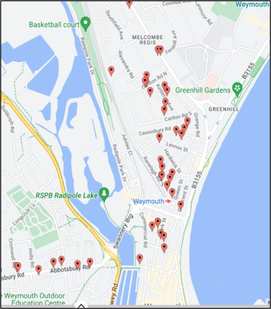
9.149 A house in multiple occupation (HMO) is a property rented out by at least three people who are not from one ‘household’ (for example a family) but share essential facilities like the bathroom and kitchen. It has recently been reported that there are 50 registered houses in multiple occupation in the neighbourhood area in addition to a considerable number which are not registered. Most of them are in Weymouth Town Centre or in the vicinity of it.
9.150 All single storey and two storey HMOs with five or more occupants are required to be licenced. Licensed HMOs must reach and maintain a required standard of quality and safety to retain their licence85. Restrictions also apply to the property owner in relation to passing a ‘fit and proper’ test. There are, however, many other properties that would be classified as an HMO, which are not licensed.
9.151 Local authorities can introduce an ‘Article 4 Direction’ which requires planning permission to be obtained for the change of use of single dwellings (Use Class C3) to HMOs, with three to six occupants (Use Class C4). Such applications should not be approved in parts of Weymouth which already have a high level of HMOs.
9.152 WNP have commissioned a housing needs assessment. It emphasises that HMOs contribute to satisfying a housing need. Some are occupied by those leaving or working away from home but the majority in Weymouth home those who have limited housing choice. HMOs contribute to tackling homelessness, empty properties, and residents that may have multiple complex needs. It cannot be doubted either that there are many problems associated with HMOs. There is clear evidence that an over-concentration of HMOs is having a detrimental impact on specific parts of the Town, especially within the Park District (DT4 7), and parts of both Westham North Ward (DT4 0) and the harbour area (DT4 8).
9.153 While HMOs are necessary to provide housing access to people on lower incomes there is evidence that too many HMOs, too close together, create too much stress on a neighbourhood. This was known in the 2017 when the Melcombe Board published its report86 identifying the causes and recommending solutions to the problems in Melcombe Regis. This stress is evidenced by the Index Of Multiple Deprivation 2019 with this area scoring in the worst 3% nationally. The Melcombe Board concluded that ‘the structural decline of seaside resort towns, low paid seasonal jobs and cheap, poorer quality housing has created a high transient population many with complex needs’. The report identified that there were 1050 private rented flats. Some of these are in registered HMOs which Dorset Council state have been improved in recent years. But many properties were below the level requiring supervision as HMOs housing 5 or more households.
9.154 More recently, in 2020 and 2021 during the COVID Crisis, most of Dorset’s Homeless were temporarily housed in two hotels in Melcombe Regis. This led to a wave of anti-social behaviour as the new residents mixed with the existing residents in nearby HMOs requiring police and ambulance attendance. This was eventually dealt with by increasing the level of police and PCSO patrols in the area and was solved when the residents were dispersed to other parts of Dorset.
9.155 Map 25 shows the concentration of HMOs in Weymouth. Policy W29 supports HMOs where the proposed development does not lead to an over-concentration in a specific area, but requires high standards of design, development, layout, and space to be achieved. Such developments must meet the required standards of Dorset Council and not harm the amenity and character of the neighbourhood in which they are located.
Policy W30: First Homes Exception Site Development
1. Development proposals for affordable housing schemes outside the DDBs, where housing would not normally be permitted by other policies in the development plan, will be supported if the scheme:-
i. is a First Homes exception site;
ii. is adjacent to an existing settlement and in character and scale appropriate to its location; and
iii. does not compromise the protection given to relevant areas by the NPPF.
2. Exception site housing schemes should normally comprise 100% affordable housing, intended only for local people including a minimum of 25% First Homes. A small proportion of market homes may be allowed on the site at the local authority’s discretion or if there is clear evidence of local need, or if this is required to make the site viable.
3. The application of a local occupancy clause on all affordable homes will be expected in perpetuity, without the requirement for further justification.
9.156 The defined development boundaries for the area have been purposely drawn precisely, in accordance with an agreed set of criteria, to protect our open areas, wildlife habitats and agricultural land. Those areas that are deemed most precious and most important are protected by policies in the Neighbourhood Plan. The Local Plan policy HOUS2 adequately sets out policy for exceptions to development constraints outside the DDBs in rural areas. This policy seeks to identify how the First Homes Exception Sites, introduced in the Ministerial Statement on 24th May 2021, shall apply in the Weymouth Neighbourhood Plan Area. Unlike Rural Exception Sites, First Homes Exception sites are not automatically limited to no more than 1ha.
9.157 Allowing development to take place outside of the DDB is a decision that should not be taken lightly. Policy W30 recognises however that the need to increase the stock and range of affordable dwellings that will be available for local households in perpetuity, may justify moderate-scale development beyond, but close to the DDB, on land whose value, in open space terms, is marginal, and in locations that can cope with or may even benefit from an increase in households and are within walking distance of facilities and community infrastructure.
9.158 Evidence and consultations have established that there is a substantial need for more affordable homes. For this reason, development proposals for ‘first home’, affordable housing schemes on land adjacent to the DDB will be considered. Such schemes should demonstrably satisfy a local affordable housing need in terms of size of dwellings and tenure mix in accordance with policy W30. It is expected that most homes will be available for social rent and allocated in accordance with the prevailing local housing allocations policies. Policy W30 requires affordable homes on exception site schemes to be secured in perpetuity.
9.159 Much of the land outside the DDB however is protected from development by other policies in the Neighbourhood Plan. This land will not be suitable for exception site residential development. Developers and their social housing partners should focus on sites that have no such protection and have been assessed as potentially suitable by the latest site development potential exercise that has been accepted by Dorset Council, the Local Planning Authority.
Policy W31: Principal Residence Requirements
This policy, supporting text and Map 26 have been removed from the Plan as a result of the Examiner’s recommendation.
Policy W32: Town Centre Car Parks
Redevelopment proposals relating to car parks in or adjacent to the Town Centre will not be supported unless the proposed development provides a comprehensive proposal addressing all the following criteria:
i. Adequate, convenient, safe and secure alternative off-road parking provision for all residents and businesses is shown to be available in appropriate locations;
ii. will be adequately catered for by solutions including other car parks and out-of-town ‘park & ride’ schemes;
iii. the provision of sufficient parking and servicing space for the operational requirements of the new development is provided within its curtilage or nearby;
iv. the development provides local employment and/or night time family leisure activities and/or homes that demonstrably satisfy a local demand; and
v. the proposed development would not result in an unacceptable impact on highway safety, or the residual cumulative impacts on the road network would be severe.
9.160 Town Centre car parking is a contentious issue as we seek ways to reduce traffic movements in the Town Centre, measures to reduce traffic congestion, pollution and improve road safety whilst supporting the needs of residents and local businesses.
9.161 There are seven sites within Weymouth Town Centre providing public car parking, which are owned by Dorset Council. These sites are often in prime and sensitive locations, such as adjacent to Radipole Lake and the Inner Harbour. All seven sites were listed in Dorset Council’s 2021 SHLAA87 as follows: The Swannery Car Park (921 spaces), Park Street Car Park (130 spaces), Melcombe Regis Car Park (272 spaces), The Loop Car Park, Harbourside Car Park (92 spaces), Commercial Road Car Park and Governors Lane Car Park (59 spaces). In addition, there are privately operated car parks including the multi-storey car park (470 spaces) on Commercial Road. Existing car parks are free from 6pm to 8am the next day. Permits are available for residents and businesses.
9.162 Planning permission has already been granted for the conversion of the Newton’s Road Car Park to residential. The North Quay Council Offices, and Peninsular sites include car parks, 63 and 326 spaces, and are subject to the Local Plan redevelopment policies WEY7 and WEY6 respectively.
9.163 The existing Local Plan states that the main visitor car park is The Swannery Car Park (921 spaces) with a secondary visitor car park at Lodmoor Country Park (564 spaces).
9.164 The latest Transport Strategy report88 was published in February 2019. This addresses car parking in Weymouth and uses 2015 and 2016 data from six of the Town Centre car parks. It found that weekday parking demand in Weymouth varied considerably through the year. There is a clear summer season peak in demand for car parking in Weymouth, with other spikes in demand being associated with other school holidays. In 2015, parking demand on winter weekdays peaked at around 500 vehicles whilst demand on summer Saturdays peaked at more than 2,000 vehicles. The day of highest parking demand occurred during the Dorset Seafood Festival, with around 2,500 parked vehicles at the time of peak accumulation.
9.165 Data further indicated that central car parks reached near capacity on many Saturdays and during holiday periods. This creates a perception of insufficient parking capacity. However, there are often considerable numbers of spaces available at the Swannery car park and Mount Pleasant park and ride. Use of these two car parks varied considerably through the year and provides the extra capacity required on days with higher parking demand.
9.166 This report made several recommendations including;
9.167 There is strong community support for the re-invigoration of the Mount Pleasant Park and Ride. This will help address the peak summer demand in Weymouth. This is addressed in policy W25.
9.168 There has been vocal opposition to the loss of any car parking in the Town Centre partly by residents no longer being able to park near their homes but also because of concerns about supporting local businesses in the Town Centre where their customers need to park in the Town Centre. There has also been support for developing one or two sites for affordable homes, leisure or employment or some combination. The 2015 data suggests that there is adequate resident parking except in the summer when spaces are occupied by visitors.
9.169 Policy W32 is supportive of proposals to make better alternative use of car parking areas in the vicinity of the Town Centre as long as redevelopment does not result in a net loss of car parking space that will markedly inconvenience Town Centre residents or disadvantage Town Centre businesses. As part of this equation, the capacity of existing car parks could be increased by introducing additional tiers or seeking other solutions such as out of town park and ride schemes.
9.170 Regarding demand, there is evidence from the 2021 census shows that around a third of Town Centre households do not have daily access to a motor vehicle. A much higher proportion than other parts of Weymouth, which range from 13.4% to 26.1% of households who are car-less. The level of non-ownership may increase and demand for car parking spaces in the Town Centre decrease as the Government’s Active Travel policy89 encourages a move away from permanent car ownership.
Policy W33: Timing of Infrastructure
Development should be phased so that it is at least in tandem with the timely and co-ordinated provision of associated infrastructure to help support sustainable growth, with particular emphasis on encouraging brownfield redevelopment and to ensure that the capacity of existing infrastructure is not significantly exceeded.
9.171 A common area of public feedback and concern has been about how the area’s infrastructure is going to cope. There are significant worries that education, health and wellbeing services, the transport network, safe walking and cycling routes and the sewage system will remain more than adequate to serve a growth in population as well as increased visitor levels and a changing demographic (& the impacts of climate change). For at least 10 years, for instance, the inadequate sewerage capacity in the Upper Wey Valley has resulted in pollution to the highways, specifically water flooding in Church Street and diluted raw sewage flooding in Watery Lane, and the River Wey. Local residents filed 12 formal complaints with Wessex Water in 2023 and a further 16 to date in 2024 detailing such flood events.
There are also regular ‘spills’ into coastal waters when heavy rainfall in Weymouth area results in discharges of untreated sewage (diluted with rainwater) from Wyke Regis treatment works.90 Rainwater discharges from roof areas and hard surfaces should be dispersed to “soakaways” and prevented from entering the combined sewerage system.91
9.172 The efficacy and capacity of the area’s flood defence infrastructure is of constant concern. It has recently been reviewed. Along with other aspects of the key infrastructure we are dependent on the responsible bodies and authorities responding positively to the growth and development consequentials and ensure that the area’s infrastructure is more than adequate, not only to serve the new development but also to improve current inadequacies.
9.173 It is recognised that major infrastructure lies beyond the remit of a neighbourhood plan, but it was felt that the Plan should at least reference these concerns and make it clear that we regard Local Plan policies COM1 and COM10 ‘Infrastructure’ to be very important. Local plans are required to plan positively for the development and make sufficient provision for the infrastructure required in the area to meet the objectives, principles, and policies of the NPPF (para. 22). Development should only be permitted where it is supported by appropriate infrastructure that is provided in a timely manner.
9.174 Development proposals should include a realistic assessment of their impact on the existing local infrastructure, services and facilities and demonstrate how any such impacts will be addressed so as not to disbenefit existing residents and businesses or harm the natural or physical environment.
9.175 The Planning Act 200892 introduced the Community Infrastructure Levy (CIL) as a means of enabling local communities some flexibility to choose what community and social infrastructure they also need to deliver their development plan. The CIL can be used to fund a very broad range of facilities such as play areas, parks and green spaces, cultural and sports facilities, district heating schemes, police stations and other community safety facilities.
9.176 Dorset Council became responsible for the CIL Charging Schedule from 1 January 2019. It is charged at a set amount per square metre of additional floor area and increases each year. Any qualifying development granted permission is liable to pay the levy. The levy must be spent on infrastructure projects. “When delivered through the CIL, such provision will be expected to take place as soon as reasonably practicable after the funds are collected”93.
9.177 Once the Neighbourhood Plan has been made, 25% of the levy will be paid directly to the Town Council, to be invested, at its discretion, in community infrastructure projects that should maximise community benefit and sustainability.
Policy W34: Sustainable Development
1. All new development should seek to achieve high standards of sustainability.
2. New development will be supported provided:
3. The retrofitting of energy conservation measures and renewable energy technology is supported. Where planning permission is required, measures and installations should be designed to minimise visual impact and nuisance to adjoining uses. The sensitive retrofitting of historic buildings and buildings in Conservation Areas should follow the guidance provided by Historic England.
9.178 Local Plan Policy ENV 12 ‘the Design and Positioning of Buildings’ encourages developers to achieve a high quality of sustainable and inclusive design. The policy states the development “will only be permitted where it complies with national technical standards”. It sets criteria to steer the design process to create a high quality and locationally sensitive development. Local Plan Policy ENV 13 ‘Achieving High Levels of Environmental Performance’ states an expectation that new buildings, alterations, and extensions to existing buildings will achieve high standards of environmental performance.
9.179 The installation of an appropriate SuDS system is critical given the growing flood risk in much of the area. Development proposals should demonstrate that the volume and rate of surface water run-off onto adjacent land and traffic routes is either at a lower or equal level to that prior to the development.
The NPPF (para 180) states that planning policies and decisions should ‘contribute to and enhance the natural and local environment by:
a) protecting and enhancing valued landscapes, sites of biodiversity or geological value and soils. Policy W37 seeks to enable soil conservation measures both during and after construction by requiring, as a minimum, the production of a Soil Survey and an associated Soil Management Plan94.
9.180 Since the Local Plan was adopted in 2015, interest and demand for ‘eco-friendly’ homes has multiplied, especially in the context of rising energy costs. The communities of Weymouth have shown through consultation a willingness to commit to carbon neutrality and a more sustainable way of living and working. The expectation is that all new development will be in harmony with that ambition. Just as other epochs are identifiable by the buildings of the time, the new buildings of Weymouth should be a conspicuous physical manifestation of how we chose to live in the first half of the 21st century.
9.181 Reducing pollution is an often repeated request at community consultations. Air pollution from road traffic is of great concern and highlighted by action being taken in the large cities. The pollution of our water courses is a constant threat. Light pollution may be an inevitability for a seaside town, but it can and should be reduced if we are to achieve our biodiversity goals.
9.182 Policy W34 should serve developers as a sustainability checklist. Proposals that exceed the current technical standards for sustainable construction and development are strongly encouraged.
9.183 The retrofitting of existing traditional buildings in the interest of reducing carbon emissions and greater energy efficiency is encouraged if the conservation needs are sufficiently acknowledged. There is a growing number of guides available to help developers. These, and the advice of the LPA, should be sought out, especially in the case of heritage buildings. Historic England have relevant websites95, and have produced a guide96 on fitting solar panels to historic buildings.
9.184 The policy will align with the relevant environmental targets and objectives as shown in the table below.
| Policy W34: Relevant Environmental Targets | |
|---|---|
| Objective 1: |
Carbon Neutrality Targets 1-8 inclusive |
| Objective 2: |
Resource Efficiency Targets 9-21 inclusive |
| Objective 3: |
Biodiversity Net Gain Targets 22-25 inclusive |
| Objective 4: |
Climate Change Management Targets 26-31 inclusive |
58 Area profile for Weymouth - Dorset Council
60 Weymouth Neighbourhood Plan: HNA - April 2021
61 Dorset & BCP Local Housing Needs Assessment
62 Weymouth Neighbourhood Plan HNA - November 2024
63 Weymouth NP HNA - November 2024
64 Weymouth Neighbourhood Plan - Affordable Homes Paper
65 Weymouth Neighbourhood Plan Site Options & Assessment Report - January 2023
66 Weymouth-Neighbourhood Plan -Viability-Report – November-2024
67 UK Parliament - Ministerial Statement on Affordable Homes Update - May 2021
68 Historic England - Energy Efficiency & Retrofit in Historic Buildings - July 2024
69 Gov.UK - Planning Obiligations - Use of planning obligations & process for changing obligations
70 WTC - Councillors pledge to make Weymouth a great place for walking
71 Weymouth NP HNA - November 2024
72 "Footnote: “A lower level of provision will only be permitted if there are good reasons to bring the development forward and the assessment shows that it is not economically viable to make the minimum level of provision being sought.”
73 Weymouth Neighbourhood Plan - Site Assessment Final Report - Jan 2023 Footnote: Social
74 Footnote: Social rent is usually paid to registered providers and local authorities. It is low cost rent that is set by a government formula.
75 Purbeck Local Plan (2018 - 2034) Adopted 2024
76 WNP - 3rd Community Engagement Report
77 WNP - 4th Community Engagement Feedback
78 WNP SEA Report - October 2023
79 Bailey Venning Report - November 2023
80 Viability Report November 2024
81 Bailey Venning Assoc Report - November 2024
82 CoHousing UK - Bridport CoHousing Project
83 We can Make - Test Space in Bristol
84 Weymouth HNA - November 2024
85 Dorset Council - Houses of Multiple Occupation
86 Dorset Council - Melcombe Regis Strategic Plan 2017
87 Dorset Council - Strategic housing and economic land availability assessment
88 Dorset County Council - Weymouth Town Centre Transport Strategy
89 Active Travel England: Corporate Plan 2023 to 2025
90 Coast and rivers watch map | Wessex Water
91 CSO-Insights-Paper - July 2023 Final.pdf
92 Legislation: Changes to Planning Act 2008
93 Dorset Council WDW&P Local Plan 2015
94 Soils-in-Planning-and-Construction-Sept-22.pdf
< Previous | ^ Top | Next >