
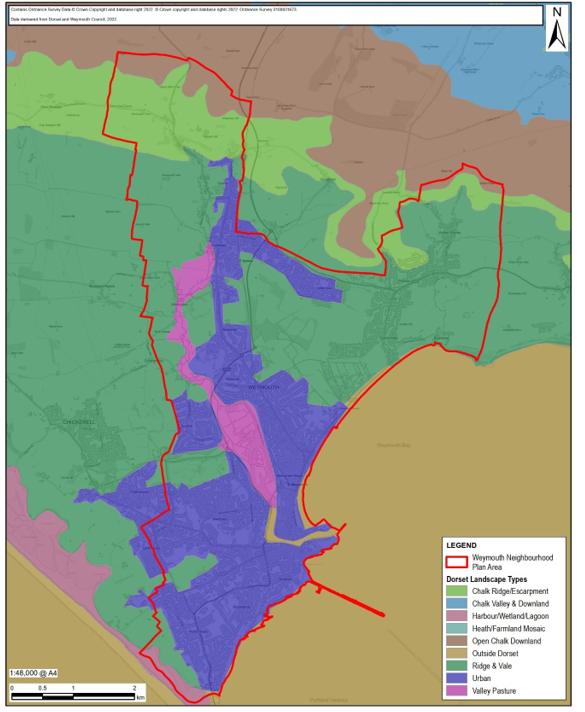
8.1 The neighbourhood area covered by the Weymouth Neighbourhood Plan has many areas of countryside and greenspace. Map 4 demonstrates just how much of the area has a defined landscape character that is not urban.
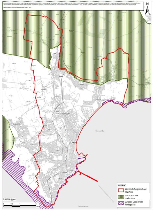
8.2 Within the landscape character area there are extensive tracts of SSSI’s33 and local nature reserves (see Map 6), many of which contain important water-based habitats. Much of the coastline is part of the Jurassic Coast, a World Heritage Site. Additionally, the chalk streams of the River Wey and River Jordan are of great habitat importance.
8.3 It is one of the purposes of the Neighbourhood Plan to protect and enhance our unique distinctive environments, including landscapes and coastline.
8.4 The Dorset National Landscapes (DNL) includes those parts of the neighbourhood area northwest of Upwey and around Sutton Poyntz (see Map 5). The Neighbourhood Plan provides an opportunity to embed DNL Management Plan34 land-use objectives and policies in the extant and evolving Local Plans.
8.5 Open greenspace is very important to the sense of health and wellbeing experienced by the people of the area. 64% of respondents to the 2022 Community Survey35 expressed high regard for the area’s countryside and parks.
8.6 The area is blessed with 91 hectares of publicly accessible green space, which not only provides for the daily recreation needs of the permanent residents of Weymouth but also offers leisure and recreation opportunities to the town’s many visitors. Weymouth’s gardens and play areas are the most frequently used leisure facilities in the town. From play areas and skate parks to tennis courts and tranquil walks, there is something for everyone. Each year the gardens play host to several events, including smaller scale community fairs and open-air musical concerts.
8.7 Weymouth Town Council manages nine public parks and gardens. Five of these have Friends Groups who organise events to promote the parks. Two of the parks have received Green Flag awards. These spaces provide natural beauty in the town and also support leisure and physical activities for all ages. In the 2022 Community Survey, 55% expressed satisfaction with the parks and gardens as they are, illustrating that people care but there is opportunity for improvement.
8.8 Areas of woodland are few and small, for example in the Lorton Valley, at Redlands and along the Rodwell Trail. The only area of designated ‘Ancient Woodland’ is at Two Mile Coppice.
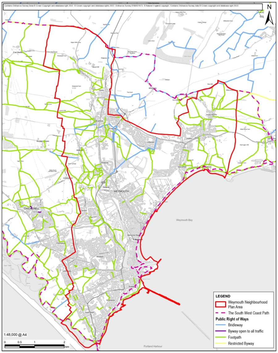
8.9 The network of public rights of way is an important facet of the open space offer and provides connections and corridors between open spaces. The area includes many miles of public rights of way, including a section of the South West Coast Path and numerous bridleways that provide links between settlement areas and access to the countryside. There are several important trails such as the Wey Valley Riverside Walks, the Rodwell Trail and the Jubilee Trail, passing through Upwey. Grass and gravel routes may be added in a similar way to those at the Moors Valley Country Park and Forest to facilitate joint walkway and responsible off-road cycling access.
Map 4: Landscape TypesW05
8.10 The farmland of the neighbourhood area is largely treeless with small pockets of woodland. The open fields on the slopes are divided by sparse hedgerows, post and wire fencing and occasional dry-stone walls. The soil is relatively thin and much of it is classed as Grade 3 agricultural land. It may not be the most productive farmland, but it is important for the character and setting it provides and the opportunity for local people to connect easily with the countryside.
8.11 The area’s greenspaces play a significant role in flood alleviation. Many are low-lying and prone to flooding. The main sources of flood risk to Weymouth Town Centre are water tide levels in the harbour and waves topping over the Esplanade. High tidal levels also exacerbate flooding upstream of Westham Bridge. The River Wey floods if high tide coincides with prolonged heavy rainfall. Another risk arises from silt deposition in Radipole lake. At high tide, the nature reserve is tide locked and acts as the flood defence, however as the lake continues to silt up the capacity to store water will decrease.
8.12 The Wey Valley villages of Upwey, Broadwey, Nottington, and Radipole are all prone to surface water flooding which can be exacerbated by high tides. In the Upper Wey Valley groundwater flooding is also a frequent occurrence. In general flood patterns follow the River Wey and the River Jordan which flows through Sutton Poyntz and Preston to Bowleaze Cove. The Environment Agency has introduced flood mitigation areas in the Wey Valley and taken action to mitigate flooding on the River Jordan in Preston. In both areas, groundwater flooding is a frequent occurrence during periods of high rainfall due to overflow of the storm water drains.
Map 5: Dorset National Landscape and Jurassic Coast World Heritage Site
Our Neighbourhood Plan Policies and their Explanation / Justification
Policy W01: Shoreline Protection
Development proposals, specifically to prevent coastal erosion or flooding, and protect property and businesses, in areas designated by the South Devon and Dorset Shoreline Management Plan to be protected will be supported.
8.13 Taking account of coastal change resulting from natural forces and climate change is consistent with the NPPF. However, para. 177 of the NPPF requires plans to avoid inappropriate development in vulnerable areas, whilst not exacerbating the impacts of physical changes to the coast.
8.14 The South Devon and Dorset Shoreline Management Plan (SMP)36 sets out what is agreed to be the most sustainable approach to managing the flood and coastal erosion risks to the coastline over the next 20, 50 and 100 years. Within this approach it identifies stretches of coastline where the policy is ‘hold the line’. It is a policy document for the planning of sustainable coastal management. It takes account of other existing planning initiatives and legislative requirements and is intended to inform wider strategic planning.
8.15 Redcliff Point to Portland Bill is recognised by the SMP “as one of the more heavily developed stretches of coastline within the SMP area, incorporating the key service and tourism centre of Weymouth and the Isle of Portland. The area also has several nature designations for both geological and biological reasons. This whole stretch of coast is heavily dependent on any changes to the breakwaters. Policies developed in this area have assumed that the breakwaters will remain and be maintained. A key driver of policy in this area is the continued protection of commercial and social assets, which requires the continued defence of the shoreline for much of this area. This will, however, result in coastal squeeze of intertidal habitats against fixed sea defences. At Bowleaze Cove and Preston Beach, the long-term vision is to provide more sustainable defences through realignment of existing defences”.
8.16 Weymouth already floods and is impacted by coastal erosion. “With a robust prediction of an acceleration in sea level rise and more intense weather events because of climate change, the problems facing Weymouth will increase significantly. In October 2020, Dorset Council approved the Weymouth Harbour and Esplanade Flood and Coastal Risk Management Strategy which drew upon all relevant reports, bringing together their findings and recommendations to define a preferred strategic pathway to managing coastal flooding and erosion risk around Weymouth Harbour and along the Weymouth Esplanade and put in place measures which protect Weymouth to at least the same level as is current.”37 In February 2024 Dorset Council published the Level 2 Strategic Flood Risk Report38 for Weymouth Town Centre. This updates the previous assessment and details the changes to Flood Zones in Weymouth Town Centre.
8.17 Policy W01 supports development necessary to prevent coastal erosion or flooding if it is consistent with the ‘hold-the-line’ approach of the SMP and any approved coastal management strategy.
Policy W02: Conservation of the Natural Environment
1. Areas of benefit to nature and geological conservation, such as country parks, nature parks and reserves must be retained and protected from detrimental negative impacts likely to arise from development39 .
2. Any development brought forward must ensure that it can be implemented without adverse effect upon the integrity of the Habitats sites. Proposals that will adversely affect the integrity of Habitats will not be supported.
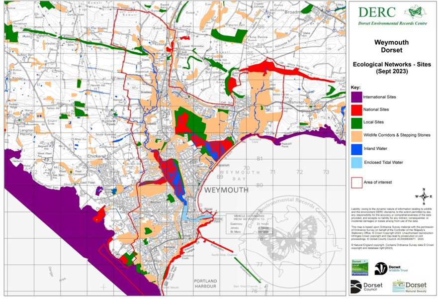
8.18 The neighbourhood area is fortunate to have several areas of nature or geological conservation designated as being of International, National or Local importance - see Map 6. Many are managed with public access in mind. The following nature conservation areas have all been the subject of measures to protect and enhance the diversity habitats and wildlife inhabitants.
The geological sites of interest are:-
Each has its own special characteristics; each has had to find ways to accommodate regular visitors and tourists who are attracted to them.
8.19 Policy WEY16 of the Local Plan allocates land between Preston Beach Road and Southdown Ridge, to extend Lorton Valley Nature Park “to promote sustainable tourism, management of conservation and heritage interest, enhancement of public access and open spaces and opportunities for volunteer and community involvement”. The Nature Park not only protects important habitats and helps to maintain the area’s biodiversity it serves as an education resource and a destination for trail walkers and other visitors. Local Plan Policy WEY8 is permissive of new tourism and recreation facilities at Lodmoor Country Park as long as they do not harm the character or natural environment.
8.20 Policy W02 not only protects existing designated areas which benefit nature or geological conservation, it also supports the recognition of other areas where the purpose of protecting an important natural environment is clear and where enhancements will not only help safeguard the special character of the site from a habitat perspective, they can provide for an increase in responsible public access to appreciate nature.
8.21 Policy W02 supports all measures to enhance the resilience of all the protected sites and to gain and maintain a favourable condition for all SSSI sites in accordance with UK government's 25 year environmental plan, 2018.
Map 6: Network of Ecological Sites and Wildlife Corridors
Policy W03: Wildlife Habitats and Areas
1. Development proposals that are likely to have a significant adverse effect on the integrity of habitats of local and national importance and the wild flora and fauna in those areas that form part of the ecological network will not be supported unless unavoidable due to exceptional circumstances and the proposed mitigation measures are proportionate to the status of the site and satisfy the requirements of the local planning authority.
2. Where impacts to biodiversity are identified, proposals must apply the mitigation hierarchy as advised in the NPPF. Compensation measures will be permissible as a last resort only.
3. Proposals to protect or restore any existing features, or to create new features of wildlife habitat, particularly where these form linkages between habitats within or beyond the site, will be encouraged and supported.
8.22 The Weymouth area has the benefit of a rich and diverse landscape with a varied and valued biodiversity. Part of the neighbourhood area is within the formally designated Dorset National Landscape. Whilst it is recognised that development will be required in the future in accordance with the overall aims and objectives in this Plan, it is essential that such development takes place based upon a detailed knowledge of the ecological status of a defined site and location and the incorporation of appropriate and proportionate mitigatory measures, with the greatest weight being given to avoidance, and the use of compensation being a last resort. In this way the adverse impact of development on biodiversity, habitats and species can be prevented; and opportunities taken to enhance biodiversity, whilst allowing well designed sympathetic development to proceed.
8.23 Policy W03 complements policy ENV2 of the Local Plan by ensuring that development does not adversely impact those locations in the Weymouth area that are recognised by the Dorset Environmental Records Centre (DERC) as having significant ecological value.
8.24 The NPPF para. 182 makes clear that great weight should be given to “conserving and enhancing landscape and scenic beauty in Areas of Outstanding Natural Beauty which have the highest status of protection”. Regarding recognised wildlife areas, “plans should distinguish between the hierarchy of international, national and locally designated sites; allocate land with the least environmental or amenity value, where consistent with other policies in this framework; take a strategic approach to maintaining and enhancing networks of habitats and green infrastructure; and plan for the enhancement of natural capital at a catchment or landscape scale across local authority boundaries” NPPF (para. 181).
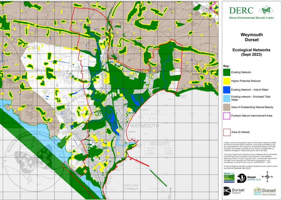
8.25 DERC has prepared a biodiversity-rating of the area’s natural habitats in ascending order of biodiversity sensitivity. Map 6 shows those higher-rated locations in the Weymouth area that are of: outstanding habitat and designated internationally, nationally; locally important sites (areas of good natural/semi-natural habitat); along with wildlife corridors (other semi-natural habitats of predominantly native species). Those areas regarded by DERC as ‘high potential areas’ for biodiversity gain because of their relation to factors such as adjacent areas, connectivity or projected value as stepping stones, buffer zones, etc are shaded yellow on Map 8.
8.26 The areas gardens, allotments, and amenity grassland, which can also be ecologically significant are generally outside the scope of policy W03 and addressed by other policies in the development plan.
8.27 Development proposals that are likely to impact on areas shown on Map 6 or as wildlife corridors and ‘High Potential Areas’ for biodiversity gain on Map 8, will need to be supported by a full site specific independent ecological habitat and species assessment and production of a site-specific biodiversity action plan that provides for protection, conservation, and enhancement of biodiversity. Development impacting national and locally important sites will only be supported in the most exceptional and unavoidable circumstances, and where the public benefit would clearly outweigh the loss or deterioration of habitat. For other sites Local Plan policy ENV02 should apply, and the local planning authority’s hierarchy of mitigation adhered to.
8.28 “Use of the mitigation hierarchy is fundamental to Dorset Council’s approach to protecting biodiversity as detailed in the Dorset Biodiversity Appraisal Protocol40. The hierarchy aligns with the NPPF and is stated - If significant harm to biodiversity resulting from a development cannot be avoided (through locating on an alternative site with less harmful impacts), adequately mitigated, or, as a last resort, compensated for, then planning permission should be refused.” (Paragraph 186 (a)). Whilst policy W03 recognises the hierarchy of mitigation in the Local Plan, this should only be accepted as a last resort when all other options have been investigated and proven to be impractical.
8.29 Policy W03 recognises the critical importance of connectivity to wildlife. The ecological networks are a valuable resource towards constructing a Habitat Recovery Network for Dorset. Connectivity is key to building such a network and Weymouth has much to offer by linking designated and non-designated areas of wildlife importance through wildlife corridors41. Such connectivity should recognise adjoining wildlife corridors and seek to bridge ‘gaps’ in transit routes for example through the natural extension of the Chickerell Wildlife Corridor by recognition of the land south of Wessex roundabout as a wildlife link to Radipole and the Lorton Valley. Further links within the area are also possible by utilising the natural features of the river valleys such as by extending the Sutton Poyntz Wildlife corridor along the River Jordan to Bowleaze Cove and incorporating the Wey Valley Water Meadows into the River Wey corridor.
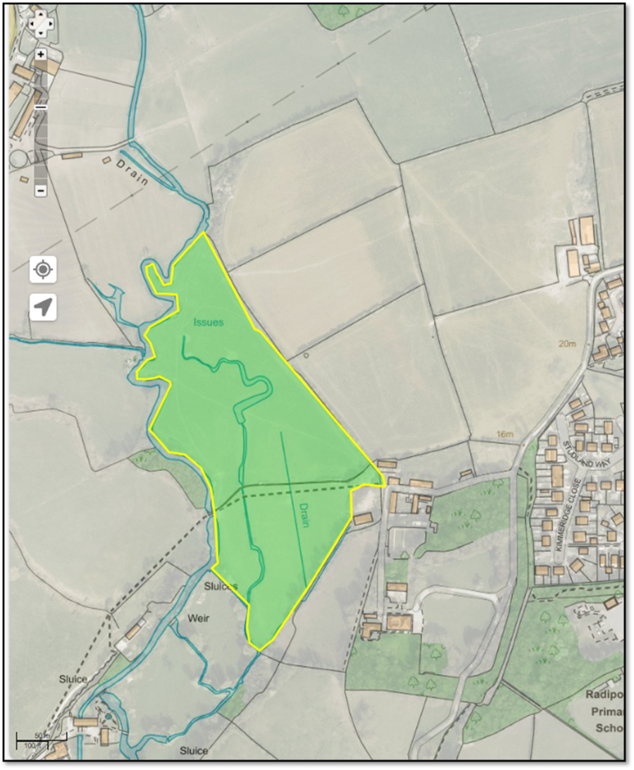
8.30 The Wey Valley Watermeadows comprise approximately 5ha of land beside the River Wey (see Map 7). They are essentially two fields with public access that have long been used on an informal, and generally responsible, basis by walkers, dog walkers, and horse riders, who take advantage of the local rights of way. The area is also known for its wildlife value and attracts naturalists on a regular basis.
8.31 The area features in the River Wey Walks promoted by the River Wey Society and provides one of the few walking areas beside the river where the path is not bounded by fences. Community consultation has affirmed the high regard that local people have for the area in question.
8.32 The DERC ecological maps provide a consistent framework to assist prospective developers of a specific site to make an initial assessment of the ecological status of that site and based upon validated research develop appropriate and proportionate mitigatory measures as part of a biodiversity action plan. Reference by developers to DERC regarding the sites identified on Maps 6, 7 and 8, will better facilitate the recognition and evaluation of connectivity within and between sites of ecological importance (including ‘High Potential Areas’) when formulating development proposals for a specific site and avoiding negative impacts on both that and nearby sites.
8.33 It is the intention that the DERC maps will be regularly updated based upon field study and feedback from public and specialist organisations and become a permanent part of the existing Dorset Ecological Networks maps. The data, being subject to validation, will provide a reliable and current source of ecological status of potential sites.
Map 7: Wey Valley Watermeadows
Map 8: Ecological Networks – Existing and Higher Potential
Policy W04: Wildlife Corridors
8.34 Whilst the neighbourhood area appears predominantly urban, it includes many significant wildlife areas and habitats. In 2010 it was acknowledged42 that these were relatively isolated from each other and from the wider countryside by urban development. Since that time much attention has been paid to identifying, protecting, and enhancing the areas wildlife corridors and stepping stone habitats in the interests of maintaining biodiversity and maintaining the migratory bird routes. In 2020 a follow-up study43 showed improvements in some areas and noted some losses because of development.
8.35 Map 6 shows the recognised wildlife corridors of the neighbourhood area in relation to designated sites. These are protected from inappropriate development. Any development that does take place within these areas should be justified on the basis of necessity and generally satisfying the requirements of the Dorset Biodiversity Appraisal Protocol (DBAP)44. The DBAP applies to all development sites of 0.1ha or greater in size, or where there are known protected species or important habitats/habitat features. It applies a mitigation hierarchy of avoid, mitigate, compensate in line with the NPPF.
8.36 Development that takes place within, or has an impact on, the Landscape and Wildlife Corridors should minimise damage and disruption and take every opportunity to enhance and/or extend the network of Landscape and Wildlife Corridors (as identified in Map 6). In accordance with the Environment Act (2021), all DBAP applications are required to provide a measurable biodiversity net gain of at least 10%. This policy recognises the value of directing Biodiversity Net Gain to enhance the broad habitat within the wildlife corridors and their inter and intra connectivity due to the proximity to developed areas.
BNG units delivered closer to a development site should be calculated at a higher value in the statutory biodiversity metric than those delivered further away so as to incentivise BNG within the wildlife corridors.
Policy W05: Ecological Impact of Development
1. Development proposals should comply with national legislation and the requirements of the Local Planning Authority and, unless statutorily exempt, must contribute to the enhancement of the natural environment by providing for Biodiversity Net Gain of at least 10% with a target of at least 20% judged on a case-by-case basis.
2. All development proposals should consider potential ecological impacts at an early stage in their design consistent with best practice guidance and identify an array of suitable habitats and other measures (e.g. bat tiles, swift bricks, bird boxes, retention of hedges and other heritage boundaries, green roofs, rainwater gardens etc) to be included in the development.
8.37 The NPPF para. 186 says that “opportunities to improve biodiversity in and around developments should be integrated as part of their design, especially where this can secure measurable net gains for biodiversity or enhance public access to nature where this is appropriate”.
8.38 Local Plan Policy ENV 8. requires developers to take “opportunities to incorporate and enhance biodiversity in and around developments will be encouraged”. It is expected that the new Local Plan will be much firmer in its biodiversity requirements. It will compel developers to deliver a minimum net gain in biodiversity through the restoration and re-creation of habitats and provide for the long-term monitoring and management of biodiversity features.
8.39 The relevant policy in the new Local Plan will be informed by the Environment Act 2021 under which all planning permissions granted in England (with a few exemptions45) will have to deliver at least 10% biodiversity net gain. Biodiversity net gain (BNG) delivers measurable improvements for biodiversity by creating or enhancing habitats in association with development. BNG can be achieved on-site, off-site or through a combination of on-site and off-site measures. BNG will be measured using Defra’s biodiversity metric and habitats will need to be secured for at least 30 years.
8.40 The policy calls for a minimum 10% Biodiversity Net Gain (BNG) with a target of a minimum of 20% BNG to be judged on a case-by-case basis in alignment with the Supporting Environmental Targets (Objective 3 Target 22) in Appendix A of this document. This is particularly relevant in those areas in close proximity to designated sites of wildlife importance and wildlife corridors. The higher figure aligns with feedback from the Environment Agency in response to the Dorset Council Local Plan consultation46 and is deemed viable on the basis of the Guildford report47. The higher figure also recognises the impact that residential development will have on nearby wildlife sites from an increase in recreational pressure in the local area.
8.41 Policy W05 requires development proposals to demonstrate that the possible ecological impacts have been considered and measured as part of the design process and, in accordance with guidance available from the local planning authority, several measures have been integrated into the development to achieve the required biodiversity gains. This policy requires development proposals to assess the impact on both wildlife habitat and species.
Policy W06: Trees, Woodlands, and Hedgerows
1. Development proposals should avoid the loss of or damage to trees, woodland, orchards, or hedgerows that contribute positively to the character, biodiversity, and amenity of an area.
2. Where loss or damage to trees, woodland, orchards, or hedgerows is unavoidable, development proposals must provide for appropriate replacement planting on the site with an indigenous species along with a method statement for the ongoing care and maintenance of that planting. The planting of new trees and hedgerows on the same basis will be supported.
3. Replacement planting should at least be on a two-for-one basis, adopt a ‘right tree right place’ approach and demonstrably increase the canopy cover on site consistent with an overall objective of a minimum 15% canopy cover over the plan period.
8.42 Areas of woodland within the neighbourhood area are generally small, for example in the Lorton Valley, at Redlands and along the Rodwell Trail. The only known area of designated Ancient Woodland is at Two Mile Coppice. Trees are essential infrastructure to support public health and climate resilience. Their current status is assessed by a tree equity score. Approximately 12% of the assessed Weymouth areas have the priority of give categories for increased canopy cover with a further 32% in the next category, a high priority.48 This policy requires development proposals to assess the impact on both wildlife habitat and species.
8.43 It is therefore important that where trees are lost for whatever reason they are replaced with an appropriate species, at a ratio greater than one-for-one. Weymouth Town Council is committed to planting 1,000 trees by 2025 as part of its Parks & Open Spaces Policy49. There are also a few traditional orchard sites that satisfy the definition50 of a priority habitat as well as several recently planted ‘community orchards’. Weymouth has an estimated tree canopy cover of 9.8%51. An overall objective of 15% is considered reasonable over the plan period and is consistent with the Weymouth Town Council Tree Management Plan 2021-2026. Development proposals that include tree replacement should indicate how the canopy cover will be increased.
8.44 Areas of established trees, particularly veteran trees, and traditional orchards, need to be protected from further loss to land development if the character of the area landscape is not to be further eroded. Information on the status of trees in the Weymouth area is available from Dorset Council52.
8.45 Established hedgerows too are an important feature of the landscape as historical boundaries, for their amenity value and are a priority biodiversity habitat. The loss of historical boundary hedges and dry-stone walls on agricultural land is seen as detrimental to conservation of the landscape. Agricultural hedges have some protection from the Hedgerows Regulations 1997.
8.46 It is important that new developments carefully consider the selection of species if biodiversity gain is to be maximised. Wildflower and grass seed mix should be selected to result in a food source across the growing season and consist mainly of perennial plants with addition of seeds that provide the appropriate food plant for invertebrate species present.
8.47 Trees and shrubs should be selected according to the site, specific location and to benefit a wide range of species of wildlife. Situations where native trees and shrubs can be mixed, such as in hedgerows, are ideal for plantings in new developments. They could also be planted in small copses or woodland or included in the gardens of homes and offices. For smaller properties, single small trees or shrubs could be planted and intermixed with typical low-maintenance planting.
8.48 It is important to consult relevant organisations such as Butterfly Conservation, Dorset Wildlife Trust and the Woodland Trust who will be able to provide sound advice on suitable species of wildflower, trees and shrubs.
Policy W07: Rights of Way and Access to the Countryside
8.49 The NPPF (para. 104) says “planning policies should protect and enhance public rights of way and access” and through the planning policies we should encourage improved public access to the Countryside (NPPF para 124). Whilst the PPG53 recognises that “public rights of way form an important component of sustainable transport links and should be protected or enhanced”.
8.50 The network of footpaths, bridleways and the South West Coast Path is shown on Map 9 Public Rights of Ways. Several have been promoted in local guides such as the Rodwell Trail and the series of Littlemoor walking maps and information, which aid local people and visitors alike to appreciate the ecology and heritage adjacent to the paths. Weymouth Town Council will continue to promote the value of the footpaths to community wellbeing.
8.51 Improvements to the footpath network of the area are consistent with the Ramblers Charter54 that was adopted by the Town Council in 2019. We are committed to ensure that everyone has access to high-quality green space within five minutes’ walk of their doorstep, a network of green walking routes connect people to the places they want to go, and green routes and spaces are designed with communities and open to all.
8.52 Policy W07 supports improvements and enhancements to the areas footpath network in the interest of responsible access and improving accessibility. It is important that any changes should be done in a way that cause least harm to local ecology and includes measures that will help enhance biodiversity.
8.53 New development should ensure that rights of way are incorporated into the layout whenever possible. Any diversion deemed necessary and acceptable to the local planning authority should demonstrate benefits for the natural environment and the users of the route.
8.54 Policy W07 also encourages the provision of dedicated easy walking routes through new developments that link to the wider green walking network, thereby provide safe and accessible motor-vehicle-free routes from urban areas into the countryside and to local services and facilities.
Map 9: Public Rights of Way
Policy W08: Coastal Green Recreation Areas
Coastal recreation areas shown on Map 10 are for public recreation and enjoyment and are protected from development unless it is for:
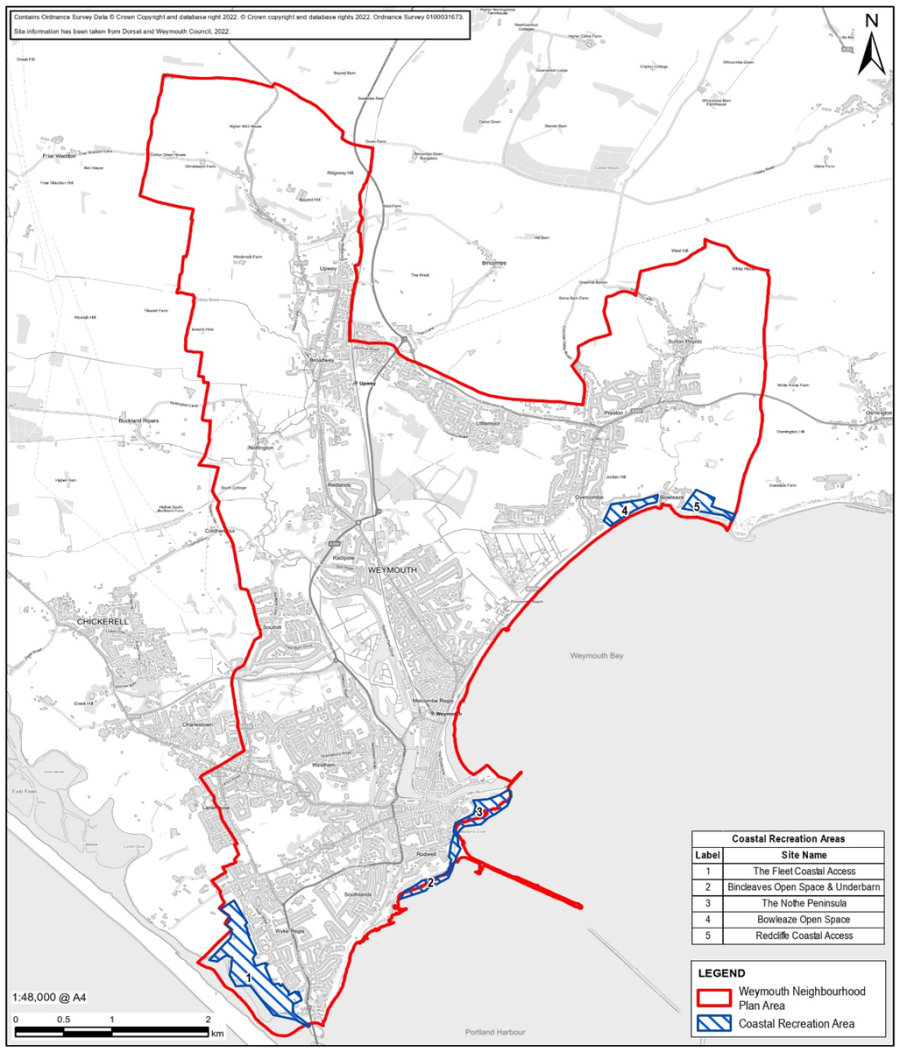
8.55 Map 10 shows the very important coastal green recreation areas that Weymouth is famous for, and which contribute so much to the wellbeing of residents and the enjoyment of visitors. These areas provide access to the public to coastal spaces providing natural recreation and views across the bay.
8.56 Several parts of the undeveloped coastal strip are protected by statutory designations, most notably The Fleet Coastal Area. Several other areas, in total or part, see Maps 11A & 11B (Bincleaves Open Space, Nothe Peninsula, Bowleaze Cove Open Space) are also proposed for Local Green Space Designation under policy W11 in this Plan. This policy however seeks to recognise those areas that are specifically coastal and where the prime purpose is not to protect and “fossilise” them but to control and constrain their development so as to avoid detrimental impact on future recreational public access and enjoyment. This policy specifically extends the right to safe and responsible recreational public access to these areas and the inter-connecting rights of way which is not provided for by Local Green Space Designation.
8.57 Policy W08 places protection, from most kinds of development, on those other predominantly green areas, which are primarily used for outdoor recreation purposes.
8.58 Policy W08 recognises that the following coastal locations have a special appeal, and each has its own unique character and setting, that should be safeguarded for public access and enjoyment. Their appeal is self-evident. The policy is intended to future-proof the value and appeal of these locations by being permissive of certain small-scale developments that serve public needs.
Designated Coastal Recreation Areas:
8.59 Bincleaves Open Space: This is an important coastal grassland area with scenic views over Portland Harbour, which is well used by all age groups for walking, dog walking and relaxation. It is a significant part of a well-used green corridor for walkers between south and central Weymouth.
8.60 Nothe Peninsula: This landmark area is well known for its panoramic coastline views of Weymouth Bay and Portland Harbour. It is a tranquil area that is appreciated and well used by visitors and locals alike. A range of trees, established shrub beds and winding paths lead down to sheltered slopes and picnic spots that serve walkers, sun bathers and families. The large, grassed area is used for ball games while, at the foot of the gardens, the seashore is a fun place for children to go crabbing in the rock pools.
8.61 Bowleaze Open Space: This coastal stretch of amenity grassland with a café offers beautiful scenic views of the coastline. It has high recreational value, both for local people and visitors to the area. It is part of a green corridor through east Weymouth and falls within the ecological network with significant wildlife value. It is well used and appreciated by coastal trail walkers, dog walkers, picnickers and those that simply want to appreciate the beautiful view.
8.62 Bincleaves Open Space and Underbarn: This stretch links The Nothe Peninsular with the Rodwell Trail. The Bincleaves Open Space has high recreational value, both for local people and visitors to the area with views across Portland Harbour and Weymouth Bay. The Thomas Fowell-Buxton memorial is a significant local landmark. The area includes the Coastal Look-out Station and gun-emplacement markers. Sections of the Underbarn remain open, whilst there are sections which are temporarily closed. Once safety issues are addressed re-opening the underbarn will increase the use of the space and enable the Coastal Path to be re-routed along the coast.
8.63 The Fleet Coastal Access Area – The King Charles III Coastal Path runs beside the Fleet, but the area of open space provides access to Pirate Cove and views across the Fleet. The area extends beyond the Weymouth Neighbourhood Plan Area.
8.64 Redcliffe Coastal Access Area – The English coastal path runs through this area and there are links to the nearby caravan sites and Preston village. The landslip area visible from the area is a unique habitat with deer and varied birdlife. The views across Weymouth Bay and along the coast to Weymouth are stunning. The area is much frequented by residents and visitors for exercise, tranquillity and relaxation.
Map 10: Coastal Green Recreation Areas
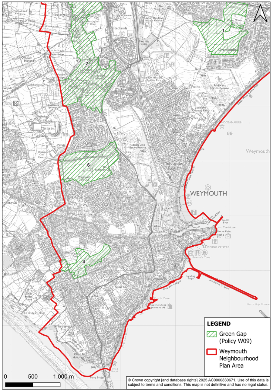
Policy W09: Green Gaps
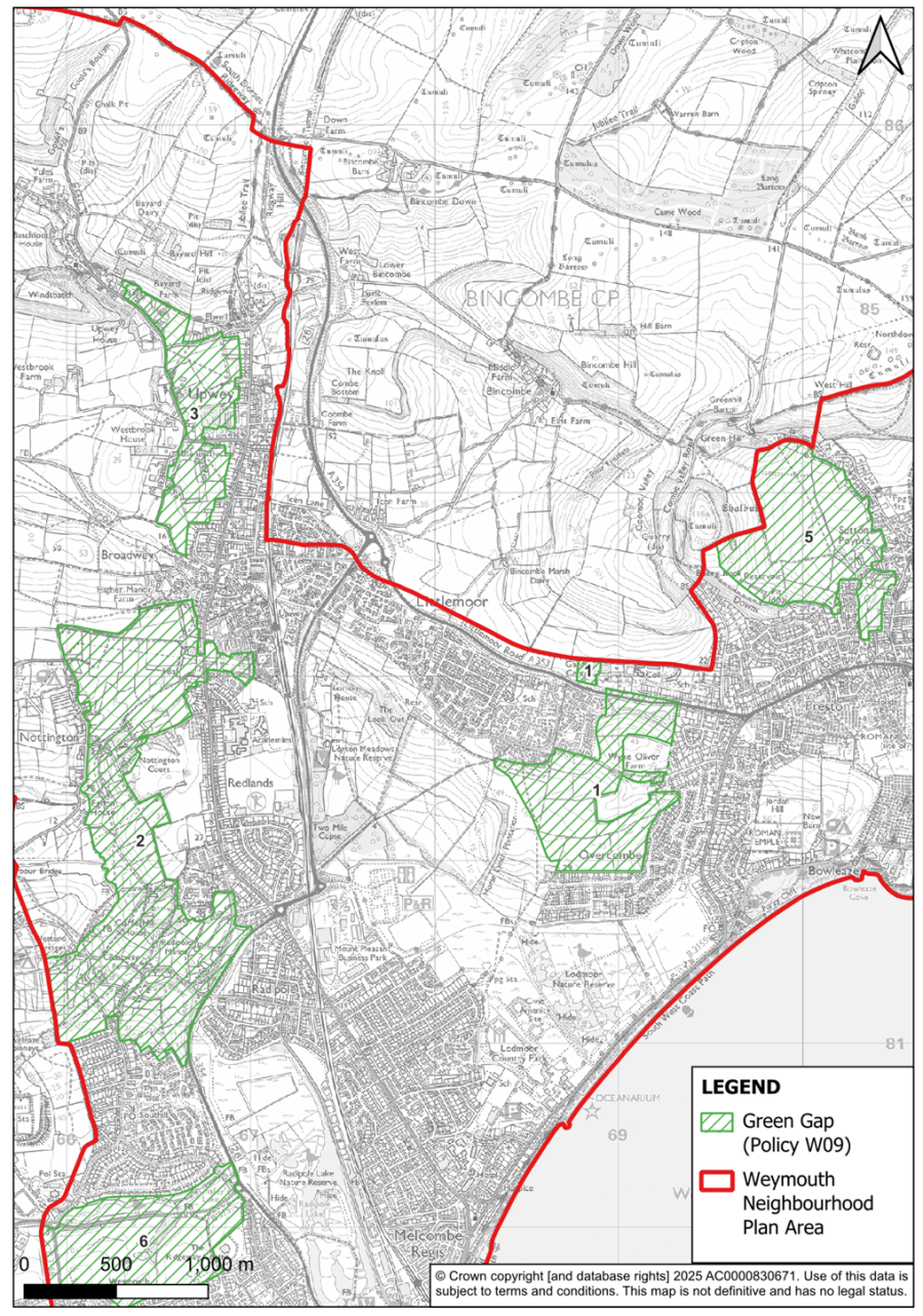
8.65 The Neighbourhood Plan has emphasised the importance of the local countryside and the natural environment within the neighbourhood area. To safeguard what we have, there is a need to keep the sprawl of settlement areas to a minimum. The Local Plan defines development boundaries, and these are endorsed by the Neighbourhood Plan (see policy W14). Policy W09 is intended to reinforce this approach with a specific policy that seeks to maintain a buffer or ‘local green gap’ between settlement areas, specifically to prevent coalescence.
8.66 The principle of a buffer to prevent coalescence or urban sprawl and protect the integrity of the settlements “that have distinct and separate characters from merging into one another”, is accepted by the Local Plan under Policy ENV3 ‘Green Infrastructure Network’. This policy, inherited from the West Dorset Weymouth and Portland Local Plan 2015, has been applied to those “important open gaps (as identified in the previously adopted local plan for Weymouth and Portland)” see Map 11A and Map 11B. The Local Plan also commits the LPA to “work together with local communities, developers and other relevant partners, such as town and parish councils, to develop a green infrastructure strategy for the plan area”.
8.67 In preparing the Neighbourhood Plan a review was undertaken of the ‘Important Open Gaps’ policy and the areas recognised by the 2015 version of the Local Plan. The 2023 community survey confirmed that considerable public support remained for the gap policy in providing buffer zones against coalescence in order that neighbourhoods are able to retain their individual character and identity. Only 3% of survey respondents were opposed to this idea or its application. In response to this endorsement areas to be recognised as ‘green gaps’ for the duration of the Plan period and serve as neighbourhood buffers are shown on Map 11A & Map 11B and the importance of their function is described in 8.68.
8.68 The importance and purpose of the ‘green gaps’ as numbered on Map 11A & 11B are described below.
1. Littlemoor And Preston/Overcombe
This Green Gap separates the residential areas of Littlemoor, Preston and Overcombe and has been defined to prevent the coalescence of development of these built-up areas. Wyke Oliver Hill is a significant landscape feature that together with the ridge further south provides an open green wedge of aesthetic value and helps provide a backcloth to existing development. Retention of this gap is particularly important given the approved development within the Littlemoor Urban Extension. The site allocation arising from policy W20 provides for future protection of the remaining gap through transfer of 23 Hectare of land to Lorton Valley Nature Park.
2. Nottington, Redlands, Radipole
3. Broadwey and Wey Valley
4. Westham, Lanehouse And Wyke Regis
Although this ‘green’ gap has been significantly eroded by approved development at Curtis Fields in recent years the remaining area to the south provides attractive views when viewed from the network of public rights of way. It is therefore particularly important to protect this green open tract of land in an otherwise densely built-up area, helping to maintain the individual identity of Westham, Lanehouse and Wyke Regis to the south, by preventing the coalescence of the dense development in the area. It also maintains a vital ‘green’ link between the developed areas and the undeveloped Heritage Coast to the West and facilitates public access to the countryside.
5. Preston and Sutton Poyntz
This ‘green’ gap separates the distinct communities of Preston and Sutton Poyntz and has been defined to prevent the coalescence of development between these two settlements. To the north the Gap has been drawn with regard to the very steep, undulating topography, excluding the steepest slopes and following field boundaries as appropriate. Further south Puddledock Lane bisects the gap at the narrowest part where the area is semi-rural in character. The narrow neck of land between Preston and Sutton Poyntz links the more open character of the northern and western part of the gap. This is more typical of the Dorset National Landscape area, and the more intimate landscape character associated with the area between Puddledock Lane and Sutton Road, thus making an important contribution to the setting of this part of the built-up area. This ‘green’ gap helps maintain the separate and distinct identities of Sutton Poyntz and Preston and provides a setting for both settlements as well as an important visual and functional link between the developed areas and the countryside.
6. Southill and Westham
This ‘green’ gap separates the two distinct communities of Southill and Westham and principally comprises of Chafey's Lake, a Site of Special Scientific Interest, and the golf course which are intersected by Granby Way. Thus it provides an important visual and functional link from the ‘green wedge’ between Chickerell and to Radipole Lake thereby maintaining an open green area of aesthetic value as a backcloth to development in Southill and Westham. Additionally providing a link between the developed area and surrounding countryside.
8.69 Proposals that qualify for development in these defined areas must not take place at the expense of the quality of the landscape or setting. Policy W09 seeks to ensure this is taken fully into account through the completion of a Landscape and Visual Impact Assessment.
Map 11A: Green Gaps - North
Map 11B: Green Gaps - South
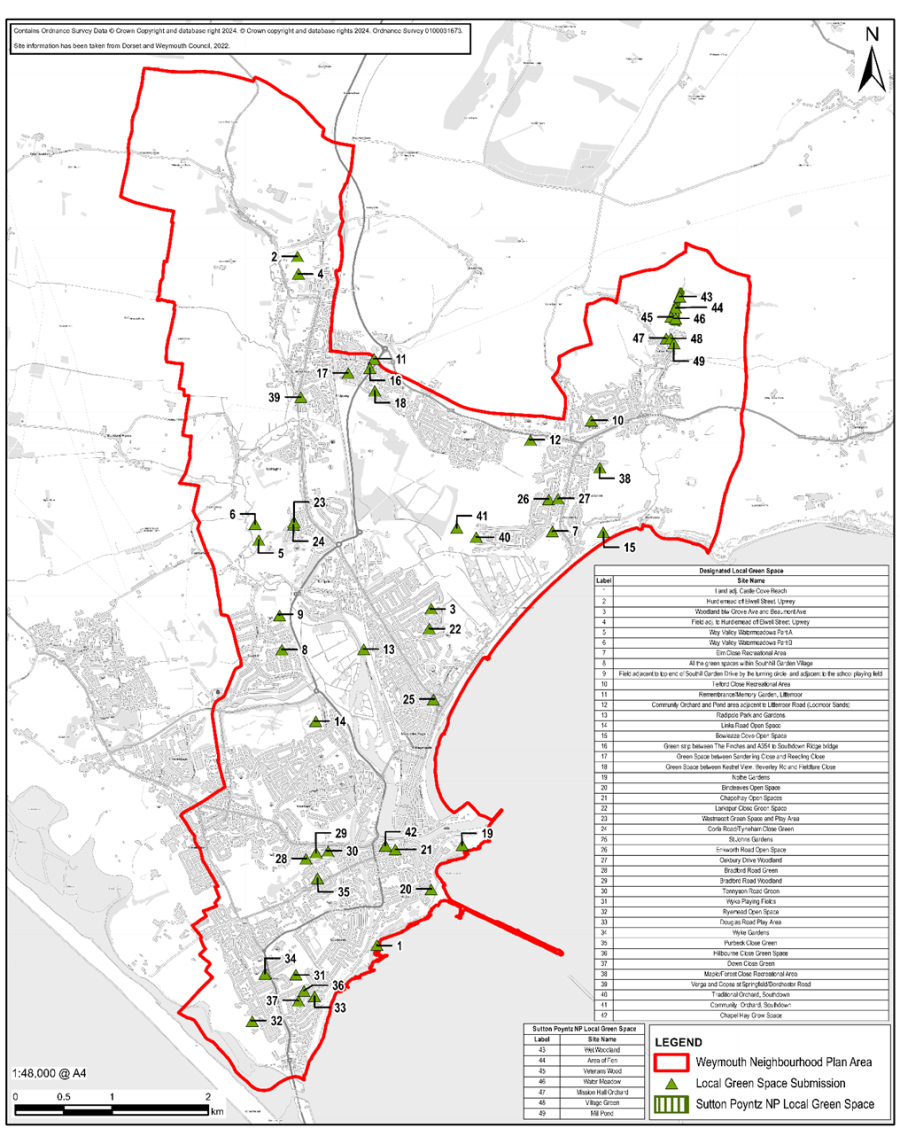
Policy W10: Local Green Space
The areas listed in Schedule 1 and shown on Map 12 and as defined on the accompanying Inset Maps at Appendix B are designated as Local Green Spaces. Development proposals in the designated Local Green Spaces will be managed in accordance with the national policy for Green Belts.
8.70 Local green spaces within the urban area provide important amenity and casual recreation space for residents and a valuable part of the overall green infrastructure, which contribute to the quality and distinctiveness of the local environment as well as safeguarding local biodiversity. Many of the local green spaces incentivise walking and physical activity and generally add to quality of life.
8.71 The NPPF (para. 105) gives us the right to designate amenity areas that are highly regarded as ‘local green spaces’ and give them protection for current and future generations via policies in the Neighbourhood Plan.
8.72 54 locations were submitted for consideration by the public along with seven areas from the made Sutton Poyntz Neighbourhood Plan and following assessment against the required criteria (paragraph 106 of the NPPF) a total of 49 are proposed for designation (see Map 12). Those listed in Table A: Schedule 1 below are under consideration as ‘Local Green Space’ in recognition of their importance to the amenity and wellbeing of their neighbourhood and to protect them for the continued enjoyment and appreciation by local people and visitors.55 They vary in character from formal gardens, informal play areas, to wilder amenity areas. They all share a similar regard by the people and communities that have nominated them and supported their designation.
8.73 Development on sites designated as local green space should be limited to that which is deemed appropriate by being ancillary to its existing use and small scale. ‘Very special’ circumstances to justify other forms of development will not exist unless the potential harm to the designated space by reason of inappropriateness, and any other harm, is clearly outweighed by other considerations such as where the public benefit would clearly outweigh the loss. In these instances, the local green space to be lost should be replaced by alternative green space that will benefit the community and the area. Several of the sites are maintained by Weymouth Town Council for the enjoyment of residents and have supported all of the proposed areas where they are the landowner.
8.74 The sites on Table A: Schedule 1 have been through a thorough process of assessment and consultation. They are designated as Local Green Space56 and subject to policy W10. Please refer to the individual site maps in Appendix B.
8.75 A number of these sites are deemed by the public to be of such great importance that they have also been addressed to varying degrees under other specific policies consistent with the reasons for their proposed designation.
Table A: Weymouth Neighbourhood Plan Local Green Spaces
| Map ref no. | Name and location of site | Brief Description | Area Ha | Is it an extensive tract of land? | Is it in close proximity to the community? | Reasons the area is demonstrably special | |||||
|---|---|---|---|---|---|---|---|---|---|---|---|
| Beauty | History | Recreation | Wildlife | Tranquillity | Other | ||||||
| Schedule 1: Weymouth Neighbourhood Plan Local Green Spaces | |||||||||||
| 1 | Land at Castle Cove DT4 8QB | Publicly accessible coastal cove and greenspace | 1.02 | No | Yes | Yes | Yes | Yes | Yes | Yes | Public access |
| 2 | Hurdlemead off Elwell Street, Upwey | Centrally located field with multiple footpath access regularly used by the community. | 5.70 | No | Yes | Yes | Yes | Yes | Yes | Public access | |
| 3 | Woodland area between Beaumont Avenue and Grove Avenue | Woodland area between Grove Avenue. | 0.53 | No | Yes | Yes | Yes | Yes | Public access | ||
| 4 | Adjoining fields adjacent to Hurdlemead, Upwey. | Rough pasture adjacent to village | 1.96 | No | Yes | Yes | Yes | Yes | Public access | ||
| 5 | Wey Valley Watermeadows part A, Nottington | Publicly accessible Watermeadows | 1.48 | No | Yes | Yes | Yes | Yes | Yes | Yes | Public access |
| 6 | Wey Valley Watermeadows part B, Nottington | Publicly accessible Watermeadows | 3.3 | No | Yes | Yes | Yes | Yes | Yes | Yes | Public access |
| 7 | Area of recreational land south of Elm Close DT3 6JN | Grassed recreational area with playground and woodland fringe in a residential area. | 1.25 | No | Yes | Yes | Yes | Yes | Public access | ||
| 8 | Interconnecting strips of grass verge between streets at Southill Garden Village | Multiple small open spaces between houses and roads that interconnect within the original Southill Garden Village. | 4.04 | No | Yes | Yes | Yes | Yes | Yes | Yes | Public access |
| 9 | Field adjacent to top of Southill Garden Drive by the turning circle and adjacent to the school playing field. | Publicly accessible open space close to a residential area. | 1.1 | No | Yes | Yes | Yes | Yes | Public access | ||
| 10 | Recreation Area off Telford Close, Preston | Grassed area with fruit trees and adjacent playground in a residential area. | 1.09 | No | Yes | Yes | Yes | Yes | Public access | ||
| 11 | Remembrance/Memory Garden at Littlemoor | Small open space. | 0.01 | No | Yes | Yes | Yes | Yes | Yes | Public access | |
| 12 | Community Orchard and Pond area adjacent to Littlemoor Road | Accessible wildlife area enclosed by hedge with path, community orchard and ponds. | 2.91 | No | Yes | Yes | Yes | Yes | Public access | ||
| 13 | Radipole Park and Gardens | Formal Park and Gardens close to residential properties. | 5.27 | No | Yes | Yes | Yes | Yes | Yes | Yes | Public access |
| 14 | Links Road Open Space | Publicly accessible open area with perimeter hedging and native trees close to residential properties. | 1.59 | No | Yes | Yes | Yes | Yes | Yes | Public access | |
| 15 | Open Space at Bowleaze Coveway | Green cliff top recreation area | 7.93 | No | Yes | Yes | Yes | Yes | Yes | Yes | Public access |
| 16 | Green Strip between the Finches and the A354 to Southdown Ridge bridge, Littlemoor | Green strip with trees adjacent to residential properties. | 0.54 | No | Yes | Yes | Yes | Yes | Yes | Public access | |
| 17 | Green Space between Sanderling Close and Reedling Close, Littlemoor | Green strip with culvert/stream adjacent to residential properties | 0.61 | No | Yes | Yes | Yes | Yes | Yes | ||
| 18 | Green Space between Kestrel View, Beverley Road and Fieldfare Close, Littlemoor | Green strip connecting residential areas on a large estate. | 1.13 | No | Yes | Yes | Yes | Yes | Yes | Public access | |
| 19 | Nothe Gardens/Peace Gardens | Green coastal cliff top recreational open space. | 5.01 | No | Yes | Yes | Yes | Yes | Yes | Yes | Public access |
| 20 | Bincleaves Open Space | Green coastal cliff top recreational open space | 1.51 | No | Yes | Yes | Yes | Yes | Yes | Yes | Public access |
| 21 | Chapelhay Open Spaces | Recreational green spaces adjacent to residential properties | 0.42 | No | Yes | Yes | Yes | ||||
| 22 | Larkspur Close Green Space | Recreational green space adjacent to residential properties | 0.18 | No | Yes | Yes | Yes | Yes | Yes | Public access | |
| 23 | Westmacott Estate Green Space | Recreational green space adjacent to residential properties | 0.18 | No | Yes | Yes | Yes | Yes | Public access | ||
| 24 | Corfe Road/Tyneham Close Green Space | Recreational green space adjacent to residential properties | 0.35 | No | Yes | Yes | Yes | Yes | Yes | Public access | |
| 25 | St Johns Gardens, Park District, Weymouth | Recreational green/growing space and community orchard | 0.13 | No | Yes | Yes | Yes | Yes | Public access | ||
| 26 | Green area between Enkworth Road and Oakbury Drive, Preston. | Recreational green space with mixed trees adjacent to residential properties | 0.18 | No | Yes | Yes | Yes | Yes | Yes | Yes | Public access |
| 27 | Woodland area off Oakbury Drive, Preston. | Publicly accessible woodland area adjacent to residential properties. | 0.29 | No | Yes | Yes | Yes | Yes | Yes | Yes | Public access |
| 28 | Bradford Road Green | Recreational green adjacent to residential properties | 0.11 | No | Yes | Yes | Yes | Yes | Yes | Public access | |
| 29 | Bradford Road Woodland Area | Recreational woodland adjacent to residential properties | 0.61 | No | Yes | Yes | Yes | Yes | Yes | Yes | Public access |
| 30 | Tennyson Road Green | Recreational green adjacent to residential properties | 0.07 | No | Yes | Yes | Yes | Yes | Yes | Public access | |
| 31 | Wyke Playing Fields | Sports and recreational area adjacent to residential properties. | 2.71 | No | Yes | Yes | Yes | Yes | Public access | ||
| 32 | Ryemead Open Space | Recreational open space adjacent to residential properties. | 1.67 | No | Yes | Yes | Yes | Yes | Yes | Public access | |
| 33 | Douglas Road Play Area and Open Space | Recreational open space with play area adjacent to residential properties. | 0.16 | No | Yes | Yes | Yes | Public access | |||
| 34 | Wyke Gardens | Formal gardens and recreational area close to residential properties | 0.37 | No | Yes | Yes | Yes | Yes | Public access | ||
| 35 | Purbeck Close Green | Recreational green adjacent to residential properties | 0.26 | No | Yes | Yes | Yes | Public access | |||
| 36 | Hillbourne Road Green | Recreational green adjacent to residential properties | 0.29 | No | Yes | Yes | Yes | Yes | Public access | ||
| 37 | Down Close Green | Recreational green adjacent to residential properties | 0.09 | No | Yes | Yes | Yes | Yes | Yes | Public access | |
| 38 | Forehill Maple Close Green Space | Recreational green /former equipped play area adjacent to residential properties | 0.11 | No | Yes | Yes | Yes | Yes | Public access | ||
| 39 | Verge and Copse at junction of Springfield/Dorchester Road | Woodland copse of wildlife value adjacent to residential properties | 0.16 | No | Yes | Yes | Yes | Yes | |||
| 40 | Traditional Orchard, west of Southdown Avenue | Former farmhouse orchard adjacent to residential area. | 0.06 | No | Yes | Yes | Yes | Yes | |||
| 41 | Community Orchard, near Southdown Avenue | Recently planted community orchard and grassland. | 1.16 | No | Yes | Yes | Yes | Yes | Yes | Public access | |
| 42 | Chapelhay Community Growing Space, Chapelhay Gardens. | Community open space in a residential area | 0.02 | No | Yes | Yes | Yes | ||||
| AREAS DESIGNATED AS LOCAL GREEN SPACE IN THE ‘MADE’ SUTTON POYNTZ NEIGHBOURHOOD PLAN | |||||||||||
| 43 | Wet Woodland | Woodland with River Jordan running through. | 0.60 | No | Yes | Yes | Yes | Yes | |||
| 44 | Area of Fen | Fen area with River Jordan running through | 0.54 | No | Yes | Yes | Yes | Yes | |||
| 45 | Veterans Wood | Mixed deciduous woodland with River Jordan running through | 0.27 | No | Yes | Yes | Yes | Yes | Public access | ||
| 46 | Water Meadow | Meadow with River Jordan running through | 0.96 | No | Yes | Yes | Yes | Yes | Yes | ||
| 47 | Mission Hall Orchard | Traditional orchard at the rear of a community hall | 0.03 | No | Yes | Yes | Yes | Yes | Public access | ||
| 48 | Village Green | Small green open space central to the village | 0.01 | No | Yes | Yes | Yes | Yes | Public access | ||
| 49 | Mill Pond | Former mill pond in the historic centre of the village | 0.09 | No | Yes | Yes | Yes | Yes | Yes | Public access | |
Map 12: Designated Local Green Spaces
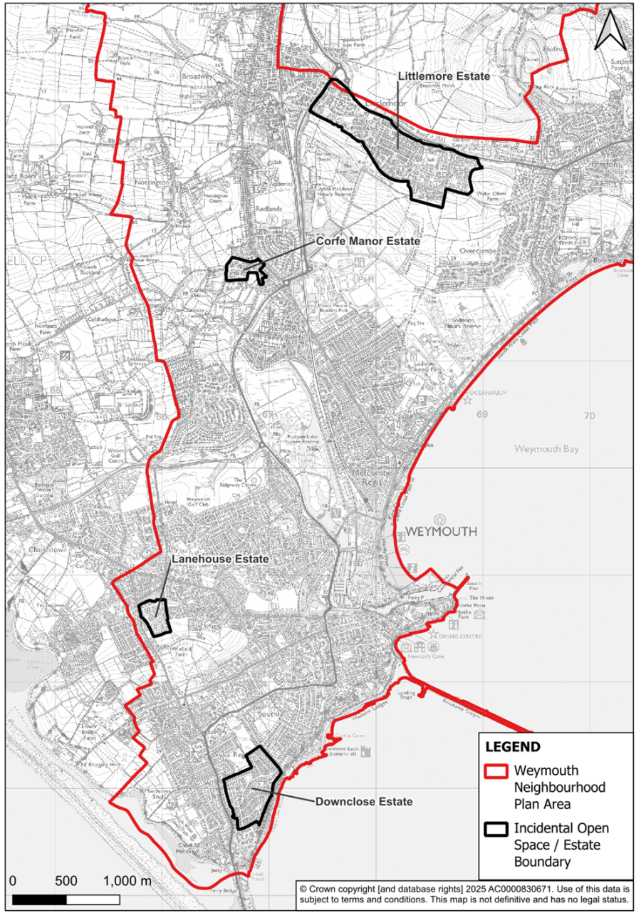
Policy W11: Incidental Open Space
Areas of incidental open space in residential areas that were designed as part of the layout to contribute to local amenity, character and/or green infrastructure should be protected from development except where:
i. new and appropriate alternative provision can be demonstrated to compensate for localised loss of public amenity and quality of life within the area concerns; or,
ii. it can be demonstrated that any damage to green infrastructure and/or local character can be satisfactorily mitigated, or the existing situation enhanced.
8.76 Several of the housing areas of Weymouth were designed and developed with areas of incidental open space included in the layout to provide amenity and/or a shared recreation space for residents. These, now mature, open spaces are part of the essential character of the residential areas. They are an integral part of the design of the estate and together form an essential part of its attractive open and green character and pleasant living environment. Some of the spaces are used for informal play. Several contribute to local biodiversity and form an important part of the green infrastructure by serving as green corridors through the built-up area.
8.77 Other estates are similarly recognised for their amenity spaces. In acknowledgement of their value and the purpose they were designed for, policy W11 applies to all areas of incidental open space within the residential areas listed below and shown on Map 13. The policy recognises all incidental areas within these residential areas as ‘sites of open space value’ and places a protection upon them unless the community they serve is supportive of their change of use. Each of the four estates which include Incidental Open Spaces are described and mapped individually in Appendix C.
Map 13: Estates with Protected Open Spaces
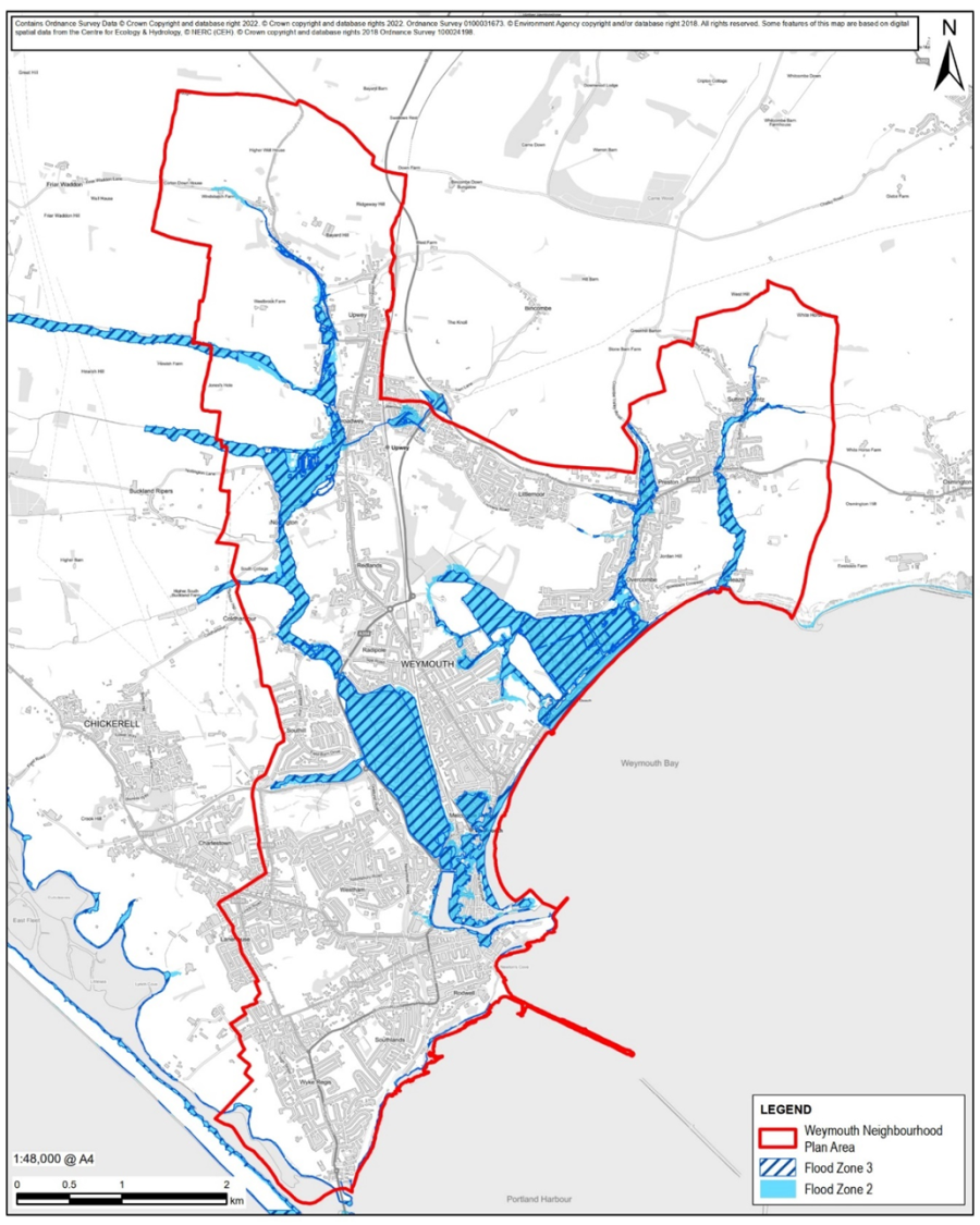
Policy W12: Riversides
8.78 The lower valleys of the River Wey and River Jordan and their tributaries form a natural infrastructure of green/blue corridors which play an important role in the life and wellbeing of the neighbourhood area and are of significant benefit to biodiversity. In general, and for good and bad, flood patterns follow the rivers. They provide vital drainage courses but are themselves prone to causing flooding because of tidal effects. Map 14 shows the area’s flood risk zones, within which the river courses are clearly identifiable.
8.79 Most of the land either side of the rivers is flood zone 3b. The NPPF (para. 165) makes clear that inappropriate development in areas at risk of flooding “should be avoided”. The Environment Agency identifies what it considers to be ‘water-compatible’ development that could take place in flood zone 3b. These include water-based recreation (excluding sleeping accommodation), and amenity open space, nature conservation and biodiversity, outdoor sports and recreation and essential facilities such as changing rooms. It may also include measures to ensure water quality is maintained or improved.
8.80 There is public support for an improved riverside walkway from Upwey to Weymouth. Large stretches of the current Wey Trail are not beside the river. Support for better access along the River Wey was confirmed in the community consultation in 2023.
8.81 The Sutton Poyntz Neighbourhood Plan identified a green corridor along that part of the River Jordan that runs through the Sutton Poyntz neighbourhood area. It is proposed to extend this green corridor and apply the related policies to the remainder of the River Jordan to its outfall at Bowleaze Cove.
8.82 Policy W12 recognises the recreation and education potential of the riverside areas, supports appropriate recreation and tourism schemes if they satisfy the Environment Agency, other relevant flood risk management authorities, and are deemed not to harm the ecology and wildlife habitats in the area. Measures to aid greater appreciation of the wildlife such as platforms, shelter and hides in appropriate locations are supported.
Map 14: Rivers and Inland Water
Policy W13: Panoramas, Vistas and Views
Development proposals likely to have a significant impact on the important public panoramas, vistas and views identified on Maps 15A – F and defined in the accompanying Tables should demonstrate due regard to the local design guidance available at that time and should be accompanied by a Landscape and Visual Impact Assessment (LVIA).
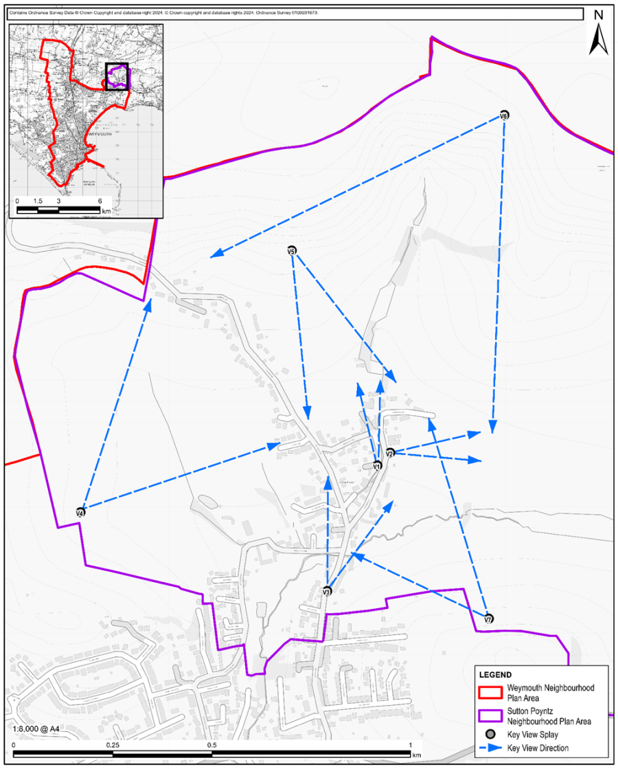
8.83 The value of panoramas, vistas and views has been highlighted by the work of the Sutton Poyntz Neighbourhood Forum. Key views within the Sutton Poyntz neighbourhood area were identified in the Sutton Poyntz Neighbourhood Plan57 and protected by a specific policy (H&P 3.2).
8.84 The seven views that are subject to Sutton Poyntz Neighbourhood Plan policy are identified on Map 15A. Other views within the Neighbourhood Area are shown on Maps 15B to 15F inclusive along with a description in the associated table of the viewpoint and panorama, vista and views.
8.85 Following the Regulation 14 consultation further views were suggested by the Weymouth Civic Society in addition to those contained in the pre-submission Neighbourhood Plan. These have been incorporated into Policy W13.
8.86 Each of the views is in accordance with the guidance established in consultation with the Local Planning Authority as follows:
Developers should be mindful of the impact their proposals could have on these historic and iconic views. Regarding these, design guidance will continue to be available in masterplans for the Town Centre, the sea front and the harbour.
8.87 Development proposals should demonstrate consideration of the area’s panoramas, vistas, and views that are highly regarded by the public, and an awareness of the potential impact of their development proposals on the visual character and amenity of the area by ensuring alignment with relevant design guidance and undertaking a Landscape and Visual Impact Assessment. Development should not impair or compromise significant panoramas, views, and vistas and where appropriate, show consideration of how it may frame a view or enhance the visual experience. Any development which would obstruct or significantly detract from them will not be supported.
Map 15A: Views and Vistas – Sutton Poyntz
| Key to Map 15A: Views and Vistas – Sutton Poyntz Abstracted from the ‘made’ Sutton Poyntz Neighbourhood Plan |
||
|---|---|---|
| Ref | Viewpoint | Description |
| V1 | From the stone footbridge over the village’s mill pond. | This view is considered important as it captures the essence of the village; it is the classic picture postcard view which includes the key characteristics of Sutton Poyntz. |
| V2 | From the Mill Pond towards White Horse Hill | This view gives a feeling of openness and connection to the hills beyond the village and is important as a backdrop to the Mill Pond which is the heart of the village. Any development in this area would detract from the centre of the village and remove its rural feel. This field and beyond towards White Horse Hill should remain as open space. |
| V3 | From the Sutton Poyntz stone towards the junction outside the Cart Shed | The view of the South Dorset Ridgeway and White Horse Hill has been partially obscured by infill development in the gateway to the village. Any future development will retain the narrow lane and protect the residual views. |
| V4 | North from the path below Chalbury | This view is important because it is framed by the houses on the hill running up Plaisters Lane. Any development in and around those existing houses should not stand out from the neighbouring properties and should not detract from this view. |
| V5 | From the Beacon below West Hill | This view is an important one for the village. There is a seat for walkers and this is a regular viewing point for those approaching the village on foot. It encompasses the whole village. Any development that can be seen from this point must enhance the DNL and reflect the traditional building styles within the village. |
| V6 | From Margaret’s Seat above Spring Bottom | Another important view for those approaching on foot. It encompasses the whole village and sets it in the landscape with the view of the sea in the distance. As for view 5 any development that can be seen from this point must enhance the DNL and reflect the traditional building styles within the village. |
| V7 | From Winslow | This was seen as a particularly important view by the independent assessor. It encompasses the whole village and sets it in the landscape with the South Dorset Ridgeway beyond. Again, any development that can be seen from this point must enhance the DNL and reflect the traditional building styles within the village. |
Map 15B: Views and Vistas – Weymouth / Melcombe Regis
| Key to Map 15B: Views and Vistas – Weymouth | ||
|---|---|---|
| Ref | Viewpoint | Description |
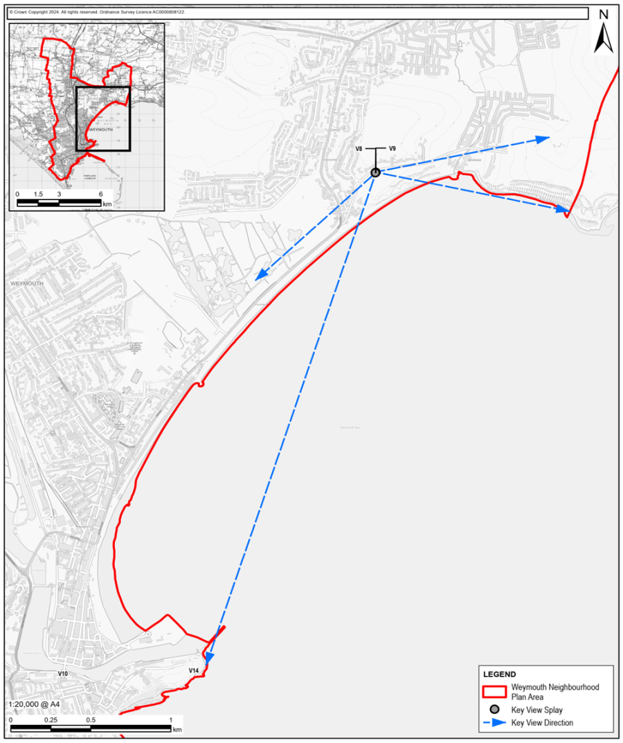
| V8 | Bowleaze Cove looking west from the ‘Lookout’ Café | View towards Lodmoor, Greenhill and the Georgian Esplanade and Harbour, taking in Weymouth Beach and Town Centre. |
| V9 | Bowleaze Cove looking east from the Lookout Café | Bowleaze Coveway Open Space eastwards along the coastal fringe towards Bowleaze and Bradrock. |
Map 15C: Views and Vistas – Melcombe Regis
| Key to Map 15C: Views and Vistas – Weymouth | ||
|---|---|---|
| Ref | Viewpoint | Description |
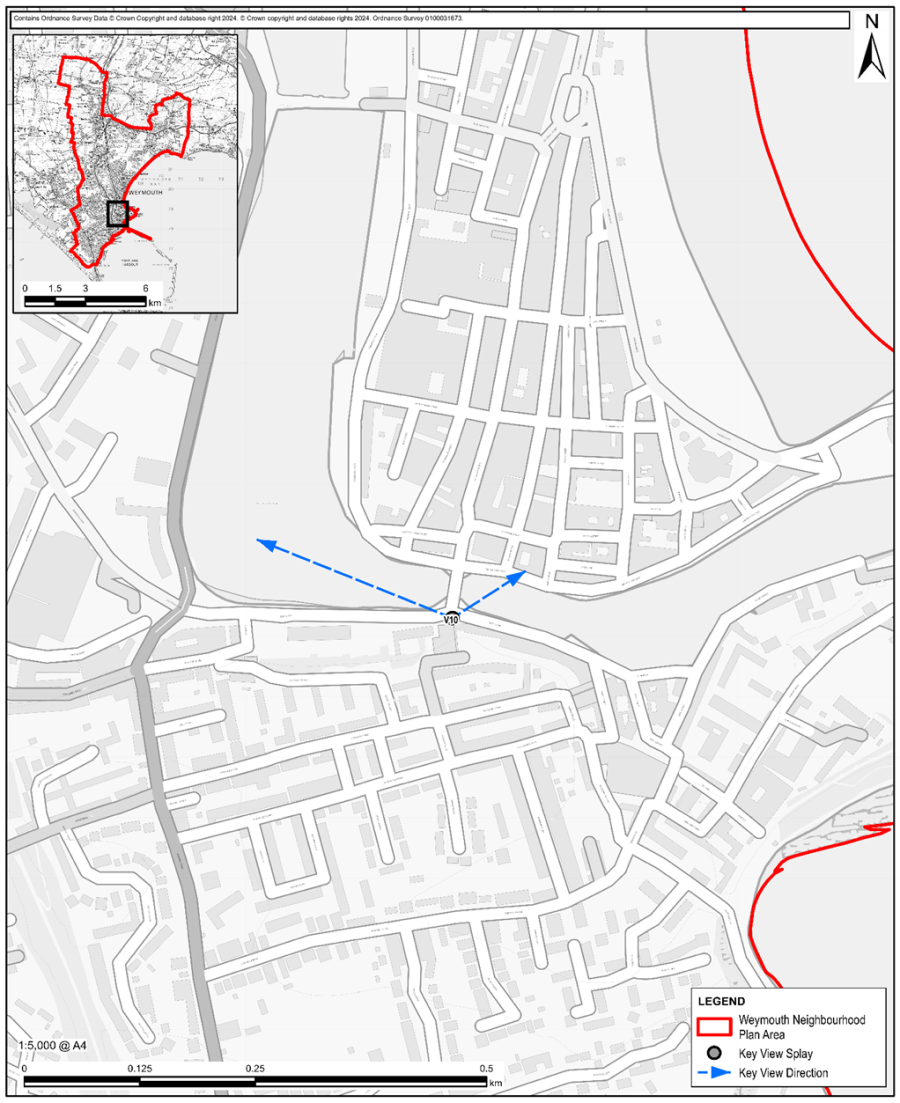
| V10 | Looking North from Chapelhay Steps | A view of the iconic Town Bridge and taking in part of the inner harbour (marina) with converted warehouses in the near background. |
Map 15D: Views and Vistas – Weymouth Coastline
| Key to Map 15D: Views and Vistas – Weymouth Coastline | ||
|---|---|---|
| Ref | Viewpoint | Description |
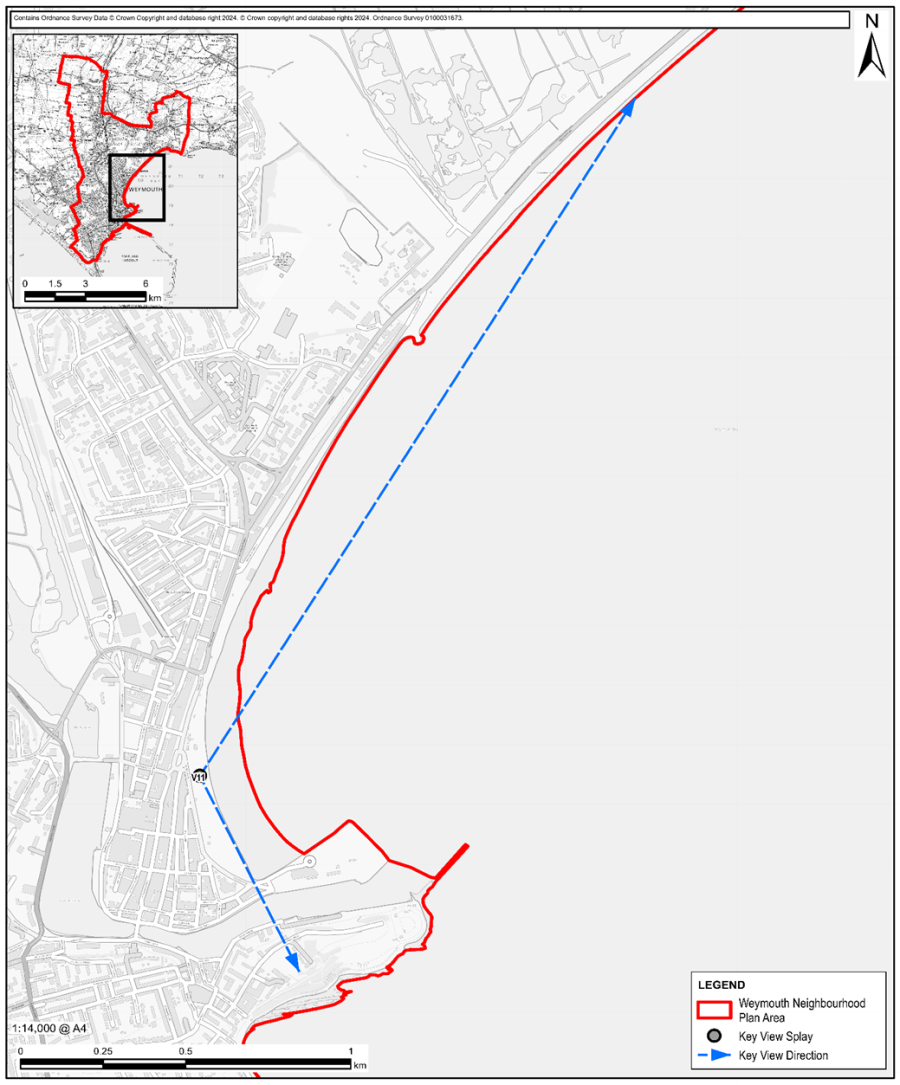
| V11 | The Esplanade near the Kings Statue | Looking eastwards along Weymouth Bay towards the coastal cliffs including Bowleaze Coveway Open Space and Broadrock and westwards towards the Pavilion Peninsula and the Nothe Fort and Gardens. |
Map 15E: Views and Vistas – Across Weymouth Harbour
| Key to Map 15E: Views and Vistas – Across Weymouth Harbour | ||
|---|---|---|
| Ref | Viewpoint | Description |
| V12 | Top of Nothe Steps in Nothe Fort Gardens | View along the Quayside and across the Harbour, towards the Georgian Esplanade and Greenhill Gardens; the gap between the Round House and Pavilion Theatre is important, linking the harbour and beach. |
Map 15F: Views and Vistas – Newtons Cove
| Key to Map 15F: Views and Vistas – Newtons Cove | ||
|---|---|---|
| Ref | Viewpoint | Description |
| V13 | Outside Nothe Fort | Looking south-westwards across Newton’s Cove towards Bincleaves. |
| V14 | Bincleaves Open Space | Looking north-east towards Newton’s Cove and the Nothe Peninsula. |
33 SSI = Site of Special Scientific Interest
34 Dorset AONB Management Plan 2019-2024
35 2nd Engagement – WNP Consultation Feedback Report – October 2022
36 Dorset Council Shoreline Management Plans
38 Weymouth Level 2 Strategic Flood Risk Assessment - Dorset Council
39 Weymouth Neighbourhood Plan HRA – November 2024
40 Dorset Council - DBAP Technical Guidance Section 3 - Mitigation
41 Dorset Council-Dorset's local nature recovery strategy
42 Dorset Environment Records Centre - Urban Wildlife Corridors & Stepping Stone - Sept 2010
43 Weymouth & Portland - Addendum Sept 2020
44 Dorset Council - The Dorset Biodiversity Appraisal Protocol
45 Gov.UK - Biodiversity Net Gain: Exempt Developments Guidance
46 Local Govt - Process for developing a 20% BNG Policy
47 Guildford BC - Biodiversity Net Gain
49 WTC - Parks & Open Spaces Biodiversity Policy
50 UK BAP Definition - Biodiversity
51 WTC - Tree Management Policy 2021-2025
52 Dorset Council Tree Preservation Orders in Weymouth & Portland
54 Ramblers Charter for Walking Neighbourhoods
55 Local Green Space Assessment Report
57 Independent Assessment of Key View Designation: SPNP
< Previous | ^ Top | Next >