
To maintain, protect and improve the beauty, tranquillity and accessibility of our rural landscape, together with its diverse wildlife, that residents and visitors value so highly. To protect vulnerable habitats from the impacts of climate change and build climate resilience. To play its part in tackling climate change and helping the UK to reach its goal of net zero emissions by 2050 through the protection and enhancement of its trees, woodland and forest. Key policies:
Projects:
|
3.1 Stinsford parish has a far greater wildlife value than perhaps suggested by its small size. It hosts a range of different habitats, including patches of ancient and broadleaved woodland; the water meadows associated with the River Frome along the southern edge of the plan area (which is a nationally designated wildlife site1 ), the calcareous grassland around Waterston Ridgeway in the north, and the dry heathland edging Thorncombe Wood in the east. Thorncombe Wood is a mix of ancient and deciduous woodland and heathland, and has been designated as a Local Nature Reserve. All of these habitats in turn host a wide variety of birds, insects, invertebrates, fish and mammals. For example, kingfishers can be seen along the river, there are owls hunting at dusk, as well as signs of badgers and smaller mammals include the dormouse, water vole and the water shrew. More information on the range of notable wildlife species found in the parish is described in Table 1, and more details are included in Appendix 1.
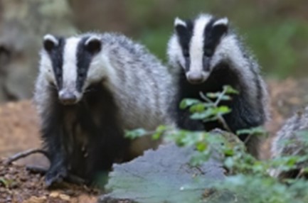
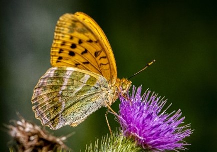
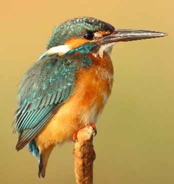
Table 1. Wildlife research findings
Mammals |
Badgers, foxes and roe deer are quite frequently sighted when they emerge from cover, and otters have made a major comeback - a DEFRA survey of 2001/2002 reported widespread signs of them on the River Frome. Occasional sightings continue to be made along the river near to Lower Bockhampton. Smaller mammals include the dormouse, the water vole and the water shrew. |
Birds. |
Many of the bird species are associated with water: notably Kingfisher, Water Rail, Grey Wagtail, Marsh Tit and Mute Swan; also Reed, Sedge and Cetti’s Warblers. Local raptors include Little, Barn and Tawny owls as well as Sparrow Hawks and Kestrels, with Buzzards being the most often seen. Nightjars are seen and heard each summer on the heathland. Large numbers of Jackdaws gather in the oriental Plane Tree next to Stinsford Church, before roosting on nearby roofs, and there is a large rookery next to the A35 south of Higher Kingston Farm. |
Reptiles and Amphibians |
All 3 British Snakes - Adders, Grass and Smooth Snakes - have been sighted; and Palmate and Smooth Newts are found in a number of our ponds. |
Butterflies and Moths |
Butterfly Conservation has recorded 28 butterfly species within the parish: of these, the most spectacular is the Silver Washed Fritillary (Thorncombe Wood), a species noted for its spectacular courtship flight; a less common species is the Silver Studded Blue found on the dry heath near Thorncombe Wood |
Insects and Spiders |
The Green Tiger Beetle is noted on the dry heath near Thorncombe Wood. The watery habitats are good for dragonflies including Emperor and Golden Ringed Dragonflies, and the less common Four Spotted Chaser. Also associated with water are the Wolf Spider and the more fully aquatic Raft Spider - one of Britain’s largest species. |
Fish |
With good water quality reported there are a number of species seen including Brown Trout and Salmon. Grayling , Dace and Roach breed in the Stinsford Branch of the River Frome. Eels and Lampreys have been seen. |
3.2 Research2 has shown that, whilst Dorset is particularly rich in wildlife (and this in itself attracts a large numbers of tourists, who benefit the local economy), Dorset’s environment has been seriously degraded over the past 80 years, for example through the significant loss of neutral and calcareous grasslands, impacts of nitrogen deposition and habitat fragmentation. This is likely to apply equally to Stinsford. Whilst a lot of this is due to changing agricultural practices, these impacts and possible mitigation measures are something that this Neighbourhood Plan must take into account.
3.3 The Government is intending to set a minimum 10% net gain in biodiversity in all planning applications as part of the Environment Bill currently working its way through Parliament. Dorset Council requires the submission of a certified Biodiversity Mitigation Plan in cases where the site size exceeds 0.1ha and on smaller sites where there could be important habitats or protected species present (for more details please refer to their validation process), and seeks to ensure a net biodiversity gain through such mechanisms.
3.4 Sustainably managed woodland plays a key role in tackling climate change by absorbing carbon dioxide (CO2) from the atmosphere and locking it away for centuries. In addition to the areas of Ancient Woodland (as identified in Natural England’s inventory) we have also identified areas of local historic woodland using local knowledge checked against historic maps from the turn of the 20th century. Increasing tree and woodland cover and other initiatives such as protecting our soils (which also store carbon) can not only help combat climate change but also provide wider environmental benefits.
3.5 Poole Harbour (which the River Frome flows into) is an important, internationally protected wildlife site, but has been deteriorating due to the increased nitrogen levels from sewage and agricultural practices in the surrounding area that gradually make their way to the harbour. As all of Stinsford parish is within the catchment zone of Poole Harbour, by law all new residential development, tourism attractions and tourism accommodation will need to be nitrogen neutral. This can be achieved via improvements to sewage treatment mechanisms so that they remove more nitrogen, or through changing the management of agricultural land to a use that requires less nitrogen input3 .
3.6 The heathland in the eastern part of the parish (primarily Black and Bhompston Heaths, to the east side of Thorncombe Wood) is an important wildlife habitat, albeit fragmented from the protected heathlands further to the east (in areas such as Warmwell and Tadnoll). These areas are particularly vulnerable to recreational pressures, and to climate change from drought and increased temperatures. As Lower Bockhampton and Bhompston lie within 5km of internationally protected heathland sites4 , by law all new residential development within this zone will need to ensure that it does not give rise to further recreational pressures on the protected heathland5 .
Policy SNP1. Protecting and strengthening our local wildlife and habitats Development must protect and, where practicable, enhance biodiversity to secure an overall biodiversity gain, taking into account the existing wildlife interest and habitats in the local area, and how these are under threat (for example through land / forestry management practices, water resource management, recreational pressures and climate change).
Development must avoid having an adverse effect on the integrity of internationally important wildlife sites. The loss of ancient and local historic woodlands and the loss of heathland habitats within the parish will be strongly resisted. |
3.7 Many of the woodlands, large and small, consist of ageing trees and there are concerns that without a management plan and replacement planting, many of these could become depleted to the detriment of the landscape quality of the parish. It is also unclear to what extent recreational pursuits in woodland areas (such as mountain biking and horse riding) may be having a detrimental impact on their biodiversity. A survey of the parish's woodlands, particularly focusing on those that are not in active management or where there is significant recreational use, is therefore suggested as a first step to understanding these potential threats.
3.8 It may also be possible to utilize public spaces (e.g. recreational areas and verges) and work with local landowners to improve climate resilience and enhance the environment through rewilding and other initiatives.
Project P1. Woodland Survey and Planting The Parish Council will investigate undertaking a survey of the parish's woodlands, so that appropriate management can be encouraged. The Parish Council will work with landowners, businesses and residents to:
|
3.9 Stinsford parish lies almost entirely within the Dorset Downs and Cranborne National Character Area6 , much of which has been designated as a nationally important landscape. However the parish itself lies just beyond the Dorset Area of Outstanding Natural Beauty (AONB), which runs through the Piddle Valley at Piddlehinton to the north of the parish, and to the south side of the A352 through Winterborne Came and Whitcombe. The AONB was designated more than 60 years ago (in 1959), and at that time Stinsford parish was excluded despite areas such as Waterston Ridge having much the same topography and characteristics. The case for a National Park for Dorset7 highlights the importance of Egdon Heath and Stinsford parish, in that this landscape forms ‘the heart of Hardy’s Wessex’ – and suggests that, if it is to be preserved for posterity, then the parishes of Stratton, Charminster, Stinsford and Puddletown, that currently lie outside of the AONB, all need to be protected.
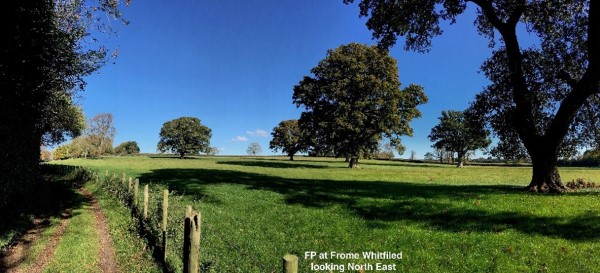
3.10 The landscape of Stinsford parish is characterised by contours that create discrete parcels of land, which in turn hide and reveal many beautiful vistas, crisscrossed by ribbons of hedgerows subdividing the field systems and a scattering of woodlands.
3.11 The varied topography, soils and history have brought about a rich mix of landscapes, primarily based on small-scale farming, with very few large fields (the average field size is around 10ha), with many of the boundaries relatively unchanged from Saxon times.
3.12 The parish has three main landscape types (as defined in the local landscape character assessments undertaken by the Local Planning Authority8 ), whose main characteristics are described in Table 2 below:
Table 2. Local landscape characteristics
Landscape characteristic |
river pasture |
chalk |
heath / forest |
|---|---|---|---|
peaceful, tranquil character |
✔ |
in part * |
in part * |
small, dispersed settlements, separated by large undeveloped areas |
✔ |
✔ |
✔ |
rural lanes that run along historic transport routes |
✔ |
✔ |
|
intricate network of public rights of way and private access tracks |
|
|
✔ |
predominantly open landscape |
✔ |
✔ |
|
relatively small-scale fields bordered by hedgerows |
✔ |
in part |
|
water channels / meadows and associated historic structures |
✔ |
in part |
|
small deciduous woodlands / copses, including ancient woodland |
✔ |
in part |
|
extensive tree cover |
|
|
✔ |
patches of lowland heath |
|
|
✔ |
* the tranquillity is disturbed within the A35 noise corridor - http://www.extrium.co.uk/noiseviewer.html |
|||
3.13 It is important that development respects the local landscape characteristics. The peace and tranquil nature of the area was a particular characteristic noted by local residents – although the areas closest to the A35 main road are affected by noise from the traffic using the A35 main road.
3.14 The river valley pasture landscape (including the Land of Local
Landscape Importance (LLLI) identified in the adopted Local Plan) and the separation of the settlements and open spaces between these is shown diagrammatically on Figure 2. In particular the notably vulnerable gaps, as listed in Table 3, are considered particularly fragile due to their limited length. Whilst there may be a general policy of restraint towards development in the open countryside, some development (such as new farm buildings) may still be permitted, and it is therefore important that such development does not take place in these most vulnerable gaps.
Table 3. Important Open Gaps
Gap |
Description |
Length |
|---|---|---|
Frome Whitfield to Lower Burton |
The gap between Frome Whitfield and Burton has historically been quite narrow, with part of the gap located beyond the Neighbourhood Plan area. Whilst farm buildings along the westward-leading track have been converted and added to, further infill, or development on the fields to the north, would be particularly harmful in reducing the feeling of separation between these two settlements. |
< 200m |
Frome Whitfield to Dorchester |
Whilst most of the gap here is within the flood plain, and therefore is unlikely to be developed, the prospect of a northern extension to the town could increase pressure for infrastructure through this gap which would diminish its value as a gap. |
500m |
Kingston Maurward and Lower Bockhampton to Higher Bockhampton |
The northward extension of Kingston Maurward College towards Bockhampton Cross has greatly reduced the feeling of separation between the two Bockhamptons. There has also been pressure for further development at and around Hampton Farm Business Park and Greenwood Grange. Given the rural setting of the Cross and the rising topography, further infill development to the north side of the Cross would be particularly harmful. |
800m |
Lower Bockhampton to Bhompston |
The gap between Lower Bockhampton to Bhompston has historically been quite narrow, and further diminished with the westward spread of farm building at Bhompston. Further development, particular within the undeveloped field to the east of Lower Bockhampton Farm, would be particularly harmful in reducing the feeling of separation between these two settlements. |
200m |
3.15 The gap between Stinsford and Lower Bockhampton is also not specifically listed in Table 3 – as its character is primarily related to the presence of the Elizabethan Manor and Kingston Maurward House and their associated grounds, and these grounds are statutorily designated on the Register of Parks and Gardens of Special Historic Interest in England. Today much of this area is part of the College’s estate, and any development would need to respect the particular historic significance of the gardens and parkland.
3.16 All of the river valley pasture has a particularly rural, agricultural feel, and this characteristic is central to the setting of the string of settlements along its length, as well as the wider setting of Dorchester. Whilst no decision has yet been made on the possible northern extension to Dorchester, there would be a clear tension between trying to locate development close to the town, whilst respecting this river valley landscape setting.
Figure 2. Key landscape characteristics and green gaps diagram
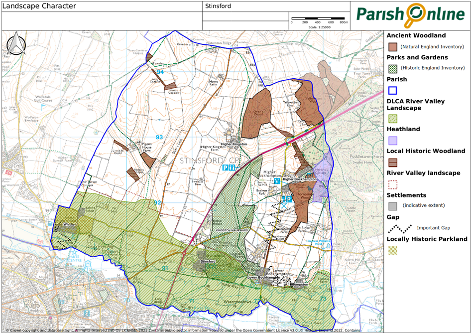
3.17 The gap between Frome Whitfield and Cokers Frome is not specifically listed in Table 3, because Cokers Frome is not a settlement in the same historic or current sense, and its associated buildings are much more scattered and considered to be part of this river valley landscape. It should however be noted that the remnants of parkland associated with Frome Whitfield House, containing a number of specimen trees, adds a particular character to this area. This has created an ornamental agricultural appearance, recognized in the 2018 Local Plan options consultation as significant to the setting of Dorchester’s Conservation Area. In the recent past a number of the trees have been lost.
3.18 Opportunities should be taken, where possible, to enhance the rural character of the area. In particularly there are opportunities for planting to help screen some of the larger buildings that have intruded into the more open countryside. For example, the replacement planting of the parkland trees at Frome Whitfield would help reinforce the historic landscape character of this settlement, and native hedgerow and tree planting to the south side of Mellstock Business Park would bring about substantial benefits in screening the business units. Similarly additional landscaping around the Studio School would help reduce its impact on the rural setting of Bockhampton Cross.
3.19 Even if the proposed northern extension of Dorchester is agreed through the Local Plan, the following policies would still be relevant in terms of guiding the masterplan for the site, in particular with regard to the treatment of the settlement edges, the design of new or upgraded routes (including any associated lighting) and the retention of landscape features that would be appropriate to ensure that such development respects the area’s character.
3.20 Information on the historical and cultural links to the landscape is included in section 4.
Policy SNP2. Local Landscape Character Development will respect and where possible enhance the rural character of the local landscape. In particular:
|
Policy SNP3. The Landscape Setting of the Settlements The string of small settlements along the river valley should retain their individual character, and care should be taken to avoid reducing the undeveloped nature of the gaps between the settlements, particularly with reference to those described in Table 3. The characteristics of the river valley pasture landscape (including those characteristics identified in Table 2), which provide the setting for Dorchester and the Stinsford river valley settlements, should be respected. |
3.21 The level of traffic on the A35 (which at the last count in 2017 was about 33,000 vehicles on an average day9 ) and the road surface treatment, which uses concrete in part, mean that the A35 is the main source of noise in the parish. Whilst the levels of traffic are unlikely to reduce in the future, a different re-surfacing could reduce noise levels, and the Parish Council will continue to lobby for this with Highways England.
Project P2. Noise-reduction measures on the A35 The Parish Council will continue to lobby for noise-reduction measures on the A35. |
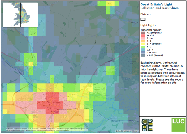
3.22 The area enjoys dark night skies for the most part, as illustrated on the following map (courtesy of the CPRE / LUC) although light spill from Dorchester does intrude into the parish. There is hardly any street lighting in Stinsford, and no desire for this to change.
Figure 3. Stinsford’s Light Pollution and Dark Skies: Nightblight
3.23 Whilst there are limitations on what can and cannot be achieved10 , this shouldn’t stop us from encouraging the best approach for our area. Where lighting is considered necessary, the choice of lighting should consider how best to avoid light spillage and glare. Movement sensitive and timed PIR lights, down-lighters or ‘wall washers’ are examples of lighting schemes that generally have less adverse impact whilst providing appropriate illumination. In general, light sources should be fully shielded and pointed downwards, so that light is not emitted above the horizontal.
Policy SNP4. Dark Skies Development should be designed to retain the dark skies, through minimizing exterior lighting / illuminations and including measures to control light spillage and glare, particularly in areas of open countryside and on the edge of settlements. Street lighting should not be provided in developments unless required to address site-specific safety or operational issues. |
3.24 Whilst “beauty is in the eye of the beholder”, some aspects of the landscape within the parish have universal appeal. This is reflected in the consultations on the plan, which show how much residents value the peaceful rurality of the parish. As part of the 2019 Residents Survey, we asked people to tell us about their favourite views in the parish. The views suggested naturally reflect those parts of the parish that people tend to visit more – such as those areas closest to the settlements and well-used rights of way. The findings in particular highlighted that views from the Frome river path across the associated water meadows are very popular, as is the southerly view from the Roman Road in Thorncombe Wood. Views from less well-trodden paths may have received fewer mentions, but perhaps are no less deserving of protection.
3.25 The main views are shown in the following map and described in Table 4. Other views also mentioned by local residents are noted on the map.
Table 4. Important Local Views
Viewpoint/s |
Description |
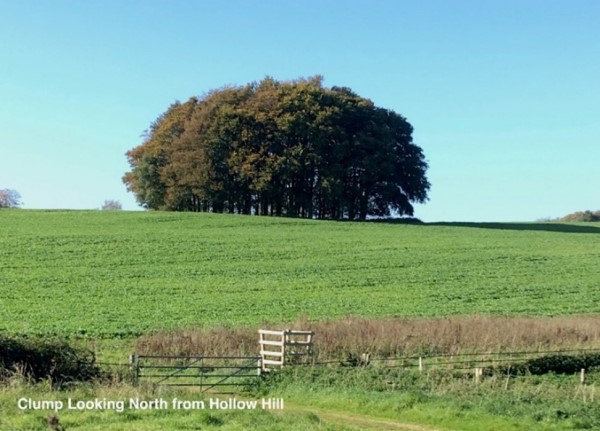
1. Hollow Hill |
1A: To the north the view includes the Roman road (adjacent to the viewing point), the prominent tree clump within Kingston Maurward’s parkland, and the rise of the chalk above the quarry (close to the viewpoint). The footpath was frequented by Hardy on his walk from the Cottage to Dorchester. 1B: To the south the focal feature is Kingston Maurward House, considered to be the Knapwater House in ‘Desperate Remedies’; and it also features as the Manor in ‘Under the Greenwood Tree’. |
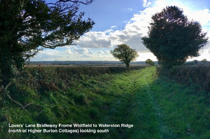
2. Lovers’ Lane |
2A: View south-east from the old drove road into secluded chalk valley, and expansive view south towards Dorchester’s skyline. 2B: View to south and east from Lovers’ Lane over Dorchester to the South Dorset Ridgeway beyond, with iconic landmarks of Dorchester including the Listed Buildings of Art Deco period County Hall with its copper roof, and St George's Church in Fordington. 2C: Looking south down the former drove road, with the well-treed landscape of the historic parkland of Frome Whitfield in the middle distance, and the Dorchester skyline beyond, including St George's Church in Fordington. 2D: View east from a ford with raised walkway beside, through a kissing gate (a feature often mentioned in Hardy literature) the footpath to the east follows the Frome Valley across relic historic parkland with ancient oaks. Looking south the towers of the church spires and tall chimneys of Dorchester’s skyline can be seen. 2E View from Blue Bridge looking northwards across an intimate view of the convergence of the Cerne and Frome rivers, beyond which lies Chapel Close field which is the site and remains of the medieval village of Frome Whitfield and St Nicholas Church (the view of the site of the medieval village is also possible from the footbridge to the north). |
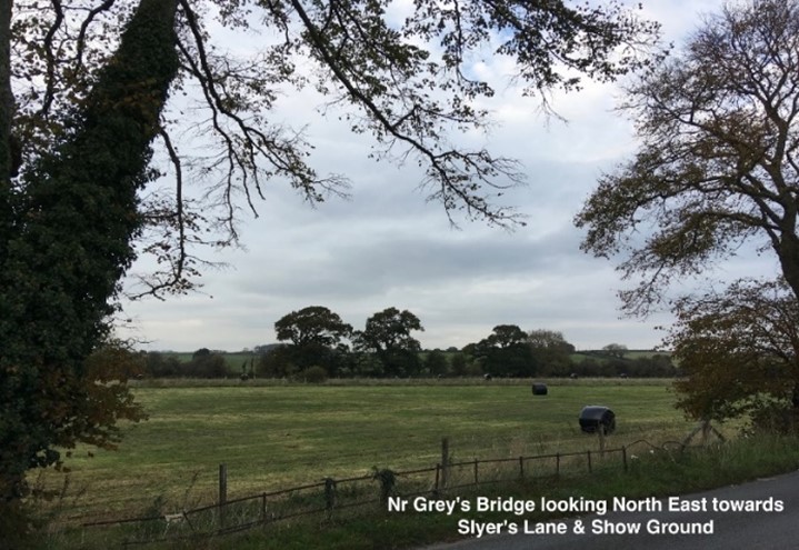
3. River Frome Walk |
3A: From the river path near Bockhampton Bridge, looking north-easterly to Bridge Cottage House (considered the prototype of Farmer Shiner’s cottage in ‘Under the Greenwood Tree’). The area downstream is a view into Tess of the d’Urbervilles “Valley of the Great Dairies” and to the right is where Angel Clare carried the milk maids across the water on their way to church. 3B: From Stinsford Ford looking east along the embowered path featured in Hardy’s The Dead Quire and in Under the Greenwood Tree (and you can also see the leat taking the water to Kingston Maurward Lake) 3C: looking west giving views of Three Bears Cottage (the gardener’s cottage for the Stinsford Estate) and across the water meadows, with its ditches, remains of sluices and low bridges. Further along the path there are views north to Stinsford House. 3D: From Grey’s Bridge looking eastwards, across the water meadows, and Hardy’s ‘Durnover Moor’ in the Wessex novels. 3E: From Grey’s Bridge looking northwards, features being the old natural swimming pool, the hatches, and Hatch Cottage – remnants of the historic management of the water meadows and a pool historically used for recreation. |
3. River Frome Walk (continued) |
This is an area associated with many characters in Hardy’s novels and poems – Michael Henchard in ‘The Mayor of Casterbridge’, Fanny Robin pausing on her way to the Union Workhouse, or Farmer Boldwood going to the prison in “Far From the Madding Crowd”. |
4. Top of Exhibition Field |
The view south-west over the Exhibition Field which was used for the Bath and West and Southern Counties Show in the late 1800s and early 1900s. Beyond is “Mellstock” Lodge and the Stinsford Park and water meadows with historic Horse Chestnut and Sycamore trees and the footpath often taken by the young Hardy on his daily walk to and from Dorchester. The poem “the Third Kissing Gate” refers to this. Along the road and up ‘Mellstock’ Hill is the re-created avenue of Limes, and beyond this Dorchester with Admiral Hardy’s Monument in the distance. |
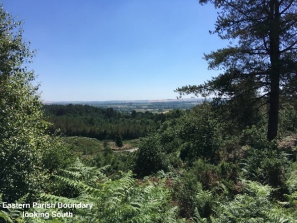
5. Thorncombe Wood Roman Road |
Looking south-west, with Rushy Pond and its associated poem “At Rushy Pond” close by, are views down the Roman Road and across rare heathland habitat, part of Hardy’s Egdon Heath, which features in ‘The Return of the Native’ “Ever since the beginning of vegetation its soil had worn the same antique brown dress”. |
6. Waterston Ridge Way |
6A: From a point beside Fiddlers Green (the remains of Shepherd Fennel’s home in the story Three Strangers) and close to one of the many tumuli along the ridge, looking south towards Cokers Frome Road (the view mentioned in the poem The Revisitation, with to the East the Piddle Valley Road (‘the grey, gaunt, lonely Lane of Slyre’)). 6B: A view from west of Slyers Lane (the Piddle Valley road), looking south over Dorchester towards the South Dorset Ridgeway, with further west the now distinctive profile of Poundbury. Maiden Castle, Britain’s (and Europe’s) largest Iron Age Hill Fort occupies the middle distance. The skyline is punctuated by the numerous Bronze Age burial tumuli clearly visible along the crest of the South Dorset Ridgeway leading the eye west to Hardy’s Monument at the top of Black Down. 6C: A view east of Slyers Lane, looking south-east towards the ancient woodlands of Grey’s Wood and beyond to Yellowham Wood, an area which features in Hardy’s novel Far from the Madding Crowd. |
7. Kingston layby on A35 |
Looking south from the A35 adjacent to Higher Kingston, a sweeping view into Kingston Maurward parkland, with Kingston Maurward House as the focal point. |
3.26 It would not be possible or indeed appropriate to stop any development within these views, particularly in the long term if the northern extension of Dorchester is given the go-ahead (which would be apparent from a number of the viewpoints suggested). Nor is it possible to identify every viewpoint that residents enjoy. However it is important that the impact of development on these views is properly balanced in the planning decision, with moderate to significant weight given to their protection. In particular, attention should be paid to the extent to which the enjoyment of the view may be impacted, taking into account the focal points and/or wide expanse of the view and the number of people who regularly enjoy the view. It may be possible, through landscaping or the careful siting, scale and design of development, to significantly reduce the adverse impact of development.
Figure 4. Map of Important Local Views
Policy SNP5. Protecting our important local views Development that would have a significant adverse impact on an Important Local View (as shown on Figure 4 and described in Table 4) should be avoided, unless there would be a clear and over-riding public benefit and all reasonable measures have been taken to mitigate the impact. |
3.27 The parish is crisscrossed by a comprehensive network of footpaths and bridleways giving access to the countryside to walkers, horse riders and cyclists. This brings multiple benefits, for health (both in terms of people’s physical and mental well-being), the local economy (as a major resource and attraction for visitors who may stay locally or use the local services) and wildlife (which uses the green corridors these routes create). They are also important in providing access to some of the most spectacular views in the area (see Table 4 in locally important views).
Did you know… Dorset Council is responsible for maintaining the surface of rights of way according to their status, and clearing any surface vegetation or undergrowth from the path. Landowners are responsible for cutting back hedges, trees or shrubs overhanging a public right of way. Landowners are responsible for maintaining stiles or gates, but Dorset Council may help with funding. To report a problem - https://mapping.dorsetcouncil.gov.uk/rightsofway/reportproblem |
3.28 However these paths and places are themselves vulnerable to over-use, as has been witnessed along the River Path which has been eroded in places (as a result of the level of users and localized flooding). Likewise, visitors to Thorncombe Woods (which is next to the National Trust visitor attraction of Hardy’s Cottage) have increased significantly in recent years, and whilst income generated can help fund the site’s management, it is important that increasing the number of visitors does not adversely impact on the biodiversity and quiet enjoyment of this site. There are also some paths on the network that end on, or have to cross, a busy highway, where the highway verge is not particularly safe.
3.29 Whilst the amount of housing development required to meet local need within Stinsford is unlikely to trigger the need for additional recreational open space provision, further pressure on the existing sites could potentially arise from the further expansion of the school, visitor pressure and the growth of Dorchester’s population. It is highly unlikely that improvements to the existing sites would mitigate this impact, and indeed our existing open spaces such as Thorncombe Wood may struggle to cater for any increase in demand, to their detriment. It is therefore important that further sites for additional open space of an appropriate quality are identified and brought forward in a timely manner to soak up any such increase in demand.
Policy SNP6. Encouraging appropriate recreational access to the countryside The improvement and expansion of the existing public rights of way network, permissive paths and open access land within the parish will be supported, and should focus on:
Development that would adversely impact on access to, and the health and wildlife benefits of, the public rights of way network in the parish will not be supported. Where new development would generate an adverse level of demand on the existing recreational network of accessible green spaces and rights of way, additional provision will be sought in order to mitigate any substantial cumulative harm, at a level appropriate to the scale and likely impact of the development. |
3.30 The current adopted standards for natural and semi-natural greenspace11 suggests a requirement of 5ha per 1,000 person. For the County Town of Dorchester12 , this would suggest a requirement of at least 105ha accessible natural greenspace in easy reach of the town, rising to over 160ha if the town grows to the extent that the Draft Local Plan proposes. At the current time, the main open access areas around Dorchester are:
3.31 Kingston Maurward College is investigating the improvement of signage and route marking across its estate, linking from Hardy’s Cottage at the north-eastern edge of the estate to his house, Max Gate, in Dorchester. Other suggestions raised through the Neighbourhood Plan include the potential for a safer link to West Stafford, as Bockhampton Lane can become busy when used as a cut through and is relatively narrow, particularly where the lane crosses over bridges.
3.32 Should the option to expand Dorchester into Stinsford Parish be included in the new Dorset Council Local Plan, it is clear that the development will need to provide a significant level of public open space and improvements to the existing recreational routes across the parish in its masterplanning. Otherwise the development will put increasing unsustainable pressure on Thorncombe Wood and the recreational routes that link to it, damaging the very essence of what visitors come to enjoy.
Project P3. Investigating new and improved recreational routes and accessible green spaces The Parish Council will work with local landowners to investigate potential options to provide new and improved recreational routes and accessible green spaces. |
1 The River Frome SSSI (which runs from Dorchester to Wareham) is an important chalk stream habitat supporting aquatic and bankside vegetation. The site also supports rare and scarce aquatic invertebrates, riverside birds and a range of fish species which includes some of particular importance in a European context. https://designatedsites.naturalengland.org.uk/PDFsForWeb/Citation/2000220.pdf
2 https://valuing-nature.net/sites/default/files/documents/Reports/DorsetNatCapTrendsReport.pdf
3 Guidance on this is provided in The Nitrogen Reduction in Poole Harbour Supplementary Planning Document (SPD). Applicants are encouraged to liaise with Dorset Council and Natural England to confirm that any measures proposed (including financial contributions) are sufficient to fully mitigate the impacts of the development on the Poole Harbour internationally designated sites.
5 Guidance on this is provided in the Dorset Heathlands Planning Framework SPD, which advises on appropriate mitigation measures to divert recreational pressure away from heathland.
6 http://publications.naturalengland.org.uk/file/5848412540895232 – although a very small part – mainly Puddletown .
7 https://www.dorsetnationalpark.com/post/thomas-hardy-heritage
8 https://www.dorsetcouncil.gov.uk/countryside-coast-parks/the-dorset-landscape/landscape-character-assessment-map.aspx - these supplement the more general descriptions given in the National Character Areas profiles which are also worth studying – the parish lies partly within the Dorset Downs and Cranborne Chase NCA 134 and partly with the Dorset Heaths NCA 135 National Character Area profiles - GOV.UK (www.gov.uk).
9 https://roadtraffic.dft.gov.uk/manualcountpoints/46381
10impacts of light pollution show little respect for boundaries, and can be seen from considerable distances. Moreover, the planning system has little control over the installation of external lighting on existing buildings.
11Planning Obligations Guidelines, as adopted in February 2010 by West Dorset District Council
12 Based on its 2018 ONS population estimate of 21,082 residents
< Previous | ^ Top | Next >