To care for its historic and literary heritage and to welcome appropriate numbers of visitors.
Key policies:
|
4.1 Stinsford’s history has an incredible time-depth. To the north of the parish along Waterston Ridge there are a number of barrows and tumuli thought to date to the Bronze Age (c.2000-700 BC). The course of the Roman Road runs through the parish, which originally linked Dorchester to Badbury Rings and beyond. In fact, the book of Stinsford also records evidence of an even earlier Roman Road running slightly to the south, which was unearthed in excavations by Kingston Maurward College in the late 1980s, and potentially ran across the parish from Grey’s Bridge to Tincleton Road (by Heedless William’s Pond).
4.2 There are remains of a medieval settlement at Frome Whitfield, and many of the settlements are mentioned in the Domesday Book. Stinsford Church is probably the oldest surviving building in the parish, with parts dating back to Norman times. The area is especially rich in Manor and country houses, farmhouses and labourers’ cottages, with the various estates having a major influence over the development of their land. Thomas Hardy’s literature has also brought many parts of the parish to a world-wide audience. A review of the area’s heritage assets by settlement, and including both designated and non-designated buildings of interest, follows. Many of these have been described in the Conservation Area Appraisal, or identified through local knowledge and a review of historical maps and local literature. A full list of the designated and non-designated heritage assets is included in Appendices 2 and 3.
Table 5. A review of the main historic and cultural associations with the parish
BhompstonBhompston is recorded in the Domesday Book as Frome, gaining the Bonevile name tag from the 13th century. It is recorded as part of the Stinsford estate under the ownership of John Strangways and subsequently the Earl of Ilchester, but today the farm is in the ownership of the Wakely family. Bhompston Old Farmhouse (unlisted) was the inspiration for ‘Blooms End’, the Yeobrights’ house in Hardy’s novel ‘The Return of the Native’.  |
Coker’s FromeSir William Whitfield & wife Margery of Frome Whitfield left part of the estate, “Cokers Frome” to their daughter Alice in 1335, as they had no male heir (and the estate would revert to the King). Alice’s descendants became part of the Coker family, and early records mention a Manor belonging to the Coker family from 1433. There are settlement earthworks of probable medieval origin, visible as earthworks on aerial photographs and LiDAR imagery west of Cokers Frome Dairy House. Land around Coker’s Frome was added to the Stinsford parish in 1894. The Mayo family have farmed this area for over 150 years, and at one point owned land as far north as Waterston Ridge. Today Coker’s Frome is perhaps most famous as the Dorset County Showground, with the history of the show dating back some 180 years. The county show takes place annually on the fields either side of Slyers Lane, and has been its current location since the turn of the century.
|
Frome WhitfieldMentioned as Frome in the Domesday Book, land north of Dorchester was granted to Robert Whitfield in 1189, from whence it takes its name. The settlement includes the site of the medieval village and St Nicholas Church (an unscheduled monument, believed to have been destroyed by 1549) in a field called ‘Chapel Close’. Frome Whitfield was a parish in its own right until 1610 when its depopulation caused it to merge with the parish of Holy Trinity Church, Dorchester before being added to the parish of Stinsford in 1894. The Civil War Politician, Denzil Holles, whose mausoleum is in St Peter’s Church Dorchester, owned and lived at Frome Whitfield when it was known as Holles Frome. There is a wall plaque within the church commemorating his ownership, dated 1658. Frome Whitfield was bought by the Dorset Henning family in 1799 and Frome (Whitfield) House (unlisted), a new Georgian style house was built replacing the older house on that site. The parkland with its fine trees still defines the character of this hamlet and is overlooked by Yalbury Lodge, a late Victorian characterful cottage mainly built of Broadmayne brick under a plain clay tiled roof, and the more recent Yalbury House. To the south-west lies Frome Whitfield Lodge, its wall plaque dating it to 1879 and marking one entrance into the estate. The Blue Bridge, a Victorian iron bridge constructed in 1877, provides easy walking passage to Dorchester across the River Frome.
|
Higher BockhamptonThe first cottage at Higher Bockhampton is believed to have been built in the 1800s. This hamlet has very strong associations with Thomas Hardy. Hardy’s Cottage (Grade II Listed), the attractive cob and thatched cottage at the end of the lane in Higher Bockhampton was built by Thomas Hardy’s great-grandfather at the beginning of the 19th century, but belonged to the Kingston Maurward estate (it is recorded in their records as East Lodge). Hardy’s father carried out his building business from a small office here, and it was home to the famous novelist and poet who was born here in 1840. It was where he grew up and a place to which throughout his life he constantly returned. “Under the Greenwood Tree” and “Far from the Madding Crowd” were written whilst living at the Cottage. In his poem ‘Domicilium’ Hardy describes the Cottage which today backs on to Puddletown Forest yet in Hardy’s day this was mostly heathland. Other places nearby – such as Rushy Pond – also feature in his works. The Cottage today is owned by the National Trust, who bought it in 1948.
The private approach lane to the cottage has several attractive houses and 19th century cottages. Woodlands (a pair of cottages since converted into a single residence) is another original building thought to have survived along with Hardy’s Cottage. Greenwood is believed to have been built as a pair of brick cottages by the Hardy family, and Egdon Cottage (the original part) is the sister cottage to Hardy's cottage built by his grandfather. The brick‐built quadrangle of barns in the centre of the Greenwood Grange holiday complex are understood to have been constructed by Hardy’s father in 1849 for Francis Martin, then owner of the Kingston Maurward estate. Thorncombe Woods forms the backdrop to the hamlet, with woodland walks and the Roman road passing through it about 400m to the south.
|
Higher KingstonHigher Kingston was part of the Kingston Estate owned by the Pitt Family who were based at Kingston Maurward. The farmhouse Higher Kingston House (Grade II Listed) is believed to have been constructed by the turn of the 19th century. When the estate was sold to Cecil Hanbury in 1914, Major Balfour retained the farm. He subsequently sold this in 1920 and the farm since 1946 has been in the ownership of the Holland Family. The area was designated as a Conservation Area in 1990, but does not benefit from a Conservation Area Appraisal. |
Kingston MaurwardThe place name of Kingeston / Kyngeston Marlevard was first recorded in the 13th century, linked to Geoffrey Mauregard, and suggests that it was part of the royal manor. The Old Manor House (Grade I Listed) is Elizabethan, built in 1591 by the Grey Family who some years earlier had married the Maurward or Marlewarde family heiress. It passed down to the family heiress Lora Grey, who married George Pitt of Stratfield Saye in 1700, and who in 1748 commissioned the construction of Grey’s Bridge (Grade 2 Listed). It is referred to as Knapwater House in Thomas Hardy’s Desperate Remedies, his first published novel. Augusta Way, thought to be the inspiration for Tess of the d’Urbervilles, moved here in the 1880s. There is a plaque to George Singer, on the wall of the Manor House, commemorating his birth here in 1847. He made his fortune from sewing machines but also pioneered the manufacture of cycles and cars.
Kingston Maurward House (Grade I Listed) was commissioned by George Pitt and built during 1717-1720. It was at the time constructed of brick and in the late 18th century clad in Portland stone by John Pitt (who was MP for Wareham and Dorchester for 34 years, and had inherited the estate as it was passed down the family). Approached via the Lodge House (which is Listed by virtue of being within the curtilage of the House and of interest in its own right, with its Victorian red brick and stone, slate roof, strong chimney stack, porch canopy in the angle of two wings, composes well with entrance piers and balustraded wall). The parkland and lake in the valley below the mansion were also laid around this time. The Prime Minister William Pitt (to whom he was related) visited the house a number of times. Thomas Hardy visited Kingston House when it was in the hands of Francis and Julia Martin. Julia claimed she ‘taught Tom his letters’. Lady Hanbury instigated the formal gardens to the west of the house after the conclusion of the First World War (all Grade II* historic parkland). There is a Hanbury monument in Stinsford Church in the north aisle.
The grounds of Kingston Maurward Park were used as a military camp in World War II, clearly visible on aerial photographs from that time. It is understood that the Royal Army Medical Corps were stationed here after their evacuation from Dunkirk in 1940, and later the 1st Division of the US Army. The estate was purchased by the Dorset County Council and opened in 1949 as a post-war agricultural college, which has now been expanded to include the Dorset Studio School on the campus. |
Lower BockhamptonBockhampton is mentioned in the Domesday Book. Much of the land was controlled by John Pitt in the late 18th century, after Benjamin Pryce undertook a full survey of the manor in 1774 (reported more fully on in the Book of Stinsford). The land became part of the Kingston Maurward Estate in 1803 when it was sold to William Morton Pitt, and at the turn of the century a number of properties bore a Kingstone rather than Bockhampton name tag. Today the village is no longer part of the estate. Whilst the village has no buildings earlier than the 18th century, it is possible that it existed earlier as an adjunct to the Elizabethan Old Manor. During the 19th century there was a Reading Room, Post Office (Grade II Listed) and a Victorian School House (unlisted) which Thomas Hardy attended at the age of eight (when it opened in 1848). The school closed in 1961, but its bell can still be seen above the door. A K6 telephone box is also noted.
It is described as a linear settlement in the Conservation Area Appraisal, with about twenty properties (mainly thatched and slate cottages built from rendered cob, brick or limestone rubble) strung out in a ribbon along Bockhampton Lane. The properties on the western side of the Lane are mainly detached and set further back off the road with front and rear gardens, and include the former school. Bockhampton House (unlisted) is set at right angles to the Lane, facing the river, seemingly an accretion of several cottages of various materials and dates. Thomas Hardy recollects that there was a cluster of cottages and farm buildings to its south side (shown on the 1774 map) which were pulled down in the early part of the 20th century. Lower Bockhampton Bridge is Listed, and the brick-built bridge further to the south (on the parish boundary) is also of historic interest. Apart from Lower Bockhampton Farm (unlisted), the older, eastern properties all lie on or close to the road edge. Lower Bockhampton Farm is an exception, as a substantial brick house, and may have been built by Thomas Hardy’s father. Otherwise most properties are modest, semi-detached or terraced cottages, with Yalbury Cottage (Grade II Listed), formerly two cottages, now a restaurant and accommodation. The Cottage and Morello, and Bockton and Pump Cottages are also Grade II Listed (Bockton Cottage is believed to have been built partly on the site of the poor house which existed there in 1774), and the row of four rendered cottages, from Hillcrest to Gardeners Cottage (unlisted), are specifically mentioned in the appraisal as contributing to the character of the Conservation Area. The southernmost property, Bridge Cottage (Grade II Listed) was both a blacksmiths and a beer shop in the mid 19th century – the pub that never was!
Going north towards Bockhampton Cross, the avenue of trees is a notable local feature that has “deeper cultural roots” in that the limes that are now standing replaced an avenue of elms that once lined that lane. Bockhampton Cross is also believed to be the setting of Thomas Hardy’s poem ‘By Mellstock Cross at the Year’s End’, which was published in December 1919. |
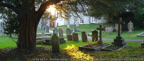
StinsfordStinsford is described in the Conservation Area Appraisal as a small, nucleated settlement. It is recorded in the Domesday book as being two parcels: Stitsford and Stincteford. It is centred around Stinsford Manor House (Grade II Listed), a large gentry house built in a long succession of rooms, facing south over small walled gardens and with two north-south wings. It was restored following a fire in the late 19th century. From 1963 to 1984 it was used as a school for boys, before being granted permission to convert it into a number privately owned apartments in 1997. To the west, on the far side of the Dorchester bypass, Eagle Lodge (unlisted) is the gate lodge to Stinsford House, thought to have been built together with the two stone piers originally with eagle finials in 1861. Both House and Lodge are considered to be the places mentioned in Hardy’s poem ‘The Widow Betrothed’. There are long-standing links between Stinsford Manor House (which was owned by Thomas Strangways, following his marriage to the estate’s heiress, Eleanor (Alianor) Talboys, in the late 15th century) and Melbury House at Evershot (which was acquired by his son) and later becoming part of the Ilchester Estate. The Honourable Mrs Charlotte Townshend, the current owner of Ilchester Estates, is patron of St Michael’s Church. The Church of St. Michael (Grade I Listed) is a pre-reformation church dating back to the 13th century, although elements such as the tower, south and north aisles were added in the 14th, 15th and 17th centuries, and further took place alterations in the 19th century. It features as the "Mellstock Church" in Thomas Hardy's novels, and his heart was buried in the churchyard in 1928. The churchyard is also home to the memorial slate of Cecil Day-Lewis, author and Poet Laureate, and a great admirer of Thomas Hardy. To the north east, built on glebe land in circa 1837, is the ‘The Old Vicarage’ (unlisted), a smaller gentry house.
Further south, Three Bears Cottage (unlisted), a much extended thatched cottage formerly referred to as Gardener’s Cottage, marks the southern limits of the village, and would have been passed frequently by the young Thomas Hardy on his daily walk to and from Dorchester. To the north side, Stinsford Farm House (Grade II Listed) was the former dairy house to Stinsford House and is now operated as a Business Centre. Birkin House (Grade II Listed) is further north still, and set slightly apart from the main village. This was built as a Victorian country house in 1874, for the banker Reginald Thornton. There are also four small blocks of cottages in its locality, including Stinsford Cottages (Grade II Listed) that face across a green towards the A35 London Road. |
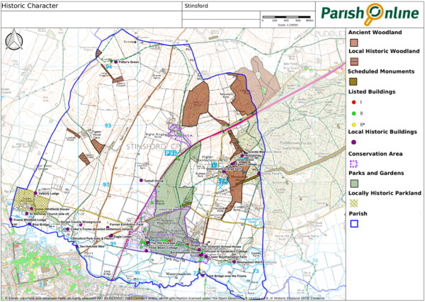
Figure 5. Local History Map

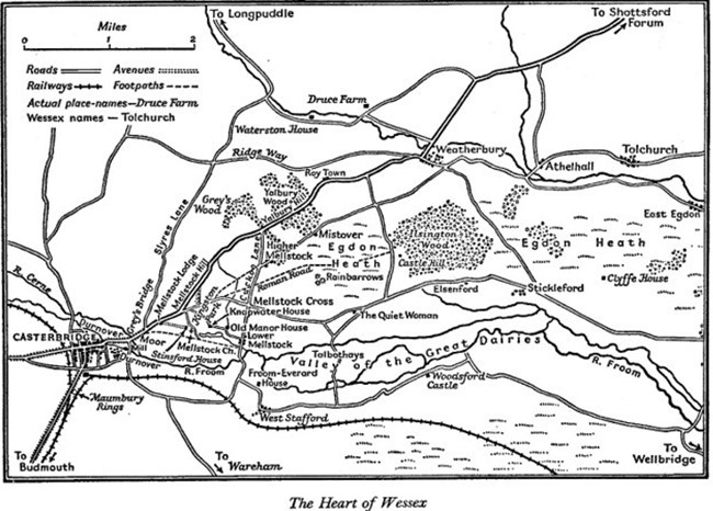
4.3 Hardy’s influence is not limited to the buildings listed in Table 5 – his books and his experiences span the wider landscapes in and around Stinsford (Hardy’s Mellstock). The richness by which Thomas Hardy observed and described the natural world in fine detail have helped us to identify some of the people and locations in his works, although others are still debated. Appendix 4 includes some of places associated with Hardy’s fictional characters who traversed the hamlets, paths, bridleways, tracks, and roads of ‘Mellstock’ during the 19th and early 20th centuries.
Figure 6. Hardy’s Mellstock (source: A Hardy Companion, FB Pinion)

Policy SNP7. Protecting Stinsford’s Historic Environment Development should preserve the significance of the many non-designated heritage assets and associations with Thomas Hardy (see Appendices 3 – 4 and Figure 5) and other designated and non-designated heritage assets, taking into account the balanced judgement required under national policy. Proposals which enhance or would lead to a better appreciation of these assets will be looked on favourably. |
4.4 With the strong Thomas Hardy connections, and the captivating, historic landscape, the area attracts more than its fair share of tourists. Tourism brings significant benefits to the local economy and residents, but it does have some ongoing negative impacts on the environment and character of the area, and on some communities, as a result of the increased visitor pressure and accompanying traffic (such as at Higher Bockhampton).
4.5 In light of this, any future tourism initiatives relating to the history and cultural associations, whilst welcome in principle, will need careful consideration to ensure that the environment and character of the area, and amenities of local residents, are not unduly harmed, and that there are robust measures in place to manage any traffic and visitor numbers appropriately. The Local Plan seeks to ensure that tourism development is located close to established settlements or re-uses existing buildings where practical, and while this approach is supported, it is recognized that Thomas Hardy’s associations are not limited to one area and that the infrastructure and environment in some settlements may not be able to cope with the levels of visitors that may come.
Visitor management plans… ✔ set out how visitor numbers and their impacts (e.g. traffic; parking; littering, trampling) will be monitored; |
4.6 In order to consider all these factors in a balanced manner, applicants are encouraged to include an assessment (ideally independently undertaken) of:
the economic and educational benefits that any new or expanded tourism proposals will bring;
the anticipated visitor numbers that the project is seeking to achieve (to achieve a viable business) and how those visitor numbers and traffic arising from the proposals will be managed, particularly with the aim of mitigating any adverse environmental and amenity impacts if visitor numbers were to exceed expectations.
Policy SNP8. Positively managing visitors and the Thomas Hardy connection The provision of any new facilities for tourists and visitors, whether related to the history and cultural associations with Thomas Hardy or to other attractions of the parish, must not detract from the parish's cultural, landscape and wildlife qualities or significantly impact on the amenity of local residents. In assessing the potential for harm to these qualities, consideration should be given to the cumulative impact of the development (in association with existing developments and attractions) as well as the direct and indirect impacts. Any new attractions or facilities should be located in close proximity to an established settlement or comprise the reuse or replacement of a rural building. Where visitor numbers and/or travel patterns will need to be restricted in order to avoid harm, such as in the neighbourhood of Higher Bockhampton, a visitor management plan will be required. |

< Previous | ^ Top | Next >