
Puddletown will look after the environment for today’s and future generations, protecting ecological habitats, providing adequate flood defences and avoiding harmful levels of noise from the A35. |
3.1.1 The local community places a very high value on the environment and ensuring that issues such as climate change and the loss of important wildlife habitats and species are taken fully into account in any and all planning decisions.
3.2.1 The River Frome runs along the southern border of the Plan area and has been designated as a Site of Special Scientific Interest (SSSI). It is a major chalk stream which supports rare and scarce aquatic invertebrates, various breeding riverside birds and a range of fish species.
3.2.2 Other locally important wildlife areas identified through the work of the Dorset Wildlife Trust include:
3.2.3 There are further areas of ancient and semi-natural woodland, deciduous woodland, wood-pasture and parkland located all over the Plan area, and grasslands associated with the floodplain of the River Piddle, just north of the village, which are also of potential ecological interest.
3.2.4 Thorncombe Wood Local Nature Reserve is located just outside the plan area to the south west (connected to Puddletown Forest). This site incorporates an area of around 25ha of deciduous and mixed woodland as well as open areas of bracken and fragments of heath.
3.2.5 Many of these areas support protected species, which may also be found elsewhere across the Plan area. For example, the chalk streams are an extremely important habitat for trout, salmon, eels, invertebrates, otters and water voles. Hedgerows and trees provide both roosting and foraging opportunities for a range of bird and bat species, and many rural barns and roof voids provide similar roosting opportunities. It is important that we consider and respect local wildlife in all of our actions, and take opportunities to improve and extend wildlife areas through appropriate planting and management.
3.2.6 The Dorset Environment Record Centre, working with the Dorset Local Nature Partnership, have mapped existing and potential wildlife areas across Dorset. Slow-worm, Common Lizard and Grass Snake have all been recorded as present in recent reptile surveys where there was grassland and scrub (but no sign of Great Crested Newts).
3.2.7 Dorset Council requires the submission of a certified Biodiversity Mitigation Plan in cases where the site size exceeds 0.1ha and on smaller sites where there could be important habitats or protected species present (for more details please refer to their validation process).
3.2.8 Even where development is unlikely to impact on existing wildlife, measures can
and should be taken to provide new habitats – such as the inclusion of bird, bat or bee boxes on buildings, creating a pond or other water feature in gardens, or even compost heaps and tree planting.
Map 4.
Puddletown's existing and potential wildlife areas
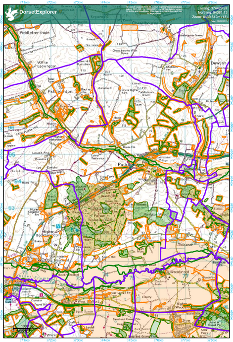
© Contains Ordnance Survey Data : Crown copyright and database right 2019,
© Crown copyright and database right. All rights reserved (100050773) 2019
Development should protect and, where practicable, enhance biodiversity, through an understanding of the wildlife interest that may be affected by development, together with an understanding of the likely impacts of climate change on these species and habitats,and the inclusion of measures that will protect the existing ecological network and secure an overall biodiversity gain.
Works that will support the ecological improvement of the network of existing and potential ecological sites, including their climate change resilience, will be supported.
3.2.9 Whilst there are no European designated sites within the parish, there are European designated sites in close proximity (including large areas of land to the east and south of the parish) which could be indirectly affected by development. This includes Poole Harbour (which the River Piddle flows into) and the Dorset heathlands between Bere Regis and Bovington, and at Warmwell and Winfrith.
3.2.10 Poole Harbour has been deteriorating due to the increased nitrogen levels from sewage and agricultural practices in the surrounding area that gradually make their way to the harbour. To ensure that any adverse impact on Poole Harbour is avoided, development will be required to demonstrate that it will include specific and appropriately located mitigation measures. These need to be implemented in a timely fashion in order to ensure that development is nutrient neutral from the start of its operational phase, and must continue for the duration of the development's effects. This could, for example, be achieved by securing additional agricultural land for land uses with a low nutrient status that would offset the anticipated increases in nitrogen from the development. Such land could also have the benefit of providing recreational and biodiversity benefits (eg community woodland, community orchards, a local nature reserve, new wetlands etc). A financial contribution to strategic mitigation measures may be an appropriate alternative to direct provision of mitigation. In this case it will be necessary to liaise with Dorset Council and Natural England to confirm an appropriate mitigation scheme to which the contributions will be directed and to ensure any contributions are sufficient to fully mitigate the impacts of the development on the Poole Harbour internationally designated sites.
3.2.11 Evidence has shown that residents living within 5km of protected heathland will tend to visit the heathland areas (unless other more attractive spaces are available nearby), leading to increased damage and wildlife disturbance. The accepted solution (set out in the Dorset Heathlands Planning Framework SPD) is to put in place measures to divert recreational pressure away from heathland. Only a small strip of land along the eastern boundary of the parish, and an area of land extending about 2km in from the southern extent of the parish, to either side of Ilsington Road, lies within 5km of protected heathland. As there is unlikely to be a significant amount of residential development within the 5km zone in the parish, it is unlikely that additional recreational land needs to be secured within the parish. However, if any new dwellings are built in this zone (for example, under the Local Plan policies that allow rural workers dwellings), a financial contribution secured through a S106 legal agreement towards a suitable project (which could potentially include improved access to Puddletown Forest) is likely to be the most appropriate solution.
Development must avoid having an adverse effect on the integrity of European and internationally important wildlife sites.
Project P3. The Puddletown Area Parish Council and Dorset Council will liaise with Natural England and the Forestry Commission to establish a potential project that would meet the Dorset Heathlands Planning Framework requirements.
3.3.1 Being built close to the River Piddle and its watermeadows, it is no surprise that significant areas of land close to the village are at risk of flooding, both when the river overflows (mainly affecting the watermeadows either side of the River, with the extent of flooding traditionally controlled by sluice gates), from rising groundwater levels (which is shown to cover the most extensive area but in reality fluctuates according to the season and recent rainfall rates) and from surface water flows (particularly off the surrounding higher land). The following map indicates those areas that may be at some risk from these sources. The Environment Agency updated its flood risk map for the Piddle Valley in 2019. Dorset Council also keeps records of flood risk from all sources and this too should be checked (and appropriate allowances made for climate change).
Map 5. Strategic Flood Risk Assessment map courtesy of Dorset Council12
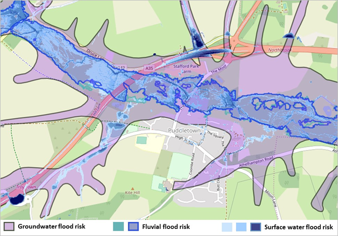
© Environment Agency © Open Street Map
3.3.2 It is unlikely that anyone would seriously consider developing on the watermeadows. In any event, both national planning policy and the Local Plan are clear that development should avoid the risk of flooding by steering development towards the areas at lowestrisk, and making sure that development does not exacerbate flooding elsewhere. On this basis, it is clear that any new housing in areas at medium or high risk of flooding would be refused.
3.3.3 As a result, the main flooding issue that is likely to crop up in considering new development (on land in and around the village outside of the watermeadows) is linked to the groundwater levels in the lower lying areas (which has implications for the use and design of soakaways and drainage systems) and the potential to reduce surface water flows that may be running through the site from higher land.
3.3.4 The River Piddle is classified by the Environment Agency as having ‘poor’ ecological status, therefore it would be a positive measure if any drainage solutions were designed in a manner which also enhanced its ecology.
3.3.5 Ongoing maintenance is also important - landowners are responsible for the maintenance of any waterways flowing through their land, drains and gullies should be kept clear of debris.
3.3.6 Any drainage plan, where required, should assess, and where feasible and appropriate, incorporate, opportunities to reduce the causes and impacts of flooding below current levels. This should include an assessment of the potential for soakaways and other measures to reduce surface water run-off and increase floodwater storage, taking into account the anticipated maximum groundwater levels and soil permeability. It should also set out measures to monitor and ensure the ongoing maintenance and management of the drainage system, and any remedial measures that may be necessary in the event of a systems failure, both on and off-site.
New development or intensification of existing uses should avoid flood risk from all sources and must incorporate a viable and deliverable drainage system to manage surface water runoff.
The future maintenance, upgrade or replacement of flood infrastructure must not be adversely affected by development. The design of any measures included in the drainage plan should take into account the desirability of improving the ecological status of the River Piddle.
3.4.1 Whilst Puddletown is a rural-based community, the background noise from the A35 main road clearly detracts from the area’s rural tranquillity.
3.4.2 Noise can become a nuisance when it results in a change of behaviour, and this can become significant when it may cause a material change in behaviour such as keeping windows closed for most of the time, or avoiding outside activities. At the highest extreme, noise can cause genuine health risks, for example through persistent sleep disturbance.
Map 6. Map showing areas where road noise may be a concern
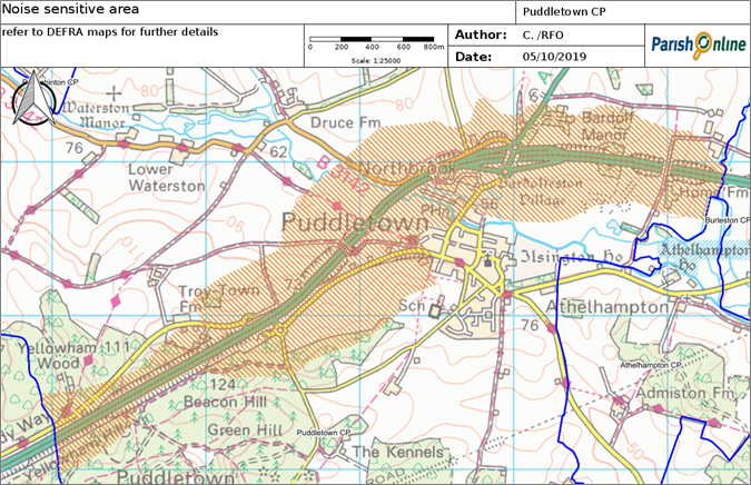
© Contains Ordnance Survey Data : Crown copyright and database right 2019, © Crown copyright and database right. All rights reserved (100050773) 2019
3.4.3 The latest (2018) World Health Organisation guidelines13 strongly recommends reducing average noise levels produced by road traffic to below 53 decibels (dB) Lden, as levels above this have been associated with adverse health effects. A lower limit of 45 decibels (dB) Lnight, is proposed for night-time road traffic noise to avoid adverse effects on sleep. Readings taken by the Department for Environment, Food and Rural Affairs (DEFRA) show that much of the land within 300m of the main road is impacted by noise levels in excess of 55 decibels (dB) during the day, and above 50 decibels (dB) at night, suggesting that this matter requires serious consideration in planning decisions. Map 6 indicates the approximate area within the parish where these noise levels may be experienced.
Noise is measured in decibels (dB) – using a logarithmic scale that reflects the sound pressure level. 0dB is the threshold of human hearing, 50dB is around the level of a normal conversation and 120-140dB is the threshold of pain. Lden (day-evening-night noise level) measure the noise across 24 hours but makes an adjustment for evening and night-time noise. Lnight covers the ‘night time’ period from 23:00-07:00 hours. The significant observed adverse level (SOAEL) is the level above which significant adverse effects on health and quality of life. |
3.4.4 The main reason the traffic on the road generates this level of noise is no doubt linked to the level of traffic on the A35 (which at the last count in 2017 was about 33,000 vehicles on an average day14) and the road surface treatment, which uses concrete in part. In the future a different re-surfacing could reduce noise levels, and the Parish Council will continue to press for this as and when opportunities arise through consultations.
Project P4. The Parish Council will continue to lobby for noise-reduction measures on the A35 as and when opportunities arise.
3.4.5 However, on the basis that the noise levels from the A35 remain at around their current levels, it is important that a noise assessment is undertaken at the planning application stage in relation to all proposals for residential and other ‘noise-sensitive’ developments that may be at risk from unacceptable noise levels. This should apply to all such development within the area shown on Map 6, which is based on the recorded noise level maps provided by DEFRA15.
3.4.6 The first step in any assessment is to have an accurate understanding of the current noise levels, as they may impact on development. Therefore any readings must be taken at different times of day and night and at the likely height and location of proposed buildings and windows (taking into account that noise levels may be different at upper floor levels if there is less intervening vegetation or other features that may help to muffle sound), as well as garden areas.
3.4.7 Whilst mitigation through design may well be possible, it is important that the measures agreed with the Local Planning Authority are likely to succeed (for example, it would be unreasonable to expect residents to keep their windows closed at night, so the internal layouts may need to ensure that at least one window faces away from the noise source), and do not themselves have adverse impacts (for example, a 3m high noise fence may detract from the local landscape character and may be hard to effectively screen). Highways England have advised that any structures must not be placed on, or require maintenance access to highway land relating to the Strategic Road Network.
3.4.8 A noise assessment will be required to accompany any application for residential or other noise-sensitive developments within the noise sensitive area identified on the Policies Map. The readings taken to inform the assessment must reflect the times and locations (and height above ground level) within the development from where noise from the A35 will be experienced. Mitigation measures must be included where necessary to reduce anticipated noise levels to within the recommended limits as set out in the WHO Environmental noise guidelines for the European Region (2018). Any such measures should not significantly limit the practical enjoyment of the building and its grounds, or have a significant adverse impact on local landscape character or the setting of heritage assets.
Policy 9. Noise Assessments
Noise sensitive development will not be permitted within the area shown as “where road noise may be a concern” on Map 6 without a noise assessment confirming that noise is either below the significant observed adverse effect level or can be mitigated through design or layout.
12 https://explorer.geowessex.com/sfra
13 https://apps.who.int/iris/handle/10665/279952
14 https://roadtraffic.dft.gov.uk/manualcountpoints/46381
15 https://www.gov.uk/government/publications/strategic-noise-mapping-2019
< Previous | ^ Top | Next >