
Puddletown will develop its housing stock, including the development of significant quantities of genuinely affordable housing for local people, at a pace commensurate with the desire to keep the village thriving. |
4.1.1 At the time of the last Census (2011) there were 614 households recorded, living in 663 residential properties, in the two parishes of Puddletown and Affpuddle. Between 2011 and 2019 a further 19 homes have been built.
4.1.2 There is no housing target or site allocations for Puddletown in the 2015 Local Plan. However the village does have a defined development boundary, and the Local Plan’s spatial strategy makes clear that “Development opportunities in the more rural areas will be focused primarily at the larger villages, and should take place at an appropriate scale to the size of the village (unless identified as a strategic allocation). It is expected that neighbourhood development plans and other appropriate planning tools will be used to help bring forward new development, and may allocate additional sites, or extend an existing (or add a new) development boundary to help deliver this growth.”
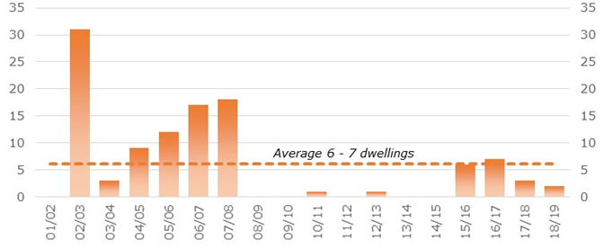
4.1.3 The consultations underpinning this Neighbourhood Plan indicated many residents felt that phased, modest and appropriate development should enhance the village and help maintain its services and vitality. The majority felt that the previous rate of growth (looking back over the last 15 or so years) would be reasonable, but a higher level may not. Based on available housing completions data (dating back to 2001) the general rate of growth has averaged at around 6 to 7 dwellings per year, with some years having significantly more and periods of very little development. This averaged growth rate is broadly equivalent to the proportionate share of the latest Government 2014-based household projections going forward.
Figure 8. Housing completions by year since 2001
4.1.4 A Housing Needs Assessment16 was also commissioned as part of the evidence base for the plan and completed in May 2018. This considered a wide range of factors, including various household projections, likely changes in the population demographic, house sales and prices (including known demand for affordable housing), access to employment and business workforce requirements, as well as past rates of development. The conclusion from this study was that, whilst 7 dwellings a year would reflect a pro-rata level of growth taken from the calculation of housing need for West Dorset suggested by the Ministry for Housing, Communities and Local Government (MHCLG) (which is based on household projections and affordability factors), a slightly higher target of 10 dwellings a year would be appropriate, taking into account factors such as the need to boost housing to sustain economic growth and also the fact that the rate of development in Puddletown in recent years has been relatively low (at 2 dwellings per annum).
4.1.5 More recently in October 2018, the review of the Local Plan (preferred options) suggested a formula for calculating the housing targets for Neighbourhood Plan areas, which for areas such as Puddletown would be based on a minimum 5% growth in population over 20 years. This would indicate a much lower housing need target for Puddletown, of around 2 dwellings a year. However this target may change given the decision in June 2019 to now progress the Dorset Local Plan.
4.1.6 Taking all these factors into account, a housing target based on 7 dwellings per year would seem a sensible approach at this time. For the 12 year period from April 2019 – March 2031 this equates to 84 new dwellings in total. As of September 2019, there were 9 sites which had planning permission for a total of 62 houses (as set out in Table 6), which would count towards the supply, leaving a requirement to find land for about 22 more dwellings.
Table 6. Housing Land Supply (September 2019)
| Ref | Decision | Location | Description | Homes |
|---|---|---|---|---|
| 16/0258 | 07-Sep-16 | Coombe Barn, White Hill | Erect a pair of semi-detached agricultural workers dwellings | 2 |
| 17/0145 | 15-Mar-17 | The Paddock, Blandford Road | Erect 2 dwellings and associated garages and parking | 2 |
| 16/0758 | 24-May-17 | Land S of 17-27 High Street | Erect 7 dwellings | 7 |
| 17/1429 | 18-Sep-17 | Camelot House, Three Lanes End | Demolish existing sheds, erect 5 detached houses (2 affordable) | 5 |
| 18/2347 | 30-Nov-18 | Manor Buildings, Manor Farm, Waterston Lane | Outline planning application for a rural workers dwelling | 1 |
| 19/0227 | 06-Mar-19 | Northbrook Farm Units | Change of use of agricultural buildings to 2 houses | 2 |
| 18/1124 | 02-Apr-19 | Land NW of Three Lanes End | Erect 41 dwellings, public open space and associated works | 41 |
| 19/0475 | 01-May-19 | Barn at 15 The Moor | Change barn, stable and out-building to form a dwelling | 1 |
| 19/1303 | 12-Jul-19 | Land adj 2 Styles Lane | Demolish existing garage and outbuildings and erect a dwelling | 1 |
ALL |
|
|
|
62 |
4.1.7 In choosing the sites that we want to allocate in this Plan, we have not used the target of 84 dwellings as an absolute limit. We have taken into account Government Guidance17 that “A sustainable choice of sites to accommodate housing will provide flexibility if circumstances change, and allows plans to remain up to date over a longer time scale.” Land has therefore been allocated for up to 32 - 34 dwellings. Sites have also been allocated for community facilities (see Section 5). It is also likely that further windfall development may be allowed (for example through conversions).
4.1.8 This means that there is no requirement to release further greenfield sites for open market housing or a need to rely on significant levels of windfall development within the defined settlement boundary before this Plan is reviewed. Any new housing in the countryside should be limited to rural affordable housing exception sites (should the need arise), the conversion of rural buildings, and agricultural and other rural workers dwellings who need to be present on site for their business, in line with the policies in the Local Plan.
4.1.9 Adjustments have been made to the defined development boundary to include these sites (and exclude land that is to be protected from development, such as Local Green Spaces). Community facilities (such as the schools, the surgery and the pub) which are on the edge of the settlement have similarly been kept outside of the defined development boundary, as such uses do not have to be within the boundary and the land should not be considered to have “development value” (as this may inadvertently increase pressure for their use to be relocated). Much of the area in the vicinity on The Moor and Backwater which is within the flood plain has also been excluded from the defined development boundary, given the need to avoid development in areas at risk of flooding.
Policy 10. The scale and location of new housing development in Puddletown
Sufficient land is allocated in the Neighbourhood Plan, which should more than meet the projected housing need of about 7 dwellings per annum (averaged) over the plan period. The defined development boundary has been amended (and is as shown on the Policies Map).
Given the identified supply through extant planning consents and site allocations clearly exceeds the housing need requirement, the development of open market housing on alternative greenfield sites outside the defined development boundary, or infill development that does not accord with the other policies in this Neighbourhood Plan, will be restricted.
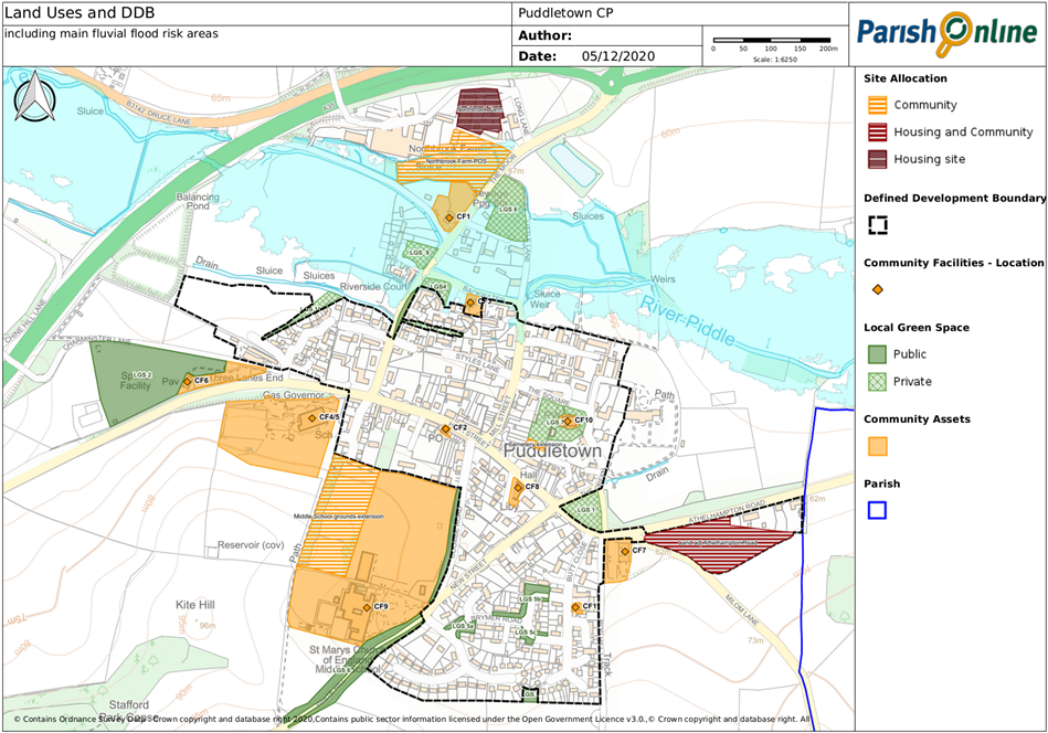
Map 7. Revised defined development boundary and site allocations
4.2.1 The Housing Needs Assessment also considered the type of housing which would be most appropriate to meet projected needs, concluding that:
What do we mean when we talk about ‘affordable housing’? Affordable housing is defined in national policy as “housing for sale or rent, for those whose needs are not met by the market (including housing that provides a subsidised route to home ownership and/or is for essential local workers)” and can include social rented housing (with rents linked to local wage levels), affordable rented housing (with rents set at least 20% below local markets rents), starter homes (for first time buyers, with an initial cap set on the sale price), discounted market sales (where the price is capped at least 20% below local house prices, and future sales similarly discounted) and other mechanisms such as shared equity. In Puddletown, our research has shown that some of these affordable housing options, if applied without further restrictions, are not likely to be genuinely affordable to local residents, because of the wide gap between local wage levels and market prices. So when we talk about affordable housing, we primarily mean focusing on social rented homes and larger discounts (than the nominal 20%) to ensure that the homes that are provided as affordable housing as genuinely affordable to local people. This should be set out clearly through planning conditions and/or a legally binding agreement. |
4.2.2 This very much aligns with local opinion expressed through the consultations that the main requirement is likely to be for small homes (both as affordable and on the open market). Smaller, affordable and low cost housing will attract young families to live here, and will also suit existing residents looking to get onto the housing ladder or who have limited incomes; some larger family sized homes will mean that growing families can remain in the area, and homes suitable for retired people to downsize to will ensure that older residents can move into housing that is more suited to their time of life.
4.2.3 It is also important that certain controls are put in place to ensure that, as far as possible, the housing that is built addresses the local needs arising from the parish and surrounding rural areas. This reflects both the Local Plan strategy (which aims to focus development at the towns, but recognises that sites may be needed elsewhere to meet local needs) and the wishes of the local community. This can be achieved through placing planning conditions or obligations on any affordable housing provision to ensure that available units are offered to people with a local connection in the first instance. Consideration was also given to whether a restriction on second homes would be appropriate, but given the economic benefits from tourism and relatively low level of second home ownership at present, this has not been taken forward.
It is important that developments will be viable to deliver, and this will depend in part on the mix of homes proposed and also the land values and costs associated with the development. Whilst viability evidence for the Moreton area (submitted as part of the Purbeck Local Plan examination in 2019) suggests that a 40% affordable housing contribution should be viable, 35% is considered reasonable in the Puddletown area to enable more social rented homes to be delivered. Where an applicant considers there are significant economic viability or site constraints that would prevent a mix of housing in accordance with the policy, they should present evidence to clearly demonstrate this as part of their application submission. In such circumstances developers are encouraged to enter into early discussions with the Local Planning Authority to explore alternative options that will still deliver genuinely affordable homes for the Puddletown Neighbourhood Plan area.
What do we mean when we talk about ‘local people’ and a ‘local connection’? 'Local people' are those who have a local connection. 'Local connection' is a person satisfies the local connection criteria of the Dorset Housing Allocations Policy. The criteria shall be applied firstly to those with a connection to the parishes of the Puddletown Area Parish Council (PAPC). The local connection criteria may be extended to the adjoining parishes of Charminster, Cheselbourne, Dewlish, Piddlehinton, Stinsford, Tincleton, West Stafford, West Knighton and Woodsford if there are no people with a local connection to the parishes of the PAPC, and then to the rest of the Dorset Council area. |
Policy 11. House types
The type and size of housing permitted should provide:
As a result, on sites that can accommodate two or more dwellings, larger homes (with capacity for 4 or more bedrooms) should be limited to no more than a single unit (or not exceed 20% of the open market mix on sites of five or more homes).
The mix of house types may be varied if there is clear evidence that site specific constraints or viability would otherwise prohibit development. Any change to the mix should demonstrate how genuinely affordable homes for the Puddletown Neighbourhood Plan area have been maximised as far as possible.
Where affordable housing is provided, this should be made on the basis of meeting the needs of local people and should be subject to a suitably worded condition or legal agreement to ensure that the housing will remain affordable for local people.
4.3.1 During the development of the Neighbourhood Plan, landowners were asked to come forward if they wished sites to be considered for possible new development. Independent planning consultants AECOM were commissioned to produce a site assessment report of the eight potential sites identified through this process and additional desk-top checks. From this, five of the sites were considered to have potential. The main findings of the independent site assessment are reproduced in Appendix 5. One of those sites (Site 6 at Lanes End) has since been granted full planning permission for 41 dwellings, and has therefore become part of the existing supply.
4.3.2 Those sites considered to “have potential” were then assessed further, taking into account the Plan’s objectives and the environmental objectives identified through Strategic Environmental Assessment. Given the land requirement was for about 22 more dwellings, the land area required could be as little as 1ha (based on the typical densities found across the village and housing need of smaller dwelling types). The results are summarised in Appendix 6.
4.3.3 The different pro’s and con’s between the site options means that there is no clear ‘front runner’ and the choice of site allocations considered carefully all the factors and
issues identified.
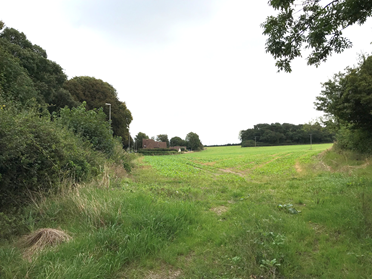
4.3.4 Part of the land at Athelhampton Road (Site 1) adjoining Chapel Ground was felt to be the most suitable greenfield site (compared to Pastures Field, where the access issues may prove difficult and impact on the site’s viability, and land off Rod Hill Lane, which if accommodating the same amount of dwellings would be likely to extend further upslope towards the ridgeline and have a greater adverse impact on the area’s rural character).
4.3.5 The development of this site also provides an opportunity to develop a community facility. The landowner has made clear that they will transfer an area of land adjoining the junction with Milom Lane to the community (either the Parish Council or a suitable community trust) to enable the provision of a new community facility (the exact nature to be agreed through further consultation), prior to commencing development. This area could lend itself to a ‘landmark’ type building or alternatively be landscaped as an open space. The area will extend to at least 0.2ha to enable sufficient parking provision to be included if needed, with the southern and eastern boundaries determined through more detailed design work required for a planning application. The landowner has also indicated a willingness to provide off-site provision of allotment space, for which there is a known need and may well also be used by the occupants of this development (although alternative recreation uses may be considered if a more pressing recreational need is identified). Previous research undertaken by the Local Planning Authority suggests that 600m² is the minimum practical size for an area of allotments, and that allotments should be within easy walking distance (1km). This would allow a range of allotment plots from small 10m² ‘starter’ plots for those who are new to allotment gardening, as well as including a number of half-size plots (125m²) that would be more suitable for an experienced gardener. A water supply will be needed.
4.3.6 The area required for housing does not have to be excessive to deliver the amount of new homes needed within the plan period (up to 22 dwellings), and therefore the allocated area has been kept to the low-lying land to the north of the line of telegraph poles that cross the field, and broadly within the 64m – 65m contour lines (after which the land begins to rise more steeply). Because this site will be viewed as part of the setting of the Conservation Area and the locally important Old School House (and potentially also relating to the Grade II* Ilsington Manor on the opposite of Athelhampton Road, should the existing tree screen diminish over time) the design and layout will need to be appropriate to this historic context. Particular points to note are:
4.3.7 Other factors will need to be considered as part of the design and layout. This includes:
Policy 12. Housing & Community Uses site allocation: Land at Athelhampton Rd
Land at Athelhampton Road, as shown on the Policies Map, is allocated as a site for housing for about 18 - 22 dwellings, and community uses. The development of this site will be subject to all of the following requirements:
a) The type and size of dwellings accords with Policy 11, with at least 35% of the homes provided as genuinely affordable dwellings.
b) An area within the site of at least 0.2ha, located at the junction of Athelhampton Road and Milom Lane, is made available for community use, with the transfer of land to an appropriate community body completed prior to the occupation of the first dwelling. Any building within this area would need to respect the potential inter-relationship with the Grade II* Ilsington Manor to the north, and the surgery building to the west.
c) Vehicular access will be provided directly off Athelhampton Road, with the junction designed to create adequate visibility to allow safe access / egress and to help slow traffic entering the village. An off-road east-west link for the Tolpuddle Martyrs Trail should be incorporated within the layout, and financial contributions will be required to improve pedestrian / cycle links into the village, to the satisfaction of the Highway Authority and in line with the aspirations set out in Policy 15.
d) A drainage plan is secured to manage groundwater and surface water disposal from the site to the satisfaction of the Lead Local Flood Authority, in accordance with Policy 8.
e) A combined landscape strategy and biodiversity mitigation and enhancement plan is agreed with the Local Planning Authority, in accordance with Policies 2, 3, 6 and 7, that
f) The scale, design and layout of the buildings should respect the character of the village as set out in Policies 3 to 5 and the setting of the Conservation Area, in particular taking into account the prominent nature of this site as viewed from the Athelhampton Road, and
g) An area of land of at least 600m² is provided for allotments (or for an alternative recreational use in agreement with the Parish Council) in a suitable location within easy walking distance (1km) of the site.
h) Any net new residential development will need to avoid giving rise to any adverse impacts on the integrity of Poole Harbour (a European site);
i) A comprehensive heritage strategy is agreed with the Local Planning Authority, in accordance with Policy 4, that:
4.3.8 Ultimately, the opportunity to develop underused farm buildings (at Northbrook Farm – part of Site 8) was considered to tip the balance in favour of its development, despite its distance from the centre of the village. The development of this site also provides an opportunity to provide public open space in this part of the village, which can be designed to help provide a safer pedestrian / cycle link into the village. The landowner has made it clear that they will arrange for the transfer of the area land between the site and Druce Lane to the community (either the Parish Council or a suitable community trust) as part of the site’s development.
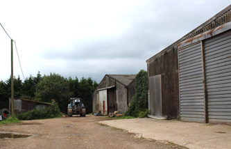
4.3.9 The Conservation Officer has advised that the remaining elements of the Threshing Barn within the site is of historic interest (this has been added to the list in Table 3, but may, subject to further research, be considered Listed as part of the curtilage of Stafford Park Farm House). The Stables (which are outside of the proposed allocation, and were granted prior approval for conversion to 2 dwellings in 2019) are of similar historic interest. The 1901 Ordnance Survey map shows these as being in existence at the turn of the 20th century, when the Threshing Barn was part of a larger courtyard complex which formed the western boundary of the walled garden to the farmhouse. Taking into account the historic layout of the site, and discussions with the Conservation Officer, a potential layout could potentially comprise:
4.3.10 Parking would need to be carefully considered, and may need to be an integral part of the buildings (such as attached car barns).
4.3.11 The other key issue for this site is its proximity to the A35 (and therefore the potential noise levels). Provided that the noise levels can be adequately mitigated without the need to encroach onto highway land relating to the Strategic Road Network, and an appropriate layout devised to respect the historic interest of the site and its relationship to Stafford Park Farm, the site should be able to deliver about 8 - 10 dwellings, in addition to the two dwellings already approved through the conversion of the Stables at the entrance to the site. The provision of some affordable housing on this site is important given the local housing needs (and at over 0.5ha the site would be considered ‘major’ development), although it is accepted that some flexibility may be needed if this impacts on the scheme’s viability.
4.3.12 Highways England will also need to be consulted on any detailed proposals this close to their highway land, including suggested site drainage arrangements (as any run-off should not connect into their highway drainage system).
Policy 13. Housing allocation: Northbrook Farm
Land at Northbrook Farm, as shown on the Policies Map, is allocated for housing, including some affordable homes, with public open space connecting to Druce Lane to the south. Its development will be subject to all of the following requirements:
a) A bat and barn owl survey is undertaken of the existing buildings and measures secured to ensure that there is a net gain in their habitat, and mitigation secured in accordance with Policies 6 and 7.
b) A noise assessment is undertaken and a mitigation strategy agreed with the Local Planning Authority in consultation with Highways England, and in accordance with Policy 9.
c) A drainage plan is secured to manage groundwater and surface water disposal from the site without discharge to the A35 highway drainage system, and in accordance with Policy 8.
d) The Threshing Barn is retained (and sympathetically converted) and its unsympathetic extensions and large modern agricultural buildings removed, and measures are taken to ensure that any evidence of potential contamination before or during construction are investigated and remediation agreed by the Local Planning Authority.
e) The area of land to the south (and as shown on the Policies Map) is provided as public open space, a management plan secured to increase its biodiversity value, and an all-weather off-road pedestrian access is created across this open space to link to Druce Lane, prior to the occupation of the first dwelling.
f) The type and size of dwellings accords with Policy 11, with at least 35% of the homes provided as genuinely affordable dwellings.
g) The site’s layout and detailed design is heritage-led, accords with Policies 2 to 5, and is subsidiary to, and respects the setting of, Stafford Park Farm (a Grade II Listed Building) the historic Stable block (to the south) and Threshing Barn.
h) Any net new residential development will need to avoid giving rise to any adverse impacts on the integrity of Poole Harbour (a European site);
i) A comprehensive heritage strategy is agreed with the Local Planning Authority, in accordance with Policy 4, that:
16 Produced in May 2018 by independent consultants AECOM for the Parish Council - http://puddletown-ndp.moonfruit.com/download/i/mark_dl/u/4013567449/4634573932/Puddletown%20HNA%20Final[83472].pdf
17 NPPG Paragraph: 103 Reference ID: 41-103-20190509 https://www.gov.uk/guidance/neighbourhood-planning--2#evidence-to-support-a-neighbourhood-plan
< Previous | ^ Top | Next >