
1.1.1 Puddletown is a village and associated civil parish in Dorset, England, with a population of about 1,400 residents1. Its local services, such as the shop and schools, are also used by people in the surrounding parishes, and Puddletown is part of a group Parish Council (with Athelhampton, Burleston and Tolpuddle).
1.1.2 The village is located at an historic junction of two main routes, the former A35 Dorchester to Bere Regis road (now bypassed to the north) and the A354 Blandford road, and lies to the south of the River Piddle, from which it derives its name. It is about 5 miles northeast of the county town Dorchester, with the larger Poole / Bournemouth conurbation about 15 miles to the east and Blandford Forum about 10 miles to the north–east.
Map 1 The Parish of Puddletown – the designated Neighbourhood Plan area
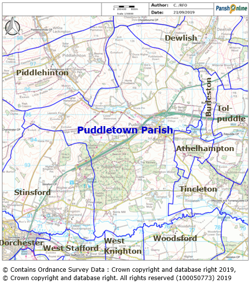
1.1.3 The civil parish is bisected by the River Piddle and the A35, extending about 1½ miles to the north, up to the chalk watershed of Puddletown Down, and 2 miles to the south to the flood plain and watermeadows of the River Frome. It includes the majority of Puddletown Forest to the west, and comes to the edge of Athelhampton House to the east. In total it covers 7,185 acres.
1.1.4 Puddletown is a distinctive and exceptional village and parish. Local residents not only appreciate the natural and environmental qualities of the village, but consider they have a duty to protect them for future generations who choose to live in, work in and visit the area. They consider there is a real sense of community, and want to keep and, if possible, improve the range of community facilities such as the schools, doctors surgery, village hall and library, vets, the local village shop / post office and the local pub. People also recognise that local businesses are important to the village economy. They want to support those existing businesses whilst attracting new enterprises, providing they are in keeping with the special qualities of the area. Importantly, people see the need for modest growth in housing, provided it is controlled, designs are in keeping with the character of existing village buildings, so that the sustainability of the village is enhanced.
1.1.5 A Neighbourhood Plan can be used by communities like Puddletown to develop a shared vision and to shape the development and growth of their local area. It provides us with the tools to choose where we want new homes and other buildings, what those new buildings should look like and what infrastructure should be provided. This will mean
that, when landowners apply for planning permission for new buildings, or to make changes to existing buildings and land, their plans are more likely to get approved if they meet the requirements set out in this Neighbourhood Plan (and more likely to be refused if they do not).

POLICIES = the basis on which planning applications, submitted by landowners and developers, will be judged by Dorset Council (as the Local Planning Authority). The supporting text to these provides further guidance as to why and how they should be applied. |
1.1.6 Without a Neighbourhood Plan, planning decisions will be based on the wider Local Plan for the area. At the time of writing, this was the West Dorset, Weymouth & Portland Local Plan 20152. The Local Plan includes general policies for settlements like Puddletown, allowing infill development to take place within the village and some types of development to take place adjoining the settlement and in the wider countryside, but has not specifically allocated new sites for development. However, the Neighbourhood Plan (which sits alongside the Local Plan) can provide more certainty over what is needed and what isn’t, taking into account the views of the community and our more detailed knowledge of this area.
1.1.7 This Neighbourhood Plan reflects the many issues and aspirations highlighted by those who contributed to the survey, discussions and meetings. The consultation effort in preparing the plan has been considerable and, while in general conformity with the principles of the adopted Local Plan, the Puddletown Neighbourhood Plan ensures that the views of people living in Puddletown have a legal status in the planning process, as intended by the Localism Act 2011.
1.1.8 There is an emphasis in the Plan on building and development. However impacts on transport, commerce, the environment and the underlying infrastructure of amenities and society in the village and wider parish have been considered, and wider aspirations and goals for local improvements noted.
“Should” is used in a number of policies and phrases in this plan – but this doesn’t mean the policy is optional. The word “should” in this plan means that it is expected that the policy is followed, and that very exceptional circumstances would need to be justified for it to be over–ruled. |
1.1.9 There has been considerable research and consultation underpinning this plan. Work started in 2015, and included household surveys, a housing needs assessment, site assessments, a three day design forum in the Village Hall, together with other events that addressed over 500 people. All of the policies and projects in the Plan have been derived from this research. Various environmental checks have been undertaken to comply with the legal requirements.More details of the related reports produced to support this plan are provided in Appendix 3.
1.1.10 The Plan has to align with overarching principles and the strategy for development that are in the Local Plan for the area. A wide range of statutory consultees, including Natural England, Historic England, the Environment Agency and Dorset Council reviewed the plan at its pre–submission consultation stage. It was also tested by an Independent Examiner, who had to decide whether it met the basic conditions that are set out in the Neighbourhood Plan legislation (and if not, what changes were necessary). The final decision, on whether Dorset Council (as the Local Planning Authority) should use the Plan, is voted on by local residents in a referendum.
The plan was prepared by the Neighbourhood Plan Group, which in 2019 comprised Peter Churchill, Jane Cox, Janey Gordon, Janet Ranger–Dennis and John Ridout, with the support of Anna Bendall (Parish Clerk) and Jo Witherden (Dorset Planning Consultant Limited). Thanks also go to all the contributors who helped in the earlier stages, including Paul Langdon who led the Steering Group during 2017 – 2019, all other former Steering Group members, and Richard Eastham (Feria Urbanism) who provided consultancy support. |
1.1.11 Planning does not stand still, and we will need to consider reviewing this Plan before too long whatever timeframe it covers. Dorset Council has committed to preparing a new Dorset Local Plan, which is expected to replace the adopted Local Plan for West Dorset, Weymouth and Portland by 2023. When the new Local Plan is in place, some of the policies in this Neighbourhood Plan could become out of date, so it will make sense to consider what aspects should be updated at that time. A review will also provide an opportunity to reflect on which policies are working well, and which could be improved upon.
1.1.12 So this Plan covers the period from 2019 (when it was drafted) to 2031. Whilst it was initially thought that it would run to 2036 (which was the provisional date for the Local Plan Review), it now makes sense for it to cover a slightly shorter period to 2031 (in line with the adopted Local Plan), anticipating that it will be reviewed and potentially rolled forward by 2026.
2019 – 2031
1.1.13 Monitoring (such as how much and what mix of housing is being achieved) will also help to ensure that the need to review the Plan is kept under consideration. The following factors will be monitored by the Parish Council, working with Dorset Council, on an annual basis:
1.1.14 The decision to review the Plan will need to be made by the Parish Council (as the responsible body), with local residents involved in the review process, as they have been with the drafting of this Plan.
| "The concept of sustainable development can be interpreted in many different ways, but at its core is an approach to development that looks to balance different, and often competing, needs against an awareness of the environmental, social and economic limitations we face as a society."3 |
1.2.1 The vision and objectives that underpin this Plan were developed from public engagement at the meetings and consultations, and have taken into account the concept of sustainable development. To achieve sustainable development, a thoughtful and sensitive approach is required; one that meets identified and projected needs for housing and other uses, but in doing so does not needlessly damage the environment or undermine the social fabric and well–being of the village or wider parish.
| In 2031 Puddletown will be a safe, thriving, and well–connected village, maintaining its unique character and sense of community spirit, and welcoming residents of all ages and abilities. |
Puddletown will...
1.2.2 The planning policies contained in this Plan are intended to achieve these objectives – so these objectives should be referred to when interpreting the policies if there is any doubt how they should be applied.
1 The Office for National Statistics estimated the combined population of Puddletown and Athelhampton parishes in 2017 as 1,492 https://apps.geowessex.com/stats/AreaProfiles/Parish/puddletown–and–athelhampton
3 This definition was proposed by the Sustainable Development Commission (SDC) which was the UK Government's independent adviser on sustainable development up to 2011 – http://www.sd–commission.org.uk/pages/what–is–sustainable–development.html
< Previous | ^ Top | Next >