
The Neighbourhood Plan’s Vision and Objectives have been distilled from the results of the Parish Survey (81% of households responded) and subsequent consultations reflecting the sentiments of the Parish Community. The key issues and themes emerging from consultation sought to maintain and enhance the rural character of the Parish; protect the countryside, its landscape character and the historic nature and appearance of its settlements; safeguard the vitality of the parish community, its village amenities and its continuance as a working community; facilitate incremental residential development as has occurred in the past with a focus on infill development to provide smaller homes to meet the wishes of the local community. There was some limited support for new small business development with no active encouragement to small industrial workshops or further tourism. [Source: Village Survey Findings].
Loders Parish is a thriving rural community with a wide range of activities for young and old. We also like living here because it is an attractive historic settlement set in beautiful unspoilt countryside. Over the next 10 to 15 years some building and change can be expected, to retain a good mix of housing, business and community uses. This should be organic and incremental so that any development and change is indiscernible, as building works will be in keeping with the historic character of the settlement, and unobtrusive in the wider countryside.
As set out in the Overview (Section 2) above, the special qualities
of the neighbourhood plan area, its historic settlements and outstanding
landscape is of crucial importance to the parish residents. The
response to the Loders Parish Survey reflected views and aspirations
similar to those in the Loders Village Design Statement (LVDS 2000 updated
2014) and the detailed guidance provided in the Conservation Area Appraisal
for Loders & Uploders (WDDC 2007).
The Village Design Statement (LVDS) and Conservation Area Appraisal (CAA) place emphasis on the significant green open spaces, both within and between the principal settlement areas of Loders, Yondover, Uploders and Matravers. These undeveloped green spaces must be protected from development as they capture the character of the village and are important to its special character, setting and views in and out of the individual settlement areas. Within these areas infilling has been resisted.
The National Planning Policy Framework (NPPF 2012) places emphasis on, amongst other things, the achievement of sustainable development, protecting the countryside, promoting healthy communities and conserving heritage assets. These provide an important context to the LNP policies below. Similarly the emerging West Dorset, Weymouth & Portland Local Plan (due to be adopted early 2015) is based on the principle of sustainable development and the strategic approach is to protect the environment whilst concentrating development in larger settlements where there are existing services and transport alternatives to use of the private car.
We place a high value on the special features of the countryside and buildings in the neighbourhood plan area. We want to make sure these remain for future generations to enjoy. This means careful stewardship of the farmland, hedgerows, trees, rivers and open amenity areas; protecting our wildlife habitats and the features in the landscape we value such as the strip lynchets and old trackways. We also want to make sure that the traditional form and style of buildings in the parish is kept and that any new building respects this.
Important Gaps, Views and Local Green Spaces
Green areas surrounding and within the village, are essential to the
rural character of the area. The open gaps between the main areas
of settlement make sure that one settlement does not ‘run into’
the next, but each retain their own identity.
The linear layout of the village, punctuated by open spaces, was identified
in the original Loders Village Design Statement as one of its most precious
features. These open spaces connect the community with the landscape
beyond. “These green spaces are an essential feature…separating
the elements of the village – but also help unite them as a distinctive
whole. It is the existence of these open spaces which residents placed
at the top of their list of 20 Themes that capture the character of
Loders.” The Conservation Area Appraisal also recognises
a number of these key rural views as adding to the character and enjoyment
of the area. Sometimes these comprise ‘glimpses’ of
the setting (and prominent hilltops) between buildings, and other times
more extensive views of the river corridor, meadows, strip lynchets
and surrounding hills. Finally, there are a number of distinct,
discrete, green spaces that are particularly cherished for their local
identity and the contribution they make to the history or character
of the area. Even if their ownership or function were to change,
their importance as a local green space would remain. These areas
are designated as local green spaces and this designation should continue
beyond the period of this neighbourhood plan.
The important gaps, open views and green spaces are listed in the following tables and shown in Map 4. Consideration was also given to the protection of the river corridor and strip lynchets as important green spaces, but their size rule them out as potential local green spaces. Both are of particular importance to the definition of the linear quality and setting of the village. They are protected in their own right as an important feature in the landscape under Policy E2.
Important open gaps
Important rural views
Important local green spaces |
Reason for their designation |
The parkland at Loders Court from the Churchyard to Loders Mill |
The monastic parkland between Loders Mill and Loders Court / St Mary Magdalen’s Church, which can be glimpsed from the main road, provides an important setting to the key historic buildings, and a definite ‘stop’ or gateway at the western entrance to Loders. |
Boarsbarrow Hill |
The woodland located on top of Boarsbarrow Hill is a key feature in many views, and therefore an important local landmark. It is also an area which is rich in wildlife and includes a number of possible historic barrows. |
Waddon Hill |
The upper slopes of Waddon Hill, with their mix of woodland and strip lynchets, provide a backdrop to the settlement of Loders, and the woodland is also rich in wildlife. |
The cemetery (including the allotments) at Highacres |
The land has been consecrated providing a local cemetery dating back to the 1930s and will continue to provide cemetery space for generations to come. |
Wooded area to the north of houses on Highacres |
The wooded area lying adjacent to the cemetery is important in views from open farmland between Yondover and Shatcombe; provides a wooded backdrop/screening to the housing at Highacres and is important to the biodiversity of the area. |
Playing field adjoining Wellplot |
This rather boggy area running down to the river is important because not only because it has been used for recreation by local residents over many years, but also because of its link to the river and views it provides from within the Conservation Area |
Croads Farm |
This is an important green “break” created by Croads Farm on both sides of the road in the otherwise linear development of Uploders, of historic and character value. |
Map 4: Important Gaps, Rural Views and Local Green Spaces (Inset Map 4A and Inset Map 4B can be found at end of this document)
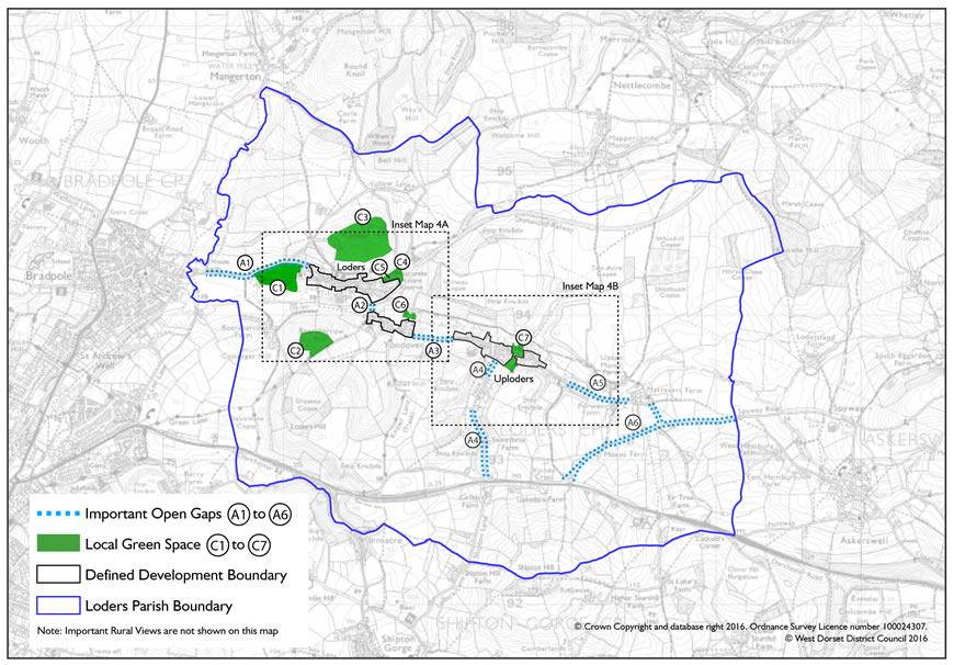
The landscape character of the area, the important gaps between built up areas, the rural views and local green spaces are given the highest priority in accordance with adopted Local Plan policy ENV1. Accordingly, development will be supported where it does not undermine the important landscape character of the area in particular where:
A. The gaps along the road fronts between the built-up areas which are important in defining the distinctive character of each settlement, and the rural, non-built-up nature are conserved and enhanced. These gaps are identified on Map 4 and inset Maps 4a and 4b, and referred to as follows:
B Key rural views are respected and their enjoyment not infringed
upon. The key rural views are identified on Map 4 and Inset Maps
4a and 4b, and referenced as follows:
C. Local green spaces identified as of particular local importance are protected, to the extent that no development will be permitted within them that would harm their green character and reason for designation. The Local Green Spaces are identified on Map 4 and Inset Maps 4a and 4b, and referenced as follows:
A number of features in the wider area are considered to be particularly
important in defining the special character of the area, and these features
and their settings need to be properly considered when development is
planned. Many of these have been identified in the Conservation
Area Appraisal or the Landscape Character Assessment of this part of
the Dorset Area of Outstanding Natural Beauty, and there is a duty on
the planning authority to protect and enhance the special character
of this area. Most can be seen from wider viewpoints, including
the local network of bridleways, trackways and footpaths.
For example, landscape features including deep sandstone cuttings,
extensive green 'tunnels' and open views to prominent 'sculptured' hills.
There are distinctive ancient iron age forts and barrows atop of surrounding
hills, medieval strip lynchets and the river valley. In all these
cases the adjoining fields provide a rural, unspoilt setting.
There are also ancient humped road bridges, disused railway line and
winding narrow country lanes and tracks, all of which combine to provide
an important context to the historic settlements.
The absence of modern design elements, such as street lighting, concrete kerbs and pavement, is considered to contribute to the traditional rural character of the area. The proliferation of poles and wires above ground has been noted in the Conservation Area appraisal as a detrimental feature.
Development will be supported where the following features and their settings are retained:
The benefits of removing detrimental features, such as modern out-of-character design elements and overhead wires, will be taken into account in assessing any development proposals.
The area has many different wildlife and plant species, encouraged
by the diverse environments such as springs & watercourses, trees
following river valleys, steep open grazed slopes, extensive hedgerows,
different soil types and distinct stands of trees. Although there
are only three designated nature conservation sites in the plan area,
it is important that consideration is given to the wider potential for
wildlife and this policy is intended to help identify where further
investigation may be appropriate.
Protected species recorded in the parish include many types of bat, farmland and woodland birds, moths, a range of mammals including river mammals (otters and water voles), important fish, (evidence of salmon and sea trout spawning sites), and different types of plant. The habitats that support these species include lowland calcareous (chalk) grassland, the arable field margins, deciduous woodlands, wet woodlands, river corridors and hedgerows. Even gardens can provide important habitats – for example compost heaps are used by slow worms, and redundant rural buildings and roof spaces make ideal roosts for bats and owls. The river corridor, hedgerows and arable margins are all important wildlife corridors, allowing animals to move through the area (for example, linking bat roosts to feeding areas).
As a matter of course the district council requires a biodiversity appraisal by a suitably qualified ecologist for all development on sites over 0.1ha in size, and for the conversion or demolition of rural barns / farm buildings and other derelict structures. However we would encourage developers to think about taking advice from a suitably qualified ecologist on sites below this threshold, where there is a reasonable possibility that there may be some biodiversity interest on or close to the site. This isn’t intended to slow down development, as early knowledge of potential nature conservation interests can ensure that development proposals include suitable avoidance or mitigation measures, rather than having to revise plans because a protected species is first noticed when construction is about to start.
Development proposals should, where relevant, take opportunities
to enhance biodiversity and contribute to wildlife and habitat
connectivity in the wider area, through (for example) providing
buffer areas to protected habitats and including new biodiversity
features within the development such as the erection of barn and
little owl/kestrel/bat and garden bird boxes in suitable locations.
On sites below the standard thresholds for a biodiversity appraisal,
applicants will submit (as a minimum) an initial scoping / feasibility
appraisal that identifies ecological aspects or considerations,
where the proposed development site includes or is adjoining
Design, including the scale and positioning of new buildings (and changes
to existing buildings), materials and detailing, is key to making sure
that development preserves and enhance the character, appearance and
integrity of the area.
Much of the parish lies within a designated Conservation Area and many
of the buildings/dwellings (46) in the main settlements are Listed as
buildings of special architectural or historic interest. Under
current Planning, Conservation Area and Listed Building legislation,
works - including demolition, alterations and extensions - to Listed
buildings and unlisted buildings in Conservation Areas are more tightly
controlled.
The character and appearance of the area and its intrinsic qualities
have been identified in the Loders Village Design Statement [LVDS] and
Conservation Area appraisals [Loders and Uploders, Powerstock and Nettlecombe
Conservation Area Appraisal 2007 p 10-20]. These have remained
largely unchanged. The preparation of the Neighbourhood Plan has
provided the opportunity to review this supplementary guidance and enhance
its status by including the main elements within the development plan
policy framework. The key characteristics of the settlements drawn
from the Conservation Appraisal and LVDS are set out below in LNP Policy
E4.
The overriding intention of this policy is to ensure a high quality of design and appearance that integrates and enhances the existing character of the settlements or outlying parts. The majority of buildings in Loders parish are historic; built during the eighteenth and nineteenth centuries by local craftsmen using local materials. This consistency underpins its special appearance, attractiveness and conservation area status. Unfortunately much of the twentieth century housing in the parish fails to achieve this quality of design and materials and spoils some local views. New development – including extensions and alterations to existing buildings –should therefore aim to enhance the character and appearance of Loders parish; achieve high quality and sustainable design; minimise water use to prevent unnecessary waste of water and achieve high standards of environmental performance.
New development must demonstrate how it responds to its context and the established character of the area in which it is located and take account of the Loders village design statement and Conservation Area appraisals.
Development proposals (including new buildings and extensions / alterations to existing buildings) will be supported where they are sympathetic with adjacent buildings and achieve a high quality of design, use of materials and appropriate detailing which reflect local distinctiveness and respects the rural character of Loders Parish. In considering whether proposals achieve this requirement, particular regard should be paid to:
and be of sustainable design and construction to minimise the impact of climate change, including the use of permeable surfaces to minimise surface water run-off and minimise water use.
New development should be located within or adjoining the existing
settlement pattern, where organic growth would have occurred historically,
and where the services and infrastructure already exist. Development
in the open countryside is not as accessible and often detracts from
the natural beauty and character of the area.
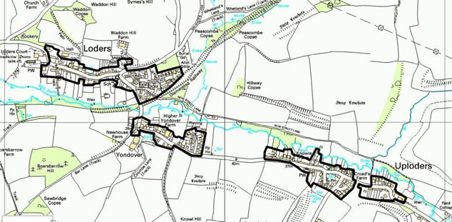
The local plan seeks to avoid isolated development in the countryside and protect the character of the area by identifying a ‘defined development boundary’ where development may be acceptable. The development boundary for Loders was removed when the 2006 Local Plan was adopted. As part of preparing this neighbourhood plan, a defined development boundary has been re-introduced for the main settlement area in the parish, as shown in Map 5.
Map 5: Defined Development Boundary
© Crown copyright and database rights 2015 Ordnance Survey 100050870.
All plans are required to promote development and have a degree of flexibility in terms of the future use of land, to accommodate needs and circumstances that may not have been anticipated when the plan was written. There will therefore be exceptions where development may be permitted outside a defined development boundary, and a number of these are listed and explained in the over-arching local plan and will still apply in this neighbourhood plan area. In the Loders Parish area the most likely ‘exception’ to occur outside the defined development boundary relates to the provision of affordable housing on what is known as ‘rural exception sites’, new business development (provided that this would be acceptable in all other regards), and community uses – such as a new village hall, play area or the like. Development necessary for the area’s farming community, and also the potential to reuse existing buildings, provide examples of other changes that may be appropriate outside the defined development boundary.
Development will be supported within the defined development
boundary that has been drawn around Loders and Uploders (see map
5). Any new buildings (other than for farming and other
land-based rural businesses, or associated rural workers’
housing) and associated land (such as gardens or parking areas)
should be located within this development boundary. In exceptional
circumstances new buildings may be allowed outside of this boundary,
and in these circumstances where the need for new buildings is
justified, they must be well-related to the village and sensitively
designed to respect and enhance the character of the local area.
The change of use of land to other forms of development such as caravan and camping sites, outdoor recreational or the provision of outdoor storage, that would have a noticeable detrimental impact on the attractive rural character of the countryside, will not be supported.
There are relatively few potentially redundant rural buildings in the neighbourhood plan area but when one does become available for development it should be re-used in order to maintain the vitality of the community, particularly where the building makes a positive contribution to the area in terms of its local character. Use of redundant rural buildings for housing (either open market housing or affordable housing), small businesses (including tourism accommodation), or community facilities such as a farm shop is therefore encouraged, if the character and location of the redundant building is suitable and appropriate. Development would not be supported if it would cause a negative impact (such as traffic problems, damage to hedgerows, noise and disturbance) on the rural character of the area or the living conditions of nearby residents.
Where a redundant rural building makes a positive contribution to the local character, and is not in an isolated location where substantial new infrastructure would be required, its re-use for housing, community or business use, where appropriate, will be supported.
Loders Parish has a very active community life with well used community
facilities in the main settlement of Loders and Uploders for a variety
of informal and organised activities.
Planning Policy at national and local level promotes healthy communities
and recognises the essential role of community facilities - including
schools, meeting places, public houses and places of worship - in enhancing
their sustainability. Access to high quality open spaces and playing
fields, protection and enhancement of public rights of way, access and
transport facilities is also recognised as underpinning the health of
the community.
We are proud of the fact that we have an active working community. Community activities flourish here, strongly supported by volunteers. It is important to us that these community facilities are kept and supported.
Past decades have seen a decline in a number of village services and
the last of the village shops which included a post office closed in
1991. To some extent this is inevitable as major retail supermarkets
appeared in and on the outskirts of Bridport making village shops unviable.
However in a rural community if the village is to survive as more than
just a dormitory settlement for surrounding towns, its community facilities
and amenities which underpin its vitality must be protected and enhanced
where the opportunity arises.
The provision of services such as the mobile library and the limited
local bus service are important to the Parish community and are provided
by other agencies. Similarly support to local businesses in the
way of improved broadband access and mobile phone signals lie outside
the ability of the neighbourhood plan to deliver, but the Parish Council
will do all it can to secure improved service.
The Parish Plan (2013) identified various projects that could further
add to the vitality and sustainability of the community:
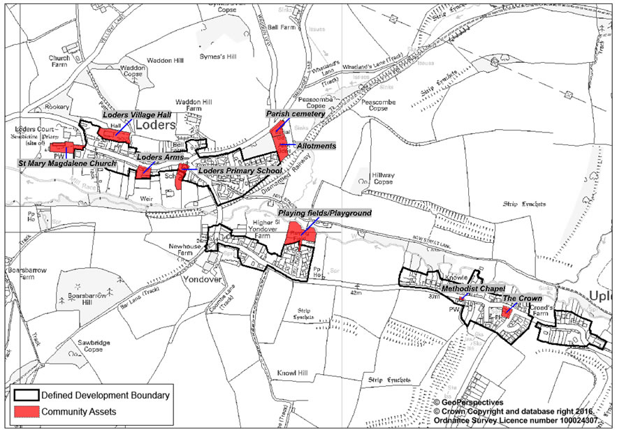
This policy is intended to ensure the protection of community assets which make an important contribution to the life and sustainability of the parish community and bring forward new facilities when the opportunity arises. The location of existing community assets is shown in Map 6.
Development proposals that encourage the retention of community assets, as listed below, will be supported and every effort should be made to work with the local community to investigate potential solutions to avoid any unnecessary loss of these valued facilities and services, and also to bring forward new assets such as a village shop. Proposals that would allow such facilities to modernise and adapt for future needs are encouraged.
Map 6: Existing Community Assets
The Parish Survey showed that the majority sentiment was for the community
to grow incrementally with support for a rate of housing growth of ‘up
to 10 houses’ over the plan period to 2027. The majority
view was in favour of small dwellings for small family homes, homes
for first time buyers and for people to downsize – preferably
as infill development. Smaller homes would also provide a more
balanced mix of available homes. Most people felt that the conversion
of redundant farm buildings for housing would be acceptable.
Affordable housing was felt to be the biggest need and information
from the Housing Register (December 2014) highlighted that there were
nine households on the housing register with a local connection.
The majority of these (7 households) require one or two bed homes, primarily
for affordable rent. Affordable housing can be provided as an
exception to normal development policies outside a defined development
boundary. Local residents would prefer such sites to be located
close to the village to benefit from and support community assets; to
be in small groups (preferably of two to three small dwellings of two
to three bedrooms), and that their design should be in accordance with
the design policies in this plan. When affordable homes are provided,
the landowner will be required to enter into a legal agreement to make
sure that these remain affordable in perpetuity, and that they are offered
to people with a local connection before they can be offered to others.
This legal agreement will apply to any subsequent landowners if the
land is sold.
As a community we want to remain much as we are - whilst allowing for organic and incremental growth of housing that broadly reflects the past rate of growth and addresses our local needs for housing in the plan period to 2027. We want to ensure that this new or additional housing is of high quality design, small in scale for small family homes, homes for first time buyers and people wishing to downsize, and preferably provided by infill development (but not infilling the gaps and local green spaces identified in this plan).
The parish is not an area that would be suitable for a significant
level of growth because of its rural nature. There are many constraints,
for example the historic features and their settings, flood risk areas,
wildlife and landscape designations. Furthermore, large estate
development would not be appropriate in character. And a significant
level of growth would exacerbate the problems currently experienced
on the rural roads, with more on-street parking and traffic movements.
However change can be positive, and the slow and piecemeal development
of villages is one of the characteristics of rural Dorset. In
the 2012 Loders Parish Survey the residents were asked their views on
how the area should develop. The majority felt that up to 10 dwellings
would be an appropriate level of growth over the next 15 years, which
is higher than recent years and closer to the rate of growth experienced
on average over the past 12 to 15 years.
In preparing the neighbourhood plan, studies were undertaken to examine
the potential for housing development in the village and in peripheral
areas of the parish. This showed that sufficient capacity existed
in the village within the area of the proposed development boundary
to meet residents’ aspirations for housing growth and accommodate
this number of dwellings, having regard to the potential for change
of use of, for example, redundant barns, holiday lettings and new infill
development. The type of infill development considered to be appropriate
was small-scale (i.e. one or two new homes) in an otherwise built-up
frontage, or set behind where this would be in keeping with local character
(for example, to look like a row of modest agricultural outbuildings
running at right-angles back from the lane / main building line).
Following consultation on options, the development boundary defined by LNP Policy E5 was agreed on the basis that there was potential for organic growth in keeping with the special historic and rural character and without overloading the infrastructure of the area. No specific sites have been identified in this plan, but the plan policies and development boundary are intended to facilitate the potential for new sites and opportunities to come forward.
Within the defined development boundary (DDB) new housing providing
in the region of 10 new homes over the plan period will be supported,
so long as the development is acceptable in all other respects.
Development of new housing within the development boundary should
be provided through
The 2011 Census shows that homes in the area tend to be larger than
average compared to West Dorset and England as a whole, with nearly
three out of four homes having three or more bedrooms. Not surprisingly
therefore, the results of the parish survey showed a preference for
small family dwellings including affordable homes for people with a
local connection.
In considering the appropriate type and size of housing provided, there is a strong preference for smaller family homes and homes for first time buyers, in order to provide a more balanced mix of available homes and assist in maintaining the vitality of this rural community.
New housing will be supported where the type and size of new
housing reflects the need for small homes of two or three bedrooms
suitable for couples and individuals looking to downsize or as
homes for first time buyers suitable for individuals, couples
and families, unless it is to provide for a known local affordable
housing need.
The substantial enlargement of existing homes through combination or extension into adjoining dwellings, potentially reducing the stock of more affordable, small scale homes, will not be supported.
The quality of development in terms of design is covered under policy E4
Whilst the defining nature of the area historically has been farming,
this is changing. Agriculture is switching from dairy farming
(now only one located in the village settlement) to the rearing of livestock
– pigs and cattle mainly but with some of the surrounding fields
also used for grazing sheep. This has resulted in the re-use of
some outbuildings and barns for other business use such as net making,
furniture making and novelty chinaware.
The results of the Parish Survey showed that nearly two thirds of the
residents were of working age with a significant number working in small
businesses locally or in surrounding villages. This includes farming,
local workshops/crafts and working from home including visitor/tourist
related activities such as bed and breakfasts, holiday lettings and
our two pubs. Local employment adds to the sustainability as well
as the economic health of the parish community.
However with many modern, larger businesses, including some tourist
operations, increased vehicle activity and size of vehicles (particularly
along narrow country lanes), noise and other disturbance is not compatible
with the objectives of conserving and enhancing the natural beauty and
history of the area.
Businesses flourish from many places in the parish including homes, workshops and redundant farm buildings. It is important to us that we stay an active working community. We want to support locally-based businesses, including those in the parish who work (or want to work) locally and/or from home. This may be through improvements to working conditions, communications and services where these can be influenced by the neighbourhood plan and also supporting extensions to existing business where these will not cause traffic problems or noise and disturbance.
Local employment initiatives are an important factor in maintaining the life and vitality of the parish. The intention of this policy is to support extensions to existing small businesses and the re-use of redundant agricultural buildings for business purposes. Some business uses such as tourist activities and attractions can seriously harm the rural character of the area (eg permanent camping and caravan sites, caravan storage and off road activities such as motor bike and 4x4 scrambling) and are not considered to be appropriate.
The sustainable growth and expansion of new or existing local businesses will be supported where there is no requirement for road or junction alterations which will harm the distinctive rural character or amenities of the area.
Support will be given to employment developments which can be clearly demonstrated as being unlikely to substantially increase vehicle activity or large lorry movements on the small country lanes (and taking into account the traffic issues such as those highlighted in the neighbourhood plan), harm the rural character of the area, or cause harm to the living conditions and amenities of residents.
Applications for change of use of redundant rural buildings or extensions to existing small businesses will be supported, subject to the above. Where existing buildings are modern or utilitarian in character (and do not make a positive contribution to local character), opportunities should be taken to improve the building’s appearance.
< Previous | ^ Top | Next >