
The key settlements within the Loders Neighbourhood Plan area (LNP)
are from west to east: Loders, Yondover, Uploders and Matravers and
also include the outlying hamlets of Vinney Cross and Loders Cross (including
Gribb Farm) which lie either side of the A35, and isolated farms surrounding
Shipton Hill (such as Innsacre Farm). The Plan area has a population
of 518 (2011 census).
The village settlements of Loders, Uploders and Matravers have developed
along the waterline of the River Asker, a small affluent of the River
Brit. They lie in the folds of the surrounding Powerstock Hills
which has promoted its linear characteristics. The underlying geology
and resultant topography have given the surrounding landscape its beautiful
and distinct character. A single lane village road runs along
the valley connecting the villages of Bradpole in the west and Askerswell
in the east, both of which lie outside the parish boundary and the neighbourhood
plan area.
The A35 from Dorchester to Honiton in Devon, passes through the neighbourhood
plan area on its way to Bridport, skirting the main village settlements,
identified above, which lie in the Asker Valley to the north. Bridport
lies adjacent to the Plan area, about two miles (3.2 km) from Loders.
Bradpole, the neighbouring village to the west of Loders falls within
the designated town boundary of Bridport. Open countryside separates
the two villages.
Bridport is an historic town market town with a strong Industrial heritage.
The combination of soil type and climate in the Brit Valley has historically
made for the growing of hemp and flax. These have underpinned Bridport’s
net and rope industry known to have been established in the town by
the thirteenth century. As the industry flourished it became dependent
on outworkers from the nearby villages for net making and there are
a number of early twentieth century photographs of Loders and Uploders
residents engaged in this occupation.
HISTORY: The parish of Loders was first recorded in 1086 in
the Domesday Book as Lodres and according to Hutchins’ [History
and Antiquities of the County of Dorset 1865] ‘was surveyed in
six parcels or manors’ the principal of which was originally held
by ‘Earl Harold in the time of Edward the Confessor’ and
following the ‘Conquest’ was held by Richard de Redvers,
Earl of Devon. In the twelfth century the land was given to the
‘Benedictine Abbey of Montburgh in Normandy’ and a small
priory was known to have been established. Fourteenth century accounts
indicate cider making orchards in the ‘possessions of the Priory
of Loders’.
The church of St Mary Magdalene, a grade I listed building, dates from
the thirteenth century and is located at the west end of ‘Lower
Loders’ and lies close to what was thought to be ‘the priory
house’.
Tithe references are also made in early fourteenth century documents
to manors and hamlets at ‘Yandover’ (‘anciently a
manor, now a farm’ belonging to the priory), Loders Matravers
and Up-Loders.
Whilst the recorded history of Loders parish can be dated back to the
Norman Conquest, there are ancient archaeological sites within the parish
dating from the Iron Age and a possible Roman road that passes through
the Asker valley which indicate much earlier settlement in the parish.
Medieval strip lynchets and ‘greenways’ around the settlements
also add to the outstanding landscape character of the area. There are
also two water mills and three lime kilns dating from the nineteenth
century. Whether these are in the same location as the two water
mills recorded in the Domesday record is not known.
The Village settlements of Loders, Uploders and Matravers have a significant number of listed buildings and structures [46] together with many important unlisted buildings with the main concentration in Loders. The majority date from the eighteenth and nineteenth century built in local stone and thatch, as farms, ‘gentleman’s houses’ and tenant’s cottages: some retain earlier elements from their fifteenth/sixteenth century origins [Loders Hall]. All these factors reflect its special historic and architectural character and appearance of the village.
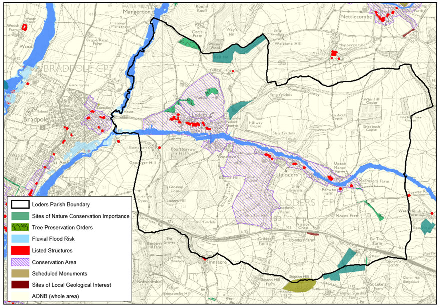
Much of the parish lies within a designated Conservation Area. This means that development should not cause harm to the area’s special historic character.
LANDSCAPE AND NATURE CONSERVATION: Loders Parish is situated in an area of outstanding, diverse and unspoiled countryside. The neighbourhood Plan area lies within an Area of Outstanding Natural Beauty (AONB), which as a national designation has the highest status of protection in relation to landscape and scenic beauty. The underlying geology gives the neighbourhood plan area its distinct landscape. Bridport Sands, greensands and outcrops of limestone shape ‘rolling hills’ and a complex landscape of ‘small, conical hills with steep slopes and incised clay valleys’. Grazed pasture is found on the valley floors, large arable fields on the valley sides and ‘undulating’ hills of mixed woodland [WDDC Landscape Character Assessment 2009]. There are also ’dense, species rich’ hedgerows along the valley bottoms with significant areas of wet pastures. This makes for important Sites of Nature Conservation Interest at Icen Farm, Peascombe, and Bell Hill. These are local, rather than national or European, wildlife designations, but nonetheless indicate sites of some ecological importance. In addition, records from the Dorset Environmental Records Centre show that the Loders Neighbourhood Plan contains European Protected Species, such as Otter, Bat, and Water Vole.
FLOODING: Loders Parish lies along the River Asker valley. Numerous springs feed the river even during extended dry periods. During wet periods the river is liable to flood, and there is also a risk from natural surface-water run-off from the surrounding hills in the event of heavy storms, causing flooding in properties outside the river flood plain.
Map 2: Main Designations and Constraints
POPULATION:The total residential population of Loders Parish
as given in the 2011 Census is 518 with 74 children under the age of
16 and some 136 residents over 65 years. There are 228 main residences
and 44 second homes [2011 Electoral Roll and Council Tax Records].
Overall, the number of people living in the parish has remained relatively
stable over the past four decades. Looking back over the last
3 census records, more people are now in the 45 to retirement age bracket,
with fewer numbers in the under 18 years, 18 to 44 years or above retirement
age brackets. This could be for a number of reasons, possibly
to do with house prices, the rural nature of the parish and range of
jobs and facilities in the local area. With this age profile it
is perhaps not surprising that nearly half of the households are made
up of couples with no dependent children.
There are currently nine households on the housing register with a
‘local connection’ to the neighbourhood plan area, mostly
looking for affordable rented accommodation.
HOUSING:Housing in Loders tends to be larger than average,
both in terms of the number of bedrooms and overall rooms. More
than half of homes are detached (much higher than average), and this
higher concentration of larger, detached homes also means that house
prices are higher than average. There are comparatively few properties
available for rent.
There have been no new homes built (other than one for one replacements)
since 2006, when the development boundary was removed from the adopted
local plan. Looking at the number of new homes built on average
over the past 12 to 15 years, the average (gross) is just under one
home a year (so about 10 homes to the end of the plan period).
The average build rate was higher in the 1990s, when it included the
development of the Highacres estate.
BUSINESS AND EMPLOYMENT:The defining nature of the parish
historically has been agricultural. Even today, there are seven
working farms in and around Loders. The majority of local businesses
are in the service sector, particularly linked to professional, scientific
and technical activities. Manufacturing also features in the parish
together with tourism-based businesses (holiday lets and B&B's and
food services). Unemployment is low at less than 2%.
COMMUNITY FACILITIES: St Mary Magdalene Church a grade I listed building dating back to the thirteenth century, lies at the eastern end of the village; there is also a Methodist Chapel, a village hall, a primary school and nearby small village playing field and two pubs and allotments. These important facilities underpin the health and vitality of the local community and which local people wish to see safeguarded.
SERVICES AND UTILITIES: The majority of properties in the parish are connected to mains sewers, water and electricity. There is no mains gas supply to most of the village. Renewable energy such as solar panels, photo-voltaic cells, bio-mass, ground or air sourced provision is a growing source of supplementary energy to individual properties in the parish. The 2012 parish survey showed that take-up of broadband is particularly high, with 84% (at least 4 in 5 households) connected on-line. Unfortunately the connection speeds are abysmal, and although high speed broadband is being rolled out to most rural areas in Dorset, there are no plans as of January 2015 for this to reach parts of the parish including Uploders and Vinney Cross. The area is also poorly served with mobile phone signal coverage, with most residents (76%) saying they have poor or no reception. Unless electronic communications can be improved this will inevitably mean that residents and businesses will be disadvantaged.
CRIME: The area is comparatively safe, with few reported incidents.
TRANSPORT AND ROAD SAFETY: Most households run at least one
car, with most working residents (90%) use their vehicles to get to
and from work. Access to public transport within the village settlement
is limited – there is a daily bus service which serves the village
connecting to Bridport. Connection to the main public bus network
(Axminster to Weymouth) can be made at Vinney Cross on the A35.
Only 5% of parishioners regularly use the bus service.
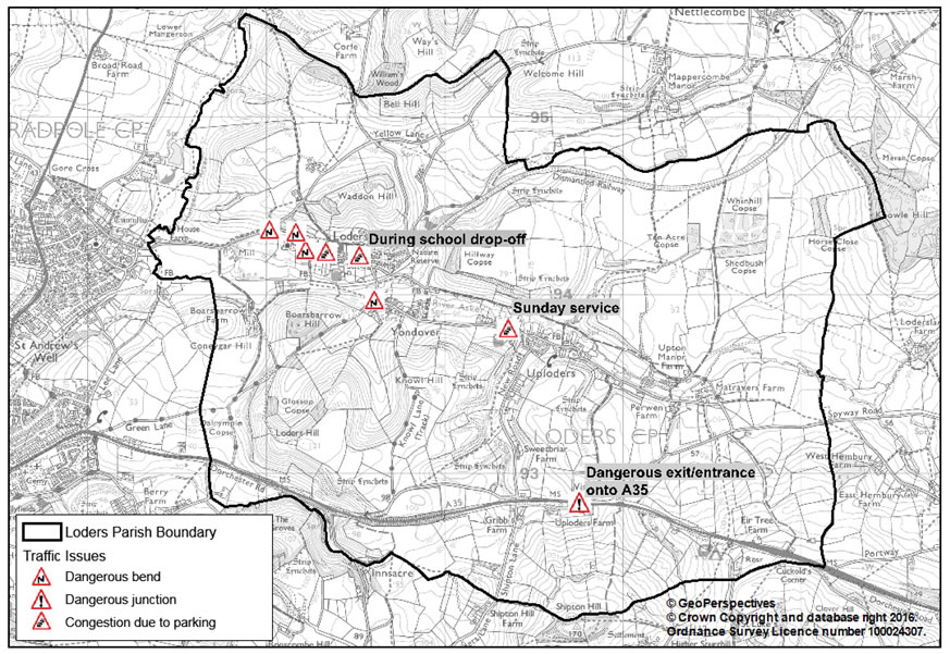
The nature of the rural lanes, which are narrow and in places have limited visibility around sharp bends and significant on-street parking in the built-up areas mean that local people are worried about traffic problems and potential traffic accidents. The key areas highlighted in the Parish Survey were the A35 junction to Uploders, and the area outside the village school, and further along Main Street where parking causes congestion. Large lorries in particular create problems, and there are a number of sharp corners that are potentially dangerous.
Map 3: Traffic Issues
< Previous | ^ Top | Next >