
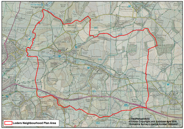
The Neighbourhood Plan Area: The Parish of Loders forms the boundary for the Loders Neighbourhood Plan (LNP). See Map 1. The parish lies within the West Dorset administrative district.
Map 1: Loders Neighbourhood Plan Area.
PURPOSE: This document has been prepared by the LNP Steering Group, consisting of volunteers from the parish, in association with the Loders Parish Council and with advice of West Dorset District Council planning officers.
The Localism Act 2011 provides that planning policy developed by communities shall, if passed by an independent examination and a local referendum, be adopted by the Local Planning Authority. The policies of the Loders Neighbourhood Plan provide an important tool for residents to influence what is built in the parish in the plan period to 2027.
The aims and policies of the neighbourhood plan are based, amongst
other things, on the Loders Parish Survey (2012) whose questionnaire
circulated throughout the LNP area and was responded to by 81% of the
population. Other key local documents on which the plan is based
include Loders & Uploders, Powerstock & Nettlecombe Conservation
Area Appraisal (L&UP&NCAA) together with extensions to
the conservation areas, which was approved and adopted by West Dorset
District Council in December 2007 and the Village Design Statement
(2000) which was adopted by West Dorset District Council as Supplementary
Guidance.
The Loders Neighbourhood Plan has been prepared within the context set by the National Planning Policy Framework (NPPF), and the existing and emerging policies of the West Dorset District Local Plan. Together these will provide the development plan for the parish. The neighbourhood plan policies will work alongside and in compliance with those of the District Local Plan and, where appropriate, replace policies in the Local Plan where they overlap.
ACCOMPANYING DOCUMENTS: in preparing the Loders Neighbourhood Plan, the following information has also been compiled:
POLICY PRIORITIES OF THE LODERS NEIGHBOURHOOD PLAN AND ITS RELATIONSHIP TO OTHER DEVELOPMENT PLAN DOCUMENTS AND POLICIES
The policies in this Neighbourhood Plan, together with the Local Plan,
should be read as a whole. Often several different policies will be
applicable to a single development proposal. Just because a development
proposal accords with one policy does not mean that it will be acceptable.
In reaching decisions, all the relevant plan policies, together with
other material considerations, must be taken into account. Where there
is ambiguity between the Local Plan and Neighbourhood Plan policies,
the decision should follow the policy contained in the most recently
adopted plan.
This Neighbourhood Plan reflects the strategic needs and priorities
of the wider local area, as set out in the West Dorset, Weymouth and
Portland Local Plan (2015). In the context of this neighbourhood, which
is particularly sensitive to change, the over-riding objective in the
Local Plan is the protection and enhancement of the outstanding natural
and built environment, including its landscape, biodiversity and geodiversity,
and its local distinctiveness.
The Local Plan defines development boundaries around the main towns
and larger villages. These centres will be the focus for growth at a
scale appropriate to the size of the settlement. Outside of the development
boundaries development will be more strictly controlled.
The Local Plan did not include a defined development boundary, but
noted that Loders and Uploders were settlements with a population of
over 200 people, where the re-use of existing buildings may help to
provide some growth potential. Away from existing settlements, the Local
Plan makes clear that development opportunities will be more limited
to those activities that will help continue to support the rural economy
or help in the long-term management of the countryside and its unique
character.
The policies in this neighbourhood plan have been written to ensure
that appropriate development is permitted in suitable locations, in
terms of what is considered sustainable development for this area. The
policies focus on supporting sustainable growth and protecting those
features that are of particular national and local importance, and should
be read in that context.
THE LAYOUT OF THIS DOCUMENT: The Loders Neighbourhood Plan
is organised as follows:
Following the above INTRODUCTION, section 2 headed OVERVIEW provides a qualitative and quantitative summary description of the principal characteristics of the neighbourhood plan area. This provides a context for Section 3 the VISION, OBJECTIVES AND POLICIES which reflect the sentiments of the Parish based on the survey results and public consultation, and covers Environment, Community, Housing and Business issues. Section 4 examines how the objectives and policies of the neighbourhood plan will be MONITORED AND REVIEWED.
< Previous | ^ Top | Next >