
2.1.1 Chesil Bank comprises the four parishes of Abbotsbury, Fleet, Langton Herring and Portesham, each of which includes the respective villages of those same names. Abbotsbury parish also includes the outlying hamlets of Elworth, New Barn and Rodden, and Portesham includes Corton, Coryates, Friar Waddon, Shilvinghampton and Waddon.
2.1.2 Each village has its own unique characteristics, which means that they may have different priorities and expectations from each other. This adds to the challenge of producing a Neighbourhood Plan which can successfully embrace the entire Parish Council area. For example, Abbotsbury is a prime tourist destination with many small businesses, village shops and tourist attractions. A large part of the housing stock and land is owned by Ilchester Estates with the residential homes being either rented or on a leasehold basis for owner occupiers. Portesham, on the other hand, is the largest community with a school, a thriving village hall and pub, a Doctor’s surgery, plus a local shop / deli, and unlike the other villages has a defined development boundary in the Local Plan. Fleet is a much smaller village situated close to the Fleet lagoon and near to Weymouth. Most of its properties are spaced well apart along Fleet Road, culminating in Moonfleet Manor (Hotel) at the end of the road. It is also a thriving centre of tourism with a number of licensed camping parks and an equestrian facility. Langton Herring is a comparatively small village near to the Fleet lagoon, with a church, village hall, blacksmith and pub but no shops.
2.1.3 Almost the entire Parish is designated as an Area of Outstanding Natural Beauty, and the coastline is part of the Heritage Coast as well as a World Heritage Site. There are many other designations based on the area’s wealth of historic features and wildlife interest. These are described in more detail in section 2.4.
Abbotsbury
2.2.1 Abbotsbury parish is the most western parish in the Chesil Bank group, lying between the South Dorset Ridgeway and the Chesil beach. The parish includes the outlying settlements of Rodden, New Barn and Elworth.
2.2.2 The origins of the parish go back to 6000BC with the first evidence of hunters/gatherers around the Fleet lagoon. There are numerous Neolithic tumuli, a stone circle and long barrow on the Ridgeway above the village. In approximately 500BC the Iron Age hill fort was constructed on the hilltop to the north west of the present day village. There is a Roman signal post on this Celtic hill fort. The first documented evidence attributable to Abbotsbury is a charter dated 1023 when King Canute gave land, including Portesham and Abbotsbury to his ‘huscarl’, Orc. It was Orc who was responsible for building the Abbey in 1044 that he subsequently gifted to the Benedictine Order, together with his lands. Abbotsbury remained the property of the Abbey until the dissolution of the monasteries during the reign of King Henry VIII, after which the Abbotsbury estate was purchased by Sir Giles Strangways. The descendants of the Fox Strangways family, now the Earls of Ilchester, still own much of Abbotsbury village and surrounding lands to this day.
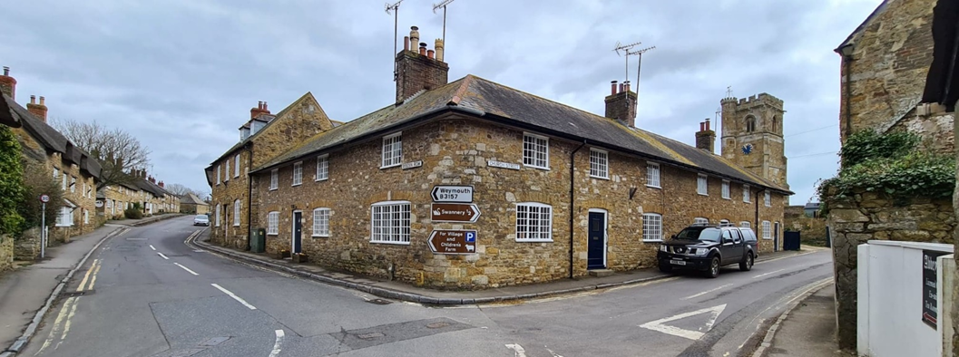
Figure 2: Junction of Chapel Street and Rodden Row in Abbotsbury
2.2.3 During the Civil War, Sir John Strangways and his retainers in Abbotsbury fought for the Royalists. In a fiercely contested battle, centred around the village church and the manor house that Sir Giles had built on the site of the destroyed Abbey, the manor house was fired and many of the historic Abbey documents were lost.
2.2.4 Many of the cottages in the village were built from local stone during the seventeenth and eighteenth centuries, some of which have thatched roofs. The village has many significant buildings of note. The 14th century St. Catherine’s Chapel on Chapel Hill above the village provides a landmark for sailors. The 14th century Grade 1 listed Great Tithe Barn is reputed to be the second largest tithe barn in Europe. The Grade 1 listed Abbey Gatehouse provided one of the gateways to the now demolished Abbey. 14th century St. Nicholas Church with suspected earlier origins shows bullet holes in the pulpit from the Civil War battle. The Granary and the old Dovecote together with Abbey House and Abbot’s Walk provided evidence of the monastic settlement. The 17th century Ilchester Arms public house (formerly The Ship Inn) displays the arms of the Earl of Ilchester from the balcony. Other later buildings of note are the Old School House, the Strangways Hall, the Victorian reading room and the 19th century Congregational Chapel.
2.2.5 Historically, Abbotsbury residents were extremely industrious; fishing, farming, reed harvesting together with the making of nets, baskets, stockings, buttons and candles, providing a prosperous economy. Other more nefarious industries included smuggling and reputedly wrecking!
2.2.6 Abbotsbury today is still a thriving community with tourism and farming providing the mainstay economic wealth. There are major tourist attractions centred around the village; the Sub- tropical gardens, great Tithe Barn and the historic Swannery, which in turn are supported by the many tea-rooms, public houses, shops and art and craft galleries. The village also has the benefit of a village hall, post office, playing fields and allotments, but like the other villages in the Chesil Bank group is disadvantaged by the lack of adequate public transport.
JOSEPH HARDY, ESQ., KINGSTON RUSSELL, 1769
LAT. 50 deg. 45' FUGIO FUGE
Admiral Hardy was born at Kingston Russell, and his old home at Portisham is still in the possession of a descendant on the female side.
From Portisham a walk of four miles leads to Abbotsbury, situated at the verge of the Vale of Wadden and the Chesil Beach. The railway station is about ten minutes' walk from the ancient village, which consists of a few houses picturesquely dotted around the church and scattered ruins of the Abbey of St Peter. The abbey was originally founded in King Knut's reign by Arius, the "house-carl," or steward, to the king, about 1044, in the reign of Edward the Confessor. The building at the south-east corner of the church is part of the old abbey. It is now used as a carpenter's shop, but an old stoup can be seen in the corner. At the farther end of this building is a cell in which the last abbot is said to have been starved to death.
A gate-house porch and a buttressed granary of fourteenth-century architecture, still used as a barn, and a pond, with a tree-covered island, the ancient fish-pond of the monks, are all that remain to remind us of the historic past of this spot.
Fleet
2.2.7 Fleet is the most Eastern parish in the group, adjoining the rapidly growing town of Chickerell. A large number of Chickerell residents walk through the village, mostly using the coastal footpath. It is popular with local dog walkers which brings problems as wildlife is disturbed along the shores of the Fleet and in adjoining open fields.
2.2.8 There has been a settlement in Fleet at least since the stone age and there are links to the roman invaders at Radipole Lake. Together with the Lagoon, Fleet takes its name from the Anglo-Saxon word for an inlet or estuary. There was a church owned by “Bolla the Priest” at the time of the Domesday Survey, and other lands were owned by King William. The lands later passed to the church and then into private ownership.
2.2.9 In 1566, Fleet House (Now Moonfleet Manor) was owned by the Mohun family and their ownership continued until until 1758 when it was inherited by Sarah Mohun who married into the Gould family. It continued to be owned but let out by the extended family including the Goodens until 1867. One tenant was London solicitor Sir Henry Peto who established a reading room in Chickerell and a charity for the relief of the poor. It is the Gooden coat of arms that adorns the main gates to the village. The name "Moonfleet", now adopted by Fleet House, was coined by the author Meade-Faulkner in 1858 when he wrote a fictional tale of smuggling set 100 years earlier in the year 1757.
From the opening passage to John Meade Falkners's Book “Moonfleet":-
The village of Moonfleet lies half a mile from the sea on the right or west bank of the Fleet stream. This rivulet, which is so narrow as it passes the houses that I have known a good jumper clear it without a pole, broadens out into salt marshes below the village, and loses itself at last in a lake of brackish water. The lake is good for nothing except sea-fowl, herons, and oysters, and forms such a place as they call in the Indies a lagoon; being shut off from the open Channel by a monstrous great beach or dike of pebbles.
2.2.10 In the early 17th century (in common with many wetlands across the country) an attempt to drain the Fleet and reclaim the land for agriculture had to be abandoned.
2.2.11 In 1824, in common with many other coastal communities, Fleet was devastated by a storm surge that came over the top of Chesil Bank and this destroyed most of the church as well as several nearby cottages. After this, the Reverend George Gould built new houses and the new church further inland. This resulted in a new road being built past the houses and onwards to Fleet House. Previously the road went below the old church and via Sea Barn Farm to get to Fleet House.
2.2.12 During the first world war, Australian troops were stationed in the village as well as in Chickerell. During the second world war, thousands of American troops were stationed in Fleet and the surrounding area. Fleet House (now Moonfleet Manor Hotel) hosted a meeting between Winston Churchill and General Eisenhower where details of the D-Day landings were discussed.
2.2.13 Holy Trinity is the Memorial Church for the 383rd Engineer Battalion (Separate) of the US Army. Separate indicates that the troops were Afro-American and segregated from the rest of the US army. They later became integrated as the 1349th Engineer General Service Regiment but suffered much discrimination both in the US army and in the UK. The unit was stationed in Fleet from 1943 until 1944 preparing engineering works for D-Day, before taking part in the North-West Europe Campaign.
2.2.14 Other than independent wealth, farming and fishing were once the most important activities in Fleet, and this expanded to ancillary trades as the village grew and these included wheelwrights and shopkeepers and a schoolmistress. Dairy, arable and poultry farming have all been important employers, but in recent decades farming has suffered a substantial decline; four farms in the parish have ceased dairy production, two in the last decade.
2.2.15 Fleet’s farmers still produce wheat and beef to feed the population with local produce but have had to diversify into equine businesses and tourism. Fleet is now a significant tourist destination catering for upwards of 4,000 visitors per night. This creates an ancillary spend worth approximately £2.5m to the local economy, supporting restaurant, cinemas, tourist attractions and other facilities in and close to the parish. Tourism is an added incentive to farmers to preserve and restore the heritage landscape including old stone walls and hedges.
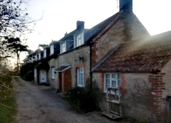
Figure 3: Cottages in Butter Street, Fleet
2.2.16 Many parish residents now derive their income from work outside the village or have retired to the area. The lack of broadband coverage makes home working difficult, although at the time of writing it is understood that fibre broadband is being installed. There is no village hall. The hotel and camping parks provide some facilities including shops but these lie towards the extremities of the parish and are less convenient for residents. The nearest post office and schools are in Chickerell
Langton Herring
2.2.17 There are local archaeological finds around Langton Herring dating from Mesolithic to Roman times, but the earliest written records of a settlement here are of ‘Langetone’ during the reign of Edward the First in the 11th century, and its mention in the Domesday Book as part of the Saxon Hundred of Uggescombe. Some time after the Norman conquest, the village belonged to the French Sarmunville family and became known as Langton Sarnville. Around 1269 a Philip Harang was granted land and the manor at Langton, and by 1315 the village had become known as Langton Herring, as it is named today. After the Enclosure Act in 1760, common lands and waste grounds were annexed by local landowners, primarily the Sparks family and Duchy of Cornwall, who erected field walls, drainage ditches and plantations, many of which are still in place today
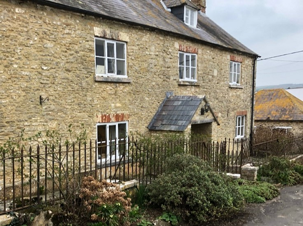
Figure 4: Lower Farm House, Langton Herring
2.2.18 Langton Herring has several buildings of note. The church dates back to the 13th century, although it was extensively renovated in the early 19th century. The village school opened in 1857, but closed in 1943 and became the Church Hall and subsequently the current Village Hall. The recently refurbished Elm Tree Inn fascinates with tales of smugglers, tunnels and secret liaisons, and is a now a registered Asset of Community Value. The Coastguards buildings were originally built to prevent smuggling in Georgian times. At the junction of the B3157 to Langton Herring, the 14th century cross is believed to have been a waymark for pilgrims travelling to the Abbey at Abbotsbury.
2.2.19 There is no war memorial in the village as the village is ‘Doubly Thankful’, having suffered no loss of service men or women during either of the two world wars. During WW2 the Coastguards Road offered access to the Fleet for Barnes Wallis’ team to test the ‘bouncing bombs’.
2.2.20 The centre of the village today remains largely unspoilt, many of the dwellings dating back to the 18th Century, and local limestones predominate, which led to Conservation Area status.
2.2.21 The main uses of land and the main providers of employment in the parish are from the parish’s two farms, fishing, the recently re-opened village forge, holiday cottages and the public house. The small village hall provides a thriving community centre that has immense resident support. The village also hosts an annual charity music festival, and has good links with activities in neighbouring parishes. However, there is no shop or post office or any public transport.
2.2.22 Incredible as it may seem now, in the early eighties the CEGB, as it was then known, identified Herbury, a small peninsula jutting out into the Fleet south of Langton Herring, as a potential site for a Nuclear Reactor. Fortunately for both the local wildlife and nearby residents, an alternative site was chosen.
From the book Thomas Hardy's Dorset:-
Portisham, under the bold, furzy hills that rise to the commanding height of Black Down, appears in "The Trumpet Major" as the village to which Bob Loveday (who was spasmodically in love with Anne Garland) comes to attach himself to Admiral Hardy for service on HMS Victory.
Notwithstanding the fact that Robert Loveday is merely an imaginary character, the Admiral was a renowned hero in real life, and no less a personage than the novelist and poet Thomas Hardy. He lived here, in a picturesque old house just outside the village, and the chimney-like tower on Black Down was erected to his memory.
Portesham
2.2.23 The village of Portesham lies in a valley south of the Dorset Ridgeway about two miles from the sea. The parish includes the outlying settlements of Corton, Coryates, Friar Waddon, Shilvinghampton, Tatton and Waddon.
2.2.24 The first documented mention of ‘Porteshamme’ comes from the Anglo Saxon charter of 1024; the name translated from the Old English means ‘an enclosure belonging to a town’. The settlement of ‘Old Possum’ that used to be up on the top of the hill above the present day village, was described by the monk Nicholas of Guildford as a ‘town’ in the year 1250.
2.2.25 Archaeological excavations in 2000 at Manor Farm, just north of the village church, revealed human presence/activity on the site covering some 4,000 years from the Late Neolithic to the present; further evidenced by the numerous prehistoric sites scattered throughout the parish. Roman burials and pottery have also been found in the parish.
2.2.26 The Manor Farm excavations further suggested that there may have been a Minster in Saxon Portesham pre-dating the existing medieval church; there was certainly a rare late 7th to early 8th century cemetery.
2.2.27 The Domesday Book (1086) lists Portesham as an estate of twelve hides belonging to Abbotsbury Abbey, which it held until the dissolution in 1539 after which it belonged to William Paulet.
2.2.28 There was a mill on the stream on or close to the site of the current Millmead House near Malthouse meadows. From the hillside above Winter’s lane, Purbeck limestone was quarried to build the medieval church and later the 18th to 19th century cottages which still form the historic core of the village. Notable buildings within the village include St. Peter’s church, Methodist Chapel (1867) and schoolroom, Portesham House (once home of Admiral Sir Thomas Hardy), Trafalgar House and Temperance hall.
2.2.29 Farming, quarrying and home braiding of nets for the Bridport industries historically provided the economy of the village. Today many of the residents travel to work in neighbouring towns although farming still continues, albeit at a decreased level of employment opportunity.
2.2.30 Today, Portesham has the benefit of having the local village school and also the Doctor's surgery in the village as well as a superb village hall and a public house. There is a bus service from Portesham to the county town of Dorchester requiring a transfer at Weymouth but it only runs every 4 hours and travel time is excessive. The village is also disadvantaged by the lack of affordable housing for local families.
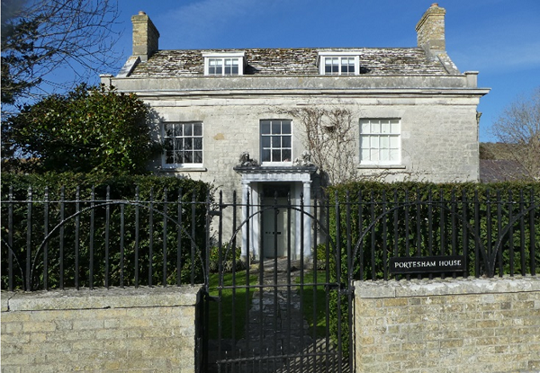
Figure 5: Portesham House
Abbotsbury
2.3.1 The population of Abbotsbury parish including Rodden is estimated to be around 470 people. The total population has shrunk from the time of the 2001 Census, and the latest (2020) population estimates suggest that this downward trend is continuing. The village has a higher number of vacant homes than typical of the wider West Dorset area (and more than a quarter of homes are registered as second homes for Council Tax). There are a relatively high number of private rented homes due to the influence of the Ilchester Estates, as well as affordable homes.
Table 1
| 2011 Census Tables KS101EW, KS401EW, QS405EW | Portesham | Abbotsbury | Fleet and Langton Herring | Chesil Bank NP area |
|---|---|---|---|---|
| All usual residents | 685 | 481 | 240 | 1406 |
| [2001 Census] | 708 | 503 | 236 | 1447 |
| [2020 estimates] | 750 | 468 | 227 | 1445 |
| Density (persons / ha) | 0.4 | 0.3 | 0.3 | 0.3 |
| Average age (mean - years) | 51.1 | 45.9 | 46.6 | 48.6 |
| Average household size (persons) | 2.17 | 2.20 | 2.36 | 2.21 |
| All dwellings | 344 | 256 | 132 | 732 |
| Vacant dwellings / holiday lets * | 28 (8.1%) | 37 (14.5%) | 32 (24.2%) | 97 (13.3%) |
| Average size (bedrooms / all rooms) | 3.1 / 6.2 | 2.9 / 5.8 | 3.4 / 7.0 | 3.1 / 6.2 |
| Home owned (incl. a mortgage) | 236 (74.7%) | 86 (39.3%) | 86 (86.0%) | 408 (64.3%) |
| Private rented | 35 (11.1%) | 80 (36.5%) | 9 (9.0%) | 124 (19.5%) |
| Affordable rent / ownership | 30 (9.5%) | 43 (19.6%) | 2 (2.0%) | 75 (11.8%) |
| Average House Price (2015-2021) | £375,000 | £505,000 | £540,000 | £435,000 |
* includes homes used as second addresses, short-term rentals / holiday lets and properties which were otherwise vacant on the night of the Census.
Fleet and Langton Herring
2.3.2 The parishes of Fleet and Langton Herring are deemed to be too small to be reported separately, so the figures are combined in the Census publications. It is estimated that around a third are residing in Fleet and two-thirds in Langton Herring (based on the households on the Electoral Roll in December 2019). The total population has remained reasonably steady at around 230 people in total. The area has a comparatively high number of vacant homes (holiday / second homes), and this is corroborated by more recent data from the electoral roll. There are very few, if any, affordable homes in either parish.
Portesham
2.3.3 The population of Portesham, including the hamlets of Corton, Coryates, Friar Waddon, Shilvinghampton and Waddon is estimated to be in the region of 750. Housebuilding, in the last 10 years, has helped to reverse the population decline seen in the previous decade. This includes 8 more affordable homes built in the last 10 years, with the completion of Malthouse Meadows. The area has a slightly older age profile than the rest of the area, and marginally lower house prices.
Landscape
2.4.1 Most of the Neighbourhood Plan area is within the boundaries of the Dorset Area of Outstanding Natural Beauty (AONB). The West Dorset Heritage Coast covers much of Fleet, Langton Herring and Abbotsbury, extending about 2km inland, and the entire coastline is part of the Dorset and East Devon Coast World Heritage Site (“the Jurassic Coast”) because of its geological interest.
2.4.2 The Plan area sits largely within the South Dorset Ridge and Vale landscape, with the chalk escarpment to the north leading onto the chalk uplands on the northernmost edge of the Neighbourhood Plan area. The very western end of the area lies within the Bexington Coast landscape. These landscapes are characterised by:
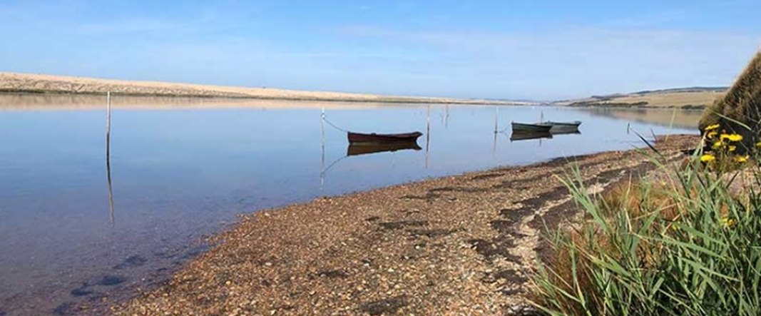
Figure 6: The Fleet, looking west from Langton Hive Point
2.4.3 Intensive farming practices, recreational pressures and associated signage / infrastructure and urban fringe land uses such as pony paddocks (particularly close to Chickerell / Weymouth) threaten the beauty of these landscapes. Masts, modern barns, powerlines and camping and caravan touring parks can have a major landscape impact on the exposed landscapes. Farming practices are now less intensive, and whilst some of the distinctive dry stone walls have fallen into a state of disrepair, many landowners have maintained or restored them. The AONB Management Plan acknowledges the huge contribution that tourism makes to the local economy, including supporting local services, and the importance of managing the impact of visitors so that the AONB retains its natural beauty and special qualities.
2.4.4 Pollution from agricultural run-off into water courses is also a concern, particularly due to the impact upon the Fleet lagoon. Toward the west where development pressures are fewer and much of the land is in good estate management, the landscape is in better condition.
2.4.5 The area enjoys particularly dark skies and a general lack of light pollution
https://nightblight.cpre.org.uk/maps/.Wildlife and Habitats
2.4.6 Chesil Beach and the Fleet SSSI is an internationally important designated wildlife site (SPA, RAMSAR and SAC) – which is therefore given the highest level of protection. The designated area extends beyond the Chesil Bank parishes, and is internationally important for its coastal geomorphology.
2.4.7 The designated area is also internationally important for wintering ducks, geese, and swans, and nationally important for breeding birds.
“On Chesil Beach” written by Ian McEwan, tells of the experiences of a newly married couple on honeymoon, and was adapted for a film in 2017. The story goes that the author "borrowed" some of the pebbles when he was writing the novel. Following cries of outrage from conservationists, the Borough Council "invited" him to return the stones "or face a £2,000 fine". The pebbles were returned. "I was not aware of having committed a crime," he said, "Chesil Beach is beautiful and I'm delighted to return the shingle to it."
A passage of the book reads:
A way lined by weeds of extravagant size-giant rhubarb and cabbages they looked like, with swollen stalks more than six feet tall, bending under the weight of dark, thick-veined leaves. The garden vegetation rose up, sensuous and tropical in its profusion, an effect heightened by the fray, soft light and a delicate mist drifting in from the sea, whose steady motion of advance and withdrawal made sounds of gentle thunder, then sudden hissing against the pebbles. Their plan was to change into rough shoes after supper and walk on the shingle between the sea and the lagoon known as the Fleet
2.4.8 Based on the most recent assessments available, about one-third of the SSSI within the Neighbourhood Plan area is in an unfavourable condition. In 2018 Natural England classed the Coastal Lagoon feature as ‘unfavourable / declining’ due to seagrass die-back that occurred in 2016 / 2017. Reasons for the dieback were unclear – it might be due to nutrient input to the Fleet from the surrounding land or be related to the winter storms in 2014. The latter could have washed seagrass seed out of the Fleet. Some recovery has been observed since 2018 and monitoring continues. Other potential issues noted relate to recreational pressures (particularly off-lead dog-walking that is more likely to disturb vulnerable wildlife).
2.4.9 Off-shore areas have also been designated for their national importance. The Chesil Beach and Stennis Ledges Marine Conservation Zone runs along the length of Chesil Beach from the Isle of Portland to Abbotsbury, and includes a wide range of seabed habitats that support a great variety of species. The area joins onto the Lyme Bay and Torbay SAC, which is of conservation significance because of the range and diversity of the reef and sea cave habitats.
2.4.10 Other Sites of Special Scientific Interest include Abbotsbury Castle (which includes the Iron Age / neolithic hill fort which is also a scheduled monument), designated for its biological interest, and Blackdown (Hardy Monument), designated for its geological and biological interest. These sites are generally in a favourable condition.
2.4.11 There is an extensive network of locally important nature conservation sites and areas of priority habitats area, including areas of deciduous woodland, coastal vegetated shingle, saline lagoons, good quality semi-improved grassland, lowland calcareous grassland, lowland dry acid grassland, and ancient woodland.
Historic Buildings and Features
2.4.12 The Neighbourhood Plan area has a rich historic environment, recognised through its many designated heritage assets and areas. This includes 21 Grade I and II* listed buildings, 131 Grade II listed buildings, three conservation areas, Abbotsbury Gardens Registered Park and Garden and 27 scheduled monuments.
2.4.13 The Grade I and II* Listed Buildings include:
2.4.14 Conservation Areas have been designated covering much of Abbotsbury, Portesham and Langton Herring. A Conservation Area Appraisal, completed in 2007, provides a detailed description of the character of the area including locally important buildings, spaces and views. The appraisal concludes that “The villages are characterised by a general good condition of the building stock, boundaries and the public realm. The Old Rectory, Church St and several farm buildings near Abbey House in Abbotsbury give some cause for concern.”
2.4.15 Scheduled monuments include extensive areas to the south side of Abbotsbury village, relating to: St Peter’s Abbey (which includes many well-preserved structures, such as the tithe barn (reputedly the largest in England), a dovecote, watermill and well-preserved earthworks representing fishponds and buried foundations) and St Catherine's Chapel and its related field system and quarries. A number of these are on the ‘at risk’ register , including barrows on the ridge to the north side of Abbotsbury, structure relating to St Peter’s Abbey, Abbotsbury Castle (Camp), an Iron Age / neolithic hill fort, and many of the barrows on the northern boundary of the Neighbourhood Plan area along the Ridgeway.
Figure 7: Parish Church of the Holy Trinity, Fleet
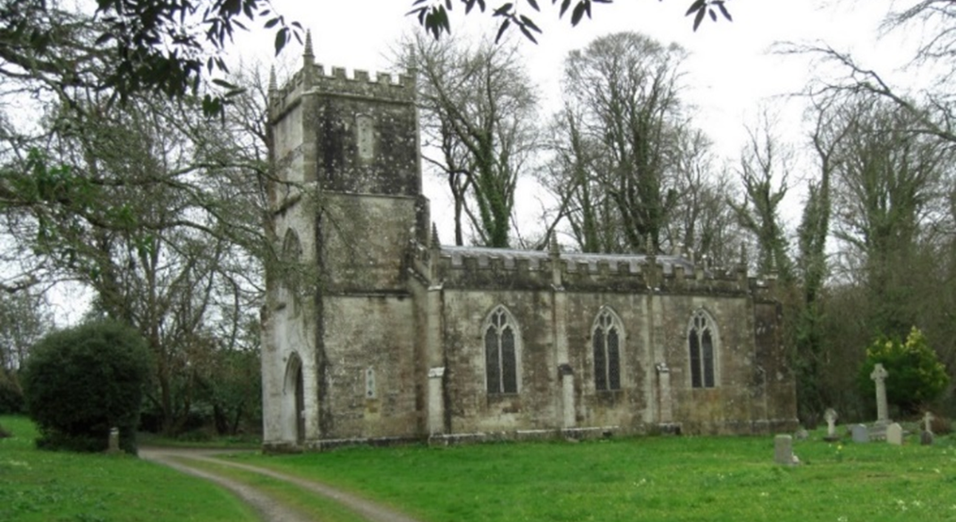
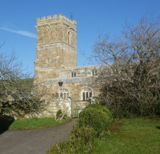
Figure 8: Church of Saint Nicholas, Abbotsbury
< Previous | ^ Top | Next >