
1.1.1 A neighbourhood plan is a document that sets out planning policies for a local area. It is a legal document and forms part of the development plan. It is used to guide decisions on future development, and focuses on the use and development of land and buildings. It also takes account of the associated local social, economic and environmental issues. Once established as part of the development plan for the area, the Local Planning Authority, in our case, Dorset Council, is obliged to use it, although in due course revisions to the Local Plan may supersede elements of it.
1.1.2 In recent years planning applications put forward in this area were mainly for minor alterations and extensions to existing buildings. A few applications were for new dwellings (including through conversions), some were tourism-related, and some were dealing with changes to the access / parking arrangements. The last major application was for the 22 dwellings built on land adjacent to Malthouse Meadow, Goose Hill, Portesham.
1.1.3 Planning applications are decided based on the development plan for the area, although other material considerations may be taken into account.
What might a Neighbourhood Plan cover?
There are no set rules about what topics a Neighbourhood Plan must cover, but examples of what they can cover include:
Figure 1 - Chesil Bank Neighbourhood Plan Area
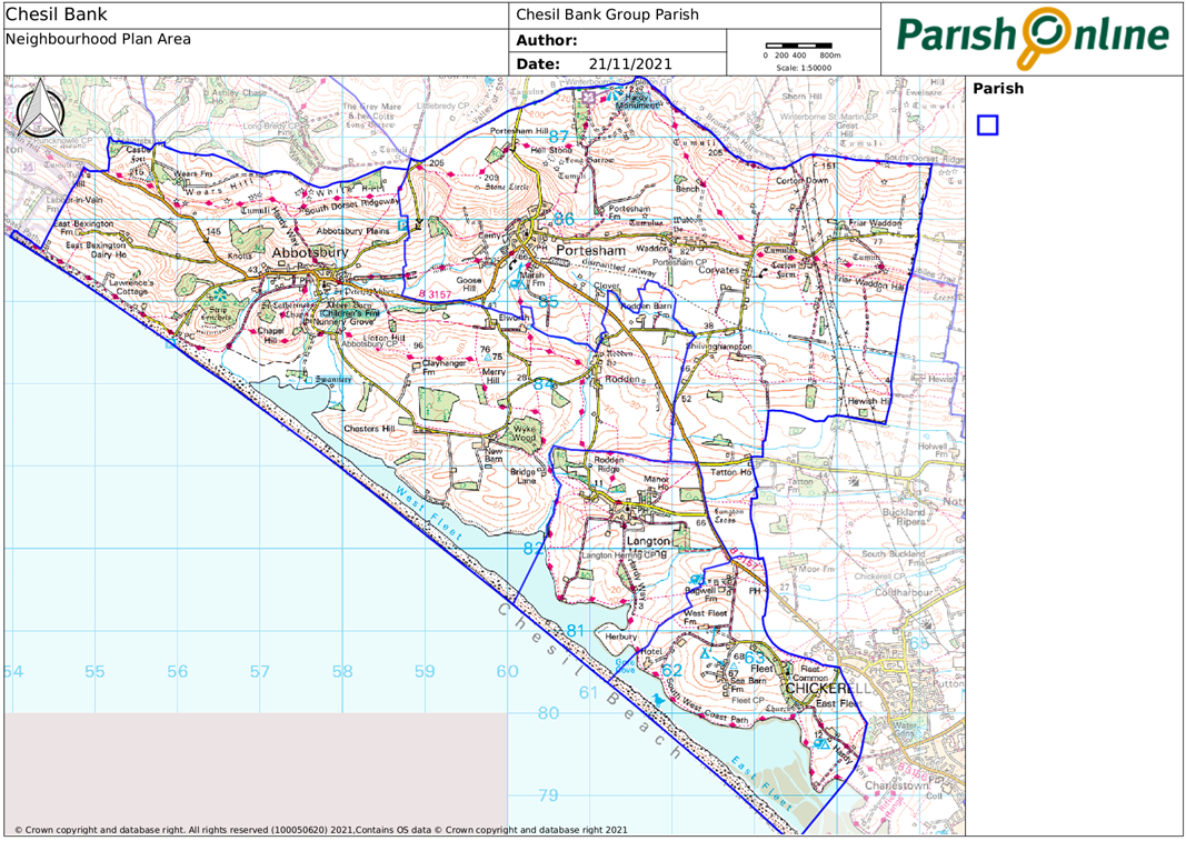
1.2.1 In most parished areas, it makes sense for the Neighbourhood Plan area (the area which the Plan covers) to align with the Parish Council area, as the Parish Council is the responsible body for preparing the Plan.
1.2.2 Chesil Bank Parish Council covers the four parishes of Abbotsbury, Fleet, Langton Herring and Portesham. The Parish Council therefore requested for these four parishes to be designated as the Chesil Bank Neighbourhood Plan Area, and this was confirmed by West Dorset District Council on 10 January 2019.
1.2.3 More information about the area is in section 2.
1.3.1 The possibility of producing a Neighbourhood Plan for the area was first discussed at a Public Meeting held on 22 October 2018 in Portesham Village Hall. It was agreed that work on a Neighbourhood Plan should get underway, and a Steering Group was set up comprising volunteers from the four parishes and Parish Council Representatives. The first Neighbourhood Plan Steering Group was held on 10 December 2018, with the elected Chair being a member of the local community.
1.3.2 The first stage was focused very much on gathering evidence to better understand the local needs and desires. This was done through raising awareness in 2019 (through briefing each Parish Meeting in the May, and a stand at the Chesil Fayre in August 2019) followed by surveys of residents, local businesses, service providers and also working with technical experts to look at the pros and cons of the possible development sites and to develop bespoke design guidance for our area. This culminated in Autumn 2021 with the ‘Options’ consultation, which took a stock-check in terms of the work we had done and asked local residents to tell us what they felt about the options for development in the area. Whilst we need to make sure this plan delivers sustainable development, it also needs to have the full support of the community, which will be tested through a referendum. More information about these early consultations is in section 3.
Pre-Submission Consultation
1.3.3 The first complete draft of the Neighbourhood Plan was consulted on the second quarter of 2022. The consultation ran for more than 6 weeks, and was publicised locally as well as being sent to a wide range of statutory consultees such as Dorset Council, adjoining town and parish councils, Natural England, Historic England and a range of utility providers. All of the feedback from consultation was considered, and further changes made to the plan to respond to the issues raised.
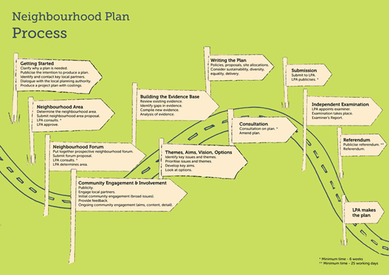
Examination and Referendum
1.3.4 The updated draft of the plan (this Submission draft) was passed on to Dorset Council who appointed an Independent Examiner to check that the plan meets the “basic conditions” set out in the legislation. This included sustainability checks, and testing whether it has had regard to national planning policy and is in general conformity with the strategic planning policies for the area as set out in the Local Plan. The Examiner suggested a number of modifications, and subject to these being made agreed that the Plan could proceed to referendum. The referendum is organised by Dorset Council, and anyone on the electoral roll in the Neighbourhood Plan area can choose to vote for or against the Plan. This last stage is intended to make sure that the local community genuinely want this Plan to be used.
1.4.1 The Local Plan sits alongside the Neighbourhood Plan, and sets out the overarching strategy for development across the area. As such, it sets different policies for the different ‘tiers’ of settlement in its area, as well as general policies for the countryside, and policies reflecting different environment designations as well as generic design and other guidelines. At the time of writing this plan, Dorset Council was in the process of drafting a new Local Plan, which it had anticipated would be adopted in 2023/24 (and more recently by 2026). This plan has therefore taken on board the existing policies in the 2015 adopted West Dorset, Weymouth and Portland Local Plan, as well as checking how these may change in light of the emerging policies.
1.4.2 Although the law requires that the Neighbourhood Plan and Local Plan must be in general conformity, they can say slightly different things. Neighbourhood Plan policies give the opportunity to agree local priorities that are more detailed and this then carries weight in making planning decisions.
1.4.3 There are also Minerals and Waste development plans for the area, and whilst Neighbourhood Plans cannot specifically cover these topics, it is important that they do not undermine key minerals and waste development that is needed in the area. There are no significant minerals or waste sites operating in the area, although there is a planning permission relating to Oddens Quarry (south of Abbotsbury) that allows for occasional working of building stone, and potential for further building stone resources that could be worked (which should be considered before granting consent to build over this resource).
The Plan is expected to last for 10 years, to cover the period 2022-2032. However the need for a review will be considered following the adoption of the Dorset Local Plan, in order to address any potential conflicts between the two plans. It may also need to be reviewed sooner in light of any national policy / legislative changes.
< Previous | ^ Top | Next >