< Previous | Next >
11 Ponders End: South Street, Alma Estate and Station
11.1 Introduction
11.1.1 The three areas of the Alma Estate, sites on and around South Street and Ponders End Station are closely linked to one another. Successful regeneration of Ponders End requires a coordinated approach to these three areas.
11.1.2 The Alma Estate was built in the 1960s, and comprises 717 homes along with 12 retail units that are designated as the South Street Retail Parade. There are four iconic towers which each have 131 flats: Kestrel House, Cormorant House, Merlin House and Curlew House. There are also lower rise homes in the surrounding streets, including Alma Road, Napier Road, Scotland Green Road and Fairfield Close.
11.1.3 The Council has been working with residents to discuss and agree how the estate should be regenerated. The scheme is the flagship housing renewal project for the Council, and it seeks to not only build new homes but to also build communities. A preferred developer was selected by the Council in the autumn of 2013. A planning application for the project is expected in 2014.
11.1.4 The South Street area includes:
- Dujardin Mews, which is due to start on site in Spring 2014 and will provide 38 new homes in a new mews street next to the Oasis Hadley Academy;
- the student housing (Robbins Hall) on Gardiner Close which - following the relocation of Middlesex University from Ponders End - is no longer well located for students and has the potential to be redeveloped;
- two sites forming a large triangle next to Ponders End Station: 171a and 171b South Street; and
- the community facilities on South Street (the MUGA, Youth Centre and Welcome Point), where there is an opportunity to improve their appearance.
11.1.5 Ponders End Station provides an important link to and from Central London for residents as well as access to the Lee Valley Regional Park and Ponders End Waterfront over the footbridge. The station and its surroundings are of poor quality and have limited facilities. Most importantly, access over the footbridge is restricted for disabled users. There is an opportunity to improve connections, facilities and the appearance of Ponders End Station. It is the key opportunity to connect the wider Ponders End area to the nearby Lee Valley Regional Park.
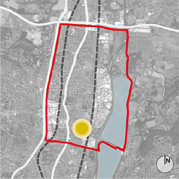 Key plan showing location of Alma Estate, South Street area and Ponders End Station within overall NEE area |
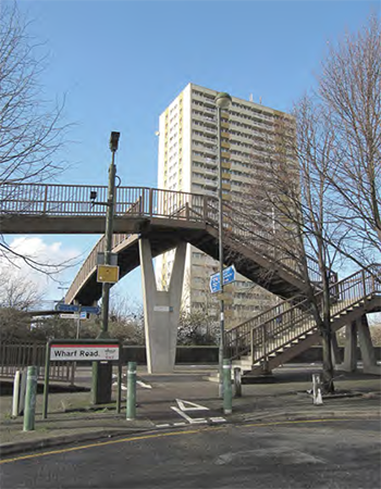 The bridge at Ponders End Station provides a link towards the Lee Valley Regional Park |
London Plan |
Policy 2.14: Areas for Regeneration
Policy 7.4 Local Character
Policy 7.4 Public Realm |
Upper Lee Valley Opportunity Area Planning Framework
(July 2013) |
Objective 1
Objective 7
Chapter 8 |
Core Strategy (Adopted Nov 2010) |
Policy 30: Maintaining and improving the quality of the built environment
Policy 40: North East Enfield
Policy 41: Ponders End |
Adopted Development Management Document
(November 2014) |
Policy DMD28: Large local centres, small local centres and local parades
Policy DMD37: Achieving high quality and design-led development |
Other Sources |
National Planning Policy Framework
National Planning Policy Guidance
Enfield Mini Holland Bid Document, Dec 2013
Ponders End Framework for Growth, (Studio Egret West) 2009
Ponders End Planning Briefs - Feasibility Report (Savills), 2009 |

Aerial view of South Street, Alma Road and Ponders End Station
11.2 South Street Area
11.2.1 South Street has already begun to be transformed: public realm works have changed the character of the street, making it more pedestrian and cycle friendly and the completion of the Oasis Hadley Academy has created a new architectural and social landmark. A planning application has been approved for residential development at Dujardin Mews (formerly known as Academy Street) and this is due to start on site in 2014. The Council has selected a preferred development partner for the regeneration of the Alma Estate, and a planning application is expected to be submitted in 2014 with construction due to start - subject to securing planning permission - in early 2015.
11.2.2 However, the area still has a number of issues that need to be addressed and opportunities for improvement. Figure 11.1 opposite sets out these issues, which include:
- the cluster of existing community uses (the MUGA, Youth Centre and Welcome Point) do not relate well to South Street and the buildings are of low scale and quality;
- the buildings on the Alma Estate relate poorly to South Street, and the green open spaces feel somewhat ‘left over’;
- Ponders End Station is unwelcoming, and the bridge providing links for pedestrians and cyclists is functional but unattractive;
- Dujardin Mews will introduce a new high quality street, with the buildings designed to positively terminate views;
- In contrast, the student housing on Gardiner Close is of very average quality and misses an opportunity to respond to the view southwards along Nelson Road. With the relocation of Middlesex University, this student housing is now remote from higher educational establishments and as such is not well located. It is now being marketed to NHS/ key workers;
- the north side of Gardiner Close has exposed rear and side garden boundaries that are unattractive and vulnerable to crime;
- there is potential to redevelop Gardiner Close to reflect the character and quality of Dujardin Mews; and
- 171a, 171b and 173 South Street form a large triangular site next to Ponders End Station. 171b is vacant and 171a/173 is occupied by a run down four storey apartment building. A planning application has been submitted for 171a/173 to refurbish the existing building and provide additional dwellings along Woodall Road.
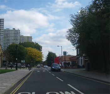 South Street: Looking east towards Ponders End Station |
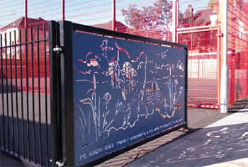 The MUGA on South Street |
Figure 11.1: South Street Area- Key Issues

Policy 11.1: South Street Area
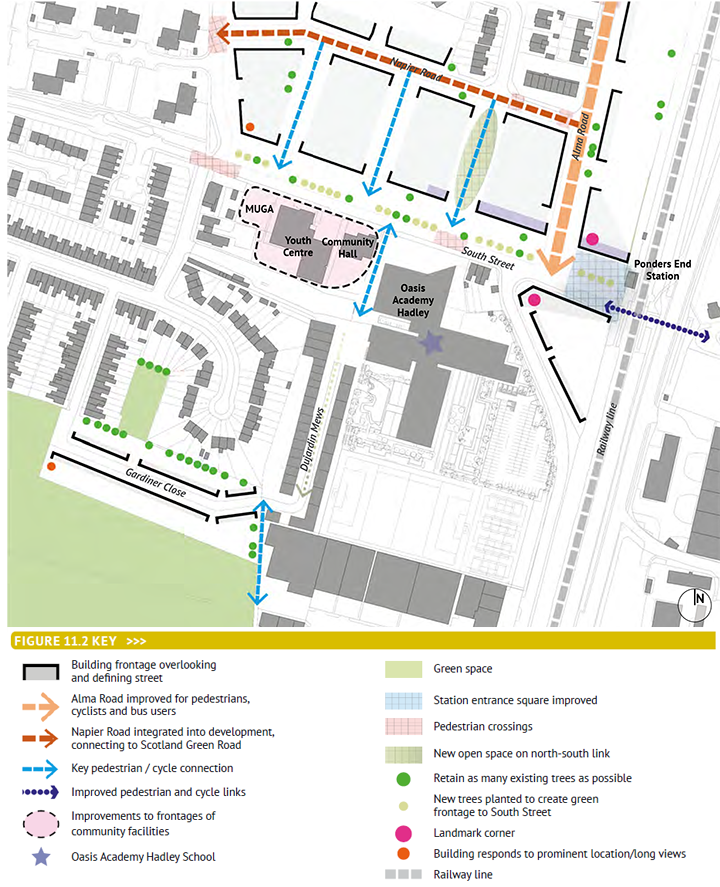
The redevelopment or improvement of the range of sites identified in Figure 11.2 opposite will continue the upgrading of South Street. Key principles include:
- improve the frontages of the Youth Centre and Welcome Point community buildings onto South Street. Improvements could include landscape works to the areas in front of the buildings and/or improvements to the buildings themselves;
- reproviding the MUGA as part of any redevelopment of the community facilities identified in Figure 11.2;
- redevelop the Robbins student housing on Gardiner Close for residential, creating a street that connects positively to Dujardin Mews. Ensure the new buildings respond appropriately to the view southwards along Nelson Road. Orientate new dwellings so that they back onto the exposed rear garden boundaries to the north;
- provide mixed-use development at 171a and b South Street adjacent to Ponders End Station to help define and enclose a new station square. Design the prominent corner of the development to respond positively to views along Alma Road and South Street; and
- ensure that all proposals are coordinated with the requirements of Policies 11.2 and 11.3.
|
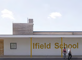 Low cost improvements such as re-cladding, adding a canopy, and using super-graphics could help transform the existing community facilities |
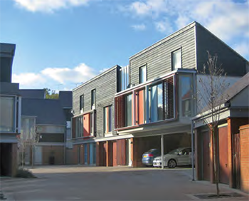 The redevelopment of the Robbins Building could bring high quality new housing to the area |
Figure 11.2: South Street Area- Policy Principles
11.3 Alma Estate
11.3.1 The Alma Estate is located immediately to the west and north of Ponders End Station. It is 10 minutes’ walk from the shops and facilities on Ponders End High Street. The new Oasis Hadley Academy lies to the south. However, despite its good location, the Alma Estate has a number of problems. It does not provide good quality accommodation, and many of the buildings are unattractive. The Council has identified the regeneration of the Estate as a key part of the Ponders End Improvement Area, and a successful scheme has the potential to transform the image and identity of the area.
11.3.2 The Council’s Core Strategy defines the Ponders End Place Shaping Priority Area, of which the Alma Estate forms a part. Core Strategy Policy 41 sets out planning policy for the area, and includes the Alma Estate in a sub-area defined as ‘Ponders End South Street Campus’: Policy 41 does not explicitly require the regeneration of the Alma Estate and instead sets out the following objective:
A pedestrian-oriented community hub at Ponders End South Street Campus, with a new Academy at its heart, an improved relationship between the Alma towers and surrounding community, a proper street network with uses fronting the street and improved access to Ponders End station and between the station and the Lee Valley Regional Park.
11.3.3 The key part of this objective is the creation of a ‘proper street network with uses fronting the street’ and this is encapsulated within Policy 11.2 overleaf. It should be noted that the aim of improving the relationship between the Alma towers and surrounding community has changed: the strategy now is to demolish the towers and replace with new, more appropriate development integrated into the existing community. These principles are encapsulated within Policy 12.1 overleaf.
11.3.4 The Council has selected a development partner to undertake the regeneration of the Alma Estate. The process of selection involved developers producing an initial masterplan for the scheme based on principles set by the Council. A planning application for the scheme is expected to be submitted in the first part of 2014.
11.3.5 This AAP sets out the principles that have underpinned the masterplanning to date and that are expected to continue to inform the scheme as it is worked up in more detail.
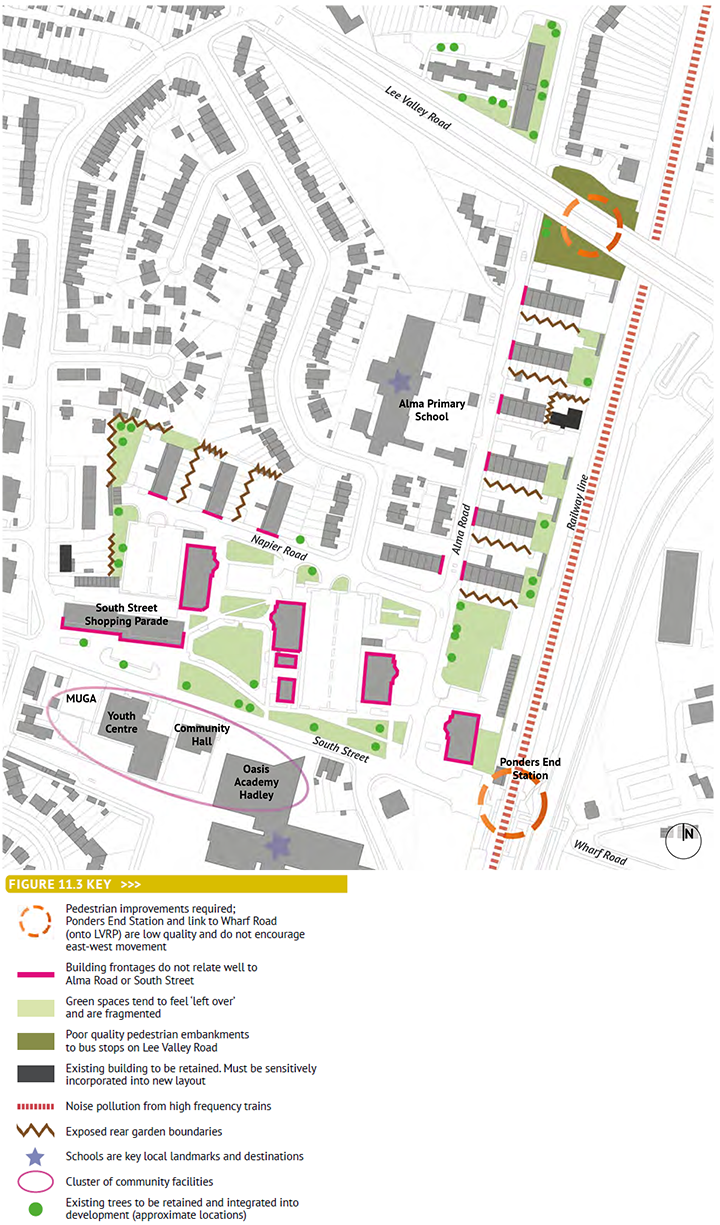
11.3.6 Figure 11.3 opposite identifies the key constraints and opportunities that any redevelopment needs to address. These include:
- the estate does not connect well into the surrounding area: it feels isolated. There are opportunities to provide new linkages and improve existing ones;
- buildings on the estate do not relate well to roads, South Street and Alma Road in particular. There is an opportunity to design new building frontages to define and enclose streets in a more positive way;
- the rear garden boundaries of surrounding residential properties backing onto the estate are exposed. There is an opportunity to improve security for residents by backing new development onto these boundaries;
- the railway line is noisy: any new development will need to be designed to minimise the impact of noise on residents;
- there are existing trees within the estate that should be retained and integrated into the new development;
- the area is not easy to understand - there are opportunities to improve this by providing views to local landmarks such as the station, and by creating an easy to understand;
- the green spaces between buildings feel ‘left over’ - there is an opportunity to design new green space that is better integrated into the redevelopment; and
- there are a small number of sites not owned by the Council that lie within the estate area. If these buildings do not come forward as part of the Alma Estate Redevelopment project, new development will need to respond to them sensitively.
Figure 11.3: Alma Estate- Key Issues
Policy 11.2: Alma Estate regeneration
The regeneration of the Alma Estate should:
- provide a minimum replacement of the existing 717 homes, of which a minimum of 40% are affordable;
- provide a mix of dwelling types, including homes for families;
- provide a new health centre on the South Street frontage;
- locate any commercial mixed-uses (which may be retail (A1, A3) and leisure (D2) on the South Street frontage adjacent to the station; and
- achieve Building for Life ‘Gold’ standard;
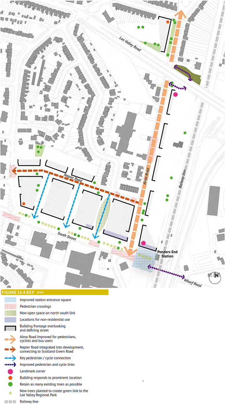
The principles set out in Figure 11.4 must be reflected in the redevelopment scheme. These principles are to:
- develop a positive street frontage to South Street, with new building fronts overlooking the street;
- retain existing trees along South Street and plant new trees where required to create a green frontage to the street, and provide a green link to the Lee Valley Regional Park. Ensure that buildings are sufficiently set back to avoid the root protection zones and canopies of existing trees;
- incorporate commercial mixed-uses adjacent to Ponders End station where footfall is greatest;
- create a green open space connecting South Street and Napier Road. Align with the Alma Primary School so that there are views of the school through the space. Integrate a pedestrian / cycle route within this space;
- incorporate at least two further north-south pedestrian and cycle links into the layout connecting Napier Road to South Street;
- extend Napier Road to connect through to Scotland Green Road, providing a secondary vehicular route;
- improve Alma Road for pedestrians, cyclists and bus users;
- locate building frontages so that they define and overlook Alma Road, creating a positive and safe street;
- locate higher buildings so that they support a clear overall urban design concept, including: ‘protecting’ the wider area from the noise of the railway line; defining key corners and responding to major views; and defining Alma Road and South Street as major streets;
- incorporate existing buildings positively and sensitively into the layout, including responding to existing building lines and to building scale;
- improve the area around Ponders End Station and the pedestrian / cycle link across the railway line to Ponders End Waterfront and onwards to the Lee Valley Park;
- improve pedestrian and cycle links across Lea Valley Road; and
- provide pedestrian crossings of South Street, Napier Road, Alma Road and Scotland Green Road to provide convenient access to local facilities such as schools and play areas.
The redevelopment proposals must also accord with the requirements of Policy 11.3, Ponders End Station. |
 |
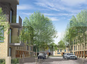 |
Computer generated images from the preferred developer’s bid showing how the Alma Estate could look once it is regenerated |
Figure 11.4: Alma Estate- Policy Principles
11.4 Ponders End station
11.4.1 Ponders End Station serves the south-eastern part of the NEE area, connecting South Street to Wharf Road. To the west, the area is primarily residential and to the east mostly industrial. As well as crossing the West Anglia Mainline tracks, the bridge crossing Mollison Avenue, the major north-south road that serves the Brimsdown Industrial Estate. Figure 11.5 sets out the key issues, and these include:
- Due to its proximity to the Oasis Hadley Academy, the station is an important arrival point for school children. At present, this arrival is unattractive and unwelcoming. None of the buildings on the western side of the railway line have windows at ground floor level, resulting on no overlooking of the car parking / drop-off area or of South Street;
- The station is not obvious in views eastwards along South Street - the bridge is visible, but there is no indication of the station building itself;
- The car parking / drop-off area to the west of the station is congested with cars and is unattractive. There is a major opportunity to improve the quality of this key approach to the station both through public realm enhancements and by ensuring that new buildings positively fronts onto the ‘station square’;
- Wharf Road is important in connecting Ponders End Station and the wider area to the Lee Valley Regional Park. There is convenient access to the major north-south cycle route directly off Wharf Road. However, Wharf Road is not a friendly environment for pedestrians and cyclists. The pavements are narrow or non-existent, and heavy vehicles use the road both to access G.R.Wright and Sons Limited’s Flour Mills and Meridian Business Park to the south; and
- There is a reasonable amount of space between Mollison Avenue and Wharf Road where the steps and the ramp from the bridge land. However, this area simultaneously feels exposed to the traffic on Mollison Avenue and closed in by the trees that obscure views to the bridge from the east. Whilst vehicular access to G.R.Wright and Sons Limited’s Flour Mills must be retained, there is an opportunity to improve this area for pedestrians and cyclists.
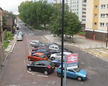 The station 'square' in unattractive and unwelcoming |
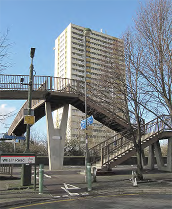 The steps and ramps connecting to Wharf Road are awkward for pedestrians and cyclists |
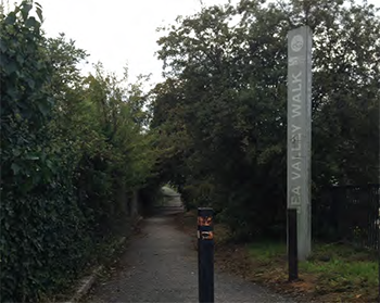 There is direct access to the Lee Valley Regional Park from Wharf Road |
|
Figure 11.5: Ponders End Station- Key Issues

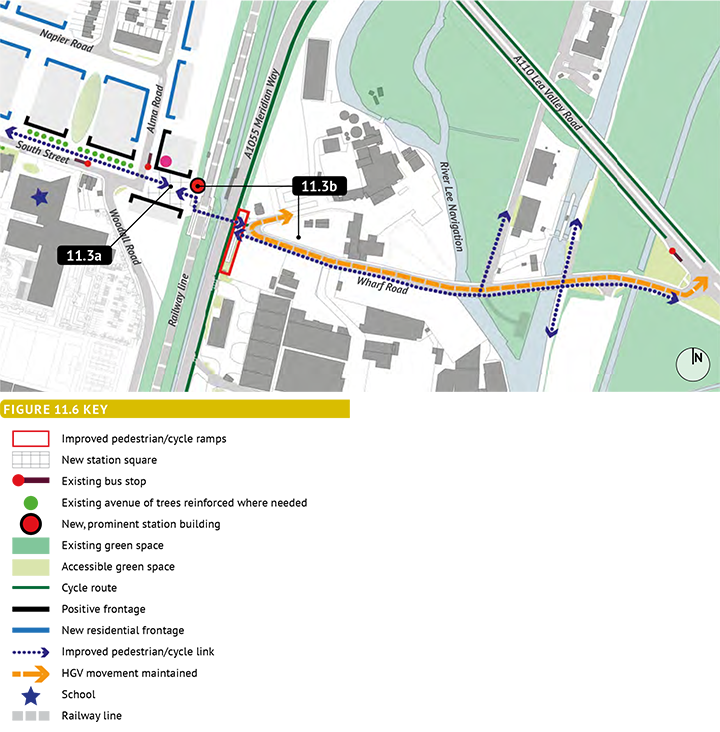
Policy 11.3: Ponders End station
Improve the station and its context by:
- creating an attractive station square to the west of the railway line incorporating car parking, cycle parking and pick up / drop off facilities;
- ensuring that active building frontages positively address the station square, and are sighted to provide clear sightlines eastwards along South Street towards the station;
- refurbishing or redeveloping the station building to create a high quality building that can be clearly seen in views eastwards along South Street;
- improving the bridge link over the railway line and Mollison Avenue, particularly on the east side where there is an opportunity to improve the ‘landing point’ at Wharf Road through de-cluttering, improved paving and signage; and
- developing a scheme to improve the route along Wharf Road for pedestrians and cyclists, including providing clear signage that links with the existing routes adjacent to the River Lee Navigation.
|
11.3a |
Short term improvements to Station Square. |
11.3b |
Major improvements to Ponders End Station to include new station building, improved pedestrian/cycle crossing and improved connection with Wharf Road. |
Figure 11.6: Ponders End Station- Policy Principles
< Previous | ^ Top | Next >


