
2.1 Both national and local planning policies recognise the importance of local community facilities, particularly in rural areas. Not only do they provide access to services and recreation opportunities, but they are also important in providing ways for people to meet and support each other as part of a community. Community facilities typically include local shops, meeting places, public open spaces, sports venues, cultural buildings (such as libraries and museums), healthcare, education, public houses and places of worship.
2.2 Although a number of these facilities may be run by public bodies or charitable trusts, they all depend on being economically viable in the long term. Changes may be necessary to allow the facilities to adapt to meet evolving customer needs demands, and a flexible approach should be taken where this would help retain or improve the service. A further step that can be taken is to register these as an ‘Asset of Community Value’ which can provide the community with more time to make a bid to buy that asset if it comes up for sale – this process is separate from the Neighbourhood Plan.
Did you know?
The Church of St Mary, Pilsdon and the Parish Church Of St Mary, Stoke Abbott are both Grade I Listed – which means that these are amongst the most important Listed Buildings nationally.
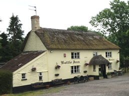
Above: The Bottle Inn, Marshwood
The Bottle Inn hosts the annual World Nettle Eating Championships. The contest began in the late 1980s when two farmers argued over who had the longest stinging nettles in their field and evolved into the World Nettle Eating Championships when one of the farmers promised to eat any nettle which was longer than his.
Policy UMV1. Important community facilities
The following important community facilities should be retained where possible:
Every effort should be made to work with the local community to investigate potential solutions to avoid any unnecessary loss of these valued facilities and services.
Proposals that allow existing facilities to modernise and adapt for future needs, or to diversify in a manner that would support a new or improved community facility to become viable, will be supported, unless this would result in significant adverse environmental impacts.
2.3 There is also a special ‘Local Green Space’ designation that can be given to land that is particularly valued by a local community, provided it is local in character, reasonably close proximity to the community it serves, and demonstrably special to that community. This designation provides a high degree of protection from development, as these spaces are considered to be particularly important now and in the future. However the type of publicly accessible green spaces in our area (which are the National Trust and Woodland Trust sites) do not readily fit these criteria due to their size and distance from the main settlements – so although these can be protected through policy as important area of public open space, they are not classed as Local Green Spaces. Improving public access to these sites will need to be balanced with the need to manage their historic and wildlife interests.
2.4 The Dorset AONB Management Plan makes particular reference the contrasts and diversity of the landscape, which can be appreciated from many viewpoints in the Neighbourhood Plan area, particularly from higher ground. The public rights of way network also provides a really valuable source of recreation and a means of enjoying our most beautiful countryside. The extensive network of public rights of way criss-crossing the area include the Monarch’s Way (a 615 mile walk following the escape of Charles II after his defeat at the Battle of Worcester), the Orange Way (following the route of Prince William of Orange and his army from Devon to London), the Wessex Ridgeway, the Jubilee and Char Valley Trails, which also helps attract tourists to explore this wonderful area. Where opportunities arise, improvements to the public rights of way network in keeping with the rural character of the area are encouraged. This might be in terms of creating new (or reopening blocked) links to provide a better connected network of routes or simply provide access to otherwise unseen parts of the Vale, and replacing stiles with gates to make the network more accessible for those with more limited mobility.
Did you know?
Lambert’s Castle is part of a Site of Special Scientific Interest designated for its grassland habitats, and is in an unfavourable but recovering condition. It is noted for its nationally scarce butterfly species as well as it diverse habitats.
Lambert's Castle and Pilsdon Pen also contain Iron Age hillforts which are designated as scheduled monuments. Historic England has highlighted that their condition is poor – mainly due to the due to scrub / tree growth.
Coneys Castle and Lewesdon hillforts lie just outside of the Neighbourhood Plan area and are also scheduled monuments.
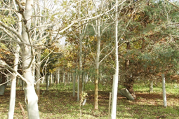
Below: Little Giant Wood
Policy UMV2. Recreational access to the countryside
Development should ensure the retention of existing public rights of way. Proposals to improve public rights of way and improve access to enjoy the countryside will be supported.
Development should not significantly detract from the enjoyment of the following important public open spaces (as shown in the Policies Map):
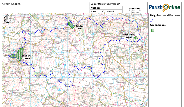
2.5 Back in 2010 the Parish Plan highlighted local resident’s concerns about declines in numbers of birds, animals and insects, as well as native plant species. Whilst Lamberts Castle is designated as a Site of Special Scientific Interest, there is a much more extensive network of locally important nature conservation sites, particularly concentrated in the areas east of Lamberts Castle and also to the northern part of Stoke Abbott parish.
2.6 Ecology appraisals should be undertaken where protected species or important wildlife habitats are known or suspected to be present. Important habitats across the Neighbourhood Plan area include deciduous woodlands, lowland meadows, purple moor grass and rush pastures, lowland calcareous grasslands, lowland dry acid grassland and good quality semi-improved grasslands. Protected species that may be present include bats, barn owls, nesting birds, badgers, hedgehogs, dormice, reptiles and amphibians. So it is likely that ecology appraisals will be needed where development would impact on hedgerows, grasslands that have not been intensively farmed, natural watercourses or ponds, copses / woodland and mature tree specimens, rural barns and other roof voids (where bats may be present).
Policy UMV3. Local Wildlife Areas
All new development should have due regard for the local ecological network (existing and potential) (see Appendix 2), the potential presence of protected species; and take into account national policy requirement to provide net gains in biodiversity where possible.
To achieve this, the potential adverse or beneficial impact of the development on these ecological networks should be fully evaluated, and presence of protected species checked. A Biodiversity Appraisal, Mitigation and Enhancement Plan must be submitted with any planning application for greenfield or brownfield development sites over 0.1ha in size where not currently used as existing residential or business premises, or with any planning application which is likely to give rise to an adverse impact on biodiversity.
2.7 It goes without stating that the protected status of the Dorset AONB, and the impact development would have on its natural beauty, will need to be considered in planning decisions. The latest (2018) landscape assessment considered the Neighbourhood Plan area to be of ‘moderate’ condition and raises the concerns that the easternmost part is declining, and as a result the AONB Partnership is developing a new landscape scale, multi-objective conservation project for this area and the Brit Valley (subject to securing external funding). The small part of Marshwood parish, around Lamberts Castle and including the fields to the north up to the far side of the Bottle Inn, although not in the AONB, does form part of its setting (particularly those parts which can be seen in views from the AONB), and should be treated with the care appropriate to landscapes of such high quality.
2.8 In preparing this Plan, thought has been given to the local landscape features that contribute to the character of the area, as identified through the landscape character appraisals and local consultation. The impact of development on these features, and their contribution to local landscape character, should be carefully considered in deciding whether development is appropriate. Whilst accepting that there may be a need for larger agricultural barns to cater for modern farming practices, and that investment in infrastructure (such as mobile phone masts) is important for today’s way of life, opportunities should also be taken to consider whether any detrimental features could be removed or better screened (for example, by planting new small-scale broadleaved woodlands).
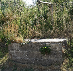
Stone Troughs
Rural track and lanes
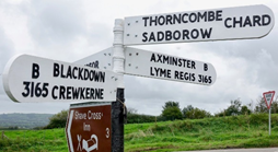
Traditional Fingerposts
Policy UMV4. Local landscape character
Development should respect and enhance local landscape character, including the following key characteristics:
Development proposals that remove features that are detrimental to local landscape character, such as intrusive large pylons and large-scale modern agricultural buildings, as well as enhancing any of the above key features, will be supported.
The design and layout of development should minimise adverse impacts on views from public rights of way over open countryside and preserve and enhance such views where possible
< Previous | ^ Top | Next >