
To promote good and safe access links for walkers, cyclists and other road users, whilst working to reduce the reliance on fossil-fuel transport.
Key policies:
Projects:
|
7.1 Being a rural parish it is not surprising that the car is the dominant form of transport for Stinsford residents, with over 85% of people responding to the 2019 survey saying it was their main form of transport. According to the 2011 Census, over half (59%) of the working population commute by car19 – although this was slightly lower than the previous census (seemingly due to the rise in home working).
7.2 There is no regular bus service to the settlements, although the X12 and 187 services stop on the A35 near the Stinsford Roundabout, and the X11 stops at the Sun Inn on the C12 near Charminster. However the Parish Council will look to liaise with Dorset Council and the local bus companies to encourage better provision, for example through identifying more appropriate ‘stops’ or investigation the potential for a dial-a-ride service.
Project P5. Public Transport Project The Parish Council will work with Dorset Council and bus operators to explore potential improvements to the local bus services in response to suggestions from the local community. |
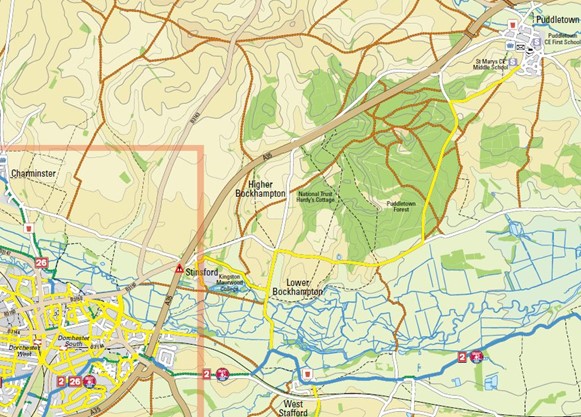
7.3 Few people cycle or walk to work in Stinsford, which may also be a feature of a lack of cycle routes and the seemingly busy, narrow lanes. There are no dedicated cycle routes in the parish – the one advisory cycle route20 is on-road, coming into the parish from the Puddletown direction using the Tincleton Road as far as Bockhampton Cross, turning south onto Bockhampton Lane before heading west via the permissive route through the Kingston Maurward Estate as far as Stinsford. It stops short of reaching Dorchester.
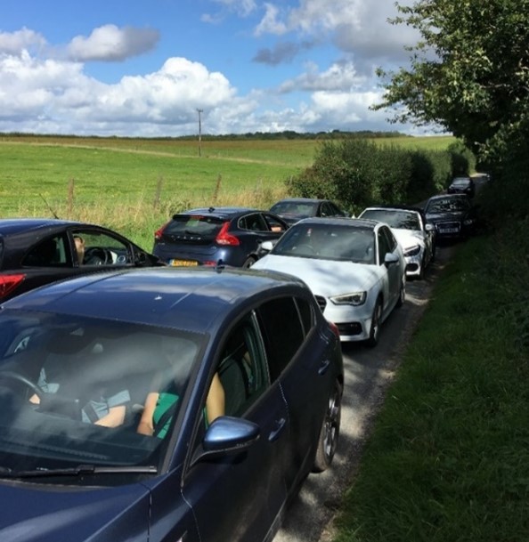
7.4 The same car-dominance applies to visitors. Whilst some may undertake the bulk of their journey by coach or train, their journey through Stinsford Parish is generally by car. As visitor numbers to Thorncombe Wood and Hardy’s Cottage and Visitor Centre have increased over recent years, parking has become an issue and frequently in the summer, visitors leave their cars in passing places and on verges (which further hampers the safe movement of traffic). Most businesses said that the number of visitors and deliveries was likely to stay the same or increase in the future.
Figure 9. Extract from the Dorchester & Surrounding Villages Walking & Cycling Map
7.5 Traffic was the number one factor highlighted by residents (91%) when asked what they disliked most about living in Stinsford. Just over half of the businesses responding to the local business survey also said that they had problems with traffic and access. The main problems mentioned were:
As a result a number of local residents said that they were put off walking or cycling, as the roads were simply seen to be too dangerous.
7.6 The A35 is a very busy trunk road that has the following negative effects on the parish:
7.7 According to reported crashes21 , and excluding the trunk road, the location with the highest number of serious accidents in the parish is Bockhampton Cross (with two serious accidents the last 10 years, as well as a slight collision in the last 5 years), and the main place for cycle accidents has been Hollow Hill and the Stinsford Roundabout, as well as being the other major hotspot for collisions (including a pedestrian hit by a car when the driver was unable to see clearly due to the bright sunlight and shade).
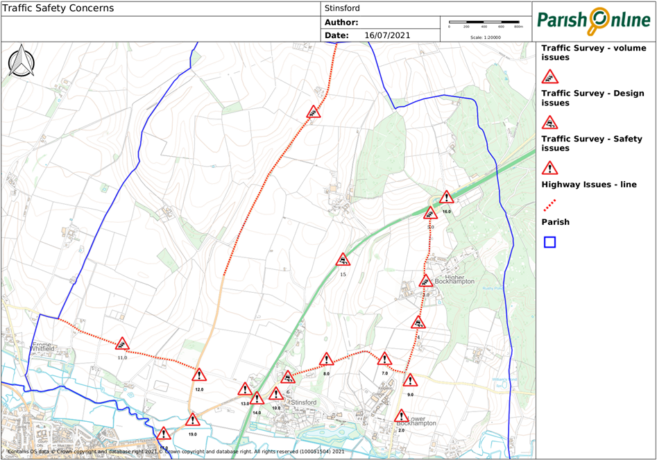
7.8 The map shows the main areas of traffic safety concern as expressed by local residents and businesses, which are explained in more detail in Table 8.
Table 8. Road safety concerns
Ref |
Location |
Issue |
1 |
Lower Bockhampton (Bockhampton Lane) south |
The bridge has been repeatedly damaged by heavy and speeding traffic; there is also a difficult exit from the bridleway for horses, cyclists, pedestrians. |
2 |
Lower Bockhampton north |
Traffic arrives at village at an excessive speed, created by a long, straight access road. |
3 |
Higher Bockhampton – access lane |
There is considerable traffic generated by Hardy’s Cottage and Visitor’s Centre - when the main car park is full and this creates overspill and access problems. |
4 |
Cuckoo Lane / Bockhampton Lane |
There is poor provision of passing spaces; those that exist are badly signed and managed; and the verges have been damaged |
5 |
Cuckoo Lane |
When the A35 trunk road is blocked by accident or heavy traffic, large numbers of vehicles use the lane as an alternative route. Speed is a particular issue with driver frustration. |
6 |
Kingston Maurward main entrance |
This entrance involves a difficult right turn across traffic with poor visibility, for those travelling from the west. |
7 |
Kingston Maurward rear entrance, Hollow Hill |
There is poor visibility with blind bends in both directions. There has been a considerable increase in traffic since the Studio School opened and the College re-organised its bus routes. |
8 |
Hollow Hill (C80) |
The high volume of buses / coaches and narrow functional road width makes two-way traffic difficult. This often forces other traffic onto the verges, causing further degradation. The sunlight and shade created by the trees can also reduce the driver’s vision |
9 |
Bockhampton Cross |
Collisions have been caused by speeding traffic from all directions. |
10 |
Stinsford, Kingston Maurward exit |
Access to the village is affected by traffic from the A35 exiting at high speeds and there is extremely poor visibility. |
11 |
Un-named road from Westleaze to Stinsford Hill (D20661) |
This rural lane has a much higher level of use than designed for, as it can be used inappropriately as a short cut for traffic both commercial and private to avoid delays in Dorchester and on the A35. The relatively high levels of traffic compared to the width and visibility, makes resident access difficult and dangerous. |
12 |
Junction of B3143 and D20661 |
At this junction, high levels of traffic cross a busy, fast road. The crossing has low visibility and no signage. This has caused accidents in the past. |
13 |
Right turn from London (Dorchester) Road B3150 to access D20661 |
The turning is within 20 metres of the A35 roundabout where improvements to the roundabout have increased the speed of traffic entering and exiting. This has caused accidents in the past. |
14 |
A35 Stinsford Roundabout |
The dual lanes on the roundabout are regularly used as an overtaking opportunity for both east and west-bound traffic on the A35 and this has increased the speed and unpredictable nature of traffic at all exits, making this dangerous for both cars and pedestrians travelling to / from Hollow Hill. |
15 |
A35 lay-by |
This effectively a ‘service point’ but it is poorly accessed and turning vehicles can block traffic in both directions. |
16 |
A35 - old Puddletown Road access |
There are no slip roads to access the turn-off and the exit road is poorly signposted from the A35. There have been a number of collisions in this location |
17 |
Grey’s Bridge (B3150) |
There is a hidden footpath entrance directly onto London Road and the adjoining pavement is only a foot wide. Pedestrians face an exceedingly difficult crossing. |
18 |
Slyers Lane (B3143) |
The road is heavily used by heavy traffic from the Piddlehinton Business Park (and also cyclists), and is not wide enough for trucks to pass. The road is particularly narrow and dangerous at Home Farm, with very poor visibility from the properties that access onto it. |
19 |
Right turn from Slyers Lane (B3143) onto London Road |
The speed of traffic from the direction of the Stinsford roundabout makes this junction particularly dangerous for cyclists looking to cross both carriageways to turn right towards Dorchester. |
7.9 The recent establishment of the Studio School at the Bockhampton crossroads, without effective amelioration of the impact of increased traffic, is an example of the importance of understanding and addressing the impact of traffic through planning. The transport statement that accompanied the planning application in 2013 estimated an additional 131 vehicle movements in the morning and afternoon peak hours (of which about 50 would be buses), with the vast majority of trips routed along Hollow Hill to the Stinsford roundabout. It didn’t consider the suitability of the functional road widths – which are generally around 5.0m for much of its length (typical bus and lorry dimensions are 2.5m plus wing mirrors, so 5.5m is generally considered the appropriate width for roads where buses and lorries will be passing22 ). As a result, whilst there are no accidents per se, there are plenty of conflicts between vehicles on this stretch of road (so the road feels much less safe for vulnerable road users) and the road edges are breaking-up. These issues have been raised at meetings of the Parish Council, and taken up with the School, but it is uncertain what, if anything, the School can do to resolve the problems.
7.10 The following policies therefore seek to ensure that in assessing the impacts of development, the rural nature of, and existing problems known, on the many lanes in the parish are fully considered and that appropriate traffic management is encouraged. It highlights specific local issues to be considered in a Transport Assessment, which should be included alongside issues that have wider transport implications.
Figure 10. Traffic safety concerns – the hot spots
Policy SNP14. Traffic Management Traffic management proposals will be supported, where these will help achieve the following objectives:
|
Policy SNP15. Transport Assessments Transport assessments, where required, should:
|
Project P6. Traffic Management Measures The Parish Council will work with local landowners, Dorset Council as the Highways Authority, and Highways England (with regard to the A35) to identify and prioritize traffic management measures that will address the concerns raised by local residents and businesses as described in Table 8. This may include:
|
7.11 A safe and effective cycle network is one which:
7.12 From comments made on the 2019 survey it is clear that residents consider the Stinsford roundabout to be unsafe for cyclists (with the high volume of fast moving traffic). The narrow nature and levels of fast moving traffic along many of the rural roads are off-putting to cyclists. On road, it is important to reduce traffic speeds, and improve the level of road maintenance (particularly at the road margins). They also felt that the bridleway that runs from Greys Bridge into Stinsford is not of suitable quality for most cyclists, particularly as in the winter the surface is only suitable for off-road bicycles. Off-road, there would be a real benefit from having more cycle paths.
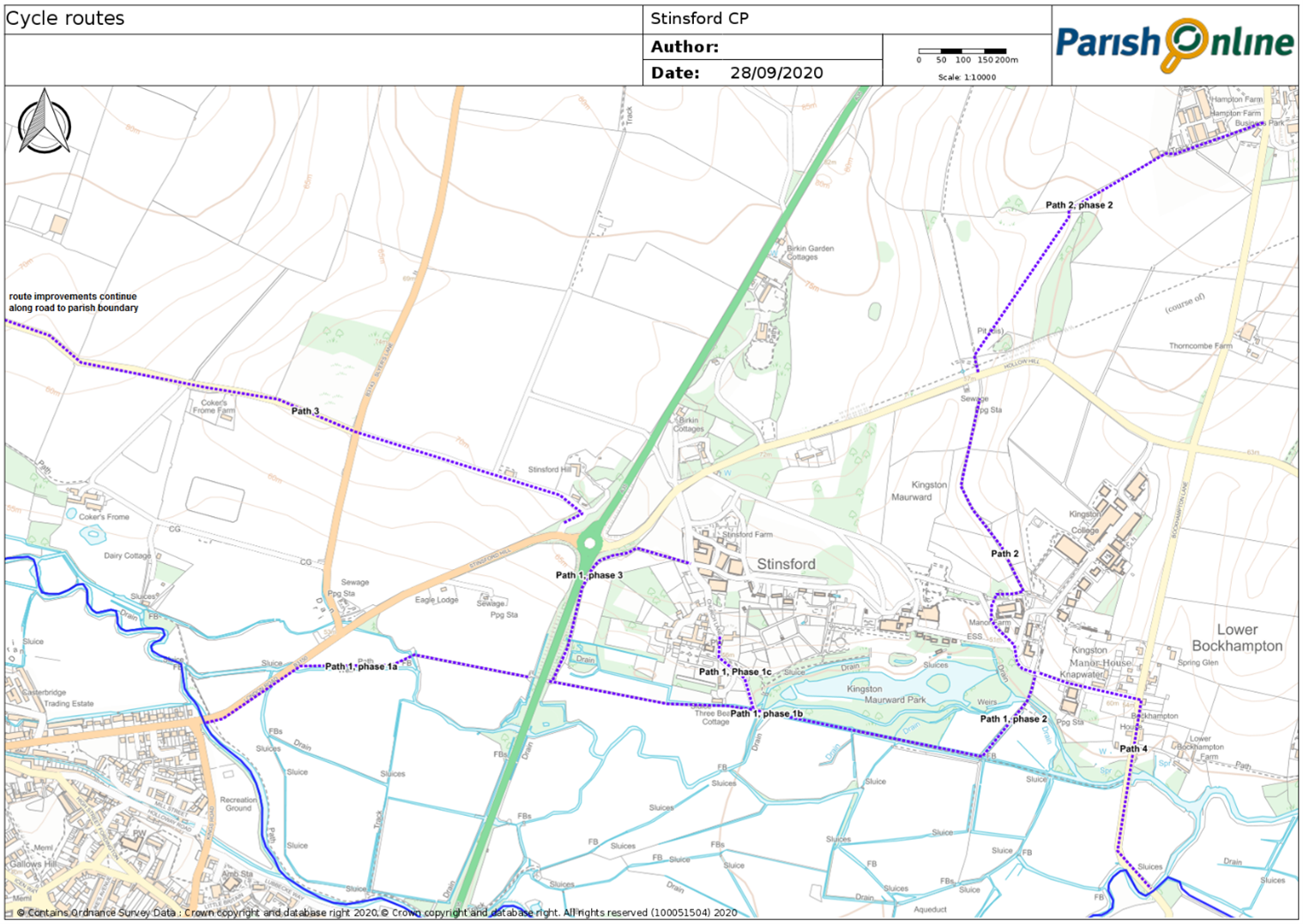
7.13 Local residents and cyclists have worked together to identify a number of potential improvements that could be made to provide alternative safer and more comprehensive network of routes for cyclists, as listed in Table 9. Upgrading the bridleway running from Greys Bridge to Stinsford and Lower Bockhampton to a suitable quality for most cyclists (so it is not limited to off-road bicycles) would have major benefits (particularly given the potential use of this route by school-aged children), and provides the basis for future links to Higher Bockhampton (to both the employment and recreation opportunities there).
Table 9. Improvement opportunities: cycle routes (routes as indicated in Figure 11)
Ref |
Aim |
Location |
Works required |
1 |
Improve links between Dorchester and Kingston Maurward College. Studio School |
1a: Greys Bridge along of B3150 London Road, and bridleway S40/22 to underpass |
Create shared pavement on south side of road to start of bridleway, upgrade path to all-weather multi-user surface to underpass, rural in style, wide enough for shared use. |
|
1b: Underpass to bottom of Cow Track using bridleway S40/22 |
Upgrade path to all-weather multi-user surface, rural in style, wide enough for shared use. Undertake repairs and anti-flood measures at bridges near 3 Bears Cottage. |
|
|
1c: Bridleway S40/13 from river path to Church Lane |
Upgrade path to all-weather multi-user surface, rural in style |
|
|
Include connection to Lower Bockhampton |
2: Cow Track (footpath S40/23) |
Designate as Bridleway. Upgrade path to all-weather multi-user surface, rural in style. |
|
Include connection to Stinsford hamlet |
3: Private 'Machine track’, from underpass uphill to Church Lane by Stinsford Farm |
Negotiate consent to use as permissive route. Upgrade path to all-weather multi-user surface. |
2 |
Improve access to Hardy’s Birthplace, Thorncombe Woods and Puddletown Forest (and alternative onward route to Puddletown avoiding Bockhampton Cross). |
1: Bridleway S40/3 from top of Cow Track to Hollow Hill near Pump House |
Upgrade path to all-weather multi-user surface, rural in style |
|
2: Bridleway S40/3 from Hollow Hill to Cuckoo Lane |
Upgrade path to all-weather multi-user surface, rural in style |
|
|
|
|
|
3 |
Improve links to the westernmost settlements and national cycle network 26 |
Along D20661 from Stinsford Hill to Frome Whitfield (and beyond to link with national cycle network) |
Likely to require off-road alternative to this very heavily-used route (and would need to be considered as part of any strategic decision for development in this area). |
4 |
Improve links to national cycle network route 2 and West Stafford. |
From top of Cow Track along Bridleway S40/3 and Bockhampton Lane towards West Stafford. |
Better signage (and potentially including traffic calming measures) on Bockhampton Lane through and south of Lower Bockhampton. |
5 |
Explore the potential to develop new routes |
Parish-wide, especially north-south links |
Identify new routes and negotiate with land-owners over new access options. |
Figure 11. Diagram showing location of proposed routes
Policy SNP16. Improving cycle infrastructure The improvement and expansion of the cycle route network within the parish will be supported, and should focus on:
|
Project P7. Cycle Project The Parish Council will work with local landowners and the Highways Authority and take account of the views of local residents to bring forward the cycle route improvements identified in Table 9 as funding and resources permit. |
192011 and 2001 census based statistics from https://www.nomisweb.co.uk/ including QS701EW - Method of travel to work and KS015 - Travel to work
20 https://www.dorsetcouncil.gov.uk/sport-leisure/cycling/cycle-routes-and-maps/cycling-in-west-dorset
21 https://www.crashmap.co.uk/Search
22 Guidance taken from Manual for Streets https://assets.publishing.service.gov.uk/government/uploads/system/uploads/attachment_data/file/341513/pdfmanforstreets.pdf
< Previous | ^ Top | Next >