
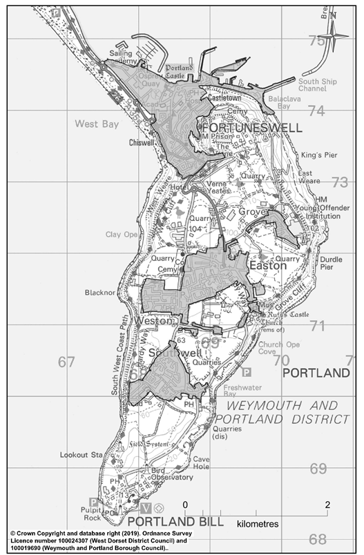
7.1 The boundaries of Portland extend along the Chesil Bank to as far as opposite Littlesea Caravan Park. The perceived boundary however commences at Ferrybridge. The entrance to the Island is dominated by the Chesil Bank and Hamm Beach before entering the more urban setting of Underhill, which has limited natural open space within it, but which is flanked by the Verne Local Nature Reserve together with East and West Weares. East Weares, of which only the north-east corner is visible, is predominantly within the ownership of Portland Port and for many represents a ‘hidden’ and relatively inaccessible side to the Island extending as far down as Church Ope Cove.
7.2 The entrance to the Island and Chiswell and Osprey Quay areas are subject to flooding controls which may impact upon the future of these areas. The environment of Osprey Quay is subject to a management plan and part of the ‘estate’. Ownership of the nine hectares of land at Osprey Quay – including flood defences, open space areas of a business park and the promenade between Portland Castle and the marina was passed from the HCA17 to the Land Trust16 in 2014. The deal included an endowment to be used for the maintenance of the flood defences, which protect the businesses and leisure uses provided at Osprey Quay. The Land Trust is also charged with improving the environment and to explore possibilities of green regeneration that is complementary to the economic development taking place.
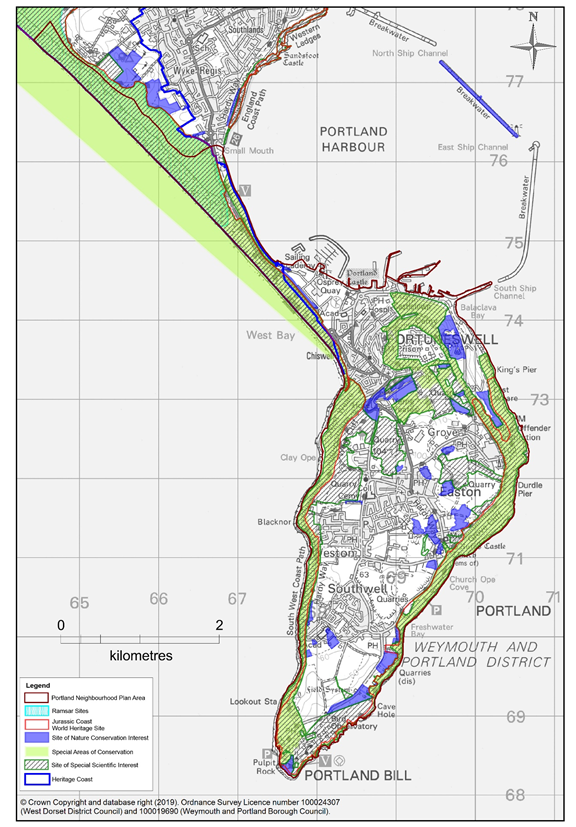
7.3 Ascending to Tophill, it becomes evident that the Island’s landscape is fractured because of extensive quarrying activity, but it has stunning views of the sea and the Jurassic Coast from its cliffs and is well known for its exceptional flora and fauna. Much of the Island is designated as a Special Area of Conservation (SAC), Sites of Special Scientific Interest (SSSI), Sites of Nature Conservation Importance (SNCI) and Local Nature Reserve (LNR). These special and natural environments are safeguarded by both national and local plan policies. The environmental policies of the Neighbourhood Plan focus on ensuring that the built and man-made environment (such as quarries, gravel pits and other mineral workings) created by generations of Portlanders, is similarly respected and any change and restoration that takes place does so in a way that causes least harm and, wherever possible, enhances the unique place that is the Isle of Portland.
7.4 It is this balance of maintaining and improving the environment and at the same time providing opportunities for economic-related development, which is at the core of the Island’s future.
7.5 Restoring the quarries to a productive use is one of many challenges. One option is the creation of a wildlife reserve, which has been successful at Kingbarrow, for example. Alternatively, where restoration conditions are not in place, it is felt that redundant quarries could provide opportunities for appropriate activities, as long as they conform generally with the restoration requirements of the current Minerals Strategy.
7.6 Portland is an historic and special environment in so many ways. The built environment is arguably as significant and important as the natural environment. Portland has around 200 listed buildings and structures. Many of them are in one of the Island’s four conservation areas. Several areas of the Island are on the national schedule of ancient monuments17. There are many more local heritage assets and the whole Island has been identified as having archaeological potential18. The whole Island is also designated a RIGS19.
7.7 The close relationship between the Island’s stone history and its natural and public realm are emphasised by the variety of installations that can be found across the Island. These stretch from more subtle examples such as Nicodemus and Pulpit Rock, to structures such as Lano’s Arch or the tipping bridges; all of which have left features which are considered integral parts of the Island’s heritage. To these can be added a wide range of sculptures, public realm and art installations such as the Spirit of Portland Sculpture and Boat Crane at New Road, Sculpture Park in Tout Quarry, Legacy Trail Cairns, The Memory Stones and Olympic Rings, together with a wide range of memorials including the Cenotaph. The location and setting of many of these are as important as the feature themselves. Encroachment and poorly considered options for land use can undermine their impact and importance just as much as any heritage building.
7.8 To help establish an appropriate framework for the environment policies in the Neighbourhood Plan, the Town Council commissioned a Heritage and Character Study. The Study has helped identify what makes the different parts of the Island special today. AECOM, a leading environmental consultancy, has taken a fresh look at Portland in 2017. Its Character Assessment Report provides important evidence to support the planning policies in the Neighbourhood Plan. Government guidelines say neighbourhood plans should develop policies based on an understanding of the defining characteristics of an area. In doing so, policies can ensure that development responds to local character and history, and reflects the identity of local surroundings and materials, while not preventing or discouraging appropriate innovation. The Character Assessment Report has identified six distinct ‘character areas’ on Portland. It has made recommendations about how development needs to be controlled in the interests of protecting or enhancing their unique character. It was the subject of a community consultation during the spring of 2017, before being accepted as a relevant source of reference for the Neighbourhood Plan.
7.9 The Island has also been subject to a recent (2017) character re-appraisal of its conservation areas20. The Island has four conservation areas:
The resultant document, with its wealth of detail and analysis, has also influenced the policies in this Plan and should be an important point of reference to would-be developers.
7.10 The nature of the historic construction method, sourced mainly from local stone, coupled with its integration into the landscape means that the built environment has significant resonance and complementarity with its natural environment. An example of the ‘harmony’ we regard as important, is the landscape area of the Verne Nature Reserve, which is largely man made as a result of remodelling at the time of construction of the Verne Citadel.
7.11 Almost everybody agrees that all we have that is special must be preserved and protected at all costs. “Portland is a unique and beautiful island with a stunning natural environment and significant opportunities for regeneration and renewal.”21To that end, and in accordance with the recommendation made by the Habitats Regulations Assessment carried out to accompany the Submission Version of the Portland Neighbourhood Plan, an overarching policy Port/EN0 has been included to ensure that all ‘European sites’ are fully protected.
Policy No. Port/EN0 Protection of European Sites
Proposals that will adversely affect the integrity of European sites will not be supported.
Any development bought forward regarding the Northern Arc or enhancement of the piers must ensure that it can be implemented without any adverse effect upon the integrity of the European sites.
| Environment | |
|---|---|
| Aim | Protect the special and unique character of Portland’s natural and built environment |
| Objectives |
|
Policy No. Port/EN1 Prevention of Flooding and Erosion
Development proposals, in areas designated by the South Devon and Dorset Shoreline Management Plan to be protected (‘hold the line’), specifically to prevent coastal erosion or flooding and protect local property and businesses will be supported. In other areas, where economically significant features or infrastructure are at risk, essential flood defence proposals should satisfy the requirements of Local Plan Policy ENV 5.
7.12 Map 6 shows the areas of Portland that are prone to flooding or surface water accumulation. The low-lying areas of Chiswell and Osprey Quay, together with Beach Road, are most at flood risk. The series of storms and gales experienced since the Millennium have challenged the sea defences, which have largely worked and coped well over the last 30 years. Over that period, the newly-developed Osprey Quay area, much of which is in the flood plain, has developed its own sea defences and Flood Defence Plan. These defences include interceptor drains, flood alleviation channels and sea walls. The Portland Breakwaters form an important part of the flood defence.
7.13 The following areas of the Island have also suffered with water related issues in recent years:
7.14 The defined flood zones as shown on Map 6 are:
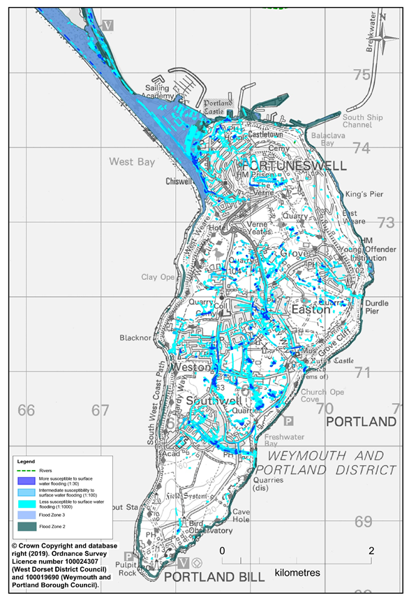
7.15 The Island’s resistance and resilience to flooding is an on-going process. It is almost impossible to prevent flooding that results from major storms, such as that experienced in January 2014 when 15ft waves over-whelmed Chiswell, or to stop Beach Road from being near-impassable at times of very high tides. However, work to increase our resilience or to slow down the rate of coastal erosion resulting from these severe natural events will be welcomed where it is necessary.
7.16 The Shoreline Management Plan22 for Portland puts the issue into perspective. It recognises that there was limited action that could or should be taken to manage coastal erosion and find “the right balance between the needs of local communities, the economy and the environment, to secure a sustainable and affordable approach to the threat while protecting natural interests.”
7.17 For Portland the various scenarios tested over the period of 100 years propose the following action:
7.18 Natural England’s National Character Area profile24 for Portland also supports this approach i.e. by “allowing natural coastal processes to operate unimpeded and realising opportunities to extend or create new coastal habitats and maintain geomorphology, geological exposures and access to fossils; and promoting the benefits of natural coastal erosion as a cost-effective form of coastal defence while protecting from severe flooding both the village of Chiswell on the north of Portland and the road that connects the island to the mainland. While defences should be minimised, and be as natural as possible, they are vital in order to preserve other island characteristics.”
7.19 The most vulnerable settlement area is Chiswell. Defences at Chiswell could be outflanked as the beach to the north rolls back naturally over time. The amount of roll back and outflanking risk is dependent upon the size of wave events, though a large event in the long term is likely to occur. Due to the ‘assets’ in this area, it is unlikely that defence would cease to be provided, so continued defence in some form, but to a greater level, is likely to be required.
7.20 The NPPF (para. 149) requires plansto “take a proactive approach to mitigating and adapting to climate change, taking into account the long-term implications for flood risk, coastal change, water supply, biodiversity and landscapes, and the risk of overheating from rising temperatures. Policies should support appropriate measures to ensure the future resilience of communities and infrastructure to climate change impacts, such as providing space for physical protection measures, or making provision for the possible future relocation of vulnerable development and infrastructure”. Portland Town Council will work closely with the responsible authorities25 to ensure that the strategic flood risk management strategies are kept up-to-date and the flood defence strategy remains appropriate and effective. In particular, the economic significance of Portland Beach Road, and utilities contained therein, may require an earlier review of this area.
7.21 Policy Port/EN1 is generally supportive of development that is necessary to ensure that local property and businesses are protected, and people are kept safe. The policy supports flood defence works specifically designed to protect local property and businesses.
7.22 Where the threat of flood emanates from within an area where the approach in the Shoreline Management Plan is one of ‘no active intervention’, any development proposal specifically designed to protect valuable assets or infrastructure would need to be assessed in accordance with Policy ENV5 of the current Local Plan, which reflects national policy on flood risk, including sequential and exception testing. We would expect the economic value and community significance of the property or infrastructure at risk to be taken fully into account.
Policy No. Port/EN2 Renewable Energy Development
Development proposals for energy generating infrastructure using renewable or low carbon energy sources, including wind and tidal power, will be supported provided there will be no unacceptable effects on the:
Proposals for installations will need to include specific assessments related to these criteria and assessments of the planning considerations relating to specific renewable technologies set out in national guidance.
Community- based renewable and low carbon energy generation initiatives will be encouraged
7.23 The Economic Strategy recognises Portland as an ideal environment for renewable energy companies to thrive. There are opportunities to take careful and responsible advantage of tidal power as well as geo-thermal, solar and wind power development. Portland has the potential to become a leading location to test and develop renewable energy development as well as supporting the development of community renewable energy. The generation of energy locally at a community level offers the opportunity to retain spending on energy for the benefit of local people and the local economy.
7.24 The community has taken an interest in renewable energy. It has already demonstrated this with the Osprey Leisure Centre, managed by the South Dorset Community Sports Trust, a community organisation, which has recently won awards for progressive thinking and action on energy saving, sustainable and renewable energy initiatives, cutting costs and carbon significantly. In 2015, a ‘workshop’ of community stakeholders discussed the potential for Portland to become an Energy Island, following in the footsteps of Eigg in Scotland. It was agreed that it would be good to explore the potential for community owned renewable energy, backed by the creation of a Portland Trust to receive bequests to fund green projects. In the summer of 2019, Portland Town Council declared a climate and ecological emergency and supports the need to move towards being carbon neutral. Policy Port/EN2 is supportive of a Portland Energy Island Plan approach.
7.25 Policy Port/EN2 establishes locally relevant criteria for energy generating infrastructure using renewable or low carbon energy sources that should be considered alongside the national guidance in the PPG and other national policy statements regarding the technical and other planning considerations, when development proposals are formulated. These criteria are aimed, to a large part, at ensuring that the natural environment, of sites and species, is adequately protected. The Habitat Regulations Assessment carried out for the Plan urged us to emphasise the significance of European sites of importance within the policy.
7.26 National planning policy asserts that applications for wind energy development will only be allowed if the development site is identified as suitable for wind energy in either a Local Plan or Neighbourhood Plan. We will work with the local planning authority as it prepares the Dorset Local Plan to consider whether there are suitable locations and a way of harnessing wind energy satisfactorily on a commercial scale on Portland.
7.27 To mitigate any impact on the landscape or wildlife, new ideas around turbine design may have to be awaited and utilised. This would fit well with the aspiration for the Island to become a Research and Development centre. Any proposals would be expected to follow the guidance note issued by the Centre for Sustainable Energy.26
7.28 Proposals for tidal energy installations at appropriate areas on the seaward side of the neighbourhood area e.g. Ferrybridge, Harbour Breakwater will be supported if they meet the policy requirements. Land based operations for larger tidal installations may also be supported.
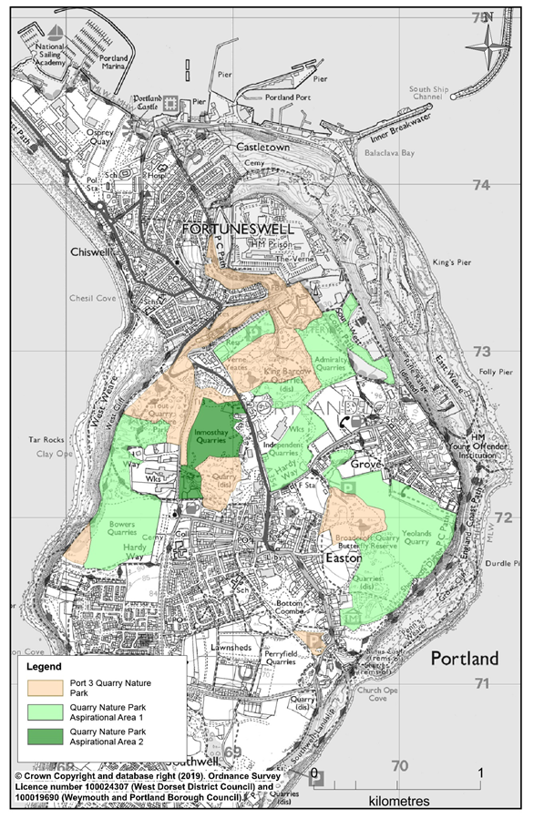
Policy No. Port/EN3 The Portland Quarries Nature Park
Proposals that further the creation of a ‘Quarries Nature Park’ within the areas shown on Map 7 are supported provided:
7.29 The Portland Quarries Nature Park is an important long-term project that will remediate unused and redundant quarry sites, thereby protecting historic and industrial heritage resources, connect and enhance biodiversity habitats and provide a visitor facility that will provide cultural and education opportunities and, in so many ways, celebrate Portland’s unique wildlife, geology and heritage. It was first suggested in the late 1990s and was then brought forward as an Olympic Legacy Project.
7.30 The Portland Quarries Nature Park in its first phase comprises over 60ha of disused Portland quarries along with Verne Local Nature Reserve. It currently links together five key sites, King Barrow Quarry, Tout Quarry, Verne Yeates, Trade Quarry and Inmosthay Quarry, with the aim of bringing new investment to these once neglected sites that are nationally significant for nature conservation, geology and cultural heritage. There is every intention to add additional areas to the Park as opportunities arise and subject to the landowners’ agreement. These areas are currently designated as ‘aspirational’ by the Local Plan.
7.31 Locations within the Quarries Park area, either existing or aspirational, are subject to different nature conservation designations, which will require appropriate mitigation and compensation requirements commensurate with the status of the relevant designation.
7.32 Natural England’s National Character Area profile27 advocates “continuing to support the Portland Quarries Nature Park, which showcases Portland’s geology, the history of extraction and the inspiring sculpture created by carving Portland stone”, as one of the environmental opportunities worth pursuing.
7.33 Local Plan Policy PORT03 recognises the importance of this initiative and allocates land shown on Map 7 below as part of the Portland Quarries Nature Park “to promote sustainable tourism, management of conservation and heritage interest, enhancement of public access and open spaces and opportunities for volunteer and community involvement”. The areas identified in Map 7 include stone reserves and existing operational quarries and mines which are safeguarded by Policies SG1 and SG3 of the Minerals Strategy. Areas of Broadcroft Quarry, for instance, are currently operational and the remaining resource should not be unnecessarily sterilised. The aspiration for this area to form part of the Nature Park is long-term and proposals should not compromise the extraction of safeguarded stone.
7.34 The development of the Portland Quarries Nature Park is consistent with the recommendations of the Portland Heritage and Character Assessment of 2017. It is focussed on the rugged open landscape area of Quarries and Open Space (LCA6). The Assessment recommended that the principles for managing change should focus on sustaining, reinforcing or enhancing those aspects which enhance the industrial character and contribute to the coastal setting. “Development within the disused quarries should be encouraged to celebrate both the industrial heritage on the island and the diverse and high-quality landscape and biodiversity.” Part of the Quarries Nature Park also lies within the Grove and Verne (LCA2) which is significant because of its heritage value.
7.35 Policy Port/EN3 endorses the Portland Quarries Nature Park project and its extension. It supports appropriate development in the designated Park area and the aspirational areas that help realise the visitor potential of the Park in a responsible manner. This may include small-scale activity-related tourism development (in accordance with policy Port/ST1), subject to the necessary safeguards being in place to ensure that the essential character of the area is not compromised.
7.36 Any development or change should serve to reinforce the characteristics of this unique quarried landscape and its ecological systems. In accordance with the Local Plan, the preferred approach is for development, which may affect protected species or habitats, to be assessed through the Dorset Biodiversity Appraisal Protocol28, administered by Dorset Council NET29.
Policy No. Port/EN4 Local Heritage Assets
Development proposals that maintain or enhance the character and setting of any designated or non-designated heritage asset and which enable the asset to be used in a manner commensurate with its heritage significance will be supported.
Any renovations or alterations of buildings or structures identified as heritage assets requiring planning permission should be designed sensitively, and with careful regard to the heritage asset’s historical and architectural interest and setting.
Development proposals in proximity to a heritage asset should provide a clear assessment of the significance and impact of the proposal on the asset and its setting and justify the design approach taken.
7.37 We want to ensure that our history and heritage is recognised and respected. 95% of respondents to the Community Survey 2014 told us we must protect our old buildings and heritage features, of which we have a great deal. This is evidence by the fact that on such a relatively small location, there are four conservation areas. There are 178 Grade II (nationally important and of special interest) buildings and structures on Portland. The Island also has three Grade I (of exceptional interest) and 10 Grade II* (of more than special interest) buildings and structure. Eight locations on the Island are scheduled as ancient monuments. Beyond these there are many other buildings, structures and locations that we regard as being an essential and important part of our history and heritage.
7.38 The NPPF (para. 185) encourage us to have “a positive strategy for the conservation and enjoyment of the historic environment, including heritage assets most at risk through neglect, decay or other threats”. Our heritage assets are important for historical, cultural, urban design and ‘sense of place’ reasons. They help define and make Portland such a distinct location. We wish to ensure they continue to play a significant role in the life of the Island. We want to ensure that uses are commensurate with the building’s heritage.
7.39 Policy Port/EN4 sets out policy requirements in the interest of protecting both designated and non-designated heritage assets. We have urged Weymouth and Portland Borough Council to establish a Local Heritage List. In its absence, on the advice of Historic England, Portland Town Council will establish a Schedule of Assets of Local Heritage Value. Members of the community can nominate buildings or structure for inclusion on this Schedule. It is hoped that those included on the Schedule will eventually be incorporated into the local planning authority’s List of Local Heritage Assets.
7.40 Any heritage assets identified in the Town Council’s Schedule of Assets of Local Heritage Value and/or as ‘important local buildings’ in the various Conservation Area Appraisals on the Island, should be treated as non-designated heritage assets, for the purposes of policy Port/EN4 and applying Local Plan Policy ENV4. We expect any development near a heritage asset to have a positive impact on the asset and our local heritage. Development proposals should adhere to Local Plan Policy ENV4, which requires proposals affecting the significance or setting of a heritage asset, whether statutorily designated or not, to provide “sufficient information to demonstrate how the proposals would positively contribute to the assets’ conservation”.
Policy No. Port/EN5 Historic Piers
Development proposals to protect, conserve and/or enhance the historic piers of Portland will be supported.
The renovation or alteration of structures should be designed sensitively, and with careful regard to the pier’s historical interest and setting, as well as the need to avoid any significant harmful impact on the Jurassic Coast World Heritage Site.
Any development proposals brought forward regarding enhancement of the piers for social or economic use must ensure that they can be implemented without any adverse effect upon the integrity of the European sites. Proposals that will adversely affect the integrity of European sites will not be supported.
7.41 The east coast of Portland is the location of several historic jetties or piers that were for built mainly for the stone industry to enable transportation by sea, mainly to London. The remnants of Kings Pier Folly Pier and Durdle Pier, all in the ownership of Portland Port, date back to the 17th century and are considered worthy of protection. With careful restoration and conversion, the piers may yet have a use, economically or socially. They have been mooted as possible ferry access points from Bournemouth and Poole and Isle of Purbeck.
7.42 King's Pier is a 17th-century stone shipping quay, located at the boundary of land owned by Portland Port Ltd. When active, King's Pier was one of the most important stone shipping pier sites. Historical documents show that King's Pier was completed in 1622 for the shipment of stone to Whitehall in London. The Pier fell out of use in the 19th century. The remnants of the King's Pier have served as a breakwater with fence on it to mark the start of the naval base, now the Port.
7.43 The current Folly Pier structure dates to 1765. The name Folly had originated from the fact that the Pier's exposed position beneath East Weares, coupled with landward inaccessibility, often made its use difficult. Once quarrying in the area reduced, and quarries moved inland from the cliffs, the pier fell out of use, and any cranes were removed.
7.44 Durdle Pier was constructed about 1745. It had the easiest access of the piers. By the 19th-century the Pier was reached by many tracks running from various quarried sites along East Weares. Once quarrying in the area reduced, and quarries moved inland, fishermen became the Pier's main users. The Pier’s crane was one of the few remaining cranes used for lifting boats from the water around Portland's coast, and was still used into the 21st century, until the crane became broken and beyond repair. During the storms of early 2014, the Pier's crane was destroyed by the sea.
7.45 We hope that the piers can be brought into use for the economic and/or social benefit of the Island, but that should be subject to satisfying any security concerns of the Port. There has been recent interest in aquaculture and developing diving tourism off Portland. The current transport strategy30 amongst its sustainable transport options includes “support for the development of waterborne transport (Jurassic Coast)”. Policy Port/EN5 recognises that the pier sites could have value in future in providing links between land and sea but stresses that the history of the sites and structures must be considered. The NPPF (para. 197) says that “the effect of an application on the significance of a non-designated heritage asset should be taken into account in determining the application. In weighing applications that affect directly or indirectly non - designated heritage assets, a balanced judgement will be required having regard to the scale of any harm or loss and the significance of the heritage asset”.
7.46 The historic piers are situated along the Portland Coastline which, in the majority, is designated as a European Site. Therefore, according to the Habitat Regulations Assessment (HRA) there is potential for the permissive aspects of the policy to cause an impact through recreational pressures and ‘pathways’ such as: direct land-take; construction-related effects (dust); and water quality (surface water runoff). As recommended by the HRA, we have included a requirement in the policy Port/EN5 that development proposals for the re-use of any of the piers should show that there will be no adverse effect upon the integrity of the European sites either during construction or the operational stage of the development. Any projects brought forward under the policy should be subject to early pre application consultation with Natural England.
7.47 Bringing the piers back into use in a way that respects their history and heritage and avoids harm to local wildlife and habitats will be a challenge; but we regarded it as a worthy one that is consistent with our overall approach to growth and development of Portland whilst being mindful and respectful of its heritage.
Policy No. Port/EN6 Defined Development Boundaries
Map 8 defines the Defined Development Boundaries (DDBs) of Portland. Development or redevelopment proposals within the DDBs will be supported, subject to compliance with the other policies in the Neighbourhood Plan.
7.48 The fact that Portland is a series of settlements is demonstrated by the pattern of “defined development boundaries” (DDBs) that has been informing planning policy on the Island since they were first designated. A series of DDBs have in place on Portland in successive local plans. Their purpose has been to mark the acceptable extent of the built-up area of the Island. In Portland’s case, this has meant a dozen DDB’s ringing both residential and industrial areas and Portland Bill. They were drawn with “regard to the Island's unique physical and environmental characteristics, the separate identity of different communities”31. The same boundaries have been in force for many years. They have generally served the Island well.
7.49 As part of the preparation of the Neighbourhood Plan, we have taken the opportunity to review the boundaries to ensure they remain fit for purpose. The Local Plan says that neighbourhood plans can make significant changes to the policies in the Local Plan including extending existing defined development boundaries or adding them to settlements that do not currently have a boundary, so long as they do not undermine its strategic objectives and approach.
7.50 The policy approach of defining the normally acceptable limits to development remains very relevant to Portland. It helps protect the unique and sensitive open landscape of the Island and prevents the coalescence and loss of character of the separate settlement areas. The new built-up area boundaries, shown on Map 8, reflect the development that has taken place on Portland since the Millennium and current planning approvals and policies. The criteria applied and the changes from the previous DDBs are explained in a technical paper32 prepared by the Plan Working Group.
7.51 In setting the built-up area boundary policy we were mindful of the opportunities for development or redevelopment within them. We have referred to the recently created Brownfield Register. Our surveys and research show that there are sufficient opportunities within the boundaries for us to resist development proposals outside of the boundaries unless they conform with the restrictive rural development policies in the Neighbourhood Plan and Policy SUS2 of the Local Plan. Within the boundaries shown on Map 8 residential, employment and other development to meet the needs and contribute to the sustainability of the local area will be supported unless the development proposal is contrary to other policies in the Neighbourhood Plan. Policy Port/EN6 also reflects the shared intention of the local planning authority and the Town Council to prioritise development on brownfield sites in Underhill and around Easton in Tophill.
7.52 Any employment areas that were part of the DDBs as recognised by the Local Plan33, but are now excluded from the revised DDB as shown on Map 8, are recognised as ‘Key Employment Sites’ (see Map 10) and are subject to policy ECON2 of the Local Plan.
Nb. Larger-scale boundary plans for each settlement area can be found in the Map Appendix
Policy No. Port/EN7 Design and Character
Development proposals will be expected to be of a design which:
7.53 The Portland Heritage and Character Assessment of 201734 confirmed that the existence of several distinct settlement areas, each with their own identity, was an important and beneficial facet of the Island’s character and worthy of protection. The consultation for the Local Plan Review in the spring of 2017, offered up the suggestion that planning policy should continue to recognise eight distinct settlements: Castletown, Chiswell, Easton, Fortuneswell, Grove, Southwell, Wakeham and Weston. The response to the consultation showed that local people was favourable.
7.54 The NPPF (para. 125) stresses that neighbourhood plans can play an important role in identifying the special qualities of each area and explain how this should be reflected in development. The Portland Heritage and Character Assessment of 2017 has been accepted by Portland Town Council as a relevant source of guidance to developers. It identifies the special qualities of the different areas and settlements on the Island and sets out a design vision and expectations, which are firmly based on the objective “to protect and enhance the distinct character of settlements”. The NPPF (para.130) goes on to say that “permission should be refused for development of poor design that fails to take the opportunities available for improving the character and quality of an area and the way it functions, taking into account any local design standards or style guides in plans or supplementary planning documents”. There are also relevant landscape and townscape policies ENV10 and ENV11 in the Local Plan.
7.55 Policy Port/EN7 requires development proposals to demonstrate that they have taken local character and the location’s distinctiveness fully into account. In accordance with NPPF (para. 127) we do not want to prevent or discourage “appropriate innovation”, but we do expect proposals to be “sympathetic to local character and history, including the surrounding built environment and landscape setting,”. The PPG states that “development should seek to promote character in townscape and landscape by responding to and reinforcing locally distinctive patterns of development” and that the “successful integration of new development with their surrounding context is an important design objective”.
7.56 We fully endorse this approach and expect development proposals to refer to the Portland Heritage and Character Assessment which identifies the key characteristics of different areas and, importantly, the approach we should take to managing change in a positive way that does not impair future functionality or viability. The Conservation Area Appraisals also provides similarly valuable guidance for the historic areas of the Island. Portland Town Council will work with the local planning authority and the owners of the land to develop further area/settlement specific guidance on how ‘design and character matters’ can complement functional considerations to create a development that does justice to the Portland’s heritage as well as its future wellbeing.
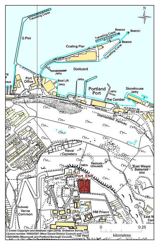
Policy No. Port/EN8 The Verne
Proposals to achieve sustainable re-use of the Verne through the restoration and redevelopment of buildings, will be supported provided that the renovation or alteration of existing buildings and structures is designed sensitively, and with careful regard to the historical and architectural interest and setting.
If any demolition is proposed of buildings which date from the original construction period, robust justification should be provided to demonstrate why these buildings and structures (or parts of) cannot be retained within the scheme.
Any extension or new build should be:
Development proposals should be carefully designed and planned to ensure that no adverse effects on the integrity of European sites occurs as a result of water pollution stemming from site runoff or dust emissions during construction or the operational stage of each of the developments.
7.57 The Verne site referred to in policy Port/EN8 is an area of 0.45ha within the Citadel area that includes four derelict buildings (see Map 9). These were formerly part of the Verne detention centre complex. The site is at the top of a steep hill and isolated from other residential areas. Consequently, it is not within a built-up area boundary and not regarded as a sustainable residential location.
7.58 Although the Verne is not located within a conservation area, the derelict buildings on site, which date from the original period of construction, have a local heritage value. The Verne Citadel Scheduled Monument is located within 30m of the site boundary at its closest point, and several Grade II and II* listed buildings which are associated with this are also located within 300m of the site. Community opinion is that the Verne is something that should be protected, but not as a derelict or under-valued monument. Since the Jailhouse Café first opened, around five years ago, there has been much more awareness of the derelict buildings and their potential, and there is considerable community support for their sensitive redevelopment and suitable re-use.
7.59 The NPPF (para. 184) requires us to conserve heritage assets “in a manner appropriate to their significance”, taking into account the desirability of sustaining and enhancing the significance of heritage assets whilst putting it to viable uses consistent with their conservation. Policy Port/EN8 recognises the heritage value of the site shown on Map 9 and its context and is supportive of development proposals that will realise a unique opportunity to create something appropriate and sustainable, that is not dependent on the proximity of local facilities and services, unless it is part of a larger development scheme. As was concluded by the AECOM site assessment of the Verne35, on its own, it is not a site that is particularly suitable for housing. We would not rule out re-use for residential purposes; a need for key worker housing with the re-opening of the Verne Prison, or a live/work development for instance has some potential. As do enterprise and tourism schemes that show due respect for the heritage of the location and the quality and character of the environment.
7.60 In accordance with the recommendations of the Habitat Regulations Assessment there is the potential for any redevelopment scheme to have a likely significant effect “in combination” on the nearby Isle of Portland to Studland Cliffs SAC through construction-related activities (dust emission), surface water runoff (water quality) and the impact of recreational pressures. In accordance with the recommendations of the HRA, policy Port/EN8 requires any redevelopment scheme to be carefully designed and planned to ensure that no adverse effects on the integrity of European sites occurs either during construction or subsequently.
Policy No. Port/EN9 Public Realm Improvements
Proposals to improve the public realm through the introduction of high quality pavements, signage, street furniture and public art installations will be supported.
Development proposals, where appropriate, should show how they contribute to enhancing the quality of the public realm and the distinct characteristics of their location, with reference to current guidelines.
7.61 The Portland Heritage and Character Assessment of 2017 refers to inadequacies in the quality of the public realm across all the settlement areas of Portland. There are many examples of areas that appear run-down or neglected. The Assessment has also highlighted the fact that too often recent development has used modern materials and lacks an attention to the vernacular and to local character.
7.62 Portland deserves better. The Town Council has accepted that a common palate of materials, street furniture and signage should be further developed and promoted to enhance the quality and legibility of the public realm and distinguish the different characters of individual settlements. It intends commissioning a report that will recommend guidelines as to how this can be achieved. Areas such as the ‘gateways’ at Victoria Square and Heights area, for example, are prime candidates for improvements that can make a strong character statement and set a high standard to be followed in other parts of the Portland.
7.63 The NPPF (para. 91) urges us to “create opportunities for meetings between members of the community who might not otherwise come into contact with each other”. The NPPF (para. 127) says that neighbourhood plans should help “establish a strong sense of place, using streetscapes and buildings to create attractive and comfortable places to live, work and visit”.
7.64 Policy Port/EN9 is supportive of measures to improve the public realm and make them more attractive and usable. It also requires designers of public realm schemes to recognise what is deemed appropriate or tolerable in terms of style, materials, colours etc at different parts of the Island.
15 HCA = Homes and Communities Agency (now 'Homes England')
16 The Land Trust, a national land management charity, Registered Charity No. 1138337
17 Protected under the Ancient Monuments and Archaeological Areas Act of 1979
18 Local Plan para. 2.3.8
19 RIGS = Regionally Important Geological and Geomorphological Site
20 Appraisal of the Conservation Areas of Portland, Weymouth and Portland Borough Council, Mar 2017 https://www.dorsetcouncil.gov.uk/planning-buildings-land/planning/planning-constraints/conservation-areas/weymouth-and-portland/pdfs/appraisal-of-the-conservation-areas-grove-easton-reforne-straits-wakeham-underhill-and-weston-of-portland.pdf
21 Portland Vision, Terence O’Rourke for SW Regional Development Agency, 2008
22 South Devon and Dorset Shoreline Management Plan (SMP2): Durlston Head to Rame Head (June 2011)
23 Portland Town Council used the Local Plan Review to request that Hamm Roundabout (same as Checkpoint) to Fleet to be changed to ‘hold the line’ given the likely impact of breach to Chesil Beach on wider Dorset Coastline. Any such change would need to be considered through a future review of the Shoreline Management Plan
24 National Character Area profile: 137, Isle of Portland, Natural England, 2012
25 Weymouth and Portland Council produced Level 1 and 2 SFRA for the Local Plan, and Dorset County produce a SFRA to support the Minerals and Waste Local Plan.
27 National Character Area profile: 137, Isle of Portland, Natural England, 2012
28 NET = Natural Environment Team
30 Bournemouth, Dorset and Poole ‘Local Transport Plan 3’ 2011-2026
https://www.dorsetforyou.gov.uk/roads-highways-maintenance/roads-and-pavements/documents/ltp3-bournemouth-poole-dorset-strategy-document-final.pdf
31 Weymouth & Portland Local Plan (Saved Policies) - December 2008
32 See BUAB Technical Paper, 2017
https://www.portlandplan.org.uk/wp-content/uploads/2018/03/Portland-Plan-Development-Boundaries-Revisions.pdf
33 As 'saved policies', from previous Local Plan, at December 2008 8
34 Portland Heritage and Character Assessment of 2017, AECOM for Portland Town Council, March 2017 https://www.portlandplan.org.uk/wp-content/uploads/2017/06/PCP-Portland-HCA-low-res.pdf
35 Portland Heritage and Character Assessment of 2017, AECOM for Portland Town Council, March 2017 https://www.portlandplan.org.uk/2017/06/05/major-study-confirms-portlands-unique-character/
< Previous | ^ Top | Next >