
5.1.1 The main route through Tincleton is the east-west link (the C80) which eventually connects to the A35 at Stinsford, and links the B3390 in the adjoining Pallington parish to the east. The north-south link (the C59) provides access to Woodsford and Puddletown (which has the local First and Middle school). The cluster of homes at Clyffe House are served by a private access road. All of the roads are rural in character, typically with hedgerows and/or grass verges and improvised passing places. A network of public footpaths circle the village. The D21305, and old green lane, links north from the centre of the village to the wooded area known as the Hang (and Hardy Way) with a spur to Clyffe House, but as of 2023/24 was impassable and closed on a temporary basis. There is a footpath running south to Watery Lane and on to the River Frome forming part of the extension to the Frome Valley Trail11 .
5.1.2 The main route through West Knighton is Knighton Lane / Highgate Lane (the C82) which runs north-south through the village, and on through Broadmayne to the A352. It connects at its northern end to the C33 that runs from West Stafford, through Lower Lewell and onto Woodsford. Both the Frome Valley Trail and National Cycleway run through the northern end of the parish at Lower Lewell, the Jubilee Trail runs east-west through the southern part of the parish, and the Hardy Trail runs south at Lower Lewell to run down the eastern side of the village before heading west to Warmwell Heath. There are a good number of bridleways as well as public footpaths radiating out from the village in all directions.
5.1.3 Within West Stafford, the main road (the C33) runs to the south side of the village and railway line. It links to the A352 which in turn connects to the A35 to the west. The route through the village has effectively been bypassed by the C33, but is part of the national cycle network (on-road) route. The remaining network of roads in the parish are generally narrow, single track lanes. Public rights of way include an east-west link of footpaths and bridleways linking across fields to Dorchester, and a number of bridleways to the south. The Hardy Way runs from the A352 via bridleways to the western end of the village, and then on roads to Lower Lewell.
5.1.4 Within Woodsford the main road network is composed of an east-west link (the C33 - which is also part of the national cycle network) from Lower Lewell in West Knighton parish to the B3390 in Moreton parish, with a staggered north-south link to Crossways and Tincleton. These routes are typical rural lanes with hedgerows to either side, with generally narrow verges and improvised passing places. A network of public footpaths offers off-road walking routes to and along the River Frome, connecting north to Tincleton (partly along the C59 Watery Lane) and south to Crossways and Moreton Station. The Frome Valley Trail runs through the parish, mainly using the lanes.
5.1.5 It is unlikely that the scale of development within the area will extend the existing road network, although new access points may be created and some businesses – including the quarries beyond the Neighbourhood Plan area – could give rise to significant levels of traffic and the need to improve highway safety, particularly for more vulnerable road users such as walkers, cyclists and horse riders.
5.2.1 Whilst the Neighbourhood Plan has limited options to address traffic and road safety problems, it can help highlight local highway issues that should be considered in transport statements or assessments and consider projects to help reduce known transport / highway safety issues.
5.2.2 Local residents are particularly concerned about speeding through the villages – even those with 30 mph speed limits. Many of the roads in and around the villages do not have separate footways – and these ‘shared’ highways need be (and seem) safe for all users. Tincleton has a community speed watch group and in 2023 installed a Speed Indicating Device (SID). There have been calls for the support for 20mph speed limits in West Stafford where speeding cyclists have also been identified as a particular problem.
5.2.3 As part of the consultations for the Neighbourhood Plan in late 2023, two road safety ideas were put forward for feedback: the ‘Quiet Lanes’ initiative; and traffic calming measures in the villages. Local residents who responded generally supported these proposals, and made further suggestions on limiting access for HGV’s, introducing a speed limit for the length of the National Cycle Route (to 40mph outside of the existing limits), and the need for better hedgerow management.
5.2.4 The term ‘Quiet Lanes’ has been used in other Neighbourhood Plans (including the adjoining Puddletown area) to indicate roads which have low levels of traffic and are important for walking / riding routes (in conjunction with the off-road public right of way network). The term is also used in a legal sense where a Highway Authority can designate part of its highway network as a ‘Quiet Lane’ under the Transport Act and related regulations. Should Dorset Council choose to formally designate the roads as Quiet Lanes, this does not require any physical changes other than appropriate signage to raise awareness of the status of those roads, but measures to encourage motorists to slow down and look out for walkers, cyclists, horse riders and other vulnerable road users can be introduced. In order to avoid confusion, we have adopted the term ‘Quiet, Low Traffic Routes’ for the roads that have been identified through this Plan as routes where walking / riding is particularly important and which ideally should be designated as Quiet Lanes.
5.2.5 Not all planning applications will require a transport statement or assessment, but when these are required by Dorset Council, they should set out, amongst other matters, the likely trip generation and implications for the surrounding highway network12 . In this context, the Neighbourhood Plan seeks to ensure that this includes consideration of how the development may impact on the use of the Quiet, Low Traffic Routes by walkers, cyclists and horse riders.
5.2.6 Any traffic calming or other highway safety measures will need to be designed in a manner appropriate to the rural character of the roads and villages. For example ‘visual narrowing’ where the edge of a street is paved in a different material to the carriageway could reduce visual road width to encourage slower speeds, while still allowing sufficient road width for vehicle accessibility. Pavements within villages, if required, should not use the taller, concrete kerbstones that are more typical of suburban estates. Additional guidance on how to encourage lower speeds in rural environments can be found in the series of documents on the rural roads protocol, traffic in villages and other rural settlements. These are published in the Dorset National Landscape’s resource library https://dorset-nl.org.uk/resource/planning-development/ .
Policy 13. Village roads and Quiet, Low Traffic Routes
Project 2. Improving highway safety on our rural lanes
The Parish Council will request Dorset Council as the Highways Authority to formally designate the network of Quiet, Low Traffic Routes as shown on Map 4 as Quiet Lanes, and manage these accordingly.
The Parish Council will work with Dorset Council as the Highways Authority to identify and where feasible deliver traffic management measures that will address the concerns raised by local residents and businesses. This may include:
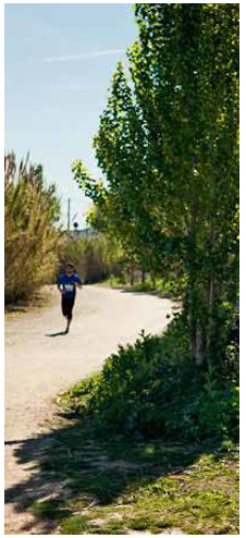
5.3.1 The area has a reasonably good network of public footpaths. There are bridleways in West Knighton and West Stafford, but none in Woodsford and Tincleton. The national cycle network, albeit mainly on-road, runs through the parish. The network of routes could be improved, and developments can create opportunities to achieve good levels of connectivity and encourage walking and cycling for short journeys. In the wider area, there are also opportunities to make better connections that avoid stretches of road where the narrow nature of the lane and traffic speeds makes walking, cycling and horse riding particularly dangerous or off-putting.
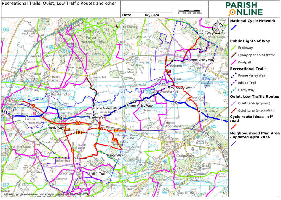
5.3.2 Local residents on the steering group researched possible routes and links that could help address the typical concerns over safety raised by walkers, cyclists and horse riders in the area, and these ideas were consulted on in late 2023. This included promoting a network of roads as Quiet Lanes and improving public rights of way, such as: a new off-road cycle path / bridleway connection from Moreton Station to Watery Lane, at the river Frome Bridge south of Tincleton; connecting the east-west lane (D21320/105 Knighton Heath Barn Lane) which links Highgate Lane to Silverlake to the National Cycle Route 2 at Lower Lewell by using the unclassified road, D21321, and a railway underpass (as an alternative to the much busier C33). This is part of the Hardy Way. These ideas were generally supported and are detailed below. Other ideas were also put forward in response to consultations that have been added where feasible. To avoid cluttering the map only on road cycle paths 1.1, 3.1, 5.1 & 5.2 have been shown. Others could be actively supported as part of the overall traffic calming measures.
Routes |
Work required / general comments / numbers refer to those on map |
|
| 1 | Tincleton to Moreton Station |
This could be in two parts. 1:Upgrade existing farm tracks from the Mill Leat bridge just south of the River Frome to the existing S60/3 footpath to Moreton Station (in the adjoining parish). A footpath is being offered as part of the new quarry application. 1.1. On-road between the Frome Bridge and Tincleton designated as a Quiet Lane. This is part of the Frome Valley Trail and therefore reinforces the importance of its status as a ‘Quiet Lane’. |
| 2 | Tincleton to Tincleton Hang |
This is an unclassified road, D21305, in bad repair. It will eventually be repaired to a standard for cyclists to reach Tolpuddle and Briantspuddle and should be designated as a Quiet Lane. |
| 3 | Knighton Heath Wood / Barn Lane west of Silverlakes to the National Cycle Route 2 at Lower Lewell |
This could be in several parts. 3.2 and 3.3: The proposals for Silverlakes provide an opportunity to extend 3.1 on to Crossways. The potential links are shown as indicated on the Access and Movement plans accompanying the plans for Phase 7 of the development (application reference P/RES/2023/04131). |
| 4 | West Knighton to Crossways |
There is a reopened footpath that links the southwest corner of Silverlakes to the southwest corner of Knighton Heath Wood. Allowing this to be used by horseriders and cyclists would make it much easier to travel off-road to Crossways from West Knighton. There is already a bridleway, S51/2, from the lane west of Silverlakes, 3.1, to West Knighton. |
| 5 | Broadmayne, West Knighton to West Stafford |
The possibility of a cycle path from Broadmayne through West Knighton to join up with the West Stafford by-pass and on to Dorchester has been talked about for a while, as a safer alternative to the A352. Suggested improvements to explore further include: 5.1 and 5.2: designating the adopted highway to the south of the West Stafford by-pass (D21314) as a Quiet Lane. This, together with 5, will link West Knighton to West Stafford and also provide an alternative route to Highgate Lane and on to Crossways (via 3.1, see above). |
| 6 | West Stafford by-pass |
Extending the off-road cycle path (which currently stops at Frome Farm, west of the village) along the West Stafford bypass (which is wide with generous verges) could help provide a more usable link through the area, allowing more direct connections to Dorchester (via 7) and Crossways (via 3.1). There are two options: 6.1: continue eastwards all the way to Highgate Lane. |
| 7 | West Stafford to Dorchester |
Improving the surface of the bridleway between Frome Cottage to St Georges Road (S52/8), and reducing the number of gates to accommodate cyclists and walkers, could make this a popular route. |
| NCN2 | National Cycle Network 2 |
This route should be designated as a Quiet Lane. It coincides with significant on-road sections of both the Hardy Way and (proposed) Frome Valley Way. |
5.3.3 Whilst some of these routes may be aspirational, they would be of real benefit to local residents, improving links to adjoining settlements as well as better access to the countryside for recreation.
5.3.4 The actual alignment, surfacing and changes to existing gates, signage etc would be subject to negotiation with the appropriate landowners. Ideally routes should be a minimum of 2m wide, segregated from the highway where possible. Signage should relate well to the rural setting - traditional black wording on white background finger posts are quite common for roads in Knightsford and would also be an appropriate design. Additional measures may also be needed such as fencing / hedging to ensure that increased public access does not interfere with farming activities. Stiles should be replaced by gates, particularly where footpaths meet a road, as this will improve safety and accessibility for less able residents and residents with buggies, pushchairs, prams etc. The extent to which all routes can be inclusive will be cost dependent.
5.3.5 All of this will also be dependent on funding. However development on land where these routes are proposed, or where mitigation measures are required to address the transport impacts of development, may mean that these projects could come forward as part of the development package.
Policy 14. Prioritising walking, cycling and horse riding
Project 3. Improvements to the network of footpaths, bridleways and cycle routes
The Parish Council will work with local landowners and Dorset Council as the Highways Authority, in consultation with local residents, to bring forward improvements to the network of footpaths, bridleways and cycle routes described in Table 3, as funding and resources permit.
11 The route for the section of the trail from Dorchester to Poole Harbour has been agreed by Dorset Council, but has yet to be signposted.
12 Dorset Council’s Validation checklist (October 2022) https://www.dorsetcouncil.gov.uk/documents/d/guest/new-validation-checklist-v16-final-updated-22-08-2024 provides guidance on the coverage and detail of the transport assessment/statements. For smaller schemes, the assessment is expected to outline the transport aspects of the application including: the expected trip generation and implications on the surrounding highway network; access to public transport; expected impacts on parking; and provision of car or cycle parking.
< Previous | ^ Top | Next >