
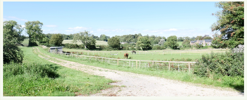
4.1.1 Knightsford parish has a strong rural landscape and rich vegetation, and our residents enjoy immediate access to the unspoilt surrounding countryside. All four parishes have long distance views and areas of deciduous woodland, including two areas of ancient woodland, Napiers Copse and parts of Clyffe Copse in Tincleton known as the Hang.
4.1.2 An assessment of the landscape character of the area in Dorset is available online3. The main landscapes are the valley pasture landscape running along the valley of the River Frome, and the heath / farm mosaic that covers much of the area along and to the south of the railway line. Key characteristics of these two landscape types include:
Valley pasture
Heath / farmland mosaic
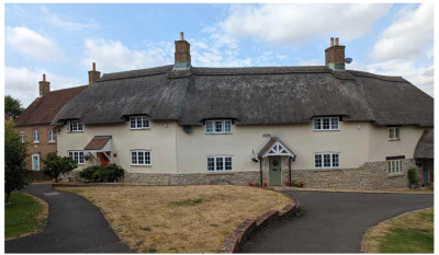
4.1.3 The northern part of the area around Tincleton and Woodsford enjoys particularly dark skies and a general lack of light pollution4. Whilst street lighting is not envisaged in our area, it may be necessary to provide some lighting along foot/cycle paths, and external lighting for safety / security reasons. Dorset Council’s guidance for rural areas outside of National Landscapes5 suggests our area should be treated as Environmental Zone 2, which means that upward light spillage should be prevented, and the CCT (the correlated colour temperature of any external lighting) should ideally not exceed 3000K (avoiding the cooler, bluer tones of higher CCT values, which are less tolerated by nocturnal wildlife). Low-level solutions such as solar cat’s eye lighting and down-lighting along paths (either wall-mounted or on posts) are likely to be in harmony with the surrounding rural landscape. The use of PIR (passive infrared) or similar technologies that detect motion and enable lighting to be automatically reduced or switched off when not required can help minimise the impact on dark night skies and should also be considered.
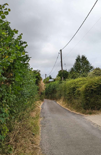
4.1.4 The rural character of the lanes is an important characteristic of the area, and these are typically lined with thick hedges and lack pavements. Where measures are required to improve highway safety, the design should seek to reflect the area’s rural character. This may, for example, be through separating any pedestrian / cycle routes through a grassed verge rather than an engineered kerb.
4.1.5 It is important that development recognises the intrinsic character and beauty of the countryside, and aims to enhance it. General principles to achieve this are therefore included in the following policy.
Policy 1. Development set in rural landscapes
Development should:
4.2.1 The broadleaved woodlands, copses and native hedgerows, together with the habitats associated with the floodplain and drainage channels of the River Frome, provide important wildlife corridors through our landscape, as well as contributing to its landscape character. Around the villages, wildlife can also be found in our gardens and green spaces, including our churchyards. Each element plays its role in enhancing the rural feel of the area, improving the aesthetics of the environment and facilitating the movement of species.
4.2.2 Under the wider backdrop of climate change and global warming, protection of biodiversity is becoming an important priority and should start at the local level. Biodiversity has multiple benefits as it can protect the natural environment, provide opportunities to educate and involve the community in looking after features in their area, and even boost health and well-being and benefit the local economy. Where feasible, public access to wildlife areas is encouraged, providing that this will not unduly disturb protected species.
4.2.3 National and Local Plan policies already provide protection of the nationally and locally important wildlife sites in our area. The Environment Act (2021) contains provisions for the protection and improvement of the environment, including introducing biodiversity net gain as a statutory requirement. This will provide a mechanism to assess the value of habitats that may be lost as a result of development, and require a plan (either on-site or through off-site measures) to achieve a minimum 10% increase in overall biodiversity. Some minor developments, such as householder applications and changes of use, are exempt from the requirements. The Dorset Biodiversity Appraisal Protocol offers general guidance as well as specific requirements for new development in order to meet biodiversity aims, and will be updated as the requirements of the Environment Act come into force.
4.2.4 Guidance for incorporating wildlife features within villages is contained in Policy 9. The following policy considers the wider opportunities for enhancing the biodiversity of wildlife areas across all four parishes.
4.2.5 In general, where landscaping / planting proposals are considered necessary, details of the mix of species and maintenance schedule will be made as planning conditions. The Government expect the planting associated with any biodiversity net gain to be maintained for a minimum of 30 years, and a similar timespan is considered appropriate for landscaping where such planting is deemed necessary to make a development acceptable.
4.2.6 In our area, Ash dieback could have a significant impact on landscape character. While the policies in this Plan cannot be used to address the loss of such trees (other than when tree planting may be needed to mitigate a direct impact from development), a project has been suggested for the Parish Council to consider. This would mean using some of the precept and any available grant funding to encourage replacement planting with dieback tolerant trees.
Policy 2. Wildlife corridors and biodiversity
Project 1. Tree Planting
The Parish Council will explore setting up a grant scheme to encourage the replacement planting of diseased / dead ash trees with new, dieback tolerant species.
4.3.1 The overwhelming priority expressed by local residents in terms of design, was to retain the individual, rural and historic character of each of our villages and hamlets. There was also general consensus that development should:
4.3.2 Given the rural nature of the Neighbourhood Plan area, the level of development that is likely to take place will be small-scale, reflective of historic growth patterns, rather than creating suburban estates that are not in keeping with the rural nature of our villages. There is much variety across the four villages that has resulted in a strong local character and visual interest for each village. The different qualities of street layout, building setbacks, lines, plot sizes and widths, and levels of enclosure need to be taken into consideration in new design proposals. New development should complement or, where appropriate, seek to enrich the streetscape in a manner compatible with that village’s character. Where there are areas of 20th century, more suburban style, development, there may be opportunities to reduce the obvious repetition and create visual interest in a manner that does not unduly jar with the established character of that area.
4.3.3 In order to understand the individual, rural and historic character of each of our villages and hamlets which our residents wish to conserve, the Neighbourhood Plan Group worked with AECOM 6 to develop design guidance, and the descriptions of the four areas are summarised in Appendix 3 and have helped inform the policies that follow. It is expected that proposals for development will have regard to the design guidance advice contained in the Knightsford Area-wide design guidance and codes: April 2023.
4.3.4 Design and access statements are often required to accompany planning applications, and should be used to demonstrate a good understanding of:
Plot formation, building set-back, orientation and boundary treatments
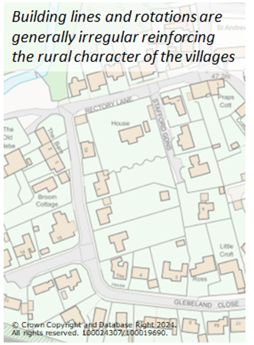
4.3.5 Plots and building lines within the villages are generally irregular, with variations on how buildings are set back from and face onto the lanes. This is considered to be a key aspect of the rural character of the area, and should be introduced within the areas of more uniform 20th century development where opportunities arise.
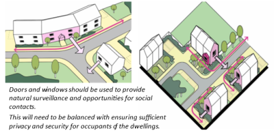
4.3.6 The interaction of buildings and front garden areas with the lanes and open spaces provides opportunities for natural surveillance (keeping crime rates low), as well as opportunities for social interaction (as people have opportunities to recognise each other and talk). This is only achieved where the doors and windows open out onto the street, and any boundary treatments are low level.
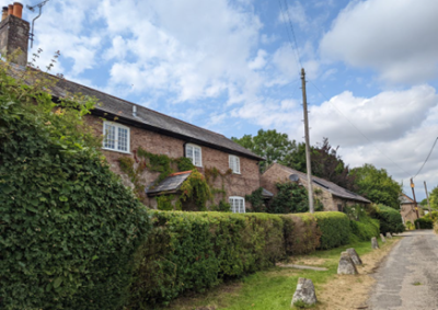
4.3.7 Boundary treatments are mainly natural (hedgerows and verges), but there are also examples of low-height brick walls, stone / rubble walls, railings, and wooden post and rail / picket fencing. The vegetation contributes to the rural character of the area and the low level brick and stone walls, and open wooden fencing provides opportunities for social interaction between the front gardens and the street, as well as helping define the street or pathway. Close-boarded panel fencing, high walls, and the use of concrete or other materials not prevalent in the area, should be avoided as they are neither in keeping with the area or help create friendly streets. Similarly, the boundary treatment with the open countryside should be mainly hedges, shrubs and trees, providing a buffer zone between the site and the countryside to reduce the urban influence of the development in wider views, and create a wildlife corridor along this new edge.
4.3.8 Together with the creation of potential local landmarks, one of the crucial aspects of a successful streetscape is the issue of corners created by junctions. Buildings on these junctions tend to have at least two public facing façades, and as a place where people often stop to negotiate the junction, also have more influence on the street’s appearance. The irregular nature of the street pattern in our area means that such corners are not always 90 degrees, and this in itself can add to the local character by creating designs / forms that are more unusual, such as Floyers Field in West Stafford, where the building aligns with the curving nature of the street corner, providing a positive front and natural surveillance from all of the façade.
Policy 3. Plot formation, building set-back, orientation and boundary treatments
Development should complement and, where appropriate, enrich the streetscape into which it will be inserted. To achieve this, the following principles should be adhered to in considering plot formation, building set-back, orientation and boundary treatments:
4.3.9 Car ownership levels are higher than average7, and are likely to remain high, as many of the day-to-day journeys will be outside of the Neighbourhood Plan area and public transport options are poor.
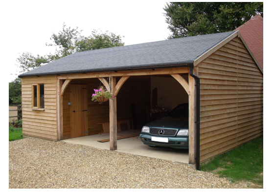
4.3.10 The dominant car parking typology found in the parish is on-plot parking, generally to the front or side of the property, but there are also examples where parking is provided to the rear or within garages. Parking courts are not typical of the area and are not encouraged.
4.3.11 It is important to consider the placement and design of car parking within developments, to avoid vehicles dominating the streetscape, or increasing on-street parking on our village lanes which are often of insufficient width (one example being along Highgate Lane in West Knighton due to the lack of on-plot parking), or the removal of front gardens and associated vegetation to provide off-road spaces. Garages are often used for additional storage, and therefore consideration needs to be given to the fact that cars may then still be parked elsewhere – whether in front of the garage or on the street. Where placed to the side, they can also close the gaps between buildings which can be detrimental to local character. Where garaging is needed, the use of more open car barns can ensure that the vehicle space is not re-purposed for storage, but consideration will also be needed to ensure good natural surveillance from nearby buildings to avoid creating opportunities for theft or other anti-social behaviour. Similarly, any hardstanding areas for parked vehicles should have good natural surveillance from the property they serve. Should open car ports or barns be considered, then advice can be sought from Dorset Police’s Secured by Design Officer. The inclusion of secure provision for cycle and waste bin storage should also be considered, either within or separate to the garaging.
4.3.12 Dorset Council have set out what they consider to be the optimum parking standards8, and these will be the starting point for considering if a development is providing adequate provision. For small sites of up to 5 dwellings, the guidance advises that 1 parking space is provided for any 1 bedroom dwelling, 1 or 2 spaces for 2 bedroom dwellings, 2 spaces for 3 bedroom dwellings and 2 or 3 spaces for larger dwellings, together with 1 visitor space. Spaces within car ports and car barns are counted in the supply, with spaces in garages discounted by ½ as these tend to be less well used.
4.3.13 With the growing take-up of electric cars, building Regulations now require electric car charging points to be provided for all new houses. In the absence of a garage or car barn, the charging points will generally be placed on the wall of the house closest to the parking space, and can harm the character of the house if not given careful consideration.
Policy 4. Incorporating the car in developments – parking guidelines
4.3.14 The density of development within the parishes is quite low, reflecting its rural character and the influence of front and rear gardens of varying sizes.
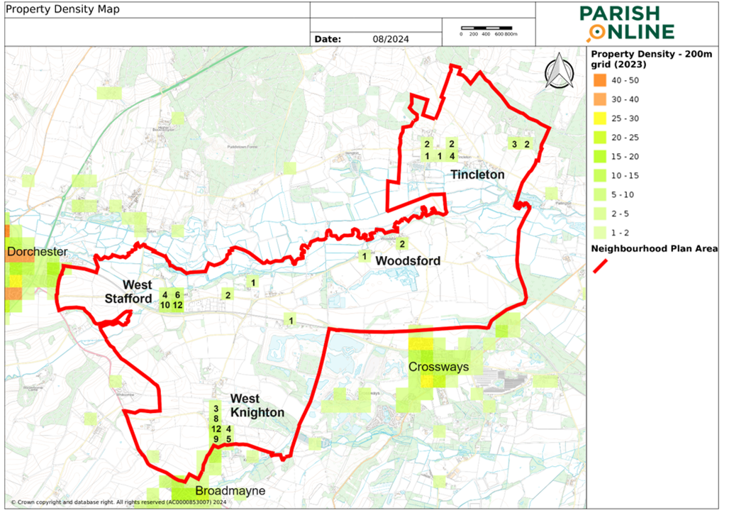
4.3.15 Building densities in smaller and more scattered villages of Woodsford and Tincleton are generally much lower than in West Knighton and West Stafford, but even in those villages the density barely reaches 12 dwellings per hectare (dph). In comparison, the larger settlements of Crossways include areas of around 28dph, with the county town of Dorchester having some areas where the density exceeds 50dph.
4.3.16 Whilst infill development will inevitably increase building densities, it is important that this does not result in the closure of gaps and views between properties that are important elements of that village’s character.
4.3.17 Properties tend to be between 1–2 storeys high, with the storey height being relatively low on many of the workers' cottages, often with rooms in the roof (i.e. 1½ storeys). Churches are the tallest elements in the landscape. Whilst there are manor and other grander houses of 2½ to 3 storeys (such as at Stafford House, Talbothayes Lodge, Lower Lewell Farmhouse, Woodsford Castle, and Clyffe Manor House), there are very few examples within the villages themselves (Manor House at West Stafford, Woodsford Manor and Woodsford House) which are taller than 2 storeys within the villages. It is also important to consider the actual heights within each storey and the height of the roof, as if these are much greater than typical for the area, it can look out of place.
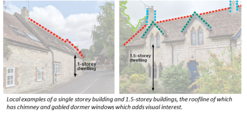
4.3.18 Rooflines are generally irregular and interrupted by the gaps between buildings. Chimneys and dormers often decorate the roofs of domestic properties, offering visual interest. The undulating topography in some villages, especially West Stafford and West Knighton, adds further interest to the roofline and creates good perspective views.
Policy 5. Density, building heights and rooflines
Development should complement and, where appropriate, enrich the streetscape into which it will be inserted. To achieve this, the following principles should be adhered to in considering density, building heights and mix:
4.3.19 The current mix of housing in the village includes bungalows, detached and semi-detached houses, terraces, and converted farm buildings. In order to retain this mix so that the villages can accommodate the varied housing needs of a thriving community, new development should offer a range of building types and sizes.
Policy 6. Building mix
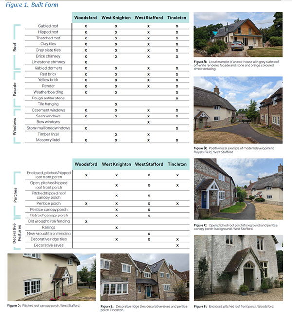
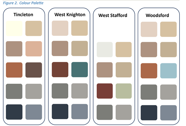
4.3.20 The materials used in many of the older buildings in the villages reflect the building materials that were locally available at that time. They create a distinctive local colour palette that we wish to retain to help reinforce the local nature of our villages. Whilst some of these traditional building materials may no longer be available (for example, Broadmayne brickworks no longer exists, and only reclaimed bricks are now available), complementary materials can be sourced that use the same colour palette and should therefore help new buildings or extensions integrate more successfully. The following tables summarise the commonly recurring forms, features and materials seen across the four villages (as marked with ‘X’), together with a diagram indicating the approximate colour palette found in each village.
4.3.21 Key local materials and architectural features include, but are not limited to, red and buff brick, cob/render, stone rubble, local pale Purbeck and Portland limestones, thatch or clay tile for roofs with brick chimney stacks, masonry or timber lintels and sills, and drip moulding (over windows and doorways to protect the area below from rainwater). Information on traditional local building stone, produced by Historic England, can be found at https://cms.historicengland.org.uk/images-books/publications/building-stones-england-dorset/ .
4.3.22 The choice of colour and finish of materials is also an important consideration in reducing the impact of the buildings on the surrounding landscape. Generally very light colours, like white, cream or light grey, and large areas of intense strong colours do not blend well with the rural landscape, whereas muted and darker tones can be less intrusive.
4.3.23 Natural materials tend to weather well, have better eco-credentials (particularly if these can be locally sourced), and over time develop subtle variations in colour and texture that reflects the wider environment and landscape. In contrast, man-made synthetic, pre-coloured materials tend to lack the variation of colour and texture found in natural materials and do not weather well, and as such are less likely to blend into the streetscape.
Policy 7. Materials and architectural details
Development should complement and, where appropriate, enrich the streetscape into which it will be inserted. To achieve this, the following principles should be adhered to in considering the built forms, materials and architectural details used:
4.3.24 It is important that extensions and alterations, including conversions, are designed to preserve the character and appearance of the original building itself, as well as the street scene within which it sits. The pitch and form of a building’s roof forms part of its character; materials, architectural features and the proportions of the original building also need careful consideration to ensure that the alterations complement these existing elements. As a general rule, they should not be visually dominant or taller than the existing building.
4.3.25 Other considerations include the need to safeguard the privacy and daylight amenity of neighbouring properties (which is covered through the Local Plan policies), and retain sufficient on-site parking and private amenity (garden) area.
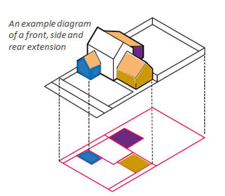
4.3.26 Forward extensions are difficult to design successfully, and they tend to overwhelm the original building form. Single-storey and double storey side extensions may be more feasible, but should be set back from the main building, complement its materials and detailing, while the roof of the extension should harmonise with that of the original building. It will be important to retain the spaces around the building where these reinforce the character of the area by providing views and a feeling of spaciousness. Single storey rear extensions are generally the easiest way to extend a property, although care may be needed to minimise any effects on neighbouring properties, such as blocking daylight. Double storey rear extensions may be possible, and the roof form and pitch should reflect the original building and sit slightly lower than the main ridge of the building. Upward extensions should be sensitive to the surrounding rooflines.
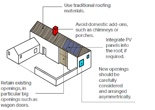
4.3.27 Farmsteads were a dominant feature of the Neighbourhood Plan area and mainly developed by the end of the 17th century. Over time, a number of the farm buildings have become redundant, and these have potential to be converted to alternative uses, whether for new homes or businesses. These often have interesting features that remind us of the past use of the building, and the history of our parish – for example, openings or wagon doors, and the courtyard style arrangement of buildings.
Policy 8. Extensions and conversions – general principles
4.3.28 There are a range of factors that can help ensure that the buildings we create today are less resource intensive and less damaging to our environment. This includes:
4.3.29 Central Government is using Building Regulations and legislation to improve energy efficiency, drainage and biodiversity. Such measures are coming into effect, such as the Future Homes Standards which should achieve a 75–80% reduction in carbon emissions from new homes from 2025 (and similar measures being considered for non-domestic properties), and biodiversity net gain requirements that will ensure building developments create more wildlife habitats than they destroy, starting from 2024.
4.3.30 It is therefore important that these considerations are factored in from the very start of the design, as they can impact on the appearance and effectiveness of the development, and are generally cheaper to design in rather than retrofit.
4.3.31 Woodsford and Tincleton villages are not on mains drains, while West Knighton and West Stafford are. The area drains towards the River Frome, which in turn drains into Poole Harbour, both of these are of great importance for wildlife. It is crucial that development uses drainage systems that do not result in an increase in nutrients going into the Frome.
4.3.32 The most effective type or design of SuDS will depend on site-specific conditions including the underlying ground conditions and infiltration rate (much of the area is susceptible to groundwater flood risk – see Appendix 2). Some SuDS are vegetated, using natural processes to slow and clean the water. These should be favoured where there is sufficient space and the conditions are right, as they will also support wildlife and enhance the rural character of our area.
4.3.33 Rainwater harvesting (systems that capture and store rainwater and/or the reuse of grey water, such as from baths and washing machines) can help reduce demand on our water resources, and lessen the amount of water going into our drains. Simple storage solutions, such as water butts, can help provide significant reduction. Larger systems may be better using underground storage tanks to enable the more efficient use of land, and as such are best considered early in the process.
4.3.34 Most forms of development include footpaths, driveways, car parking spaces and other hardstanding that, unless permeable, will increase the risks of surface water flooding. Whilst the underlying ground conditions can lead to waterlogged soils, ensuring new surfaces are permeable will nonetheless be effective for much of the year, and reduce the risk of flash floods. This could include:
4.3.35 Thermal mass and insulation are critical to achieving more energy efficient buildings, and can generally be achieved without impacting on the external appearance. Some traditional materials such as cob walls, if used, may need to be adapted to achieve the levels of thermal efficiency required by Building Regulations. Brick, stone (as a facing), and timber construction are likely to be able to achieve higher standards.
4.3.36 Solar gain, daylight and sun penetration also contribute significantly to a building’s energy efficiency, although care needs to be taken to avoid overheating. In principle, the main glazed elevations should be within 30° due south to benefit from solar heat gain, but whether this is possible will also depend on the topography, the relationship of the building with the highway, proximity to neighbouring buildings, and local character. Consideration should also be given to the potential for overheating, and how this can be reduced: options include longer roof overhangs and deep window reveals (as opposed to using external louvres / shutters that are not typically found in the area) to provide shading in hotter summer months. Conversely, north-facing facades should reduce large areas of glazing to minimise heat loss on this cooler side.
4.3.37 The use of renewable / low carbon energy solutions such as air and ground source heat pumps and solar panels are strongly encouraged. District heat networks can play an important role in the transition to low carbon energy, and would be more efficient than individual heating systems and generate less carbon emissions, but the limited scale of new development in our area means that such systems are unlikely to be viable.
4.3.38 Air source heat pumps require the unit to be placed outside, and therefore should be considered in the design. They do not tend to be noisy (modern heat pumps make about as much noise as a refrigerator). Ground source heat pumps typically need more outside space (albeit underground) to allow the installation of the pipes, which can either be installed vertically or horizontally. Vertical installation will depend on the ground conditions – for example, high groundwater flows and soft clays should be avoided9.
4.3.39 The design and installation of solar panels will need to be done carefully given the historic character of much of our area. These can be more successfully integrated if considered as part of the design, as less intrusive options include solar shingles and photovoltaic slates; using black solar panels with black mounting systems and frames.
4.3.40 Not all renewable / low carbon energy measures require planning permission, and there may be other options that can be considered, such as the use of hydrotreated vegetable oil (HVO) in boilers as an alternative to heating oil.
4.3.41 New buildings, extensions and alterations provide opportunities to build in features that can support local wildlife. This can be in the form of bat and bird boxes, swift bricks, bee bricks. Other wildlife such as hedgehogs can also be encouraged into garden areas, with composting piles, and making sure that there are gaps or holes in boundary walls / fences to let them come and go.
4.3.42 In January 2024 Dorset Council introduced a requirement for planning applications proposing new or replacement buildings to include a completed sustainability checklist. This includes matters such as reducing energy consumption, the use of sustainable materials, waste reduction and recycling, sustainable drainage, and incorporating green infrastructure. The following policy requirements should be referenced in completing this checklist.
Policy 9. Sustainability in design
4.4.1 National planning policy allows for green spaces that are local in character, well related to an existing settlement, and which are of local value and significance (for example due to their landscape, recreation or historic / cultural interest) to be designated as “Local Green Spaces”. This designation provides strong protection against development (similar to Green Belt policies). Such spaces can be in public or private ownership, and designation does not convey any new public access rights or management responsibilities. Like Green Belts, the designation is expected to last well beyond the Neighbourhood Plan period, and therefore it is important to consider whether the land may need to be developed in the longer term, prior to designation. In our area, the Local Plan policies and allocations do not envisage any large-scale housing or employment requirements that would be prevented by Local Green Space designation. Major development is envisaged in the form of minerals workings, but the policies in this Plan cannot influence planning decisions on such workings, as these minerals and waste matters fall outside the remit of Neighbourhood Planning.
4.4.2 Three Local Green Spaces have been confirmed in our area, one in West Knighton and two in West Stafford, as described in the following table:
|
Knighton Village Green and Playpark Located between Knighton Lane, Glebe Way and Lewell Way. 
|
Approx 0.7ha in size, owned by Magna Housing. This is an important recreation area for the village, as well as providing a focal point for the late 20th century development on the southern edge of the village. 
|
|
West Stafford Play Area Located west of Glebeland Close and also accessed from the track joining to the corner of Rectory Lane (part of the Hardy Way). 
|
Approx 0.12ha in size, owned by West Stafford Village Hall. This is an important, accessible recreation area for the village, run by local residents through the WSVH charity, and funded by the precept. The play equipment spans across all age groups from babies / toddlers to teenagers. 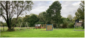
|
|
The Green, West Stafford Located to the north side of Glebeland Close, in Flogers Field. 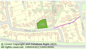
|
Approx 0.11ha in size, owned by Knightsford Parish Council. This is a quiet green space within the centre of the village, set aside as public open space and used for events such as the ‘Coronation Party’. 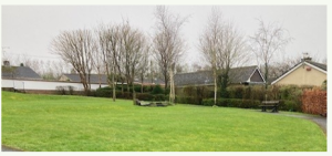
|
Policy 10. Local Green Spaces
The following local green spaces should be protected. Inappropriate development that would harm their character and reason for designation, as set out in Table 1, will not be permitted, other than in very special circumstances:
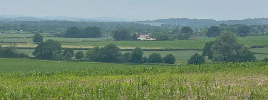
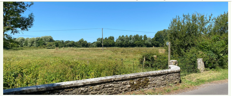
4.5.1 Most of the views cited by local residents as important to them, are within the countryside rather than the built-up areas of each village. This is probably in part due to the extensive network of footpaths and bridleways crossing our area, and rural lanes that are used by walkers, cyclists and horse riders. The following local landmarks, views, and sequence of views, have been identified as particularly important, and their location are indicated in the maps in Appendix 4:
Tincleton
The long, straight nature of the road east west through the parish offers provides a sequence of views and understanding of the scattered nature of the village with its green gaps between the clusters of development. St John’s Church and the Old School stand out as important local landmarks – the view of these buildings from the western approach (T-V1) being particularly noteworthy.
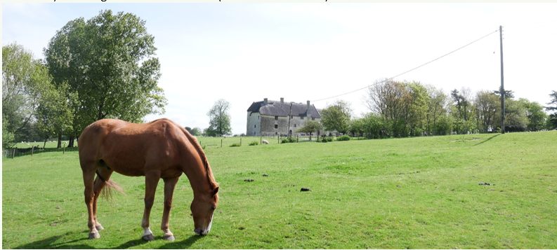
The views from the same road, looking north towards the local landmark of Clyffe House, including through the entrance pillars as well as directly from the south (T-V2). In these views, the house appears in isolation, projecting above the trees.
There are also long-distance, panoramic views looking south across the River Frome valley, seen from the network of footpaths to the north of the village (such as from T-V3 and T-V4). These are perhaps most notable when coming from Tincleton Hang / Clyffe Copse, where the open views contrast strongly with the more enclosed nature of views from within the wooded areas.
West Knighton
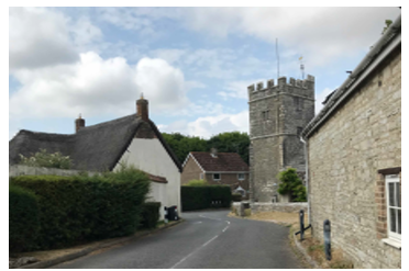
There is a sequence of attractive views through the historic core of the village travelling in both directions between the northern end of the village and junction with Loscombe Lane (WK-V1). These are formed by the various historic buildings along Highgate Lane, a number of which are noted in the Conservation Area appraisal, and glimpses out to the wider countryside via the gaps and tracks leading off the lane. St Peter’s Church and the New Inn are obvious local landmarks.
There are also much valued, long-distance views across the open fields surrounding the village – such as the sequence of views experienced from the public footpath to the west of the village (WK-V2) including from the junction with Loscombe Lane and along the Jubilee Trail, looking over fields towards the village.
West Stafford
There are many long-distance views towards open fields generated along the rural lanes outside the village settlement. Stafford House with its parkland setting is a local landmark, and there are views of this from the west (travelling along Bockhampton Lane) across farmland (such as WS-V1), as well as the south-west approach where the parkland borders are marked by the metal railings (such as WS-V2).
The views of the river and water meadows are also noted in the Conservation Area Appraisal, particularly from the bridge south of Stafford House (the traditional stone-built bridge is mentioned in Thomas Hardy’s ‘Tess’) where you exit from the village, but also from the ends of Rectory Lane and Manor Drive (WS-V3, looking west and through the gate to the east – depending on the degree of roadside vegetation at that time).
Whilst there are limited views of St Andrew’s Church away from the settlement, it is an important local landmark, together with the grouping of the Village Hall and Wise Man Inn, as seen in views travelling through the village (such as indicated by WS-V4). The entrance into the village from the north is framed by stone bridge and tunnelled vegetation (WS-V5). The Conservation Area appraisal also notes the glimpses out, into Barton Close, along Rectory Lane, and down to the river and Manor House.
Woodsford
There are various attractive, long-distance views to the north of the parish, created by the open nature of the landscape and presence of the River Frome. One such example is the view from the stone bridge on Watery Lane, looking east (W-V1).
There are also views from the road and local footpaths (in particular S39/57) of The Castle, a local landmark, standing in relative isolation (such as from W-V2).
Policy 11. Important local views and landmarks
Locally valued views, as described in Table 2, are to be respected. Development that would significantly degrade these views and significance of local landmarks, by virtue of scale, massing, design or poor location, will be resisted.
4.6.1 There are many Listed Buildings in our area, but also many important unlisted historic buildings and features. The unlisted historic buildings and structures (non-designated heritage assets) contribute to the character of the area, and are identified in the Conservation Area appraisals and Dorset Historic Environment Record (HER), and Dorset Council is in the process of compiling a ‘local list’ of such features. An example of a non-designated heritage asset would be the WWII pill box to the south of Frome Bridge, in Woodsford parish. Another example is the historic barn at Glebe Farm in West Knighton, with its half-hip metal roof over older slates, and four loop lights in the gable end.
4.6.2 In the past, the impact of development on these historic buildings and their importance in the streetscene has not always been well-considered.
4.6.3 One such example is the late 20th century house in the centre of the view along the main thoroughfare in West Stafford is an example of where little thought appears to have been given to how this would impact on the approach to the church – whilst clear views of the church are maintained, the property is central in the view along the street, and the style and materials used jar with the village’s historic character.
4.6.4 Another example is the case of Woodsford Castle. The setting of this castle has been much debated in relation to the quarrying proposals in the wider area. Historic England helpfully advised that, whilst the views to and from the building within its surroundings were important, it was also important to consider how the open and rural landscape has contributed to its significance, recognising how it would have been experienced in late medieval times when it was built with defensive capabilities10.
4.6.5 The following policy expands on the general protection given to these heritage assets under national planning policy (whether designated or not), highlighting the importance of ensuring that our historic buildings and features are not overwhelmed or otherwise harmed by new development, and, where possible, that development is designed to raise people’s awareness and understanding of our area’s history.
Policy 12. Development in proximity to heritage assets
New development in proximity to a heritage asset should look to minimise harm to its significance in line with national planning policy, and where feasible and appropriate, raise awareness of that asset, through consideration of:
3 https://www.dorsetcouncil.gov.uk/countryside-coast-parks/the-dorset-landscape/the-dorset-landscape For the broader national character area profiles please see the Dorset Heaths area (NCA Profile:135
http://publications.naturalengland.org.uk/publication/6271645295575040?category=587130) Fand the Dorset Downs and Cranborne Chase area (NCA Profile:134
http://publications.naturalengland.org.uk/publication/5846213517639680?category=587130) which covers the western part including West Stafford and the western side of West Knighton.
4 https://nightblight.cpre.org.uk/maps/
5 https://www.dorsetcouncil.gov.uk/-/street-lighting-and-illuminated-signs-policy#lighting-provision
6 AECOM is a national environmental and planning consultancy funded through Government Neighbourhood Plan support
7 The 2021 Census shows that 63% of households in Knightsford had 2 or more vehicles (compared to the Dorset average of 45%) and far fewer had no vehicle (7% compared to 14%)
8 Residential Car Parking Provision – Local Guidance for Dorset, May 2011 https://www.dorsetcouncil.gov.uk/-/car-and-cycle-parking-standards
9 Information sourced from https://www.theecoexperts.co.uk/
10 for further information please refer to the response from Historic England dated 23/11/23 to P/FUL/2023/04753, P/VOC/2023/04761 & P/VOC/2023/04760 which can be found at https://planning.dorsetcouncil.gov.uk/plandisp.aspx?recno=399138
< Previous | ^ Top | Next >