
To protect and enhance the natural, agricultural and built environment of the Parish including its landscape, built heritage, archaeological sites and wildlife habitats. To keep development to an agreed scale, of good quality and design, making use of materials that are appropriate, sustainable and complementary to neighbouring properties. To reduce vulnerability to the impact of severe weather i.e. flooding, etc. |
The parish’s landscape is predominantly rural and agricultural. The gently undulating topography and gaps in the roadside hedgerows and the village’s linear layout with gaps between buildings ensures that residents have extensive views over the near countryside, as well as more distant views towards local features such as Bulbarrow or Dungeon Hill, and across The Borough towards Bishops Caundle. The parish’s network of footpaths also provides access to views of the surrounding countryside, while many residents enjoy unspoilt views from the privacy of their own homes and gardens.
Some of the most notable views across the countryside are available to travellers along the following roads. These views contribute significantly both to the area’s special character and to the quality of life enjoyed by its residents. In certain circumstances, development could positively enhance local views, such as through the removal or screening of incongruous structures or the removal of features that block a view (providing that those features are not of importance in their own right). Where built development is proposed within an identified view, then a Landscape and Visual Impact Assessment (LVIA) including photomontages should be produced as part of the application to ensure the impact of the development is understood and that measures are identified to ensure the view is not diminished.
The following views are particularly notable for their scenic quality and for their value in enhancing Holwell’s intensely rural setting:
Table 1 – Locally Important Views
| Ref | Location and Direction | View Description |
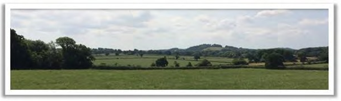
| View 1 towards Bulbarrow | From various locations along Packers Hill. | Panoramic view across farmland, woods and open countryside towards the ridge of Bulbarrow in the distance. |
| View 2 towards Dungeon Hill | From various locations within Holwell, notably on Pulham Road, looking south west. | Panoramic view over farmland and wooded areas towards distant hills. |
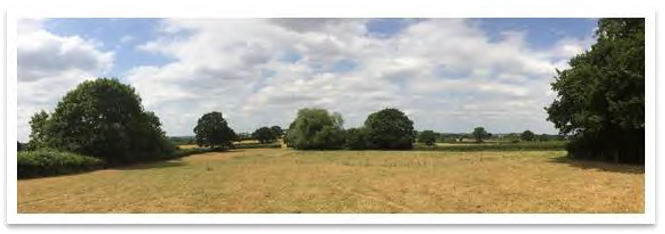
| View 3 towards Bishops Caundle | From Crouch Lane and particularly footpaths north of Penny Farm, looking north. | Panoramic view over farmland and wooded areas towards the village of Bishops Caundle on the other side of the valley. Views of the Grade I Church of St Laurence in the mid-ground. |
View 1 from Packers Hill towards Bulbarrow
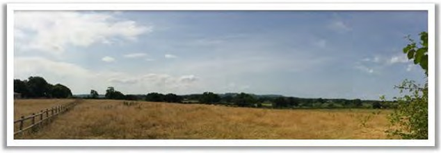
View 2 from Pulham Road towards Dungeon Hill
View 3 Footpath behind Penny Lane looking north towards Bishops Caundle
Policy E1: Locally Important Views
The design and layout of development should minimise adverse impacts on views from public rights of way over open countryside and preserve and enhance such views where possible.
Development that would adversely affect the rural setting of the village [whether by scale, massing, design or location] will not be supported.
In a rural community like Holwell, well over 90% of land cover is used for agricultural land. A number of areas have been identified as of particular landscape, cultural or wildlife value. There are four Sites of Nature Conservation Interest (SNCI) within the Neighbourhood Plan area. These are
These have management plans designated by the Dorset Wildlife Trust and planning decisions are required to take them into account. Two of these have adjoining areas which are also of potential wildlife importance. Firstly Peaceful Lane on the western side from the northern end of the SNCI to its junction with the A3030 contains many snowdrops and interestingly, at the Stony Lane junction, Box Buxus sempervirens forms part of the hedge. Secondly, on Holwell Drove, to the east of the SNCI on its northern side, there is a narrow strip of woodland where Common-spotted Orchids and Moschatel both grow.
There is land at Barnes Cross that relates to the historically interesting post box. The verges contain many Common-spotted Orchids. These grow by the hedge on its south-east side between Crouch Hill Lane and Stock Hill Lane although the vegetation here is becoming somewhat rough. In the triangle formed by the lanes there is a Wild Service Tree Sorbus torminalis planted by the Parish Council and just south at the first corner in Stock Hill Lane a nightingale was heard singing in the thicket on the left.
Holwell churchyard has a number of interesting plant species. Among the flowers, as well as snowdrops and primroses, wild daffodil, Narcissus pseudonarcissus and Fritillary Fritillaria meleagris are naturalised in the rougher grass to the east of the church while to its north-east both Hop Humulus lupulus and Wild Plum Prunus domestica insititia grow. In good ‘fungus’ years Waxcaps Hygrocybe spp. appear in the shorter turf to the south-west of the church.
There are substantial stands of trees, notably to the south of Holwell Drove, and pockets of woodland are dotted throughout the parish, largely comprising beech, blackthorn, hawthorn, hazel and oaks. Avenues of mature oaks line the driveways to Little Westrow, Westrow Farm and Westrow Cottage West. However most of the orchards that were in existence in the 1800’s disappeared in the 1930’s.
There are a number of Tree Preservation Orders within the parish, the majority of which are along Packers Hill, with others in Foxs Close and Stony Lane. A number of other trees have been highlighted, including an ancient oak at Hill Street Farm, another in the fields east of Westrow and another in the field north west of the Nursery school.
The general importance of grass verges, hedgerows and woodland lining the secondary roads was also highlighted in the heritage and character appraisal for the area. The parish contains an ancient network of tracks and footpaths, many of which connected the outlying hamlets to The Borough and were widely used by packhorses. For example, one ran from The Borough to Woodbridge Farm over Rowden Mill Bridge. Several tracks are now green lanes such as that from Westrow to Barnes Cross, and the lane originating at Font-le-Roi in Caundle Marsh, that leads to Lower Buckshaw and Holwell Manor. The character of the mile-long Holwell Drove resulted from the last large land enclosure in 1797 – the western end of the Drove was left unfenced, hence its particularly wide verges as the then landlord did not wish to buy it, whereas the eastern end closest to the centre of Holwell was enclosed and fenced. The Drove has been a Dorset Wildlife Trust blue post verge for over 20 years. Recently a group of County Naturalists have been working with the landowners to improve the biodiversity and the wildlife management of the Drove.
A policy has therefore been included that protects the various woodland, wildlife and landscape features that are particularly notable in the Neighbourhood Plan area. Some of the plants and animals which have been recorded in the parish are detailed in the Facts and Figures document that forms part of the supporting evidence for this Plan. This includes a range of protected species, such as bats, otter, brown hare, badger and tawny owl. Although no records exist of the great crested newt within Holwell, these have been recorded in the adjoining parishes.
For all sites over 0.1ha in size, or where there are known protected species or important habitats/habitat features (including rural barns where bats may be present), the Local Planning Authority will expect any planning applications to be accompanied by a Biodiversity Mitigation & Enhancement Plan (BMEP) in order to demonstrate that the area’s wildlife interest will not be harmed, as wildlife interest is not confined to designated sites. Measures to provide potential habitats for protected species recorded within or close to the parish are particularly encouraged.
POLICY E2: LOCALLY IMPORTANT WOODLANDS, WILDLIFE AND LANDSCAPE FEATURES
All woodlands, veteran trees and the wildlife areas identified on the Holwell Policies Map, shown at Appendix P5, should be protected and managed to sustain them in the long term. Where their loss cannot be avoided, suitable replacement planting that will provide a similar landscape and wildlife benefit should be secured.
Where development is proposed, native hedgerows and mature trees should be retained where possible, or replanted if there is a specific reason why they cannot be retained.
Development that would noticeably detract from the rural character of the lanes and tracks in the parish, including the distinctive wide grassed verges, will not be supported.
All landscaping schemes should respect local landscape qualities taking account of existing natural landscape and native flora, including the preservation and strengthening of existing wildlife corridors.
Biodiversity mitigation and enhancement should be secured on all development sites over 0.1ha, and on sites where there are known habitat/protected species interests that may be affected by the proposed development, including the potential presence of bats or barn owls
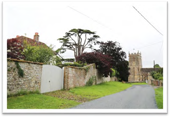
There are 23 listed buildings and structures within the parish, (see Table 2 below) one of which – the Parish Church of St Laurence – is Grade I listed, while the others are Grade II and II* listed.
Table 2: Listed Buildings in Holwell - Source Historic England
|
|
More detail on these buildings and structures is shown in Appendix P12.
In addition to these, there are other features that residents see as contributing to Holwell’s unique character, At Appendix P13 is a list of Locally Important Buildings and Structures and features of Holwell that should be considered in this light. Some examples are listed below
There is also a range of traditional buildings throughout the area which are associated with farming. These buildings can be divided into two sub-categories: farmhouses and cottages. The majority are constructed of rubble stone; however there are also some brick and rendered examples. All are two-storeys high and have features such as porches with pitched roofs, tiled roofs and timber windows. Most of them appear on the 1886 Ordnance Survey map and are good examples of the vernacular architecture of Holwell. They all contribute to the local distinctiveness of the area and are considered to be buildings of local interest
Our historic buildings are protected through Listing, and given strong protection under the relevant legislation, national and Local Plan policies. However there are some buildings in the village that date from the 19th and 20th century (or earlier) that are not currently Listed or on a Local List but which could be considered of local interest and contribute positively to the character and heritage of the area.
POLICY E3 : BUILDINGS AND STRUCTURES OF LOCAL IMPORTANCE
Direct or indirect harm to Identified Locally Important Buildings and Structures (as shown in Appendix P13) should be avoided unless clearly justified, having regard to the contribution the asset makes to the historic and architectural character of the area balanced against the scale of any harm or loss taking into account the potential to avoid harm through changes to the scheme design.
The parish is drained by numerous small streams and springs that generally flow northwards towards Caundle Brook, a slow-moving river which often causes water spillage into surrounding fields. There are a number of other water courses and tributaries throughout the village, all of which may break their banks under certain conditions.
Since the area is largely of Oxford Clay, in periods of prolonged or heavy rain, water can gather rapidly and even higher areas of the parish can flood - parts of Holwell Drove, Fosters Bridge, Packers Bridge below Packers Hill, Pulham Road, Stony Lane, Peaceful Lane and Crouch Lane are particularly susceptible. Flooding occurs because culverts and drains pass under roads and may not be able to absorb the full volume of water, or because ditches have been infilled and the piping beneath is inadequate. Blocked drains and ditches are a particular problem in Stony Lane, causing ice formation in cold weather. There have been isolated cases of heavy surface water flooding properties in the past, and farmland can also flood rendering it impossible to put cattle out.
The Working Group reviewed the Flood Maps available for the parish of Holwell (Appendix P11) to ensure they were aware of the main areas that should be noted throughout the site selection process. With the sites selected and put forward in this Plan, there do not appear to be any flood issues and the Working Group agreed that no specific policies are required.
Holwell is a dispersed settlement concentrated mainly along Crouch Lane, Fosters Hill and Pulham Road. The village comprises low-density development of predominantly detached houses set back from the road in large plots, characteristic of a rural area. The typical materials and architectural detailing used throughout Holwell contribute to its local vernacular and reinforce the distinctiveness of the area. Its rural character is reinforced by the extensive verges and gardens which surround most properties, allowing views across the area and beyond to the rural landscape. Away from the main settlements, agricultural buildings also contribute to the rural character of the area.
The design of new buildings should look to enhance local character. Design quality should focus on reinforcing local distinctiveness, but not preclude originality or achieving energy efficient designs. The following provides design guidance that picks up on the distinctive characteristics of this area. Examples are provided in the pages that follow.
Policy E4: Design
Any future development should be designed to reinforce the distinctive rural character of Holwell parish. This should include reference to and consideration of all of the key characteristics, as described in Table 3 below
Table 3: Design Policy Key Characteristics
| Aspect | Guidance | Examples |
|---|---|---|
| Density, scale and orientation | The scale of development should be appropriate to the size of the plot and general character of the surrounding area.
Spacing between buildings should allow for views through to the wider countryside. New buildings should respect the existing height and roofline of adjoining properties. Extensions should be subordinate to the original building in scale and character. Extensions that exceed the height of the original building or extend outward by more than 40% of the original building width are unlikely to be appropriate. |
- |
| Building line | The set back of new buildings (as measured from the back of the carriageway to the front elevation) should respect the existing building line along the street. | |
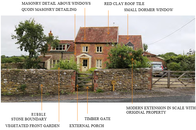
| Roof design | Careful attention should be paid to roofing materials, pitch, eaves and verge details and the inclusion of chimney stacks or other features that project above the ridge line. In general, a simple roof form is preferred. A typical palette in Holwell includes clay and slate roof tiles. | See Image 3 |
| Doors & Windows | Doors should be simple and well-proportioned; pastiche of historical designs should be avoided.
Porches are a common feature in Holwell and can be used to add interest. There should be a positive relationship between the building and the street, through placing the property entrance so that it is clearly visible from the road, and avoidance of largely blank walls with no doors or windows. |
See materials and design palettes |
| Materials | Materials used in new development should complement the materials typical of the existing buildings in the street, the streetscape or the existing building in the case of extensions. Whilst, exceptionally, an extension may intentionally be designed to be contrasting, such an approach will need to be carefully justified and its success will rely on a high quality design A typical palette in Holwell includes rubble stone and red stock bricks. Permeable surfacing materials should be used to provide adequate natural drainage. |
See materials palette. |
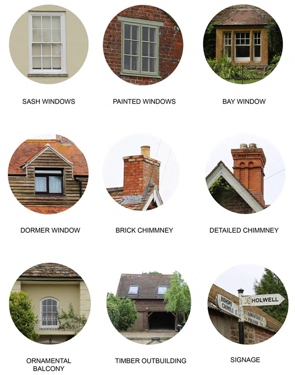
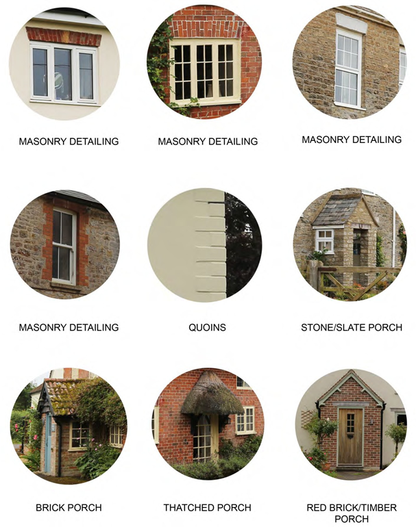
| Architectural quality and detailing | The design and amount and type of decoration and functional elements (such as the position and type of doors and windows, flues, chimneys, gutters and flashings) should complement the local vernacular but avoid overly detailed / pastiche elevations. Traditional elements often include detailing around windows including cills, quoins and masonry detailing, door surrounds or porches and timber framed, sash windows. Existing period detailing should be retained and the covering over or removal of such elements is not encouraged. The introduction of conspicuous domestic features and additional window or door openings in converted agricultural buildings should be avoided. Retention of existing features and a simple design approach is usually most appropriate. |
See design and details palettes. |
| Front gardens and boundary treatments | New development should reinforce the well-managed network of grass species rich verges, hedgerows and woodland lining the routes through the area, which are characteristic of the rural landscape. Existing front gardens should be retained. |
See Image 1 |
| Soft landscaping | In Holwell the rural landscape is the dominant feature; the buildings secondary. |
ILLUSTRATIVE EXAMPLES OF BUILDING/DESIGN STYLES IN HOLWELL
Image 1: Fosters Hill: the main residential street in Holwell
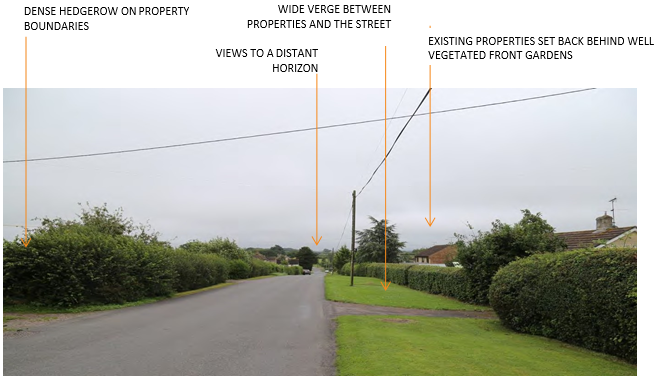
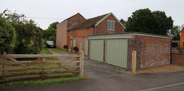
Image 2: Stony Lane
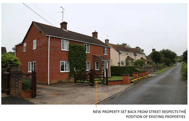
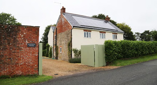
Image 3: Cottages, Gunville
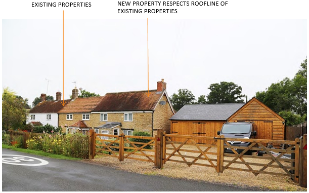
Image 4: Extended property, Pulham Road
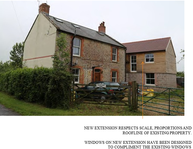
Image 5: Detached property, The Borough
Materials Palettes
Below are examples of building material that contribute to the local vernacular of Holwell and could be used to inform future development. It should be noted that these materials are not prescriptive and there is
opportunity for innovative and creative material suggestions in new buildings, restorations and extensions that may compliment what already exists.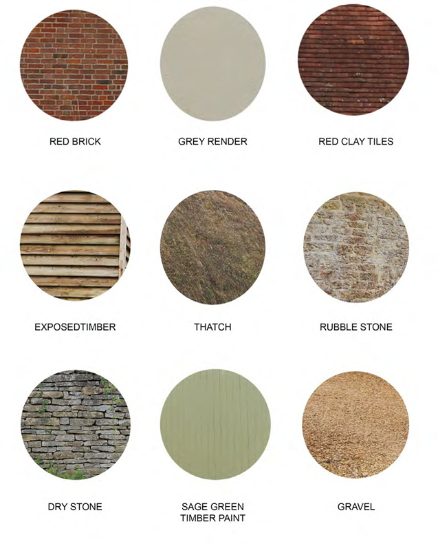
Details Palettes
Below are examples of architectural details that contribute to the local vernacular of Holwell and could be used to inform future development. It should be noted that these materials are not prescriptive and there is opportunity for innovative and creative architectural designs in new buildings, restorations and extensions that may compliment what already exists.
Windows/Chimneys/Additional Features
Masonry Detailing/Porches
Restoration precedents
Restored property, Foster’s Hill:
< Previous | ^ Top | Next >