
Map 6. Granby and Charlestown
6.1 Charlestown developed as part of suburban expansion of Weymouth during the 19th and 20th century, that took place initially as ribbon development along the B3157 Coast Road towards Abbotsbury from Westham Bridge. It now abuts the Granby Industrial Estate.
6.2 The post-war and modern housing estates and modern infill are a mixture of one and two storey buildings. They include small terraced and semi-detached houses, bungalows, and a range of modern detached, semi-detached and terraced houses. There are also three residential mobile home sites.
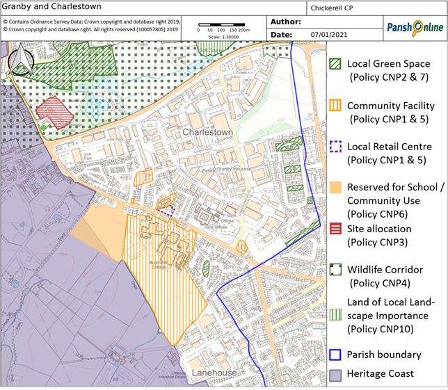
6.3 Within Charlestown there is Chickerell's secondary school (Budmouth Academy Weymouth, formally Budmouth College) , the Victory Hall, a Post Office and Stores and a church. The redevelopment of a petrol station site in 2018 has also provided a small retail area with a Co-op food store and two take-away restaurants. The nearby Post Office/Store serves both residents and businesses of the two industrial estates, and as such it is hoped that they will not be adversely impacted by the new Co-op store. This local centre had not been specifically identified through the Local Plan, and therefore has been defined in this Neighbourhood Plan.
Policy CNP 5. Charlestown Local Centre and other valued community facilities
Within the defined local retail centre in Charlestown (as shown on Map 6) retail and other E class or similar sui generis uses appropriate to a local centre will be supported. Any physical alterations should ensure that there is an active frontage that enlivens the streetscene, and make suitable provision for customer parking.
Development proposals to improve the provision of community facilities (including those listed below and shown on Map 6) will be supported, and every effort should be made to work with the local community and relevant authorities to investigate potential solutions to avoid any loss:
6.4 Chickerell's secondary school and sixth form (Budmouth Academy Weymouth), on the Heritage Coast side of the B3157, is the largest in the Chickerell/Weymouth conurbation. It operates its own day nursery from 4 rooms in a designated area of the college – this is primarily for college staff but is also open to children from around the local area. Also on site is Budmouth's Sports Centre, which is a dual-use sporting facility for the local community and Budmouth Academy Weymouth that opened in 2003. It is open seven days a week, but there are restrictions on weekday use during college term time which means that most classes and the availability of the outdoor facilities are outside the normal school hours.
6.5 The level of housing/population growth in the area is likely to necessitate an extension of Budmouth's education and sporting facilities (with sports facilities potentially being made available to the wider public rather than for exclusive school use). The land within the grounds of the Budmouth Academy Weymouth is safeguarded for school/community use under policy CNP 5 and policy CNP 6 seeks to safeguard the adjoining undeveloped land to the west (as shown on Map 6) for further education and sporting facilities, whilst recognising the area’s ecological and landscape value.
Policy CNP 6. Land at Budmouth Academy Weymouth
Land at Budmouth Academy Weymouth, as shown on Map 6 for school / community use expansion, is safeguarded for the academy’s future expansion and community sports provision.
6.6 Although not of a scale and majesty to rival the Fleet, there are a number of local green spaces within the built-up area which provide opportunities for informal recreation and greenery that are much valued by local residents.
6.7 Charlestown's Cobham Estate is sandwiched between Weymouth and Chickerell's Granby Industrial Estate. Historic maps indicate that the area was used and known as Chickerell Airfield or Flying Field, originally established towards the end of the Great War in 1918 and comprised of some 44.35 acres. It was subsequently developed following the Second World War as a planned estate in the 1960s by Weymouth & Portland Borough Council, although most of the roads have not been adopted by the Highways Authority, leading to some waste collection issues etc. Properties are now either privately owned or with a Housing Association, and there is little if any open space remaining for residential development. What little amenity space remains undeveloped should be preserved.
6.8 There is a further strip of amenity land that runs from Canterbury Close towards Chickerell Road. Whilst this land was originally intended as an access route to the adjacent industrial estate from Radipole Lane, it has been used for many years as informal recreation space by local residents, and has been recognised (at appeal) as having value in terms of the open suburban character of this residential neighbourhood and matches similar open spaces (such as in Cobham Drive).
6.9 The area of open space on Everdene Drive was similarly designed to enhance the character of this suburban housing area and allow some informal amenity use.
Policy CNP 7. Charlestown's Local Green Spaces
The following areas as shown on Map 6 are designated as Local Green Spaces, and, other than in very special circumstances, no inappropriate development will be permitted that would harm their reason for designation:
6.10 There are few, if any, opportunities for more residential development in Charlestown other than the replacement of existing dwellings within the defined development boundary. Although land on the south west side of the Coast Road at Charlestown has been suggested for development, it is not included in the 2018 Preferred Options consultation on the Local Plan, and development here would increase pressure on the Heritage Coast and its wildlife.
< Previous | ^ Top | Next >