
Map 3. Chickerell Village
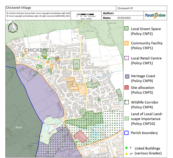
4.1 The main residential area of the Town is the ‘Village’ which has developed around the original West Chickerell and Putton settlements. The heart of old Chickerell is focused on North Square and East Street and this is reflected in the Chickerell Conservation Area (CCA) which was enlarged in November 2008 following a Conservation Area Appraisal to include the remaining areas of mainly c19 origin (including along West Street; the length of East Street to School Hill; and south into Putton Lane).
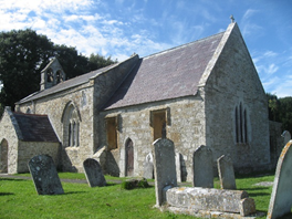
4.2 Within the Town there are 8 listed buildings/structures, 6 of which are in the CCA. There are also 22 unlisted buildings of character and group value identified in the Conservation Area Appraisal. The listed buildings include St Marys Church Grade (Grade 2*), Stonebank (Grade 2) and Montevideo House (Grade 2).
Map 4. Local retail centre (Chickerell)
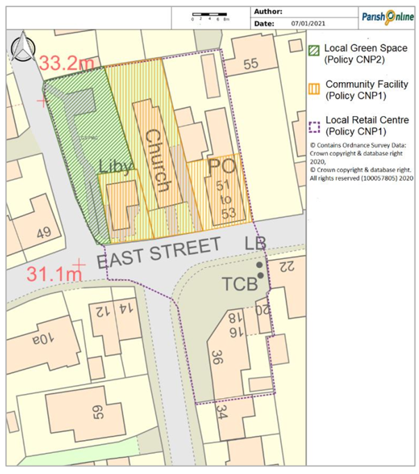
4.3 In the historic core there are four places of worship (churches), a Post Office stores, two pubs, a hairdresser, chemist and small Doctor's surgery. The area around the Post Office Stores in East Street functions as a small local retail centre that is important to the area’s identity and the clustering of uses contributes to the viability of the individual facilities. The Post Office is particularly well-used by local residents (according to the household questionnaire), and although the library is less well-used, about 50% of local residents within Chickerell Village responding to the household questionnaire said they used it. The Local Plan Review has suggested that this be identified as an important Local Centre, and such a designation can be made through this Neighbourhood Plan.
4.4 Willowbed Hall including Chickerell Town Council Offices is located on Putton Lane, and nearby is the Chickerell Primary School and the proposed site for the second such school. A site for the Town's Health Centre has also been identified.
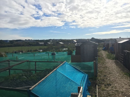
4.5 The 2006 and 2015 Local Plans allocated significant sites in and adjoining the Chickerell Village which, when developed, will add a further 1,100 homes to the area. It was recognised that these developments would require the provision of, inter alia, a doctors' surgery, allotments, multi-purpose community building, multi-use games area (MUGA), a new road connecting the Chickerell Link Road with School Hill, public open space and land for a second Chickerell Primary School, skate park, senior football pitch with a changing pavilion. Some of these facilities, such as the MUGA and play area and the allotments, have already been provided.
4.6 There are few if any opportunities to provide much needed infrastructure in central locations. The site originally allocated for Chickerell's Health Centre in now considered to be too small to meet NHS's Clinical Commissioning Group (CCG) requirements, who has proposed the need for a multi-use Health Centre in Chickerell. Chickerell Town Council has offered a couple of sites near Willowbed Hall for a new Health Centre. Monies from housing development are and will be available to at least part-fund this facility. The NHS Clinical Commissioning Group are progressing a scheme to bring this forward. If and when a new health centre is built, replacing the Doctor's surgery in East Street, it is expected that these premises should be converted to retail or other E class or similar uses appropriate for a local centre, and retain the associated parking.
Policy CNP 1. Chickerell Local Centre and other valued community facilities
Within the defined local retail centre in East Street (as identified on Map 4), retail and other E class or similar sui generis uses appropriate to a local centre will be supported. Any physical alterations should ensure that there is an active frontage that enlivens the streetscene, and make suitable provision for customer parking.
Development proposals to improve the provision of community facilities (including those listed below and shown on Map 3) will be supported. Every effort should be made to work with the local community and relevant authorities to investigate potential solutions to avoid the loss of any of the following facilities:
4.7 An environmental appraisal carried out by the former West Dorset District Council in 1999 identified that there was limited public open space within the ‘Village’ and its surrounding area. The plan proposed further planting within the built up areas (where opportunities arose) and extending public open space provision by protecting and acquiring further sites such as the playing fields, land at The Lugger Inn and land at Meadow Close and Montevideo House together with the areas identified as Land of Local Landscape Importance.
4.8 This Neighbourhood Plan can designate local green spaces for protection. These need to be demonstrably special to the local community for reasons such as their landscape or recreational value, well related to the settlement and not extensive in size. The following spaces would appear to meet these key criteria:
4.9 Smaller spaces, such as the grassed areas off May Terrace, Marshallsay Road and Fisherman’s Close, whilst perhaps not worthy of local green space designation in their own right, play an important role in collectively contributing to the village’s character (particularly in light of the suburban character of much of the 20th century estate development).
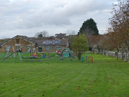
4.10 The Willowbed Hall field (which contains a children's play area and multi-use games area (MUGA)) and Chickerell Primary Schools Sports Field (which is used for sports and recreation and provides an area of green space within the heart of the village) are also important green spaces, but have been included under Policy CNP1 so that there is some flexibility for further facilities to be developed in these locations if required (particularly given the school’s intention to remain in situ).
4.11 The Crook Hill Local Nature Reserve is an important wildlife area but is already designated as a Local Nature Reserve and is part of the Crookhill Brick Pit Site of Special Scientific Interest and Special Area of Conservation. It therefore does not need the additional protection of Local Green Space designation.
4.12 The Water Lily Farm between the Woodland Trust site and Putton Lane is also valued as a visitor attraction with its beautiful gardens and ponds. The gardens are a 'Site of Nature Conservation Interest' and home to abundant wildlife. The gardens are accessible by admission (usually open from April to September) and also functions as a Wedding
Venue. As there is no right of access and limited
public views into the site, it does not readily meet the Local Green Space criteria. However it is included within the wildlife corridor identified under, as detailed in section 4 (Policy CNP 4).
4.13 Having reviewed the amount of public open spaces against the Fields in Trust standards, it is clear that there is still a significant shortfall in available and accessible public open space of all types. There are a number of green spaces planned as part of the strategic allocations to the north and west of the village, which will increase the level of provision but may not fully address the shortfall. Some of these spaces, when delivered, may be considered for Local Green Space designation in a future review of this plan.
4.14 The larger areas around the village designated in the adopted Local Plan as Land of Local Landscape Importance are too extensive to be designated as Local Green Spaces. However, part of these areas continue to be given special protection as locally valued landscapes and important wildlife corridors, see later in this section (Policy CNP 4) and section 11 (Policy CNP 10).
4.15 There are relatively few trees, especially mature trees, remaining within the village and it is imperative they are protected and replacements planted when possible. Some, but not all, are protected by virtue of being within the Conservation Area or covered by Tree Preservation Orders.
4.16 Retaining and potentially increasing the number of trees in the village, within public areas and on the few remaining large gardens will have multiple benefits in terms of retaining the village character, providing wildlife habitats, and opportunities for shade. In response to the 2017 survey, there was very strong support for retaining the few remaining hedgerows and preserving as much of the rural nature of the village as possible. It is recognised there will be some windfall sites that may be proposed for development but these will need to be considered with due regard to the need to protect trees and the few remaining large gardensPolicy CNP 2. Chickerell Village Local Green Spaces
The following areas (as shown on Map 3) are designated as Local Green Spaces, and, other than in very special circumstances, no inappropriate development will be permitted that would harm their reason for designation:
Development within and adjoining Chickerell Village should respect and enhance local landscape character, including the retention of mature trees and native hedgerows, and the smaller green spaces that collectively contribute to the village character. Infill development of garden land will be resisted where there is a lack of tree cover in the surrounding area.
4.17 Along the B3157 Coast Road travelling North West from Chickerell Village through Knights in the Bottom, the landscape is particularly sensitive with the area South of the road Heritage Coast and part of the Dorset AONB. There would be a significant impact on the landscape if this area was to be developed, and important views over this area from both Chickerell Village and the Coast Road. Our consultation did not evoke any support for development in these areas, and major development in this location is not supported by the Local Plan.
4.18 As explained in the introduction, there is significant growth planned for the Parish as allocated through the Local Plan, which means that this Neighbourhood Plan does not need to allocate further housing sites to meet local needs.
4.19 The defined development boundary of the ‘Village’ includes the Local Plan allocations and is bordered by the B3157 Coast Road and Heritage Coast to the South-West, a green wildlife corridor and the Chickerell Link Road to the South- East, and open rolling countryside to the North. Although this Neighbourhood Plan does not seek to change the existing defined development boundary of the village, given the above, this Plan has identified one further opportunity where residential development may improve the character of the local area and as such justify a further allocation. This is the caravan site at the rear of the listed Montevideo House, which is outside the current defined development boundary. The site allocation is limited to the area on which caravans can lawfully be sited (including the area permitted under planning application WD/D/19/001358).
4.20 Montevideo House is described (in its Listing) as an early 19th century 3-storey, L-plan detached house with stone walls, stuccoed and painted and slate roofs with low brick chimney stacks on the end gables. The listing includes more information on its details such as the doors, windows and decorative features. There are a number of curtilage outbuildings to the north of the main house, and the original building is rather overpowered by its own extension. However, the main façade of the building is at right angles to Chickerell Road and faces its own gardens, with the affect that its original character can be read (from the gardens) in isolation from the later additions. The residential park homes, although not clearly visible from the house, together with the park homes advertisement hoarding, could be considered to be detrimental to its setting and affect its aesthetic value. Because of this, the Conservation Team at the Local Planning Authority have indicated that a low density housing that reflects the historic character of the subservient curtilage buildings could be accommodated on the park home site, in place of the park homes.
4.21 Wessex Water have advised that there is an existing public sewer and pumping station on the site serving the upstream catchment. As such, early consultation with Wessex Water is essential to ensure any drainage strategy and protection / proximity measures are properly considered and assessed.
4.22 The change from residential park home to housing is unlikely to increase the number of occupants, and it is not expected that this development would increase recreational pressures on the Chesil and the Fleet designated site. However the impact of the potential increase in recreational pressures, arising from the development, on the nearby Chesil and Fleet designated sites will need to be assessed as part of any application and, where appropriate, measures taken to avoid adversely affecting what is an internationally important wildlife site (in accordance with Policy ENV2 of the Local Plan). Similarly, any development taking place in this area must demonstrate that there are no direct or indirect negative impacts on the Great Crested Newt population (which whilst mainly associated with the Crook Hill brickworks SAC, has a much wider breeding, foraging and hibernating area).
Policy CNP 3. Land to the rear of Montevideo House
Land to the rear of Montevideo House (as shown on Map 3) is allocated for housing, provided that the use and design would sustain and enhance the significance of the Listed Building and make a positive contribution to its setting, local character and distinctiveness. The layout and design will need to avoid damage to the existing public sewer and pumping station on the site, and the plans should clearly show how the disposal of both foul and surface water run-off will be dealt adequately. Any proposal must demonstrate that there are no direct or indirect negative impacts on the internationally designated wildlife sites and associated protected species that cannot be appropriately mitigated, in accordance with Policy ENV2 of the Local Plan..
4.23 To the South and South East of the Village there is a green lung which is an important wildlife corridor and open space between the Chickerell Link Road and Weymouth Football Stadium. Over 99% of responses to the household questionnaire believed that this should continue to be protected from development.
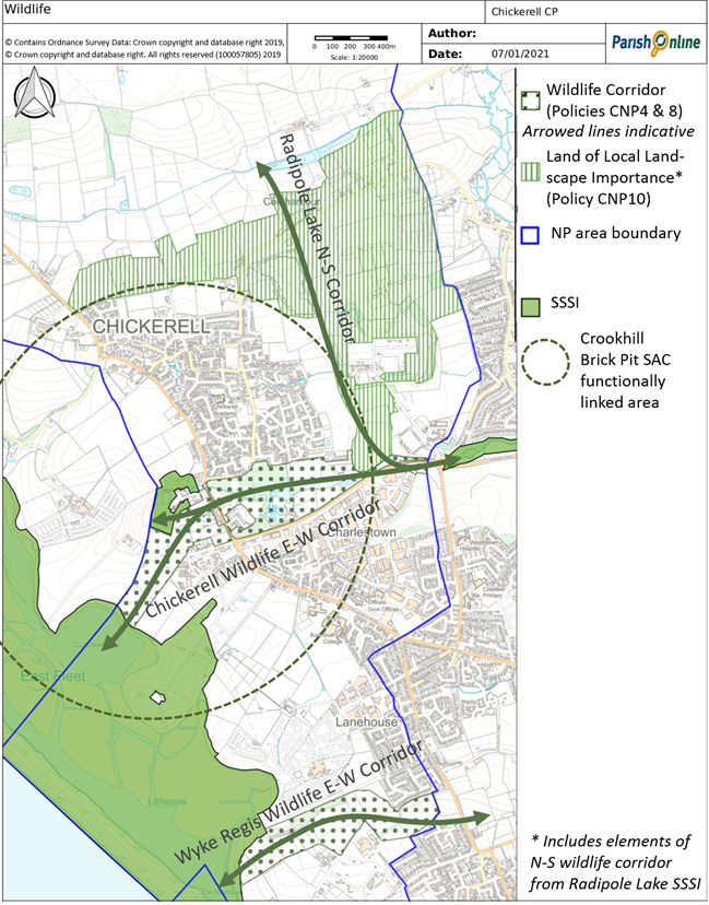
4.24 This wildlife corridor is followed by migrating birds spreading out from landfall at Portland Bill to the rest of the UK. The Woodland Trust and Water Lily Gardens SNCI form part of the wildlife corridor running east–west (connecting the internationally important Fleet RAMSAR site to Chaffey's Lake and onwards to the RSPB Radipole and Lodmoor wetland reserves), as well as north-south (linking Radipole Lake SSSI with the wider countryside). These routes are also likely to be used by otter and possibly water vole, both important species that are now resident on Radipole Lake SSSI. The Water Lily Gardens are also home to rare dragonfly species, water voles and bats, which forage in the general area. The 9 hole Golf Course, and in particular the hedgerows around its borders, contributes to the wildlife value of this area, and its open, undeveloped nature is an essential part of the green gap, and it is therefore protected as part of the locally valued landscape north and east of Chickerell (see section 10 Policy CNP10).
4.25 The small Crook Hill Nature Reserve (a European designated SAC) is also on this route, and included a population of Great Crested Newts (one of the largest populations in this country, and a European Protected Species). Great Crested Newts generally stay within about 250m of their breeding pond, but they spend a significant amount of their time out of water (the terrestrial phase of their annual lifecycle) and some disperse to colonise sites up to 1km distance. Natural England have advised that a wide area (up to 1km from the SAC and surrounding breeding ponds) is therefore potentially ecologically important to the lifecycle of this protected species, and breeding, foraging and hibernating habitats and connecting corridors within this ‘functionally linked land’ should be maintained, to ensure that the Great Crested Newt colony is not adversely affected by development.
4.26 The Local Plan’s allocation east of Chickerell includes the requirement for the development to connect to the Chickerell Link Road, which will inevitably impact on this wildlife corridor. Great care will be needed in the design of this route in order to ensure that its impact on wildlife is minimised. The wildlife corridor should not be seen as an insurmountable impediment to providing a new road connecting the Chickerell Link Road with School Hill (LP policy CHIC2) and indeed the Town Council considers this link to be much needed.
Policy CNP 4. Chickerell Wildlife Corridor
The undeveloped Chickerell Wildlife E-W Corridor (as shown on Map 5) forms an important network of multifunctional green space capable of delivering a wide range of environmental benefits. Development that would significantly detract from this function will be resisted. The impact of any development required for the delivery of the new road connecting the Chickerell Link Road with School Hill (LP policy CHIC2) should not result in any significant adverse consequences which cannot be successfully mitigated.
Map 5. Map of Wildlife Corridors and sites
< Previous | ^ Top | Next >