
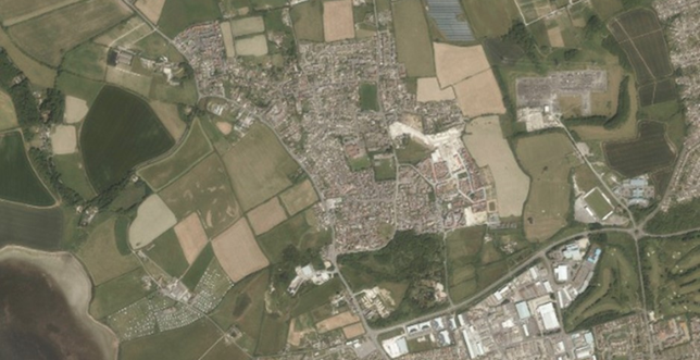
2.1 The Town (Parish) covers an area of 15 sq km extending inland for about 7km. Part of the Town lies within the Dorset Area of Outstanding Natural Beauty (AONB) and the West Dorset Heritage Coast. The underlying geology and resultant topography have given the surrounding landscape its distinct character.
2.2 The B3157 (Coast Road) connects Chickerell's two main urban areas and is the main links to surrounding areas. The Neighbourhood Plan area includes:
2.3 Although there is a clear relationship between Chickerell and Weymouth due to their proximity, Chickerell also has a long-standing relationship with West Dorset and the Chesil Bank parishes to the West. Many Chesil residents attend, for example, Chickerell schools or use Chickerell facilities. Chickerell and Fleet are now a united Church of England benefice, and share a community magazine ("Contact"). Some parts of Chickerell share facilities with Weymouth (for example one of the two Doctors' surgeries serving Chickerell is located just over the border in Weymouth), and some facilities that cover Weymouth, such as the 'West Weymouth' Police Station, are within Chickerell. However, for Chickerell residents without transport, shopping at many of the supermarkets located in Weymouth is difficult.
2.4 The rural areas have a predominantly arable landscape of large fields, and are characterised by a series of ridges on an approximate east/west axis which broaden and flatten nearer to the coast. A sense of rural remoteness in the northern and coastal parts contrasts with the more urban character in the East adjoining the larger town of Weymouth, partly due to the extensive removal of hedgerows in the past not only by landowners but for Highway improvements. There are some dry stone walls remaining in places. These dry stone walls together with the remaining hedgerows are important features of the landscape and are also important wildlife habitats and corridors. Woodland is sparse, being limited to a few small copses on the western edge of the parish, but nonetheless are important in both landscape and wildlife terms.
2.5 Only small parts of the Neighbourhood Plan area lie within the Dorset Area of Outstanding Natural Beauty (AONB). The AONB runs along the parish boundary from Chesil Bank and into the parish as it follows the Coast Road heading North-West of the village. To the north of the parish, the fields north of Pucksey Brook heading up to the ridge and the Jubilee Trail (which runs east from Friar Waddon Hill) are also within the AONB. However the countryside is generally picturesque and due to the views in and out of the AONB, much of the undeveloped western part of plan area would be considered to form part of its setting.
2.6 The Chesil and the Fleet SAC, SPA and RAMSAR site covers much of the coastal area to the south and west of Chickerell. This area is of international importance for wildlife, and there are also important wildlife corridors linking from this to Radipole Lake SSSI (Site of Special Scientific Interest) to the east. Natural England has identified another corridor from The Fleet across Mandeville Road (Wyke Regis). Opportunities should be taken wherever development is proposed to ensure wildlife corridors are enhanced and included as an integral part of that site’s layout.
2.7 Crookhill Brick Pits supports a large population of Great Crested Newts (including one pond which has been recorded to have one of the highest counts of the species in both Dorset and Europe) which is why the site is a SAC for the species. However, these species are known to range much further afield and are not therefore limited to this site. Local records include sightings of badgers, bats, water voles and otters as well as many different bird and reptile species.
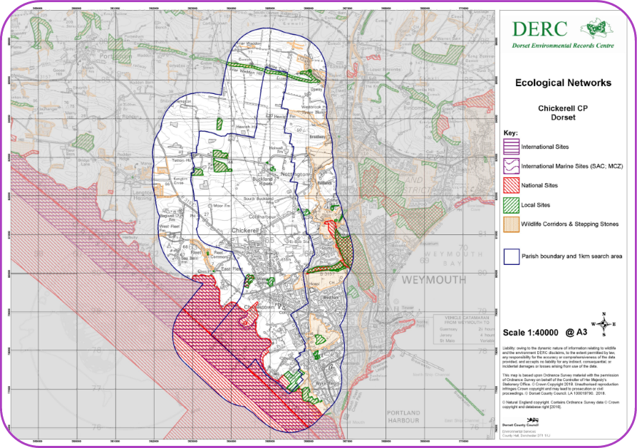
2.8 Map 2 (produced by the Dorset Local Nature Partnership and Dorset Environmental Record Centre), shows the protected sites within the parish. Further information on protected sites within and around the parish can be found at the following links:
2.9 Ecological networks are a mixture of wildlife corridors (including hedgerows) and stepping stones, by which our flora and fauna are able to move across and through the landscape. Some of these are important wildlife sites, but other areas exist in their own right, providing an additional, important level of protection for wildlife. Some wildlife, such as birds, bats and some other mammals, can move through the landscape quickly. Other species, in particular many species of invertebrates and plants, require years, decades or even longer to move often relatively short distances, so the long term existence, stability and enhancement of ecological networks is vital to both maintain and enhance the biodiversity of the parish. More information on ecological networks in Dorset can be found at the following link:
Map2: Ecological Networks (to be read in conjunction with wildlife corridors on Maps 5 and 7)
2.10 Chickerell, unlike its near neighbour Weymouth to the East, is mentioned in the Doomsday Book (as Cicherelle) and was a bronze age settlement. Recent archaeological finds date back to the 1st Century. The Church of St Mary the Virgin dates from c. 1260 replacing a wooden church dating from c.700. [Source: Chickerell "Yer Tiz" an Illustrated Compilation of Historical and Social Information published by Chickerell Parish Council.]
2.11 In the 1800s local employment was probably dependant on farming and fishing but residents' occupations are now varied. Defence establishments and related industry would have provided significant employment until the 1990s. The Town of Chickerell is not as reliant on Tourism as is Weymouth.
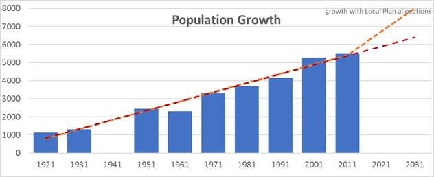
2.12 The population of Chickerell has grown considerably over the last few decades achieving Town status in 2001. In 2017 it was estimated to have a population of about 5,840 residents. Its growth rate is likely to rise further with the number of homes currently planned through the adopted Local Plan’s allocations.
2.13 The Neighbourhood Plan consultation (2017) established a number of key issues which were agreed by a clear majority of respondents. Firstly, that Chickerell, particularly the ‘Village’ and Charlestown, should retain a separate identity from Weymouth, although it is inevitable that there will be a close relationship between the two towns.
2.14 The Heritage Coast, The Fleet, and the countryside to the North and West, part of which is within the Dorset AONB, are highly valued and should be preserved for future generations. Local residents also consider that the wildlife corridor alongside Chickerell Links road connecting the Fleet via the Crook Hill Nature Reserve and through to the wider countryside should be protected as much as possible, and that further building on the Heritage Coast side of the B3157 Coast Road should be discouraged. Respondents in particular valued the Woodland Trust land, Willowbed Hall Field, and the fields surrounding the Chickerell Village and down to the Fleet. There were also many comments about protecting the remaining open spaces within the village – typical comments included:
2.15 The high quality landscape of our part of Dorset makes settlements like Chickerell an attractive place to live and retire to. The population profile of Chickerell has a much higher number of older residents when compared to England average (according to the 2011 Census 24.5% of the population were aged 65 or older, compared to 20.9% in Weymouth and Portland and just 16.3% in England, and 2017 estimates now put the number of people over 65 year at 25.7%). Our ageing population places demands on health, housing and support services.
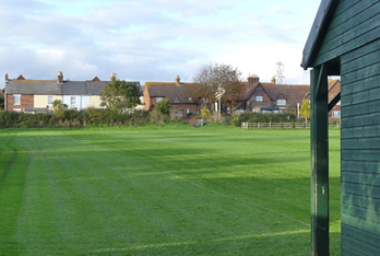
2.16 Chickerell does not currently have some of the facilities that you would expect of a population of its size, including, for example, a full size community sports field and tennis courts (other than very limited community access to those at the Budmouth Academy Weymouth’s sports complex). In response to the Neighbourhood Plan consultation (2017) issues raised included the need for improved / additional public transport, calls for the youth centre to be re-opened, support for a community sports complex, more allotments, and an outdoor gym. Having a plan-led system provides the best opportunity for delivering some of these facilities, although this will also depend on other factors such as the viability of the development and the availability of suitable land. Whilst more frequent and improved bus services would be welcomed, this is not something that can be readily achievable through a Neighbourhood Plan. Dorset Council’s own plan (for the period 2020-24) states that they will improve public transport and reliability by working with providers and lobbying Government. Chickerell Town Council would be happy to work with Dorset Council to identify the routes and services which local residents most want to see improved. Also, the planned development to the east of the village is intended to include a spine road designed for bus transport which could provide the opportunity for more effective bus routes.
2.17 There was a clear view that employment should be supported and land for employment protected, and that more infrastructure is needed. There was general acceptance that Chickerell is an appropriate place for development, and some growth is inevitable, but that further new housing allocations should be delayed until current extant allocations are nearing completion. There were concerns expressed that too much new building (particularly infill) could damage the area’s character.
< Previous | ^ Top | Next >