
9.1 One of the main aims of the Neighbourhood Plan is to protect and enhance existing pedestrian routes and provide new footpaths and cycle routes from new housing or business developments to encourage people to walk and use the local community facilities easily and safely.
9.2 Also, with an aim of avoiding increase in traffic congestion in the village centre and providing good access to the beach and foreshore, we have also set an objective to protect the existing car parks and large parking areas from new housing developments.
9.3 Within this section, we have also considered and addressed issues of mobility, transport and safe movement within the village, supporting our aim and objective of enhancing the quality of social life within the village.
9.4 Charmouth is surrounded by attractive walks and has many public footpaths including the South West Coast Path.
At 630 miles the South West Coast Path is Britain’s longest path stretching from Minehead to Poole Harbour. The village is on the South West Coast Path and what will become the England Coast Path (to be completed in 2021) and is also on the Monarch’s Way long-distance footpath, with its historical links to King Charles II and Charmouth’s own story of when he stayed here.
9.5 The coast path immediately to the east and west of Charmouth was diverted for many years due to landslides, but work has been progressing on replacement stretches. The England Coast Path is being created by dedicated Coastal Access teams within Natural England working with local authorities and landowners.
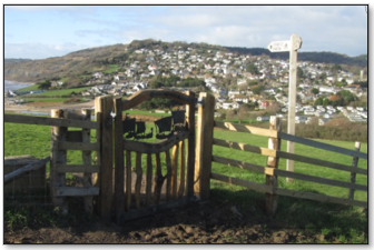
Coast Path- New Parish Gate on Stonebarrow, looking west to the village
9.6 The new footpath routes are almost complete. After crossing the footbridge over the River Char, the eastwards footpath up Stonebarrow was reinstated in autumn 2020, complete with new signage. Work on the westwards replacement section of the footpath from the top of Old Lyme Hill in Charmouth to Lyme Regis, will be completed in 2021.
9.7 Pathways are an important feature within Charmouth. To make it easy to walk around the parish and into the surrounding countryside connecting footpaths are important to maintain and improve, so residents and visitors can enjoy the beauty of the surrounding countryside and coastline which makes Charmouth a vibrant and attractive place in which to live.
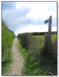
Footpath off Higher Sea Lane
9.8 From the Village Survey, 90% of respondents in the village use the local footpaths. There were 52 comments about the reinstatement of the South West Coast Path (i.e. for SWCP to be off-road) indicating its importance to local and visiting walkers. There was also good support for reinstating the footpath along the east side of the river, from the beach to Stonebarrow Lane, which is no longer in use. A small stretch of this footpath, at Stonebarrow Lane end, is located outside the NP area within the parish of Stanton St Gabriel and remains in relatively good condition.
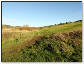
Part of the footpath along the east side of the River Char which is no longer fully in use
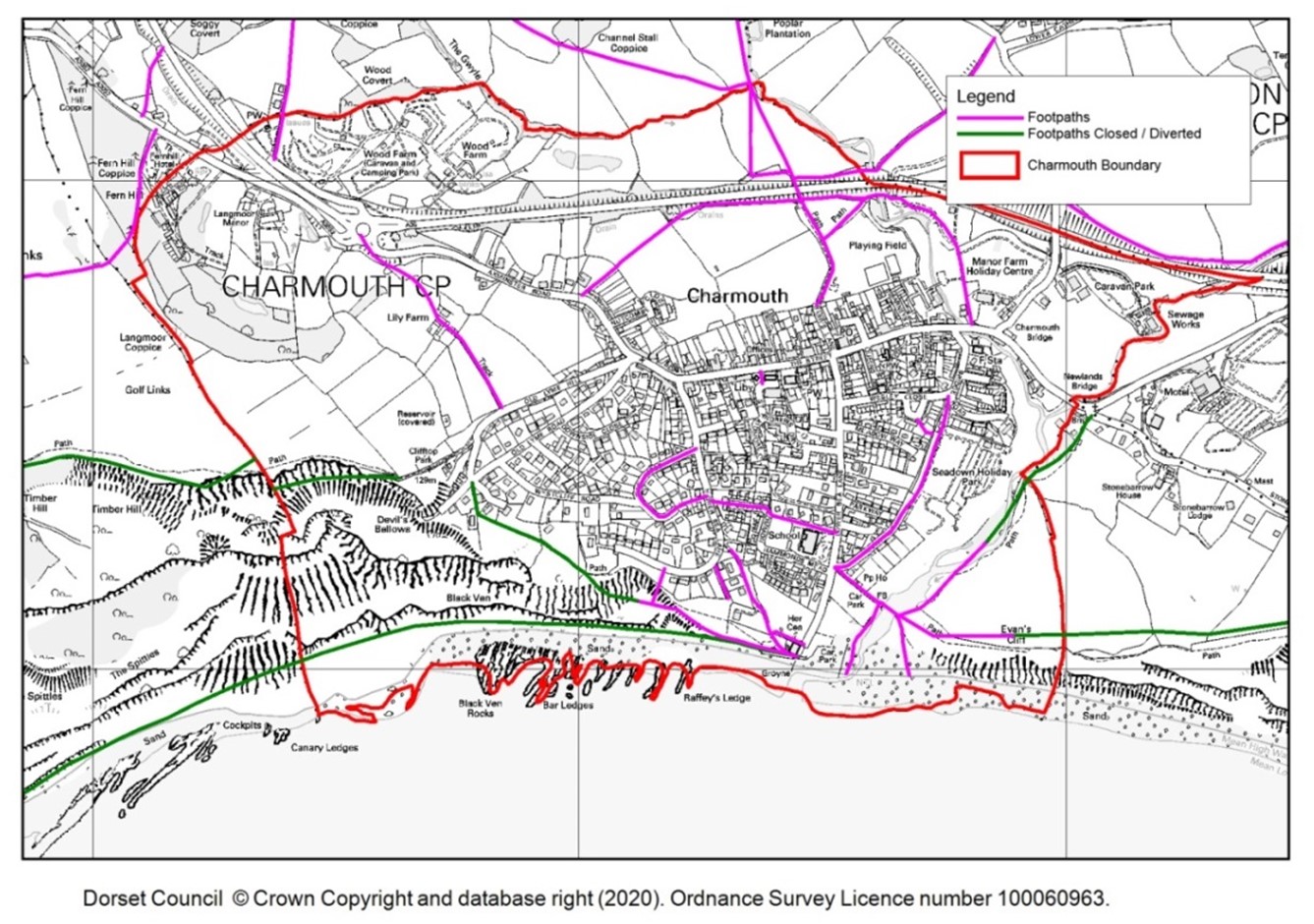
See Map 9.1 showing the existing footpaths, including footpaths that are closed. It should be noted that there are footpaths shown on the OS map and the official Dorset Council footpath map, which are no longer on the ground and have been closed or diverted.
9.9 There is considerable concern about the future of the local footpaths, not just about the reinstatement of the SWCP, but also that unrecorded footpaths and bridleways created before 1949 which cannot be recorded after 1 January 2026 (‘Countryside and Rights of Way Act 2000’).
9.10 Existing pedestrian routes should allow safe and attractive walking, and, where possible, be useable for people with mobility difficulties. In particular, routes into the village centre to shops, the community and leisure facilities, the school and the seafront are paramount.
9.11 Walking rather than using a vehicle is to be encouraged for health, wellbeing and reducing vehicle congestion in the village, as well as making a contribution to preserving the environment. This is in line with the Strategic approach stated in the Local Plan which states ''Community facilities that help promote social interaction as well as minimise the need to travel by car should be provided within local communities.''
9.12 There are a number of areas where pedestrian routes could be improved, by either making the existing route more pedestrian-friendly, or creating new off-street foot and possibly cycle paths to enable better, safer connections. Specific areas are suggested in the VS Report Q5.
9.13 Therefore, maintaining and protecting the current network of pedestrian routes is vitally important to the village's day to day life and visitors to Charmouth.
9.14 Policy GA1 has therefore been included to ensure the protection and enhancement of existing routes and the requirement of new routes to connect with them.
9.15 For new housing development, this Plan requires new access routes to link with existing pathways to encourage walking and enable those with mobility issues to safely use pavements and dropped kerbs. Clearly we want any new housing development (e.g. rural exception sites) to have good access and be in easy walking distance of local facilities and amenities in the village.
9.16 It is important that in designing the layout of development within or adjoining the village, due consideration is given to how the site connects to the existing pedestrian and cycle route network. In line with the ‘Town and Country Planning Order 2013’, a Design and Access Statement is required from Applicants to explain and demonstrate that proposed developments can be adequately accessed by prospective users.
9.17 Developments that are likely to generate increased traffic movements should be accompanied by a transport assessment, and this should include consideration of the potential likely impact of increased traffic on the safety of this network, and how any adverse impacts can be mitigated.
9.18 As a result of the Habitats Regulations Assessment, see Appendix E, it was identified that pedestrian routes that are to be enhanced including those footpaths within Sidmouth to West Bay SAC are likely to contribute to human intrusions and disturbances within the European site. See 6.15. The mitigation for this effect is contained in Policy HRA1: Habitats Regulations and should be read in conjunction with policy GA1 below.
9.19 The Policy LP-COM7 – ‘Creating a Safe and Efficient Transport Network’, supports the following policies on pathways, roads, traffic and parking.
9.20 Therefore, the policies, within GA1, have been included for the requirement of new footpaths and cycle connections (and their design) that connect new housing developments with existing networks.
POLICY GA1: Pedestrian Routes Existing Pedestrian Routes
New Pedestrian Routes
|
MAP 9.1 Existing and Closed Footpaths
9.21 From the Village Survey (VS), the numerical analysis showed that 59% of us walk within the village every day and 37% drive every day and over a weekly period 51% of us drive, 22% use the bus and 22% walk. We occasionally use bicycles and taxis.
9.22 From the 2011 census for Charmouth parish, 82% of households have at least one car/van with over 30% of households having 2 vehicles or more. A higher percentage of households (18.1%), within Charmouth, do not have a vehicle compared to West Dorset (15.7%).
9.23 Traffic levels significantly increase in the summer months, due to visitors to the village, causing traffic congestion; this is aggravated by ‘poor’ parking within the village. This was identified within Q21 Report (VS) – Transport: Parking.
9.24 Comments from the VS indicate that Charmouth needs more parking. That said, 45% felt the main roads had adequate parking arrangements whilst 40% thought not. There were however a significant number of comments, in excess of 170 regarding car parking, reflecting the general view that more parking was needed particularly in the summer period. Residents also considered there wasn't enough enforcement of parking restrictions.
9.25 Certain areas on the roads in the village were identified in the VS as being dangerous and suggestions of restructuring of parking were given. Many of the comments received (25 in all) on this particular parking theme related to parking on The Street.
9.26 A lack of parking, particularly on The Street, is clearly a frustration from the VS for residents and doesn’t help in encouraging visitors to use local shops, facilities, etc., which is contrary to one of our main vision aims and objectives for this Plan.
9.27 It should be noted that many residents have to park on the road as many of the older properties do not have any parking space.
9.28 The lack of dedicated parking spaces, including garages and increased levels of car ownership, has created parking problems where levels and location of on-street parking, particularly on The Street has made it difficult for road users to pass parked cars; this has caused aggravation and road safety concerns to residents, pedestrians and cyclists.
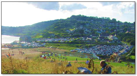
9.29 In general, the shops do not have parking for either employees or deliveries so again, all parking, short and long term, is on the road. This can be seen in photographs of the village where roads have vehicles parked on either or even both sides. See Photographs on page 20, 44, 47, 48 and 49. This issue is also reflected in the VS results where a lack of parking, difficulty in parking leading to inconsiderate or even dangerous parking, was noted, particularly during the busy holiday periods. During these periods the main car parks often become full. See photograph below.
Busy summer's day showing all coast car parks full
9.30 LP-COM9, Section 5 sets out Parking standards for residential and non-residential development. The guidance for non-residential (e.g. retail outlets) parking shows that the amount of ‘on street’ parking spaces is clearly below what is required for new developments. This is no surprise as most of these shops have been retail outlets for many years some dating back before cars were around and, in any case, car usage has significantly increased in recent years.
9.31 Although there is a public car park (St Andrew's Drive) only 300m from the village shops there appears a reluctance to use it for short-time activities. Measures to further encourage its use is worthy of consideration as part of VIP (Village Improvement Projects). See Appendix G.
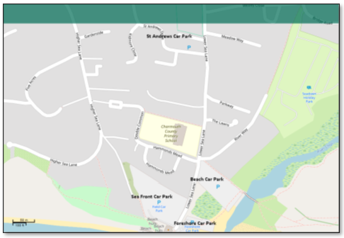
9.32 Available car/coach parking spaces are shown in Table 9.1. Car parks are largely used by visitors/tourists and often full during holiday periods.
The majority of public car parking in Charmouth is based by the sea and next to the river and so will be affected by climate change/sea level rise/stormy weather/storm surges. See Chapter 6: Natural Environment and Chapter 10: Energy Efficiency and Coastal Change.
TABLE 9.1 Available car/coach parking spaces in car parks
Car Park |
Ownership |
Car spaces |
Coach Spaces |
Notes 1 |
Notes 2 |
St.Andrew’s CP |
Dorset Council |
27 |
3 |
+m/c spaces |
|
Beach CP |
private |
~200 |
not allowed |
No marked spaces |
aka gravel or footbridge CP |
Seafront CP |
private |
~200+ |
not allowed |
Closed in winter |
aka Field CP |
Foreshore CP |
CPC |
52 |
not allowed |
+m/c spaces |
|
Foreshore CP overflow |
CPC |
~12-15 |
not allowed |
No marked spaces |
|
TOTAL |
|
500+ |
3 |
|
|
9.33 All car parks, except St Andrew’s, are situated in an Area of Instability Zone 3 as shown on Map 6.7 in Section 6.80-6.85. From the Shoreline Management Plan (SMP2), it is forecasted that 50% of the public car parking will be lost if the sea defences fail.
9.34 As a result of the Habitats Regulations Assessment, see Appendix E, it was identified that building on the car parks although permitted in exceptional circumstances, is adjacent to the Sidmouth to West Bay SAC and has the potential to affect the European site due to its proximity. The mitigation for this affect is contained in Policy HRA1: Habitats Regulations and should be read in conjunction with policy GA2 below. See 6.15.
9.35 The village is constricted in its capacity to provide additional parking so existing parking facilities need to be protected.
9.36 The use of existing car parks and parking areas for new buildings (other than a building that has to be near the shore) or for the building of new housing developments will not be supported. Therefore, to support this aim the policy GA2 has been included.
MAP 9.2 Car Parks in Charmouth
9.37 Any new housing developments pose the risk of making the traffic/parking situation worse so planning any such developments needs to address the potential impact. Due to the shortage of parking, housing development that results in a loss of parking on roads (e.g. drop kerbs) or within residential or non-residential premises will not be supported unless it can be demonstrated there is excess parking being provided or there is no net loss.
9.38 An increase in traffic is acceptable to facilitate new housing and businesses, provided traffic management is planned to maintain safety, avoid congestion by providing adequate parking and protecting those local landscape features that characterise Charmouth village.
9.39 So, in supporting new housing developments, and the likely impact from increased traffic, street parking needs to be avoided and the safety impact upon existing routes and users of pedestrian/cycle routes must be duly considered.
9.40 Due to the specific problems of parking within Charmouth, as mentioned above, all new homes will be required to provide off-street parking with a minimum of 2 spaces for each house unit with 2 or more bedrooms or 1 space if smaller.
All surface water drainage, for new car parking areas, should be taken to an adequate piped, or otherwise sealed, drainage system. The use of permeable surfaces for car parking areas is not appropriate in areas of potential slope instability. See 6.80 to 6.85 on Land Instability and Geology.
POLICY GA2: Car Parking
|
9.41 The majority of comments from the VS concerned buses and the need for greater frequency particularly in the evening and the winter. There were suggestions of having additional transport in and out of the village such as a hopper bus and/or local shuttle buses/buggy or bike hire/road train to ferry people around the village and encourage visitors to use all our facilities.
9.42 Also from the VS, most (56%) felt the current speed restrictions on the main roads were appropriate, 35% did not. However, among those who thought the current speed restrictions were inappropriate, there were strong views recorded in their comments; 78 specifically requesting a speed restriction to 20mph, 48 of these requesting a blanket speed restriction throughout the village and 21 requesting a speed reduction to 20mph in the Street.
9.43 Other suggestions made included having traffic calming, additional signage or greater enforcement of current speed restrictions.
9.44 Regarding the issue of mobility, accessibility and road maintenance, most asked (in the VS) for improvements to kerb and pavements, specifically identifying areas where these were most needed. Some of these areas were raised as a safety concern. Poor parking again was identified as an issue causing people with visual/mobility issues to move out into the road.
Double yellow lines have had to be added at certain locations to ensure large vehicles can access or turn corners e.g. fire engine.
9.45 A Questionnaire issued to residents by the Parish Council in 2010 (Ref. Charmouth Parish Plan 2010) raised similar concerns on traffic and transport in the village.
9.46 There were a number of suggestions that came out of the VS, which is proposed as a Project, that could improve traffic congestion, parking and reduce safety risks to pedestrians. These are covered in Appendix G.
< Previous | ^ Top | Next >