
10.1 Coping with climate change is likely to be one of the greatest challenges of the 21st century as global warming makes its impact. The latest climate change projections for Dorset indicate there are likely to be warmer wetter winters, hotter summers, more extreme weather events (e.g. heatwaves, torrential downpours of rain, extreme wind and storm events) and rising sea levels. These changes in climate are likely to create significant impacts which will affect all aspects of Dorset’s economy, society and infrastructure and the natural environment (See the AONB Management Plan). The ‘AONB MP’ is underpinned by, and contributes towards delivery of, the United Nations Sustainable Development Goals which address the global challenges.
Dorset Coastal Forum, an independent strategic coastal partnership is working towards “A coast that is managed to adapt to the issues of changing climate, economy and communities.” It states “Change and development on the Dorset coast will take account of both its contribution to climate and other environmental change, and of the impacts of those changes to ensure that Dorset’s coastal environment, economy and communities are resilient and well adapted to future change. Decision-making will be informed by robust evidence on the nature of social and economic trends and pressures as well as the environmental context in which they take place.” |
10.2 LP-ENV7 states that “The consequences of climate change, including extreme weather events, are some of the biggest challenges facing the country” with consequences outlined in LP-2.4.1.
10.3 Fundamental imperatives for managing climate change come from commitments made by the Government in the ‘Climate Change Act 2008’, which require changes to the way the economy and society are run, including a reduction in carbon emissions.
In 2019, the Adaptation Sub-Committee of the UK Committee on Climate Change (CCC), produced a report which assesses whether the UK’s housing stock is adequately prepared for the challenges of climate change; both in terms of reducing emissions from UK homes and ensuring homes are adequately prepared for the impacts of climate change. Suggestions for both new builds and existing homes are provided.
10.4 For Charmouth, local consequences of climate change are likely to be:
10.5 In the Village Survey, the value placed on the foreshore area by the respondents is extremely high. 85% to 93% of responses indicated extremely important or fairly important when asked whether there should be plans for management of immediate damage at the foreshore / protecting the buildings on the foreshore / replacing/moving the buildings on the foreshore back. (See VS question 2 and VS Report Q2)
When asked about the protection of areas at risk of flooding, 92% considered it extremely or fairly important that planning should be underway to protect buildings and areas at risk. (See VS question 3 and VS Report Q3)
10.6 Climate change can result in future impact as outlined throughout this chapter. In simple terms, increase in carbon in the atmosphere creates heat, leading to warmer temperatures, melting ice and thus sea level rise. This section is entitled ‘energy efficiency’ and covers some practical actions which can be undertaken to lower carbon output, alleviating impact on the environment and ultimately lessening impact of a warming climate.
10.7 The NPPF chapter entitled ‘Achieving sustainable development’ contains an environmental objective “to contribute to protecting and enhancing our natural, built and historic environment; including making effective use of land, helping to improve biodiversity, using natural resources prudently, minimising waste and pollution, and mitigating and adapting to climate change, including moving to a low carbon economy.”
10.8 Domestic CO2 emissions accounted for 32% Dorset’s carbon emissions in 2014 (‘Climate Change Mitigation Position Paper: A Dorset Local Nature Partnership Position Paper’). However, suitable planning can encourage more sustainably built new homes, cutting emissions and providing houses which should also be cheaper to run.
10.9 LP-ENV13(i) states “New buildings and alterations/extensions to existing buildings are expected to achieve high standards of environmental performance.” LP-2.6 lists several ways by which high standards of environmental performance can and should be achieved.
The 2015 LP did not address the issue of carbon efficiency. However, in May 2019 Dorset Council made a Climate Emergency Declaration and now has a Climate Change Panel which met for the first time in July 2019. A draft ‘Climate and Ecological Emergency Strategy’ was produced in July 2020 which identifies how the local authority will help tackle climate change over the next few decades. Some of the 187 actions are being considered for inclusion in the emerging Dorset Local Plan and in time may be appropriate for Charmouth. The Climate Change Strategy and the action plan have been through public consultation which closed in January 2021.
Dorset Council, with Dorset AONB and originally supported by the European Regional Development Fund of the European Union, has an initiative for small businesses and community organisations named ‘Low Carbon Dorset’.
10.10 56% of respondents to the Village Survey supported environmentally-friendly / eco-homes (VS Quantitative results Q33.5)
10.11 The aim of this policy is to ensure that development is achieved with the least possible negative impact on the environment by minimising carbon release and maximising energy efficiency.
POLICY CC1: Energy Efficiency
|
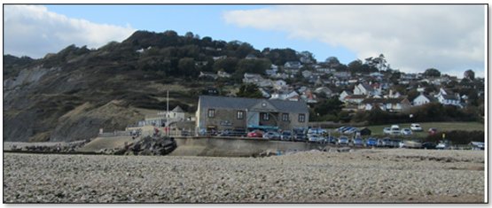
10.12 Situated in the middle of the World Heritage Coast, Charmouth has an internationally renowned fossil beach and Heritage Coast Centre (see Table 5.1 asset A1). The coastline exists because of erosion and over time it has exposed world-class geology and palaeontology. Ongoing natural erosion is fundamental to the Outstanding Universal Value of the Jurassic Coast and in order to protect World Heritage status, erosion must be allowed to continue. See 6.6 to 6.14.
However, there is also a need to protect the shoreline assets and amenities, buildings and services. See alsoJurassic Coast Trust Partnership Plan 2020-2025.
10.13 Although Charmouth has few built structures by the coast, it has a vibrant tourist economy based at the foreshore. The main building is the Old Cement Works, one of whose occupants is the Charmouth Heritage Coast Centre, a major attraction which runs various activities including fossil walks. Other occupants are fossil, craft and beach shops; a café; and the beach attendants’ office. Other structures include the NCI Lookout, the toilets, beach huts and a further café. For further detail please see the document ‘Potential Direct Losses At Foreshore Following Damage To Or Loss Of Coastal Defences’, file ref: ForeshoreImpactTable in Appendix E.
Tourism depends on the foreshore and the assets there, which in turn rely on effective coastal defences.
10.14 Several hundred thousand people a year visit Charmouth. In late 2017 this generated an estimated £15million, making tourism probably the major driver of the local economy. In early 2021 this figure was estimated at £22million for a normal year, of which 80% would be generated by accommodation (holiday parks which have been upgraded; hotels and B&Bs, and an increased number of AirBnBs; with all rentals and other prices having increased). The remaining 20% is generated by retail and Charmouth Parish Council. (For more data on tourism see 7.8 to 7.16 and Table 7.1).
10.15 The Committee on Climate Change states that the “Current approach to protecting England’s coastal communities from flooding and erosion is not fit for purpose as the climate changes” and has made major recommendations to the authorities involved in managing England’s coasts.
‘UK Climate Change Risk Assessment 2017 Synthesis Report’ notes that “priorities for the next five years recognise the need for more research and more action needed into many aspects and potential effects of coastal erosion.”
10.16 In 2011 South Devon and Dorset Coastal Advisory Group (SDADCAG) developed the current ‘Durleston to Rame Head Shoreline Management Plan’ (SMP2) (sometimes known as the Halcrow Report).
Specifically, SMP2 states that from 2025 i.e. in the medium and long term: “There would be a move towards No Active Intervention along the cliffed (sic) western part of Charmouth (with) Managed Realignment within the River Char, through providing set-back flood defences as it becomes increasingly technically difficult to maintain defences in the existing position.”
In other words:
10.17 The cliffs to both east and west of Charmouth are continually eroding: landslips, mudslides, and rock falls happen, often to a very small extent, with an occasional larger mass falling to the beach. This erosion however, is what makes Charmouth beach so important as a fossil destination, attracting many thousands of visitors every year from all over the world. High Spring Tides may lap the foot of parts of the cliff area.
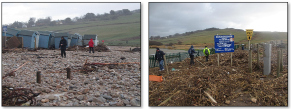
10.18 It is quite normal at present that an on-shore wind, with large waves and a high tide, can deposit sand, gravel, stones, seaweed and other debris around the foreshore buildings and the CPC car park. Occasionally, the amount deposited can be significant. See photos following 10.24.
10.19 As sea level rises, these effects are likely to increase, although slowly as sea levels are likely to rise gradually. Damage to buildings or the existing coastal defences could happen slowly, or incrementally, or possibly suddenly as a result of a major storm.
10.20 Estimates for the extent of sea level rise vary. The Royal Society has estimated a rise of 0.5 to 1 m (1.5 to 3 feet) by 2100; the UK Committee on Climate Change (CCC) (an independent, statutory body established under the Climate Change Act 2008, which provides advice to government on building a low-carbon economy and preparing for climate change) estimates 1.0m; one of CCC’s reports ‘UK Climate Change Risk Assessment 2017’ suggests rise could be 1.9m but more likely closer to 1.0m; whereas JBA Consulting (10.31) which undertook a coastal erosion survey at Charmouth in 2018, appears to suggest a possible extreme sea level rise above 3.8m by 2118.
The overall observed rise since 1901 is about 20 cm (8 inches). (Ref: The Royal Society).
10.21 Some protection of the area may be provided by the River Char which is a gravel transporting river and takes boulders, cobbles and gravels out to sea at times of flood, forming a fan/delta:
Waves transport material back to the coast to form a beach, further protecting the coast
Photo showing the proximity to the beach to the Old Cement Factory building with the Heritage Coast Centre, car parking, and the position of coastal defences.
Map 10.1 Coastal Change Risk Map
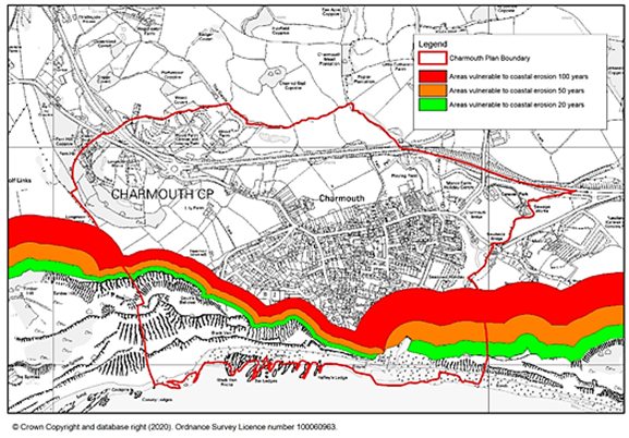
Showing projected coastal erosion i.e. where the coastline may be in 20, 50 and 100 years.
10.22 Coastal defences are a key part of coastal management, in which the land-sea boundary is protected from erosion and flooding. However, the provision of or improvement to coastal or flood defences is generally based upon potential direct impact on buildings: any other kind of impact rarely appears to be considered.
In their inquiry into coastal flooding, coastal erosion and adaptation to climate change (interim report published Nov 2019), the House of Commons Environment, Food and Rural Affairs Committee identified that there is much discussion around government priorities “Several organisations raised concerns about what they saw as too narrow a focus in Government coastal change policy on protecting residential properties. They were concerned that this approach restricted the scope for adaptation, and overlooked many other important considerations such as the needs of business or the environment.”
10.23 The impact on the village following loss of coast defences would be considerable, both directly at the foreshore as well as indirectly. Without maintenance of the existing coastal defences the foreshore area would be subject to ongoing damage until defences finally fail. It has been stated (West Dorset District Council) that when defences fail after 2025, they will be removed.
10.24 Losses at the foreshore will be considerable.
For further details of the anticipated impacts at the foreshore please see the document ‘Potential Direct Losses At Foreshore Following Damage To Or Loss Of Coastal Defences’, file ref: ForeshoreImpactTable in Appendix E.Summary of Losses
|
Photos showing what happened in 2014 storms when the beach ended up in the car park.
10.25 In the medium to long-term, such threats to the village are significant. Chapter 7 paragraphs 7.8 to 7.11, discusses tourism, while paragraphs 7.12 to 7.16 and Table 7.1 outline the issue of visitors to the village in numbers (source: Charmouth Traders). Charmouth has a significant economic reliance on tourism. Loss of tourist facilities and thus a significant drop in tourists would have a serious impact on the economy of the village and the local area.
In late 2017 Charmouth Traders, as representatives of the local businesses, researched the likely impact on Charmouth’s economy were the sea defences to be damaged beyond repair.
The most likely effect is that the Charmouth Heritage Coast Centre has to close, the beach huts are destroyed, the toilets are unusable and half the car parking spaces are lost. Firstly, Charmouth’s main attraction no longer exists – the beach and the related fossil hunting. Charmouth is a unique place. Many of our visitors come for not just a beach holiday but also to learn about the geological heritage which is of such significance that it is a World Heritage Site and contributes to our understanding of how we impact on our environment. There are many school visits to the Charmouth Heritage Coast Centre which is an extremely valuable resource for learning as well as entertainment. Secondly, there would be no cafes or toilets which would make the beach much less attractive. It would be very difficult to rebuild any of the above given the continuing storm threat. Thirdly, the loss of car parking space would halve capacity. Fourthly, Charmouth Parish Council’s two main income streams have gone so the Council would not be able to help. Let us assume that the number of people visiting Charmouth falls by 50%. (It could be worse). Holiday accommodation income could fall by 50% with a commensurate fall in employment. The effect on shops, pubs, food outlets and other businesses would be much greater as a 50% reduction in trade would make most unviable, and lead to total closure for the majority. There would also be a knock-on effect in jobs for tradesmen, cleaners, suppliers and contractors. Quote: Charmouth Traders |
In numbers, the impact was calculated as:
|
Jobs It is estimated that more than 300 jobs could be lost, roughly 50:50 full-time and seasonal. There is little alternative employment so most of these people would become long-term unemployed. (2017 estimate). Economic value Difficult to estimate but by calculating the lost income from lost employment and adding on rough estimates of businesses’ lost profitability this could well amount up to £10million per annum (2017 estimate). Then in early 2021 it was estimated that from a likely income of £22million (see 10.14) up to £15million could be lost from the local economy. Quote: Charmouth Traders |
It should be noted that the (2017) estimated loss of 300 jobs would have a significant impact on Charmouth’s population of 1300, and the surrounding area.
10.26 There will be considerable difficulty in identifying suitable sites to relocate shoreline facilities which have to be by the beach. For example, the Charmouth Heritage Coast Centre and the beach toilets have to be sited by the shore.
10.27 Within the parish, the River Char runs down the valley into the parish, under the bridge at the main road, then down to the sea. The Gwyle is a main tributary of the River Char and marks part of the northern parish boundary.
10.28 The River Char has occasionally flooded due to excessive rain, particularly if combined with a very high tide backing up the river.
10.29 Climate change projections for Dorset indicate that there are likely to be warmer wetter winters and more extreme weather events such as torrential downpours of rain. Areas around the River Char and The Gwyle may be at risk of flooding from river level rise, however short-term. In addition some land near the river is likely to be affected by tidal flooding caused by sea level rise and the loss of coastal defences. Potential damage could result in flooding of holiday parks, impacting tourism, gardens and potentially later, properties close to the river.
10.30 To lessen the effects of river flooding, SMP2 proposes some measure of ‘Managed Realignment’ possibly sited part-way along Seadown river bank. In the long term, it is anticipated that ‘Managed Realignment’ may also protect the main road by the bridge and further properties low in the valley.
Map 10.2 River Flooding Map
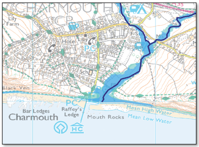
Extract from Environment Agency showing areas of flood risk (approx. 50 years hence).
Map provided by CPC
10.31 In 2018 JBA Consulting said “The Managed Realignment Zone presented covers much of the existing or historical flood plain area, and is therefore land which could be susceptible to future flooding following climate change, sea level rise or potential beach roll back. Beach roll-back will also increase the potential for waves and tides to influence further upstream within the River Char.”
10.32 LP-2.4.10 “Although there are uncertainties regarding the extent and pace of sea level rise and coastal change, the current (2011) Shoreline Management Plan has defined the over-arching strategy for managing the coast, identifying which sections of the coast are to be protected in the short (0 to 20 years), medium (20 to 50 years) and long term (50 to 100 years).” See 10.16.
10.33 In 2010 presumably as a result of SMP2 (10.16) DEFRA commissioned the Dorset Coastal Change Pathfinder Project on the 'Jurassic Coast' which undertook a detailed community consultation during 2011 relating to the Heritage Coast Centre and its possible relocation: planning for, and managing, adaptation for the future. The Pathfinder Report established that potential relocation for a new building required that relevant facilities be located adjacent to the main access to the beach and as close to the beach as possible. Five sites close to the shore were proposed and the community voted on the options. Although one of the five proposed relocation sites was voted as preferred, it was later decided that none of the proposed sites was suitable.
Links to the Jurassic Coast section of the DEFRA Coastal Change Pathfinder Programme, and also to the Parish Council’s response to the Pathfinder Report can both be found in Appendix E.
See App C for the hyperlink to the Pathfinder Report, Jurassic Coast section.
10.34 LP-ENV7(ii) “Councils will identify Coastal Change Management Areas … based on the Shoreline Management Plan and supporting evidence.” A CCMA proposes whether an area at the coast could be used for any development and of what sort. It is unlikely that residential development would be allowed. LP-ENV7(ii) also states that “The replacement of properties affected by coastal change may be permitted within a defined area agreed through a community relocation strategy as an exception to normal policy.” In the longer term sites may need to be found to relocate properties affected by coastal change or flooding. LP-ENV7(ii) provides support for such policy within a defined area through a community relocation strategy and this Plan takes the opportunity to define appropriate locational criteria.
Policy CC2 outlines the principles for the community relocation strategy, were coastal defences to be allowed to fail. It is accepted that no residential new building development will be permitted in areas of risk.
However, although relocation is permitted, there are few, if any, suitable sites within Charmouth. Relocation of coastal organisations such as the Heritage Coast Centre or premises such as the beach toilets both of which have to be next to the shoreline would seem challenging. Similarly, there are no alternative sites for car parking in Charmouth.
10.35 LP-2.4.9 notes that “Managing coastal erosion is about finding the right balance between the needs of local communities, the economy and the environment, to secure a sustainable and affordable approach to the threat while protecting natural interests”
Conclusions from the report on Dorset’s Environmental Economy, published in 2015 include:
|
10.36 The balance between allowing coastal erosion to continue in order to protect World Heritage status, yet protecting shoreline assets, amenities, buildings and services, and thus the village economy, will be challenging.
10.37 As a result of the Habitats Regulations Assessment, see link in Appendix E, it was identified that engineering initiatives to significantly improve existing coastal defences or create new defences are likely to alter the local coastal processes. “The Sidmouth to West Bay SAC relies on natural coastal processes – adverse effects on this must be avoided.” The mitigation for these risks is contained in Policy HRA1: Habitats Regulations and should be read in conjunction with policy CC2 below. See paragraphs 6.15-6.18.
Where appropriate, a vulnerability assessment would examine the effects of any proposed work on the natural balance and stability of the coastline, and whether the rate of shoreline change would be exacerbated nearby or elsewhere. (PPG 7-074-20140306).
10.38 This Plan has been developed for the future (to 2035 and later) yet the consequences after 2025 of SMP2 (Shoreline Management Plan) (10.16) as it currently stands will, in time, seriously damage the village and village economy through loss of tourism and its income.
POLICY CC2: Coastal Change and Flooding Coastal Defences
Coastal Relocation
|
10.39 Because of the threats to the village outlined in this Chapter, a Village Improvement Project has been proposed to examine the issues, seek options and take any solutions forward. It is likely that two related strands may be initiated (a) Community Relocation Strategy and (b) Managed Realignment of the river. See Appendix G.
< Previous | ^ Top | Next >