
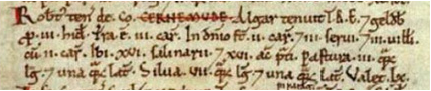
4.1 Some form of settlement has existed in Charmouth since the Iron Age. Records exist of a battle sometime between 830 and 833 where the invading Danes with 15,000 to 17,500 men, eventually overcame the local populace led by the Saxon king Egbert. The Domesday Book (1086) records that the village, which was then called Cerne Munde (Stony River), consisted of 22 households, 3 ploughlands and 16 acres (6.5 ha) of meadow, and a salt pan industry with 16 workers. The road now named Old Lyme Hill used to be the east/west Roman Road and was the main road to Lyme Regis for centuries. The origins of the village that we all know today probably date from the late 13th century, with the 'town' being created by the Cistercian monks.
4.2 The Dorset Historical Towns’ Survey (DHTS) states:
“The town of Charmouth was a deliberate foundation by the Cistercian abbot of Forde at the very end of the 13th or early 14th century, which makes it very unusual, as Cistercian houses tended not to establish new towns on their lands and only a very small number are known in England. There is some indication of prosperity in the 16th century, but the town does not appear to have expanded beyond its original limits. Charmouth has a linear plan form arranged along a single main street with regular long narrow plots along both sides. Many of the original planned mediaeval burgage plots survive. There is a series of large stone walls which define the northern limit of the town and many of the burgage plot boundaries.” Further: “Charmouth’s local distinctiveness is derived from the relationship between its plan layout, plot structure, historic buildings and its landscape setting. The layout and extent of the original planned medieval town can be traced on the ground today, and has had a strong influence on the development of individual plots in the town, particularly in its northern part.” |
See overhead photo following paragraph 8.6.
4.3 Historically therefore, Charmouth is unusual, having a Cistercian foundation and also one of the last planned mediaeval villages. It is particularly unusual in that not only is it surrounded by a wall on the 13thC mediaeval boundary but the wall and therefore the boundary, is substantially still intact and visible, and still surrounds nearly all the village: very little has been built outside the wall. This wall is known locally as The Old Priory Wall or The Abbey Wall. Research has identified very few similar villages with boundary walls from the 13th /14th centuries: the actual number is difficult to ascertain but taking into consideration date and number of village residents, there would appear to be fewer than 10 similar villages of this age within the UK. ‘Castles of Communities: Medieval Town Defences in England, Wales and Gascony’, by Prof Oliver Creighton, 2006, lists over 200 town defences but the vast majority are for towns and cities rather than villages or areas as small as Charmouth. Such walls for smaller communities like Charmouth are rare and this Plan should therefore protect this key aspect of the history and character of the village. See also NE6.32 and 6.33.
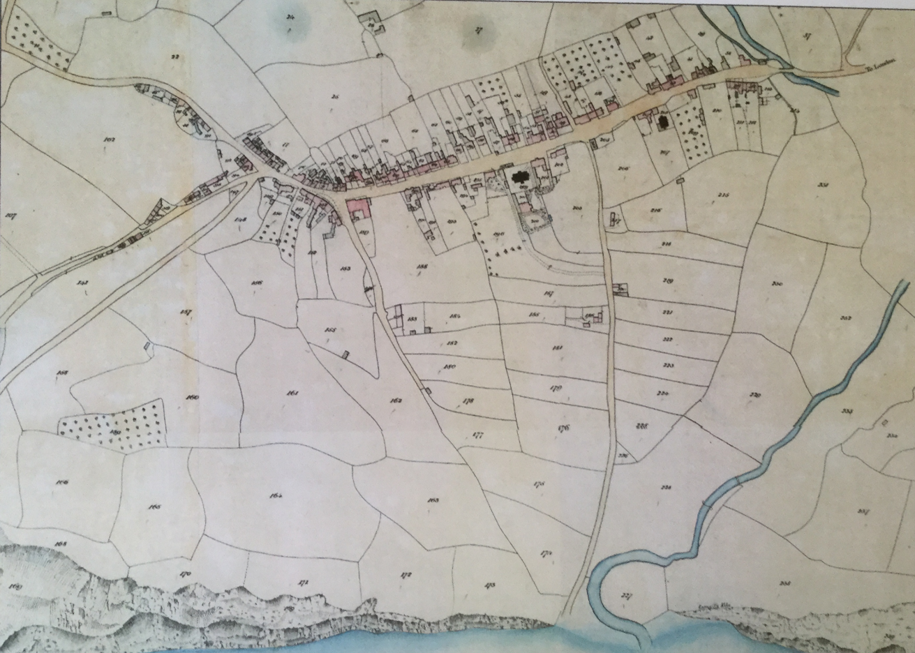
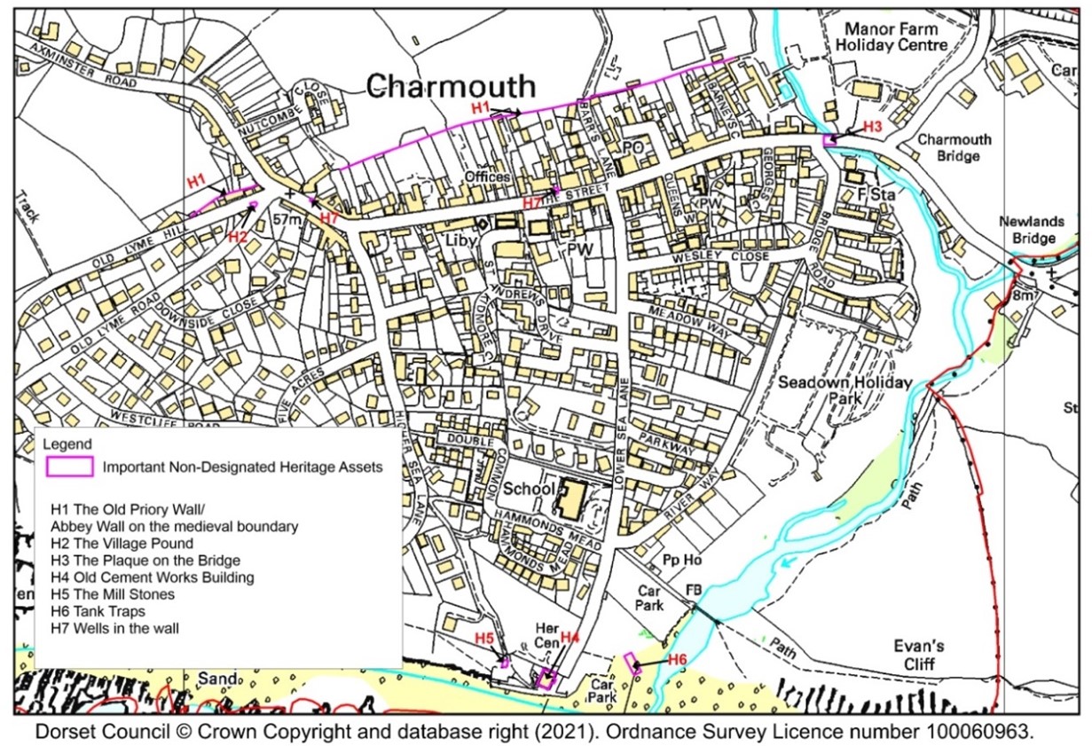
The Wall runs along the north side of the village from near the river, right up to near the corner of The Street and Old Lyme Hill, there is then a gap across the road, then the Wall continues along the back of the houses on the north side of Old Lyme Hill. The Wall forms most of the Defined Development Boundary (DDB) for Charmouth to the north other than an area to the north-west around Axminster Road. It is why there is such a straight edge to the DDB along the northern edge. See Map 4.1 and 4.22 and the photo following 8.6.
Map 4.1 Tithe Map of 1841 showing the North Wall
4.4 In 1901, with a population of 560, the village comprised houses on either side of The Street, some cottages on either side of Old Lyme Hill, a few buildings adjacent to what is now Lower Sea Lane, and little else. This has largely become the Conservation Area.
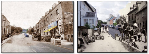
4.5 The frontages of the main street up through the village are mainly of period buildings, with some more recent replacements, infilling and additions. Photographs of the village from the mid-1800s show street views which are still very largely recognisable, with many buildings little altered.
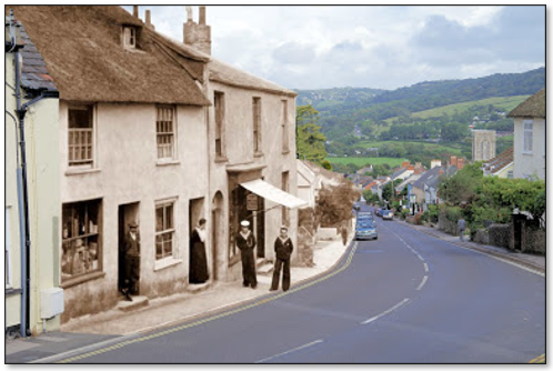
Photos merging ‘then’ and ‘now’ showing the village little changed over time.
4.6 Charmouth has an active Local History Society formed in 1999. Talks are regularly given in the village and are always very well attended.
4.7 There are nearly three dozen Listed Buildings, the majority of these fronting on to The Street, and these form the core of the Charmouth Conservation Area. All the Listed Buildings are Grade II apart from The Abbots House (formerly the Queen's Armes Hotel) which is Grade II* and has had royal visitors: Catherine of Aragon (first wife of Henry VIII) stayed in 1501, and Charles II in 1651.
See Appendix F for list of Listed Buildings.
There are two other Listed Structures which are not Buildings, both Grade II Listed:
MAP 4.2 Location of Listed Buildings in the Parish
Inserts show The Lookout and Langmoor Manor. The Toll House, at the east of the village, is the only other Listed Building outside the Conservation Area.
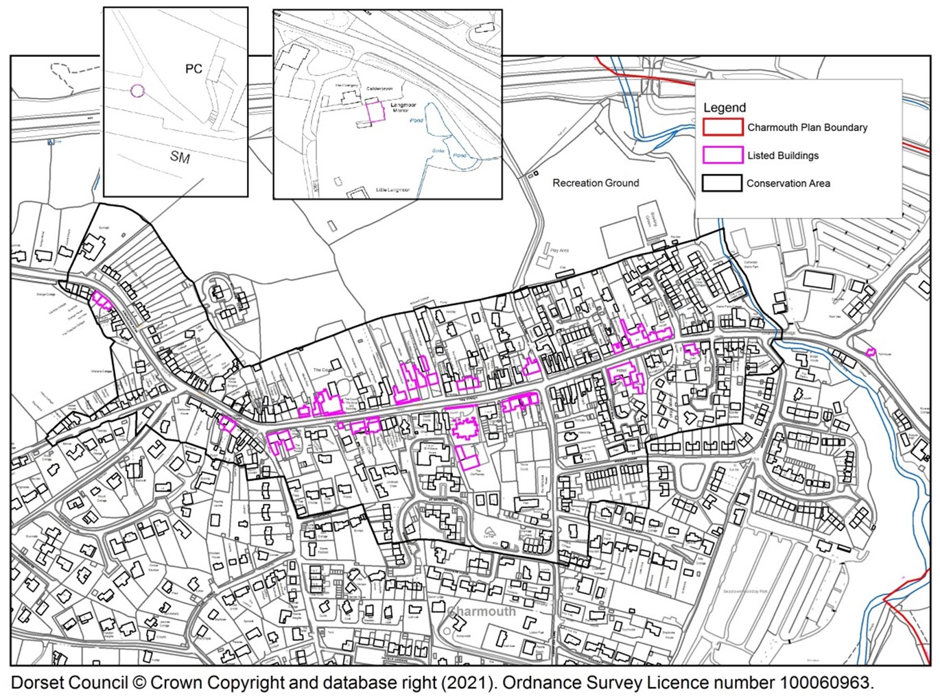
4.8 The Charmouth Conservation Area broadly comprises tranches of land on either side of The Street, part of Axminster Road, part of Old Lyme Hill, part of Barrs Lane, some of Lower Sea Lane, some of Bridge Road and the bridge at the bottom of the hill. It includes the rear gardens of properties on the north side of The Street – many of which are the historic 'burgage' plots of the settlement in earlier times. The northern edge of the Conservation Area is largely delineated by the mediaeval boundary and its wall. (See also 3.6 to 3.7 and NE6.27 to 6.29)
In addition, there are a number of buildings identified in the The Charmouth, Chideock and Seatown Conservation Area Appraisal (CCSCAA) (pp 19-25) as ‘Important Local Buildings’ including the ‘burbage walls’ whose location within the Conservation Area is considered to offer adequate protection so they have not been added to Non-Designated Heritage Assets in Table 4.1.
4.9 There are a number of structures in Charmouth which have been identified as important in their own right, whether for their historic value or their contribution to the local heritage character of the village. These are identified in Table 4.1 as Important Non-Designated Heritage Assets.
Table 4.1 is not exhaustive as previously unknown structures of significance may be identified through the planning process or through further research, for example, Dorset Historic Environment Record has recognised two locations of potential historic importance: a post-mediaeval quarry to the north of Nutcombe Terrace / south of the A35 (MDO29552); and the turnpike of Old Lyme Hill (MWX78), neither of which is now readily recognisable on the ground.
In the Village Survey, when asked about the CNP Vision, the most dominant theme from residents was that
Table 4.1 Important Non-Designated Heritage Assets
Ref |
Asset |
Description |
|---|---|---|
H1 |
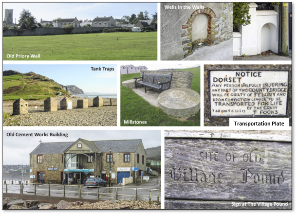
The stone wall on the mediaeval boundary, known as The Old Priory Wall |
Largely forming the boundary delineating the northern edge of what was the Cistercian settlement, the Wall runs behind houses on the Street and the lower part of Old Lyme Hill; it borders former burgage plots, and there are also walled divisions between the burgage plots. The boundary and parts of this Wall date from the 13th or 14th Century. The historic importance of the Wall and the boundary cannot be overestimated it is irreplaceable (Map 4.1). Discussed in 4.2-4.3 and 6.27-6.29. In addition to the protection of the Wall itself, protection of views of the Wall is recognised in Policy NE2. Fragmented sections of the Wall may also be found elsewhere in the village, as possibly also some remains of the original earthen bank. |
H2 |
The Village Pound |
The Pound is situated at the corner of Old Lyme Road and Old Lyme Hill. It was the site of the stocks from 1866 when they were moved from their previous location by the Church. Also LGS3, NE6.63 to 6.71 |
H3 |
Transportation Plate |
The plaque from the narrow hump-backed bridge built over River Char in 1824 has been built into the parapet of the current bridge. The historic message refers to potential “transportation for life”. |
H4 |
Old Cement Works Building (including the site of the Lime Kiln) |
Cement from local limestone was used to make tiles and similar articles from 1850. The building was finished by 1863, but only operated for a few years as transport was difficult because Charmouth had no harbour. Later uses included fishermen’s stores, Scout ‘hut’, miniature rifle range. Nowadays CHCC occupies all the first floor; with café, fossil shop, beach goods shop, craft and gift shop, and Beach Attendants’ Office on the ground floor. CHCC is listed as Asset A1 in Table 5.1. The site of the old Lime Kiln is located just behind the building. In the CNP Village Survey 85% thought something should be done to protect the foreshore buildings. |
H5 |
Millstones |
Part of the former cement workings. The millstones have been moved to The Lookout Green just west of the old cement works building. |
H6 |
Tank traps |
Dating from early in World War II, these are of the ‘anti-tank cube’ design which is unusual though not rare. Originally the ‘cubes’ were mounted on plinths to hinder being toppled. Some have been sited to mark the car park, but many have become buried under the beach, disappearing and reappearing when the beach level changes. Charmouth was an extension of the Taunton Stop Line. |
H7 |
Wells in the walls |
Piped water arrived in Charmouth in 1810. Public standpipes were installed in certain walls by The Street and the sites of some of these are still to be seen in the form of brick inserts. |
Photos of Non-Designated Heritage Assets listed in Table 4.1
MAP 4.3 Non-Designated Heritage Assets listed in Table 4.1
4.10 LP-2.1 Strategic Approach: “High priority will be given to protecting and enhancing the area’s heritage assets – including its Listed Buildings and Conservation Areas, and other features with local historic or cultural associations, particularly where they contribute to the area’s local distinctiveness.” “Development should be of high quality design to help achieve sustainable, safe and inclusive communities, enhancing quality of life for residents and visitors, and designed in keeping with or to positively contribute towards the local identity of the area.”
4.11 Listed Buildings, Important Local Buildings, Conservation Area buildings and Non-Designated Heritage Assets all contribute significantly to the character of the area. Their demolition would adversely impact on this local character, as could changes to their appearance or development on adjacent sites. It is therefore important that these structures of local value, as well as their settings, are protected, retained and respected in any new development.
4.12 The Charmouth Historic Urban Character Area evaluation on page 44 of DHTS comments on sensitivity to large scale development “The area has a high sensitivity to major change. The scale and shape of the long narrow historic burgage plots reflect a planned layout of considerable time depth, which gives this part of Charmouth its character and any further erosion of the plot pattern would have a detrimental effect on the historic character.”
4.13 LP-ENV4(i) “The impact of development on a designated or non-designated heritage asset and its setting must be thoroughly assessed against the significance of the asset.” (iv) “Any harm to the significance of a designated or non-designated heritage asset must be justified.” See also
LP-2.3 which provides further details.
4.14 Any proposal which could adversely affect any Heritage Asset, whether Designated or Non-Designated, or its setting, will require justification proportionate to the extent of the harm to its significance bearing in mind that any loss, damage or removal can never be reversed. Once lost or damaged the asset is gone forever.
The intent of Policy HH1 is therefore to ensure that while the village will continue to evolve, its special nature and important community heritage will be maintained appropriately.
POLICY HH1: Designated and Non-Designated Heritage Assets
|
< Previous | ^ Top | Next >