
3.1 Charmouth is a coastal village and civil parish in West Dorset, South West England, located at the mouth of the River Char and forming part of the popular Lyme Bay coast. It is situated along the Jurassic Coast, a World Heritage Site extending over 95 miles across Dorset and Devon. It lies between the town of Lyme Regis, two miles to the south west, and the coastal area of Seatown to the east, creating an extended coastal area in West Dorset of international geological importance, and a local source of tourism income for the area. To the north is the Marshwood Vale. Due to its significant and historic coastal features, Charmouth is located within the Dorset Area of Outstanding Natural Beauty. The main road through the area is the A35 which bypasses the village immediately to the north. The South West Coast Path and the long distance Monarch’s Way pass through the village.
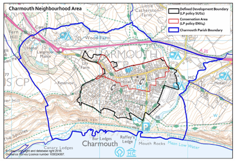
The Charmouth Parish boundary has been defined as the boundary for the Neighbourhood Plan which covers an area of approximately 221.1 hectares.
MAP 3.1 Charmouth Parish Boundary, Defined Development Boundary and Conservation Area
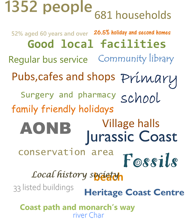
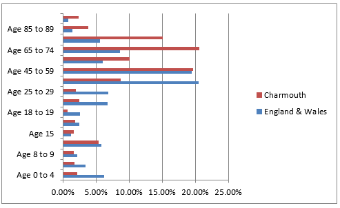
3.2 At the time of the 2011 Census, Charmouth had 681 households and a population of 1352. There has been a steady growth in the population of Charmouth over the last sixty years. See Table 3.1. The 2011 census showed that 52% of the village is aged 60 years and over which is noticeably higher than the national average (England and Wales 22.5%). See Table 3.2.
TABLE 3.1 Charmouth Population census
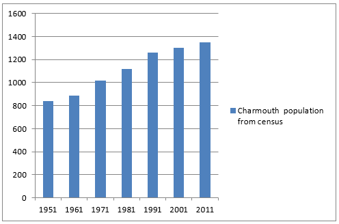
TABLE 3.2 Charmouth Age structure from 2011 census
3.3 The Village is well served with a parish church, primary school, doctors' surgery, pharmacy, community managed library, an on-call Firestation, two public houses, shops and many other facilities. There is a regular bus service linking Charmouth to Axminster in the west with its mainline station and Dorchester, the county town, to the east.
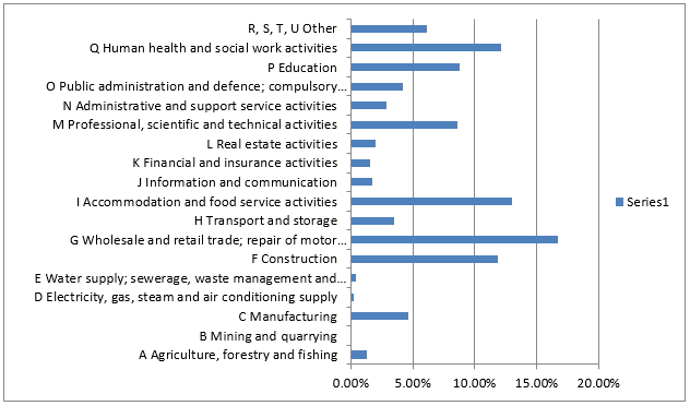
3.4 The 2011 census shows that employment in the village is diverse with the most important sectors being: wholesale and retail trade; accommodation and food services; construction; health and social care.
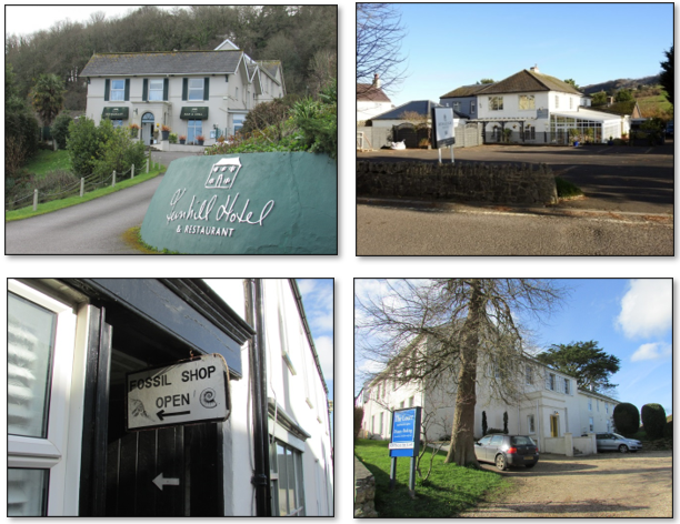
In addition, tourism plays a significant role in the area with a good choice of two small hotels, B&Bs, holiday lets, holiday parks with caravan and camping pitches as well as static caravans and lodges. This, and the activities associated with tourism, increases trade for many businesses particularly in the summer months when the village population increases significantly.
TABLE 3.3 Economic activities of those aged 16 to 74 years old from 2011 Census
Various Businesses in Charmouth
3.5 Charmouth is a socially active and inclusive community, with numerous clubs and societies for all ages and interests and various halls and meeting rooms. There is a strong sense of community with the village coming together to prevent the closure of the library in 2013 and more recently through the Changing Spaces group. This group formed to raise funds towards the restoration of the parish church, St Andrew's, and enable it to become a community venue. Charmouth Traders and the Events Committee are very active organising and supporting community events throughout the year. The village magazine, 'Shoreline', is published three times a year both in hard copy and online. The village has a traditional village notice board near the shops and others throughout the village. There is also an online Charmouth Notice Board on Facebook and a comprehensive community website www.charmouth.org both providing information about local events etc.
3.6 The village has a rich history going back to the Iron Age when a settlement was first founded. It is listed in the Domesday Book as having 22 households. By the late 13th century Charmouth was an agricultural settlement arranged on both sides of the main road between Lyme Regis and Bridport, with a stone bridge over the Char. It is one of the few new towns founded at the end of the 13th or early 14th century, one of the last in the great period of English town foundation.
3.7 In about 1503 the church was completely rebuilt perhaps indicating a population increase or an increase in prosperity in the 16th century, but following this the next 200 years were a time largely of stagnation in Charmouth. There is little evidence for growth and Charmouth remained largely dependent on agriculture and fishing. Its position on one of the major routes through Dorset means that probably it relied to a certain degree on passing trade from travellers along this road. Its strategic location historically on the main road from London to Exeter has resulted in many important visitors over the years, one being King Charles II who stayed in the village during his escape to France.
3.8 The nineteenth century saw Charmouth become a minor watering-place and holiday resort, which promoted some revival in its fortunes. This encouraged the building of villas in the town in the 1830s and 1840s. The church was rebuilt and enlarged in 1836. The Independent Chapel, now a private residence, was rebuilt in 1815.
3.9 Most people only visited for the summer season, but there was also some influx of permanent inhabitants. The population of the town increased from 369 in 1801 to 601 in 1851, but this growth was not sustained and in the second half of the 19th century the population of the town actually fell, to 560 in 1901. This decline in the late 19th and early 20th century is mirrored in many towns in Dorset, partly as a result of the general agricultural depression.
The period saw a shift away from agriculture and fishing to tourism as the primary economic activity of the town. Charmouth village became a noted resort, with visitors including the novelist Jane Austen. A major attempt at industry in Charmouth was the rather short lived cement factory built to exploit the use of limestone rocks eroding out of the cliffs. The factory was established in the 1850s, but appears to have stopped operating by 1867.
Several inns and guest houses were opened to cater for visitors. There were also a number of shops and the usual range of small industries and crafts found in towns, such as blacksmith, wheelwright, carpenter, baker, shoe and boot maker, etc.
3.10 The 20th century was a period of suburban expansion for Charmouth. The sale of the former manor lands in the beginning of the 20th century enabled the gradual development of much of the area between the historic core and the coast, as well as expansion along the Axminster Road. The population rose during this period from 575 in 1911 to 719 in 1931, 890 in 1951 and to 1320 in 2005. The rate of population increase was greatest in the 1920s, but has been climbing steadily during the second half of the 20th century.
The 1920s and 1930s saw the building of council housing on Higher Sea Lane and Nutcombe Terrace. To the south, a number of new local access roads were created after World War 2, some along the lines of existing tracks or paths, to serve the suburban expansion. New suburban housing and modern infill housing was built behind the frontage of The Street. Charmouth benefited from the 1967 Housing Subsidies Act when, in 1969, a housing subsidy was given to build 14 dwellings on Bridge Road. In 1976 the Village Plan identified sites for development: to build a new school; for lower cost medium density housing suitable for first time buyers on the old school site (Wesley Close); for low density housing behind St Andrew’s Drive. Modern infill housing continued to be built in the 1990s – 2000s e.g. Double Common, Hammonds Mead and Barney's Close in the 1990’s and Queens Walk 2002.
Charmouth remained a seaside resort and holiday destination throughout the 20th century with the main economic focus being tourism.
It also became an attractive retirement destination and functions as a dormitory settlement for Lyme Regis and Bridport.
3.11 The 20th century saw some changes made to the road layout. The Street and Old Lyme Hill is considered to be an old roman road, which formed part of the Ackling Dyke from Dorchester to Exeter. In 1924, the existing road to Lyme Regis via Old Lyme Road was closed and the present route via Fernhill was created. The bridge next to the former mill was replaced by a new one in 1957. In 1990, a new bypass was constructed to the north of the town alleviating much of the through flow of traffic along The Street. This links to Bridport and the County Town of Dorchester to the east and Axminster, Honiton and the city of Exeter to the west. Exeter airport can be reached in less than 30 minutes by road. Axminster, only 10 mins away, provides an important mainline rail link to London.
As part of the Digital Infrastructure Strategy for Dorset 2015, Charmouth has benefitted from the arrival of Superfast broadband.
3.12 The Charmouth Conservation Area, designated in 1972, incorporates a number of local historic and heritage assets for preservation, enhancement and protection. A detailed conservation area appraisal for Charmouth was published in 2009, outlining and assessing historically important and valued areas and buildings within the conservation area boundary.
Some key points highlighted in the appraisal are the landscape setting adjacent to a World Heritage coastline and within the Dorset AONB, with high hills, sea cliffs, woodland and deep, treed watercourses; mature trees and tree groups within the village that add to the quality of views in and out of the village; a substantially intact mediaeval planned layout; 33 listed building entries; about 48 unlisted buildings of quality and character, complementing listed buildings and forming parts of several coherent groups of particular interest; distinctive local building materials, notably chert and Blue Lias limestone, render and thatch that, combined with building traditions, give a strong sense of place.
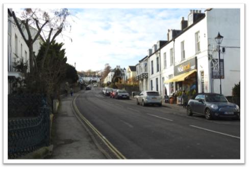
The Street – part of the Conservation Area
3.13 Charmouth is situated within the Dorset AONB. The primary purpose of the AONB designation is to conserve and enhance the natural beauty of the landscape, with two secondary aims: meeting the need for quiet enjoyment of the countryside and having regard for the interests of those who live and work there.
To the west of Charmouth are the two large masses of Fern Hill, rising to 172m and, forming a large area of unstable cliff, Black Ven and The Spittles, which extend to Lyme Regis. To the east is the impressive mass of Stonebarrow Hill, an unstable cliff, rising more steeply from the shore to over 120m.
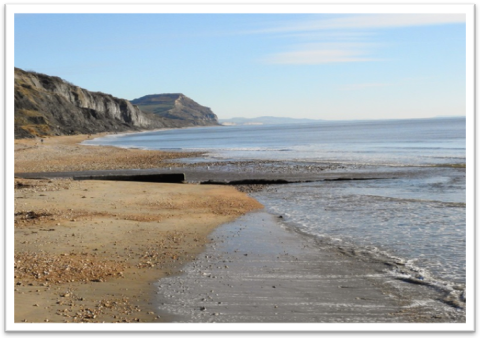
3.14 Charmouth is best known for its beach. It is within the West Dorset Heritage Coast and the East Devon and Dorset Jurassic Coast which is recognised by UNESCO as a World Heritage Site. The local coastline provides a unique insight into hundreds of millions of years of geological history and evolution, and of course is best known as the Jurassic Coast due to the large number of fossils that can be found on the beaches.
Charmouth’s Jurassic coastline
3.15 The Charmouth Heritage Coast Centre was set up in 1985 by local residents, in response to concerns about damage being done to the cliffs by fossil hunters. It is located in the upstairs floor of a long-disused cement factory on the foreshore and provides information on fossils, fossil hunting and the local coastal and marine wildlife. Facilities at the centre include interactive computers, hands-on displays, marine tanks and a video microscope. Professional wardens and volunteers are available to give advice. In 2016 the Friends of the Charmouth Heritage Coast Centre was honoured with the Queen’s Award for Voluntary Service, the highest award a voluntary group can receive in the UK. Its popularity has further increased following a BBC documentary called 'Attenborough and the Sea Dragon' in 2018 in which Sir David Attenborough helped to uncover the story of an Ichthyosaur fossil discovered in cliffs near to Charmouth. The fossil is on display in the Centre.
The Heritage Coast Centre has up to 150,000 visitors per annum in recent years.
< Previous | ^ Top | Next >