
5.1.1 It is difficult to put an exact number on the projected local need, and this would very much be guided by the availability of suitable sites. The Dorset Council Local Plan will include a housing target for the Neighbourhood Plan area, and the 2021 draft suggested that this could be 33 dwellings for the period 2021-2038, as shown in Table 2. Adjusting this to the shorter Neighbourhood Plan period (2022 – 2032) would give an indicative target of 19 homes.
Table 2
| Source | Total | Notes |
|---|---|---|
| Completions | 0 | Starts 2021 |
| Extant permissions | 5 | based on data up to 1 April 20201 |
| Strategic Allocations | 0 | |
| Major sites within development boundaries | 5 | no such sites evidenced through the SHLAA |
| Windfall allowance | 28 | monitoring data on minor sites = 2dpa |
| TOTAL | 33 | over 17 years |
5.1.2 A Housing Needs Assessment was done in 2021 based on a range of available information:
5.1.3 This concluded that it would be prudent to provide some additional housing sites to increase the housing provision over and above that which would come through windfall sites (which would normally comprise conversions / replacement buildings for housing, houses for rural workers who need to be on-site, and infill within Portesham’s defined settlement boundary). This could enable a better mix of housing that could address some of the imbalance / needs identified.
5.1.4 In particular, there is likely to be a need for smaller dwelling types / apartments, homes for first time buyers and affordable homes for rent – including those suitable for older residents. The cost of open market housing in the area during the period 2016-2021 averaged around £385,000, with the ‘first quartile’ house price (indicating the cost of the average house in the bottom half of the housing market) about £285,000 – a reasonable guide price for first time buyers. In comparison the average household income for the area during that time was approximately £42,000 – meaning that most first time buyers would be unable to afford to buy on the open market based on a 4x mortgage multiplier. The latest published housing market assessment for the wider area2 suggests that, based on demographic projections and existing stock, larger (4+bedroom) houses should only make up about 15% of the open housing mix. The following policy therefore suggests that the mix should ‘primarily’ be for smaller and more affordable dwellings, accepting that a small proportion of larger homes may be allowed.
5.1.5 It is expected that homes built should therefore fall within the types listed in Policy CBNP1, unless there are sound reasons such as constraints that would suggest otherwise. The potential for residents to work from home should also be taken into account, in light of the experience of the Covid-19 pandemic and high degree of home working that already takes place. The need for homes to be designed to enable home working is therefore expected to apply to all new homes where practical, accepting that this may require homes to be larger than standard or potentially accommodate such provision through suitable space for an outbuilding.
CBNP1. Dwelling Types
The type and size of housing permitted should primarily provide:
Homes should be designed to enable working from home, with space that can be utilised as a home office / workshop.
5.1.6 Given that the potential for windfall together with site allocations in this Plan is limited (because the area is highly constrained), it makes sense to ensure what is built genuinely helps to meet local needs as far as possible. As such, we have drafted policies to:
5.1.7 Policy ECON6 of the 2015 Local Plan supports new built tourist accommodation within an established settlement of more than 200 population (i.e. Portesham and Abbotsbury, but not Fleet or Langton Herring) and through the re-use of an existing building.
5.1.8 Whilst former farm buildings have been converted into small holiday properties for short term lets, and thereby increased the potential for tourism income, it is important that the number of holiday homes does not become excessive, particularly within the settlements where a higher level of vacancies and transient resident population has a more noticeable social impact. In Abbotsbury, Fleet and Langton Herring, the latest available data (shown in Table 33 ) suggests that about 1 in 4 homes are in use as second homes or holiday lets, which significantly reduces the number of local residents that live in the community year-round. It therefore makes sense to limit the number of new homes being used as holiday / second homes within these settlements, if we are to retain a reasonable balance between the local residents and more seasonal holidaymakers. The conversion of holiday lets to use as a main residence within these settlements4 will also be supported to help address this imbalance.
Table 3
| Parish | % Vacant homes | % Second homes |
|---|---|---|
| Abbotsbury | 14.5% | 28.6% |
| Fleet and Langton Herring (combined data) | 24.2% | 18.9% |
| Portesham | 8.1% | 8.8% |
5.1.9 The data does not indicate that that the level of second / holiday homes ownership in Portesham is significantly different to the rest of Dorset to justify special measures. However this should be monitored, and the Parish Council will keep under consideration the need to include Portesham, including its outlying hamlets, within this policy in a future review of this Plan.
CBNP3. Holiday / second home restrictions
In the parishes of Abbotsbury, Fleet and Langton Herring, any new dwelling (including through conversion or replacement of existing buildings, or lifting of holiday let conditions) must be used as the principal residence. This can be achieved by the use of a legal agreement that will restrict its occupancy to that of a principal residence; defined as the sole or main residence of the occupier for the majority of their time. Occupiers will be required to keep verifiable proof that they are meeting this obligation and make it available when requested for inspection by the Local Planning Authority.
The lifting of holiday let restrictions within the settlements of Abbotsbury, Fleet and Langton Herring will be supported provided that the accommodation would be suitable for full time occupancy.
5.1.10 The justification for building affordable homes is to meet local needs, in line with the 2015 Local Plan policy HOU2. As such, the allocation of affordable housing will be prioritised to those with a housing need and a local connection (i.e. an established residency or employment connection to Chesil Bank). The housing provider will be expected to undertake their initial marketing aimed exclusively to applicants with a local connection, whether for rental-only properties or for those with a purchase element, and for subsequent re-lets/sales.
5.1.11 The Local Plan makes clear that the provision of affordable housing should be ‘tenure blind’ i.e. not differ in style and design so as to be obvious which homes are provided as affordable housing and which are open market. This point is included in our policy for the avoidance of doubt.
CBNP4. Affordable Housing – Local Connection
Where affordable housing is provided, this should be tenure-blind and made on the basis of prioritising people in housing need who have a local connection to the Neighbourhood Plan area (based on the local connection criteria of the Dorset Housing Allocations Policy), and should be subject to a suitably worded condition or legal agreement to ensure that the housing will remain affordable in perpetuity for such people.
5.2.1 The independent site options assessment identified five potential housing sites that were considered “possible” for allocation, subject to certain issues being resolved or mitigated.
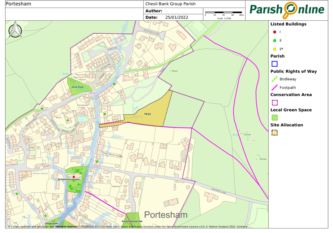
5.2.2 Of these, our consultation on the site in Portesham east of North Mead Farm (PO-03), which would deliver some affordable homes, indicated that there was a reasonable level of local support for this proposal, although there were some concerns raised regarding surface water flooding and access and traffic onto Front Street, and the impact on the setting of Trafalgar House (a Grade II Listed Building to the north side of North Mead Farm).
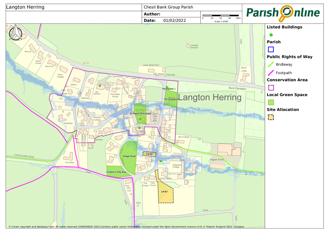
5.2.3 The three “possible” sites in Langton Herring had a more mixed level of support locally. The site adjoining 4 Court Close (LH-02) had a significant number of people who were neither for nor against it, and the main concerns relating to parking and design, so this has been included as an allocation with these issues to be addressed through the planning application process. Whilst respondents did raise concerns regarding the site at Higher Farmhouse (LH-01), these mainly reflected the scale of development proposed, with many indicating that a smaller number would be better. The landowner has since confirmed that they now intend to build just 1 dwelling, and this is reflected in the proposed allocation. There was a very high degree of local concern regarding the site between Shop Lane and Roses Lane (LH-04) primarily due to the impact development here would have on the entrance to and character of the village. Recognising the sensitivity of this site (within the Conservation Area and visible to Grade II listed Village Pound.), it has not been included as an allocation.
5.2.4 There was also a reasonable degree of local support for a site in Fleet adjoining Stone Cottage (FL-05), but this was rejected by the Examiner as being an unsuitable location for further development, and therefore does not feature in the final version of this Plan.
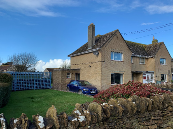
Land east of North Mead Farm,Portesham
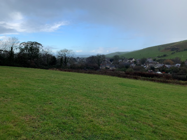
5.2.5 The site falls outside Portesham’s defined development boundary. Land to the south was given outline planning approval for 5 dwellings in September 2020, with the need for housing (in the absence of a 5 year housing land supply) weighing heavily in favour of that site’s development. The officer report for that site recognised the need for the site to deal with surface water run-off, and therefore a requirement for a surface water drainage scheme was included within the approval. In any event, safe access and escape routes should be designed into the scheme to avoid possible difficulties in accessing the site at times of heavy rainfall and surface water run-off.
5.2.6 This site is located within the conservation area and forms an important component of the open perspective of this part, sloping up to the east. Archaeological evaluation in the area has also highlighted the potential for Iron Age, Romano British and medieval finds, with a possible 7th Century cemetery located in the wider area5.
5.2.7 A public footpath (S37/4) runs along the southern edge of the site, heading east and then south to connect to Winter’s Lane. Given these factors, it is considered that some development may be suitable on the western part of the site (assessed as between 3 – 6 dwellings), but the exact number will depend on more detailed design work, with attention paid to how development can be successfully integrated into the landscape and settlement form.
5.2.8 The design will also need to address the removal of the existing spoil heap (which is believed to be a legacy from the construction of the houses to the front), and surface water drainage issues that apply to this site (as if not addressed this could increase flooding within the village) – with reference to the Flood Investigation Report for Portesham that was drawn up in response to the serious flooding in January 2019.
5.2.9 The site was put forward by the landowners to deliver affordable housing, with some open market housing. Given that no affordable housing was delivered as part of the previous development on the land to the south (which was in the same ownership) but would have been included had this site been considered at the same time6 , it would be appropriate to require 50% of the new homes to be affordable. The landowner has also indicated that they wish the open market homes to be prioritised to people with a local connection to the area, which they will be able to secure through a suitable legal covenant (but is not something that can be made a planning obligation as ‘necessary’).
CBNP5. Land east of North Mead Farm (PO03)
Land east of North Mead Farm, Portesham (PO-03) is allocated for a mix of affordable and open market homes, with the affordable homes comprising at least 50% of the total dwellings.
The total number of homes will depend on the detailed design, which will need to respect the character of the Conservation Area and local views across the site into and out of the village, including from public footpath S37/4. The type and size of homes will accord with Policies CBNP1 and 4, and designed in accordance with Policies CBNP22 to 31.
Any development proposals for this site are to be accompanied by the results of an archaeological evaluation, to be carried out in accordance with a Written Scheme of Investigation to be agreed in advance with the Council’s Senior Archaeologist.
The existing spoil heap should be removed and the design based on underlying contours.
A drainage scheme must be included that attenuates the surface water so that discharges from the site do not exceed existing greenfield runoff rates (including a climate change increase of 40% and a 10% allowance for urban creep), and ensures safe access and escape routes at times of heavy rainfall and surface water run-off, in accordance with Policy CBNP20.
Land at Higher Farmhouse, Langton Herring
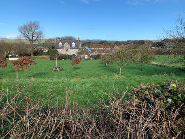
5.2.10 This site is well related to the existing settlement of Langton Herring, as it falls within the grounds of Higher Farmhouse on the south-eastern edge of the village. It is some distance from the historic core of the village and associated Conservation Area, and not visible from the Listed Higher Farm Cottage on Shop Lane due to intervening development, but would be visible from the footpath to the south. However the site is on an area of recorded earthworks relating to part of the shrunken settlement of Langton, most likely it is on or around the site of the medieval manor house7
5.2.11 The are a number of trees within the proposed site - aerial photographs indicate that these were planted between 2002-2005, with space for a vehicular track through. The south-eastern portion of the site is not treed and it is anticipated that the dwelling would be located in that position, enabling most of the trees, particularly along the site perimeter where the root zones can be protected, to be retained.
5.2.12 Access would be via a narrow, single lane track to the existing dwelling which could not easily be widened due to existing properties, and the landowner has agreed to limit development to 1 additional dwelling.
CBNP7. Land at Higher Farmhouse (LH-01)
Land within the grounds of Higher Farmhouse, Langton Herring (LH-01) is allocated for one dwelling, to be accessed from the existing access to Higher Farmhouse (improved as necessary to meet highways standards).
Any development proposals will need to be accompanied by the results of an archaeological evaluation carried out according to a Written Scheme of Investigation agreed with the Council’s Senior Archaeologist.
The layout and design of the development should enable the retention of most of the tree cover, particularly along the site perimeter. The type and size of dwelling will accord with Policies CBNP1 and 3, and designed in accordance with Policies CBNP22 to 31.
Care should be taken to consider the impact of the dwelling and any outbuildings in views from the public footpath to the south (S26/6), with the scale, massing and materials used to ensure that any new building is not prominent in the view.
Land adjoining 4 Court Close, Langton Herring
5.2.13 This site is an infill plot located within the village of Langton Herring. It lies diagonally opposite the Grade II Listed Higher Farm Cottage, and could potentially impact on the significance of its setting, but as the plot is created through the subdivision of a larger plot in a row of semi-detached houses it would be seen in this context. There is also evidence of a deserted settlement site with earthworks and possible fishponds in the vicinity.
5.2.14 Given the group character of this row of dwellings, it is important that the built form continues to the side of the existing dwelling, rather than behind, in order to retain the characteristic building line and form of the street, and also the relationship of the rear gardens with the green space to the rear. In doing so it will also be important to ensure that there is enough parking provided for both homes, given the limited width and problems with on street parking along Shop Lane. Impacts on neighbouring properties including privacy/ overlooking and loss of daylight will also need to be considered as part of the detailed design.
5.2.15 Whilst the Environment Agency maps indicate the potential for surface water flooding through the site (from east to west) there is an existing surface water drain to the front of the site (which will need to be maintained) and it is understood that the surface water modelling has not been updated to reflect this. There is no local knowledge of any recent flooding in this location.
CBNP8. Land adjoining 4 Court Close (LH-02)
Land adjoining 4 Court Close, Langton Herring (LH-02) is allocated for one dwelling, to be accessed from Shop Lane. The type and size of dwelling will accord with Policies CBNP1 and 3, and designed in accordance with Policies CBNP22 to 31. In particular the building line should be respected with the dwelling inline rather than to the rear of the existing housing row, and adequate parking provision incorporated within both plots, without dominating the street scene. In addition the height should not exceed the height of the buildings to either side.
Any development proposals should demonstrate that harm to the setting of potentially affected designated heritage assets, such as Grade II-listed Higher Farm Cottage and the Conservation Area, has been avoided or minimised.
development proposals for this site are to be accompanied by the results of an archaeological evaluation, to be carried out in accordance with a Written Scheme of Investigation to be agreed in advance with the Council’s Senior Archaeologist.
A drainage scheme should be included that ensures the existing surface water drain remains adequate to deal with the potential for flood risk.
5.3.1 In March 2022, at a late stage of drafting this plan, Natural England identified a new requirement for nutrient neutrality that would impact on our Neighbourhood Plan area, which relates to the Chesil and The Fleet SAC and SPA which is understood to be suffering from excessive nitrogen and phosphorus levels. This has been considered through the Habitat Regulations Assessment, and it is recommended that we include a policy to cover this matter
5.3.2 In Natural England’s view any further release of nutrients from development, through discharge of treated sewage effluent, will in combination with other factors harm this important wildlife area. This is an important consideration since a plan cannot legally be adopted, or a project consented, if it will have an adverse effect on the integrity of a European site ‘in combination’ with other plans and projects. While the amount of growth in the Neighbourhood Plan is very small (so small that it may not translate at all into an actual net change in the local population) it is nonetheless captured by the new requirement to undertake calculations to determine if the growth it is allocating is likely to be nutrient neutral.
5.3.3 Advice on how to achieve nutrient neutrality in relation to developments within this area is likely to be worked up by Dorset Council in consultation with Natural England, as they have previously when a similar issue arose in relation to Poole Harbour. With the following policy requirement in place, the Neighbourhood Plan will contain a sufficient policy framework to protect the SAC / SPA from nutrient pollution.
CBNP9. Ensuring Nutrient Neutrality
Applications for net new residential development within the Neighbourhood Area will only be supported if they are able to demonstrate nutrient neutrality and, where necessary, deliver appropriate mitigation to ensure this requirement is met’..
5.4.1 This was our first attempt at developing a Neighbourhood Plan, and what has become clear is whilst there is general support to see more affordable housing in the area, it is not easy to find sites which are suitable and which could be developed at a reasonable cost to keep the housing affordable (which greatly reduces the value of the land well below many landowners' aspirations). Further effort is needed to work with the community and local landowners to identify more suitable sites, and have in place a clear mechanism for bring these forward in a way which will deliver affordable housing for use by local people.
5.4.2 Having explored this issue and met with the Housing Enabling Team at Dorset Council, an obvious first step would be to see if we can get enough interest to set up a Community Land Trust. This would be a not-for-private-profit organisation that is:
5.4.3 Once a suitable site is identified by the Trust in agreement with a local landowner, the Trust could then partner with a Housing Association to bring forward the homes. But the land would belong to the Trust, who could set the criteria or be involved in how the homes are allocated. There are examples of similar projects elsewhere in Dorset, including Bishops Caundle, Buckland Newton and Toller Porcorum.
5.4.4 If the site would be for 100% affordable housing then it may be possible to bring this forward under the existing Local Plan policies as a rural exception site. If it could only be developed with a mix of affordable and open market housing then it could be considered through a future review of this Neighbourhood Plan.
Project 1.
The Parish Council will support local volunteers to set up and run a Community Land Trust for the benefit of the Chesil Bank community, and work with local landowners to identify further potential sites for affordable housing.
1This erroneously includes a permission for 3 units at Rodden Barn Farm (WD/D/17/002752) that has a holiday let condition on and would not therefore count towards the demand or supply.
2Dorset and BCP Local Housing Needs Assessment, November 2021 – with particular reference to Table 9.23
3Data was sourced from the 2011 Census and Dorset Council’s Second Homes Background Paper (undated but published early 2021) Appendix 1.
4As there are no defined development boundaries, what is within the settlement will be a matter of planning judgement but should in all cases be clearly related to the main settlement and not to isolated clusters of development in the wider countryside.
5More details on local heritage are available in the Dorset Historic Environment Record
6The planning application on the site to the south (WD/D/19/001849) was not required to provide affordable homes due to the limited size (National Planning Policy suggests that in AONBs affordable housing should not be sought on sites of 5 or fewer units), but would have had to (at a rate of 35%) had the combined site been considered.
7Dorset HER ref: MDO1327
< Previous | ^ Top | Next >