
AECOM
Consultancy providing technical support for Neighbourhood Plans
AONB
Area of Outstanding Natural Beauty – nationally important landscape (of the same status as a National Park) designated by Natural England
Affordable Homes
Affordable housing is defined in the National Planning Policy Framework, but in layman’s terms includes:
Those able to rent or buy must be unable to afford adequate housing locally on the open market, and may need to prove a local connection to the area. In most cases there are provisions in place to ensure that affordable remains affordable.
Conservation Area
An area designated under Planning (Listed Buildings and Conservation Areas) Act 1990 as being of special architectural or historic interest the character or appearance of which it is desirable to preserve or enhance.
DDB (Defined Development Boundary)
A defined development boundary is a line that is drawn on a plan around a village, which reflects its built form. It is used as a policy tool reflecting the area where a set of plan policies are to be applied. Areas outside this boundary or settlement line are considered to be countryside, where there are greater controls to prevent unnecessary development.
Eutrophication
Eutrophication is the process by which an entire body of water, or parts of it becomes progressively enriched with minerals and nutrients. This can become a problem in marine habitats such as lakes as it can cause algae blooms which could produce toxins harmful to higher forms of life
Geomorphology
Geomorphology is the study of landforms. Their processes, form and sediments at the surface of the earth
Listed Building
Buildings and other features of special architectural or historic interest listed by the Secretary of State for Culture, Media and Sport on the advice of Historic England. Graded I II* and II to indicate their relative importance.
Local Plan
The main development plan document that sets planning policy for the area (in this case Dorset Council), which provide the framework for making decisions on planning applications.
NPPF (National Planning Policy Framework)
The main document containing national planning policy set out by Government
Nucleated
A nucleated village is formed or gathered around a central area.
RAMSAR
An international treaty for the conservation of and sustainable use of wetlands. It is named after the city of Ramsar in Iran where the convention was signed in 1971, and came into force in 1975.
SAC (Special Areas of Conservation)
These are internationally recognised wildlife areas, designated under the Habitats Directive by the UK Government, with the aim of which is to conserve natural habitats and wild flora and fauna.
Scheduled Monuments
Scheduling is the oldest form of heritage protection used by Historic England. Protection Act. It began in 1913 although its roots go as far back as the 1882 Ancient Monuments Protection Act, when a "schedule" of prehistoric monuments deserving of state protection was first compiled.
SEA (Strategic Environmental Assessment)
A formalised, systematic and comprehensive process of evaluating the environmental impacts of a policy, plan or programme and its alternatives.
Setback
The term Setback usually refers to the distance a house or structure must be from a property line. For example a local planning rules might require a house to be no closer than 5 metres from the front property line
SPA (Special Protection Areas)
These are internationally recognised wildlife areas, designated under the Birds Directive by the UK Government, to protect sites which are particular important for birds. Chesil Beach and the Fleet is a Classified SPA
SSSI (Site of Special Scientific Interest)
A Site of Special Scientific Interest is a formal conservation designation. Usually it describes an area that's of particular interest to science due to the rare species of fauna or flora it contains or perhaps important geological or physiological features it contains within its boundaries
Toft
A medieval homestead, which generally means that it is an isolated farmhouse along with its outbuildings.
Voussoirs
A voussoir is a wedge shaped element typically of stone which is used in building an arch or vault. Each voussoir must be precisely cut so that it presses firmly against the surface of adjacent blocks. The central voussoir is called a keystone.
Table 5
| View | Description |
|---|---|
Views to St Catherine's Chapel as an important local landmark, and from the Chapel towards Abbotsbury and the coast Referenced in Conservation Area Appraisal - from St Catherine’s Chapel looking north and NE over the village to Wears and White Hills, with the Church tower and Tithe Barn particularly prominent and, behind to the south, extensive views of The Swannery, Fleet and Chesil Beach |
Travelling in an easterly direction as you approach Abbotsbury on the B3157 from Burton Bradstock, St Catherine's Chapel is very prominent set high on a hilltop overlooking Chesil Beach and the Isle of Portland. This 14th century chapel was built by the monks of the nearby Abbotsbury Abbey as a place of pilgrimage and retreat, and is likely to have been used as a beacon or sea-mark after the Dissolution, helping to may have ensure its preservation. The chapel is open to the public and it is a popular destination amongst walkers. Many visitors seek out the "wishing holes" where local women used to pray to St Catherine and ask her to find them a husband. The walk up to the Chapel provides spectacular views of not only Chesil Beach and The Fleet, but also of the village of Abbotsbury and the Abbey ruins. To the east you can see the Isle of Portland and see how it curves downwards like a giant wedge. Look west and observe the rolling cliffs of West Bay, Golden Cap and beyond 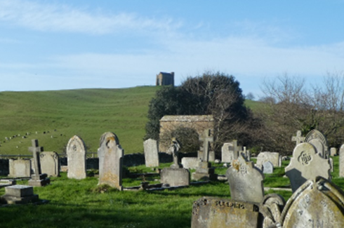
|
Views from Abbotsbury Hill towards Chesil Beach and The Fleet Referenced in Conservation Area Appraisal - from the slopes of Wears Hill, looking SE on the B3157: the classic view, much photographed and used in publicity material, of the sweep of the escarpment, Chapel Hill and Chapel, coast as far as Portland and Weymouth Bay, and the village tucked into its undulating terrain |
Travelling in an easterly direction from Burton Bradstock on the B3157 towards Abbotsbury, there lies one of the most spectacular coastline views in England. From the layby, before you start the descent into Abbotsbury, you are drawn initially to the sight of Chesil Beach, which is a long pebble barrier that stretches for 18 miles along the Dorset coast between Bridport and Portland. On the far side of the beach are the waves of the English Channel and on the near side, the body of water known as The Fleet. The Fleet is the UK's largest saltwater lagoon. It is a sanctuary from wild coastal weather allowing wildlife to thrive. In the foreground lies the Swannery, whose existence can be traced back to the monastery. The monks farmed a population of swans here in their natural habitat, which provided a source of income and food for their banquets. Mute swans have lived naturally on The Fleet for hundreds of years, the sheltered waters and eel grass offering an ideal habitat. Today, the Swannery welcomes thousands of visitors annually, particularly during the breeding season in May and June. The calm water that suits the wildlife also attracted the military. With its rural setting and just nine miles from Portland's old naval base, the Fleet's length and calm waters made it the ideal location for testing Barnes Wallis's bouncing bombs during the second world war, which were eventually used to destroy a series of dams in Germany's Ruhr valley. 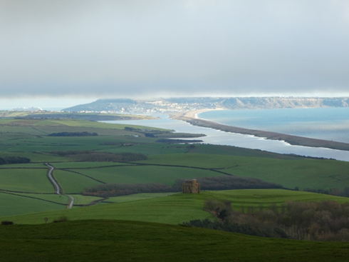
|
Views to Hardy's Monument as an important local landmark, and from the monument towards Chesil and The Fleet |
Located on the northernmost part of the Neighbourhood Plan area, on Black Down some 170m above Portesham village, is Hardy's Monument. The monument has been used as a landmark for shipping and is visible from a distance of 60 miles and is open to the public during the peak season, where visitors can climb 120 steps to the viewpoint at the top. From the top of the monument it is possible to see the coast from Start Point, Devon to St Catherine's Point on the Isle of Wight, both of which are 56 miles away, as well as the remarkable panorama of Chesil Beach and Fleet Lagoon. In the whole of that view there is nothing of any significance which indicates that the viewer is living in the 21st century. This monument is not dedicated to the famous Dorset author, but is a monument to the memory of Vice-Admiral Sir Thomas Masterton Hardy, Flag Captain of HMS Victory at the Battle of Trafalgar built in 1844. Admiral Hardy lived in Portesham and his family owned the Portesham estate which stretched from the middle of Portesham to Black Down. It was in Hardy’s arms that Lord Nelson died, saying the immortal words "Kiss me Hardy". Perhaps Thomas Hardy had this view in mind when he wrote the following lines in his poem 'Wessex Heights' “There are some heights in Wessex, shaped as if by a kindly hand For thinking, dreaming, dying on” 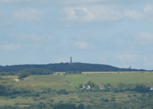
|
Views to / along Chesil Beach and Fleet Lagoon |
Chesil Beach is not nationally known by the layman for what it is, one of the wonders of Britain. The Fleet itself is too important in natural history terms for boating to be permitted within it. Having no road along its shore it is not easily visited. That makes the area all the more valued for quiet recreation for those who do find it. Viewed from the sea shore, this sense of timelessness is no less complete. The Beach forms a sweeping and totally undeveloped foreground to the Dorset hills. Viewed from Hardy’s Monument, the Fleet forms part of a remarkable panorama from Portland to Golden Cap. 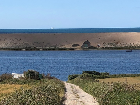
|
Views towards Lyme Bay |
Dorset is renowned for its beauty with the perfect mix of countryside and coast and the views to the west towards Lyme Regis Bay from a number of viewpoints in the parish offer stunning views of the rolling hills, dramatic coastline and cliffs, which surround us. In the foreground before Lyme sits Golden Cap, and at 191m above sea level is the highest point on the South Coast of England. Lyme Bay can be viewed from several viewpoints within the Parish, most notably from Bishop’s Road, Portesham Hill, Hardy’s Monument and St Catherine’s Chapel. |
Views from Portesham Hill towards the coast |
Portesham Hill runs steeply due south from Black Down Hill into Portesham and offers a bird's eye view of the Fleet Lagoon and Chesil Bank. For the visitor who might be taking the road for the first time it comes as a pleasant surprise and for those who live here it offers a spectacular welcome as you get that first glimpse of the coast that signals you are back home! 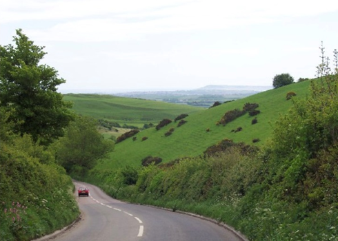
|
Views of the Tithe Barn in Abbotsbury, as an important local landmark |
The Tithe Barn was formerly part of Abbotsbury Abbey and dates back to 1400. It is thought to be the largest thatched building in the world, 272 feet long by 31 feet wide. The huge bulk of the barn dominates the outlook from the isolated ruins of the Abbey. As the only remaining building of the Benedictine monastery it is a treasured part of Abbotsbury's landscape. |
Views from the South Dorset Ridgeway towards the coast |
The South Dorset Ridgeway offers not only fantastic views of the Jurassic Coast, but also of the inland scenery of river valleys, chalk downs, villages and farmlands. The route runs to the north of the Chesil Bank Parish offering views towards the outlying hamlets of Friar Waddon and Coryates and the villages of Portesham and Abbotsbury. 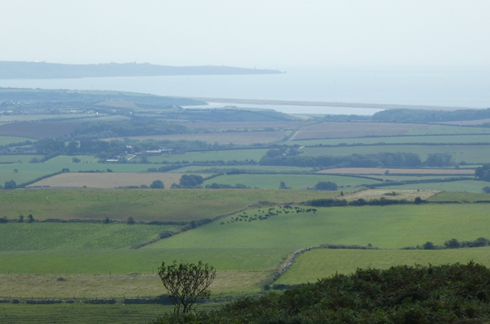
|
Views from Bishop's Road descending into Abbotsbury and towards the coast Referenced in Conservation Area Appraisal - from Hands Lane SW over Church St, the Church tower and Tithe Barn, with the strongly contoured Chapel Hill and Chapel forming a backdrop |
Bishops Road is a single track road which descends from the top of Portesham Hill to the village of Abbotsbury (and becoming Hands Lane at the Abbotsbury end). The road is extremely steep in places and twists and turns in others. For those who choose to take this route into Abbotsbury, whether by car, on foot or cycle, they are rewarded with breathtaking views of the coast and Abbotsbury itself. It is not the easiest road to negotiate by car and it is hard to keep your eyes on the road rather than on the view! The view is even more spectacular if taken just as the sun is setting, not to be missed. 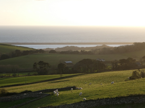
|