
A thriving rural community such as Buckland Newton depends, in part, on retaining local services and community facilities such as its school, shop and public house. Housing is essential to ensure that there is an active community of sufficient size to ensure these local facilities remain viable. Looking back to the mid 1990s there has, on average, been 2 or more homes built every year in our parish.
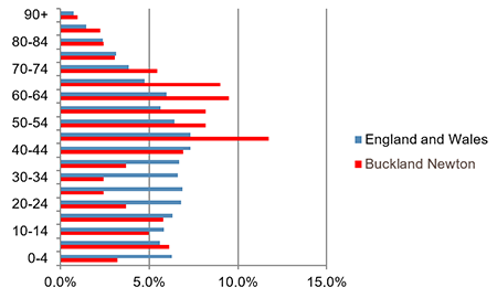
Figure 2 below, demonstrates the skewed age structure in Buckland Newton, with well below the England and Wales average in the 20 - 39 age group, and well above average in the 45 – 69 age group. Lack of affordable housing may well be a factor for the 20 – 39 age group, and this will inevitably impact on the school numbers and its long term sustainability.
Fig.2 - Age Structure 2011 Census data
Housing growth
Fig.3 - Buckland Newton Parish Households
Occupied households only - does not include 2nd homes, etc
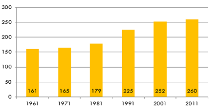
Fig.4 - Buckland Newton Household Occupancy
Census data
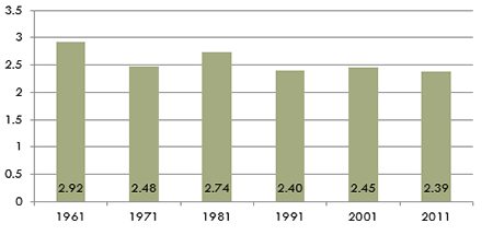
Over the last 50 years the local population has grown. When we wrote this plan there were about 260 households living in the parish. This is more than 60% greater than the number of households living here in the 1960s. Household sizes have got smaller, so there has not been quite the same level of increase in actual population – which grew by about a third in the same period.
Fig.5 - House types
2011 Census data
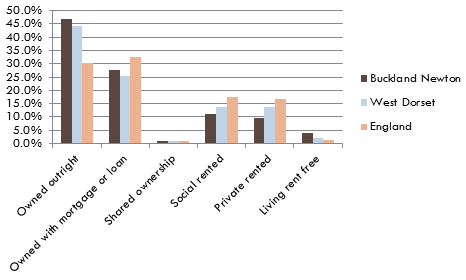
74.6% of properties in Buckland Newton parish are occupier owned, compared to 69.5 % in West Dorset and 62.9% in England. 20.8% of properties are social or private rented compared to 27.6% in West Dorset and 34.3% in England
Fig.6 - House size by number of bedrooms
201 1 Census data
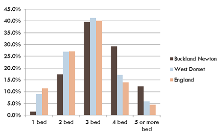
The 2011 census also highlighted that there were comparatively more ‘larger’ homes than typical, with 41.5% of households living in 4 or more bedroom homes. This compares with 22.9% in West Dorset and 18.5% in England. 18.1% had one or two bedrooms, compared with 36.0% in West Dorset and 38.6% in England.
Responses from the public consultation in Autumn 2012 showed there was good support for continuing the previous rate of development of between 2 and 4 per year. General feedback from the public consultation indicated that any future development should be spread throughout the parish rather than be concentrated within Buckland Newton village. There was a strong feeling that any future development should be gradual, should not change the character of the parish and, being in the AONB, should not be visually intrusive.
The local plan’s strategy is that in the more rural areas such as the area covered by this Neighbourhood Plan, development will be focused primarily at the larger villages (and it lists Buckland Newton as one such village), and should take place at an appropriate scale to the size of the village. These larger villages are considered more sustainable due to their size and general range of community facilities and potential for employment. The strategy does not support new housing in areas away from existing settlements. The local plan defines a development boundary for the village of Buckland Newton, within which housing may be built (even if the site is not specifically allocated). However there are very few sites with development potential within the existing defined development boundary. So as part of the preparation of this plan sites outside the development boundary were investigated. 20 potential housing sites (suggested by or in agreement with the relevant landowners) were considered, and subjected to planning checks and consultation. As a result 9 new sites are included in the plan (the evidence base to this plan includes a separate report on site selection process and the public consultation). Some of these will provide open market housing (and will make a financial contribution towards affordable housing to be provided in the local area), some will provide affordable housing for local needs, and some a mix of both.
After a great deal of debate and discussion it was concluded that the phasing of development is not easy to achieve. There is no guarantee that the schemes will be built, particularly as potential sites are controlled by many different landowners. Also, where there is a specific local need it may not be appropriate to restrict the timing of the development, as this would potentially threaten the local business or have social consequences in the case of affordable housing.
Policy H1: Location and Amount of New Housing
New housing development may take place within the defined development boundary of Buckland Newton and on sites allocated in this neighbourhood plan (as shown on the Policies Map). In addition, homes to meet specific needs for local, affordable housing or rural workers may be permitted as set out in the local plan. The sites in this neighbourhood plan have the potential to provide sufficient land for up to 35 new homes (an average of 2.3 per year) over the plan period of 15 years.
© Crown copyright and database right (2017). Ordnance Survey Licence No. 100051694
As a matter of clarification, please note that the Defined Development Boundary (DDB) for Buckland Newton has been extended to include Housing Site Allocations and that this extended DDB takes precedence over the DDB for Buckland Newton defined in the Adopted West Dorset, Weymouth and Portland local Plan (2015).
The type and size of new housing, including affordable homes
The consultation also showed that in developing new homes, we should make sure that these provide affordable homes for local people – ideally at least half of the homes built should be affordable.
Lydden Meadow affordable housing scheme completed 2011(www.lyddenmeadow.co.uk)
The Housing Needs Survey carried out by the Parish Council in March/April 2014 showed a need for smaller homes, and this too was supported through the consultation feedback. These types of homes are needed for first time buyers, small families (such as couples with one child) and elderly people wishing to downsize but stay in the area.
Many of the smaller cottages in the parish have been extended over the years, and people are concerned that the stock of smaller houses will continue to diminish if steps to control such changes are not taken. Furthermore, buildings of more than two storeys are not typical of the area, with most being of one, one and a half or two storeys.
Whilst there is good reason to restrict the size of housing, it is also important that new homes are not so small that they lack decent space. The minimum space standards that have been developed nationally are proposed for adoption in our plan, as there is no evidence to suggest that in this rural area there is good reason, in terms of space or viability, to build overly cramped homes. The table shows the standards (measured as gross internal floor area 1) as of March 2015 2.
| Number of bedrooms | Minimum size (1 storey) | Minimum size (2+ storeys) |
| Studio (1 person) home | 37m² | |
| 1 bedroom home | 50m² | 58m² |
| 2 bedrooms home | 61m² | 70m² |
| 3 bedroom home | 74m² | 84m² |
As part of the review of housing standards, Building Regulations have been updated to make sure that, as of October 2015, reasonable provision is made for most people (including wheelchair users), to approach and enter new housing and to access habitable rooms and sanitary facilities (WC) on the entrance storey. Slightly more stringent optional standards exist for accessible and adaptable dwellings (category 2 – M4(2)) that require the building to be adaptable for increased accessibility and functionality. There is also an optional standard for wheelchair user housing (category 3 – M4(3)). Given the housing need survey indicates a considerable need arising from increasingly elderly residents, a more stringent requirement than standard is appropriate on a proportion of all new dwellings (with evidence suggesting that this may be appropriate for half of all new housing).
The minimum space and accessibility standards should not undermine the delivery of housing, and therefore may be relaxed if there are site specific reasons why they are not feasible.
Policy H2: Type and Size of Housing
The type and size of new open market housing should reflect the need for small homes of one, two and three bedrooms. A proportion of all new dwellings should be designed to be adaptable for occupation by elderly and disabled persons.
Where appropriate, conditions will be attached to any planning permission granted for new dwellings to restrict future extensions and alterations to those dwellings, in order to maintain the stock of smaller, more affordable homes.
Lydden Meadow
In 2005 members of our community established the need for affordable housing for local people. In 2006 a group of volunteers, using the Community land Trust model, started work on a project to bring affordable housing to Buckland Newton. After a number of setbacks, the build finally started in 2010. In July 2011 Buckland Newton Community Property Trust took possession of the 10 completed properties.
When we talk about affordable homes, what we mean is housing for people with a local connection to the parish who cannot afford open market housing. This includes low cost housing for sale such as starter homes (provided that the re-sale price is kept at an affordable level below market value in perpetuity through a legal agreement), and rented housing (where the rents are kept at least 20% below unrestricted market rents), shared equity properties (where people buy part and pay rent on part) as well as social rented housing managed by a housing association. The Buckland Newton Community Property Trust development of Lydden Meadow is a recent example of affordable homes.
For the full story and details please go to: www.lyddenmeadow.co.uk.
The affordability of new homes in terms of their energy and water efficiency is also a key factor. For new buildings higher minimum Building Regulations standards will help reduce fuel and water bills. Developers are encouraged to go beyond the minimum requirements to make sure all our housing and other buildings are as affordable
Defined in national policy as small sites used for affordable housing in perpetuity where sites would not normally be used for housing. Rural exception sites seek to address the needs of the local community by accommodating households who are either current residents or have an existing family or employment connection. Small numbers of market homes may be allowed at the local authority’s discretion, for example where essential to enable the delivery of affordable units without grant funding. in the long term as they can be.
Delivering affordable homes in Buckland Newton – Identified Rural Exception Sites
The local plan policy HOUS2 on rural exception sites is that they should only include affordable housing. Accordingly the following site is identified as a Rural Exception Site where up to 100% affordable housing will be developed. On other sites allocated in the Plan for new housing, the provision of up to 50% affordable housing will be secured through legal agreements with the developers of those sites.| Site | Location | Minimum no. affordable units | Total homes |
| 7 | Land opposite Duntish Farm, east of B3143 | 2 | up to 4 |
The Plan seeks to secure the delivery of almost 50% affordable housing up to 2030 through its policies and proposals. As a result, in total it is anticipated that about 17 new affordable homes, to meet an identified, current need within the parish that cannot otherwise be met, should be provided within the parish through this neighbourhood plan. Their delivery, however, will depend on the landowners’ willingness to bring these sites forward, and the Local Planning Authority securing the affordable housing contributions via Section 106 Agreements.
Policy H3: The delivery of Affordable Housing
Affordable housing for local needs should be provided on all housing sites (up to 50% of the total number of homes to be provided), unless new evidence clearly indicates that there is no demonstrable need, or the site will provide less than three homes and a legal agreement has been entered into that secures the equivalent financial contribution.
On the rural exception site that is identified in this plan up to 100% affordable housing will be developed, in accordance with the local plan policy for such sites.
Where appropriate, legal agreements will be sought with the developers and providers of affordable housing to ensure that it remains so in perpetuity.
Over the years Buckland Newton has slowly developed with an eclectic mix of styles, materials, etc. Where development has taken place that uses materials that are not local to the area, or designs that are relatively repetitive, bland or urban in their design, they have tended to detract from the local, rural character of the area.
Although plot sizes vary, Buckland Newton is characterised by low-density building, either along the road front or in groups / clusters.
A range of building materials characteristic of the edge of the chalk escarpment, Corallian limestone, cob, render, brickwork and flints, as well as thatch, clay tiles and slate;
Details such as wrought and cast iron railings and gates, boundary walls and historic paved surfaces.
A range of building materials evident in the area are characteristic of the edge of the chalk escarpment. Walls were traditionally made of locally sourced Greensand, flint and brick with occasional examples of Corallian shelly limestone and cob. More recent constructions are of brick, render, dressed and random Purbeck Limestone, flint and flint banded with brick or stone.There are thatched roofs, with flush ridges and swept details around dormers and hipped and half-hipped ends. Other buildings have used plain or double roman clay tiles or slate.
Windows are varied, but include wooden casements with varying arrangements of glazing bars on cottages; and vertical wooden sashes. Some buildings have gablets to accommodate half dormers.
Doors vary from vertical planks to four and six panelled types. Door surrounds tend to be simple, and porches where they exist are relatively modest.
As the existing houses are an eclectic mix of styles, materials, etc. in the parish, modern design should be favourably considered, provided it is sympathetic to its surroundings and not purely a pastiche of design found elsewhere.
Other aspects of typical housing developments, such as parking and lighting, can make a place feel much more urban than rural in character. Over the years many residents have expressed their opinion that the dark skies in this area are considered to be an important aspect of the rural character of the parish. It is considered important that external lighting on any new development, if necessary for amenity and safety purposes, should be on sensors or time limited for the period they are on. Similarly with forethought parking area can be designed to be much more in keeping with the rural character of the area. Other measures, such as the inclusion of bat boxes, can improve the wildlife value of new development.
The following policy is intended to complement, rather than over-ride, the local plan policies on the design and positioning of buildings.
Policy H4: Housing Design
All new housing development should be of a scale (in relation to its mass and height) and use an appropriate variety of materials as seen locally and level of detailing which respects the rural character of Buckland Newton Parish. In considering whether proposals achieve this requirement, particular regard should be paid to:
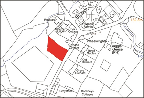
This is a relatively large field that, with the development opposite, forms the southern entrance to the main village of Buckland Newton.
The field slopes up to the west, and development is not proposed on the higher ground where it would be much more prominent in the local landscape. The removal of the concrete shed base in the north-west corner would provide an additional planning benefit and should be secured either through planning conditions or a suitable legal agreement.
Although the southern part previously has contained a pond, this was as a result of a relatively recent works and has silted up because of the sediment from surface water flows across the site. The continuing presence of water in this area has meant that there is a variety of wetland plants and thus it is desirable that this wetland area should be retained. These support a variety of insect life including butterflies and dragonflies, and provide good feeding areas for bats and birds and common reptiles such as slow worm and grass snakes. With appropriate management this habitat can be retained, providing biodiversity benefits, and this should be secured through planning conditions.
Development will therefore be limited to the north-eastern part of the site, which is the area closest to the village. The development of this area also offers an opportunity to create a small number of parking spaces to provide additional off-road customer parking for the shop, supporting this important community asset. This should be secured as part of the planning process and may need to be transferred to a suitable body (such as the Parish Council) to ensure its on-going management. Development on this site must include measures to improve visibility at the access/egress for highway safety purposes, and also include flood mitigation measures.
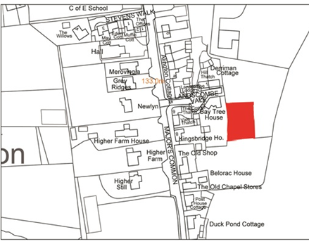
Site 1: Field south of ‘Higher Still’, west of B3143
© Crown copyright and database right (2015). Ordnance Survey Licence No. 100051694
Site 1: Field south of ‘Higher Still’, west of B3143
This field is to the rear of the three pairs of semis that form Major’s Common, and west of Freshfields, in the central part of the village. The field has been used most recently for grazing, and slopes gently up towards to eastern boundary. The site is relatively large (just over 0.2ha or 0.5acres), and could comfortably accommodate two pairs of semi-detached homes. Care needs to be taken to avoid creating an inappropriate ‘estate’ feel in terms of the design and layout of this site. The landowner has indicated that all the homes should be affordable to local people.
There is a mature oak on the eastern boundary, and the layout should avoid any impact on this locally important tree. Although not recorded there may be surface water flows across the site that will need to be taken into account.
Vehicular access would be possible directly from Castle Lane, and there would be an opportunity to improve pedestrian connections between Landscombe Vale, Major’s Common and Castle Lane by providing a connecting footpath through the site (subject to negotiation with the adjoining landowners). This would provide alternative safer routes through the village.
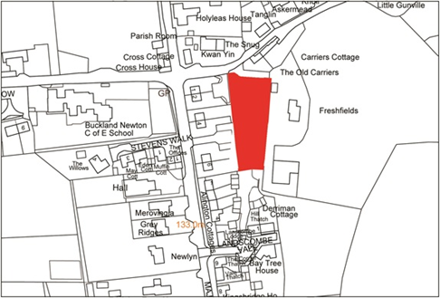
Site 2: Field to rear of 1 – 6 Majors Common on B3143
© Crown copyright and database right (2015). Ordnance Survey Licence No. 100051694
Site 2: Field to rear of 1 – 6 Majors Common on B3143
The field adjoining and accessed through Landscombe Vale provides a limited opportunity for housing. However it is well located in terms of its proximity to the main centre of the village including the school and playing fields.
The sloping nature of the site and adjoining built-up areas create issues for development in this location, particularly in relation to surface water run-off and overlooking of adjoining properties to the west. As such there is only very limited potential for development of one or two homes, restricted to the south-western corner of this site. It does, however, provide an opportunity to reduce the surface water run-off and actually improve this situation for properties along the main road, and it is on this basis that the site has been included in the neighbourhood plan. The scale and layout will need very careful design, and should be of limited height (ie single storey bungalows).
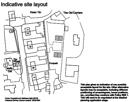
Site 3: Field to the east of Landscombe Vale
© Crown copyright and database right (2015). Ordnance Survey Licence No. 100051694
Site 3: Field to the east of Landscombe Vale
Policy RES1:
The combined sites will provide and up to 11 new homes in total, with an appropriate mix of open market housing and affordable housing in accordance with Policies H1 – H3.
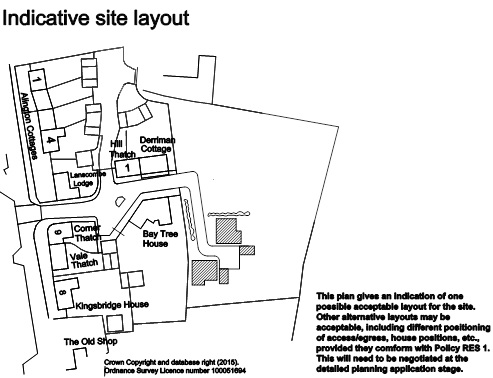
(a) Field south of ‘Higher Still’, west of B3143
The built development will be limited to the north-eastern part of the site. The concrete shed base in the north-west will be removed and the area landscaped appropriately, and the area of the site to the south managed for wildlife, flood risk and surface water management.
The scale of development should take into account the sloping nature of the site, and limited to 1 to 1½ storey homes. The housing should be set back a reasonable distance to avoid overlooking of the homes opposite. A suitable configuration would be for 2 pairs of 1½ storey semi-detached houses and a bungalow.
In addition to residents parking, provision for at least 6 parking spaces will also be made available and reserved for visitors to the local shop during normal opening hours.
(b)Field to rear of 1-6 Majors Common on B3143
The built development should avoid any impact on the mature oak along the eastern boundary of the site, and make provision for a footpath link to be created from Castle Lane to the B3143 (through Major’s Common) and Landscombe Vale. The housing should be located and orientated to avoid overlooking the private amenity space of adjoining homes. A suitable configuration would be for two pairs of facing semi-detached houses broadly opposite the Major Common access point.
(c) Field to the east of Landscombe Vale
The development of the site for up to two modest two bedroom single storey homes should include measures to prevent any contribution to the flooding problems previously experienced by nearby properties, by limiting the surface water run-off from the site. The design and layout of the development should ensure nearby properties and private garden areas are not adversely overlooked.
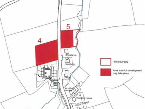
The area to the field boundary north of Lydden Meadow and Brooklands is about 1.2ha (3acres) in size. A site of this size in a more urban area would potentially accommodate a significant amount of development. However given the peripheral and rural nature of the site a much more modest amount of development is proposed. The site should provide sufficient land for in the region of 10 new homes, comprising six affordable homes of varying size (according to need) which would be most appropriately developed on the land to the west of the B3143, and up to four open market homes (of a size no more than 3 bedrooms) which would be more suited to the land to the east side of the B3143. It may be possible to phase the development dependent on need and viability, provided that the delivery of the affordable homes is secured.
The land north of Lydden Meadow should not seek to replicate the courtyard style of that development, but would be more suitably designed with a mix of linear development facing road (given the prevailing character), with some properties to the rear to make efficient use of the site. Access to B3143 should be towards southern end of site, which will help provide a landscaped gap between the existing development at Lydden Meadow and the new homes.
The land north of Brooklands would lend itself to frontage development, particularly given the proximity to the river (that flows along the eastern edge) which provides a richer wildlife habitat and is occasionally prone to flooding.
The proposed development would retain a gap between the village of Buckland Newton and Duntish to the north, which should retain its separate identity.
The site would require mains water extension, the costs of which will need to be borne by the development.
Site 4: Land to north of Lydden Meadow, west of B3143, and
Site 5: Land north of Brooklands, east of B3143
© Crown copyright and database right (2015). Ordnance Survey Licence No. 100051694
Policy RES2: Land north of Lydden Meadow and Brooklands, on either side of the B3143
The combined sites will provide up to 10 new homes, with an appropriate mix of open market housing and affordable housing in accordance with Policies H1 – H3.
(a) Land to north of Lydden Meadow, west of B3143
Development of the site west of the B3143 should provide six new homes and include frontage development facing onto the road. The design approach should emphasise that the traveller is entering / exiting the village at this gateway location. There should be a landscaped gap between the new development and Lydden Meadow, which may also provide the main point of access to the site.
(b) Land north of Brooklands, east of B3143
Development of the site east of the B3143 should provide up to four new homes and comprise frontage development facing onto and close to the road. A suitable landscape buffer should be maintained alongside the river for wildlife benefit.
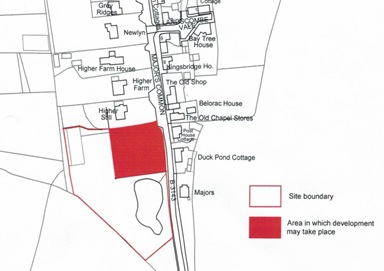
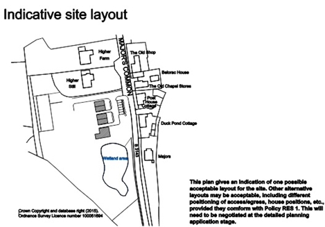
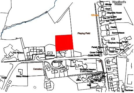
This is a relatively flat site of approximately 0.4ha (1 acre) behind the existing development along the lane and adjoining the parish field to the east. It is close to the school and the core of the village. The site should provide sufficient land for in the region of six new two and three bedroom homes, of which at least half should be affordable homes.
There are few planning constraints relevant to the site. Planning consent (WD/D/15/000376) has been granted for the demolition of the former dairy buildings adjoining the road and their replacement with four new dwellings (being within the defined development boundary) and includes a suitable access point that can be used to serve this site. The site provides the potential for a positive built frontage overlooking the public open spaces (the play area, parish field and potential new tennis court/all weather pitch.
Site 6: Field north of Brookfield, west of Parish Field
© Crown copyright and database right (2015). Ordnance Survey Licence No. 100051694
Policy RES3: Field north of Brookfield, west of Parish Field
The site will provide up to 6 homes in total, comprising a mix of 2 and 3 bedroom properties, with an appropriate mix of open market housing and affordable housing in accordance with Policies H1 – H3. A comprehensive planning approach should be taken with the proposed development of an all-weather sports pitch to the north of the site, including landscaping, access and car parking. The site layout, orientation and design of the housing should provide a positive frontage and surveillance across the existing and proposed playing fields to the east and north.
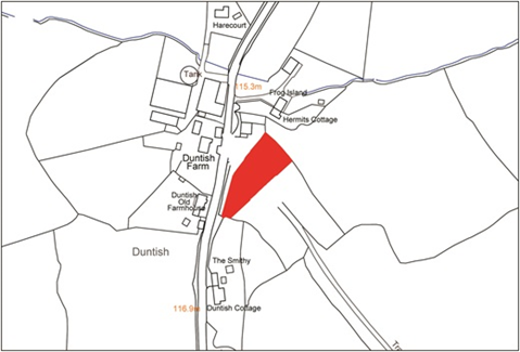
Land either side of the farm track opposite Duntish Farm provides an opportunity for limited new development in this location, away from the main village of Buckland Newton. The site has potential for up to four modest homes, for up to 100% affordable housing, and in any event as a rural exception site at least two should be affordable. Pairs of semi-detached cottages facing towards the road would be in keeping with local character.
Site 7: Land opposite Duntish Farm, east of B3143
© Crown copyright and database right (2015). Ordnance Survey Licence No. 100051694
The field to the south has been less intensively used and therefore at the current time provides a richer wildlife habitat. The layout of the site will therefore need to take this into account, and may limit the extent of development.
A detailed Flood Risk Assessment has been carried out, concluding the risk of flooding from overland flow is negligible. The detailed development proposals will include a surface water drainage design which will ensure existing flow rates from the site are maintained or improved upon, so that there will be no off site impacts relating to flood risk as a result of the development.
The site would require mains water extension, the costs of which will need to be borne by the development.
Policy RES4: Land opposite Duntish Farm, east of B3143
The site is identified as a rural exception site to provide up to 4 homes in total, of which at least half should be affordable to local people. They should reflect the character of modest farmworker dwellings. A suitable configuration would be for two pairs of semi-detached cottages facing onto the road front.
The layout of the development should take into account the potential biodiversity interest of the site and appropriate surface water management.
A number of sites deemed suitable for new housing are not of sufficient size or in an appropriate location to be treated as a rural exception site for affordable homes and open market homes as a matter of policy. However, the local plan strategy requires that all new open market housing sites make a contribution to secure affordable homes to meet local needs (through providing new affordable homes or, where this is not possible, making a financial contribution), so the landowner will either need to provide them as affordable housing, or to contribute towards the provision of more affordable housing on an alternative site.
| Site | Location | Total homes |
| 8 | Land at Knap Farm, off Lockett’s Lane | 2 + 1 affordable |
| 9 | Land adjacent to Lydden Cottage | 1 |
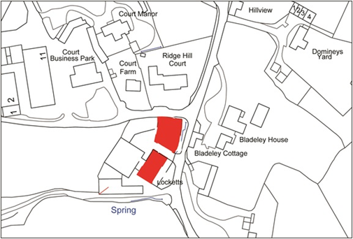
There is potential for the conversion or replacement of the existing farm building on this site to provide some limited housing in this location.
Under the adopted local plan policy SUS3 it would be possible for the existing farm buildings to be converted to affordable homes, rural worker’s dwellings or to new homes and rented (either for residential or holiday use, and provided they were not sold off but remained tied to the wider holding / main property).
The northern part of the site also provides a potential area for further built development. The site as a whole has the potential to accommodate up to 3 new dwellings, of which one at least one should be an affordable home for local needs.
A detailed Flood Risk Assessment has confirmed that there is negligible risk of localized flooding from surface water run-off from the nearby fields, and no flood risk management measures are required. Potential drainage improvements by the land owner could significantly reduce the risk of surface water flooding to neighbouring properties should the development go ahead.
Site 8: Land at Knap Farm, off Lockett’s Lane
© Crown copyright and database right (2015). Ordnance Survey Licence No. 100051694
Policy HS1: Land at Knap Farm, off Lockett’s Lane
The site can be developed for up to 3 homes in total. Conversion of the existing farm building should provide one home, and the northern part of the site can accommodate one pair of semi-detached homes.
The scale and design of the new buildings should be no more than 1½ storeys in height, and should face west to avoid overlooking. The existing hedge to the east should be maintained and new infill hedge planted along the northern boundary.
Given the prevailing risk at this location, flood risk and surface water management should be carefully considered.
This site forms part of the current garden area of Lydden Cottage, and is relatively unconstrained. The development of a cottage (ie one and a half storeys) of up to 3 bedrooms in size would be in keeping with local character in this location, continuing the building line along Lockett’s Lane. However, given the topography with a bank at the road frontage and the site then sloping down and away from this, the ground level should be reduced to nearer the road level to prevent the new home appearing ‘perched’.
Site 9: Land adjacent to Lydden Cottage, Lockett’s Lane
© Crown copyright and database right (2015). Ordnance Survey Licence No. 100051694
Policy HS2: Land adjacent to Lydden Cottage, Lockett’s Lane
The development of the site for a one and a half storey dwelling of up to three bedrooms, fronting onto the lane, will be permitted, provided all other Neighbourhood Plan policies regarding size, design, etc. are met. Any new development should safeguard the setting of the Conservation Area.
1Gross internal floor area is the internal area of the building, and include rooms, circulation and service space such as stairs and corridors, toilets, storage etc.
2Technical housing standards - nationally described space standard, published March 2015 by Department for Communities and Local Government https://www.gov.uk/government/uploads/system/uploads/attachment_data/file/421515/150324_-_Nationally_Described_Space_Standard____Final_Web_version.pdf
< Previous | ^ Top | Next >