
Bridport and the surrounding parishes have a rich and diverse heritage recognised in over 500 Listed Buildings and 7 Conservation Areas.
In addition to the designated heritage assets the neighbourhood plan area includes many locally valued buildings, structures and features that contribute to the character and distinctiveness of the area.
This section sets out policies to safeguard designated and non designated heritage assets
Within the neighbourhood plan area the historic building legacy is concentrated within defined Conservation Areas although many important building and features are spread throughout the area.
Conservation Area Appraisals produced by West Dorset District Council describe in detail the characteristics of each area and show the listed buildings and other important buildings, hedgerows, trees and gateways. Outside the Conservation Areas there are numerous Listed Buildings and Locally Valued Non Designated Heritage Assets which, whilst being unlisted, are considered to contribute significantly to the heritage of the neighbourhood.
The appraisal reports also refer to factors that pose some threat to the Conservation Areas. These include loss of green space through infill housing, loss of architectural detail during maintenance, the difficulty sourcing original materials, buildings falling into disrepair and street clutter due to poles and wires.
Adopted Conservation Area Appraisals are used as supplementary planning guidance and support the conservation area policy within the adopted Local Plan for West Dorset, Weymouth and Portland (2015).
MAP 6 CONSERVATION AREAS
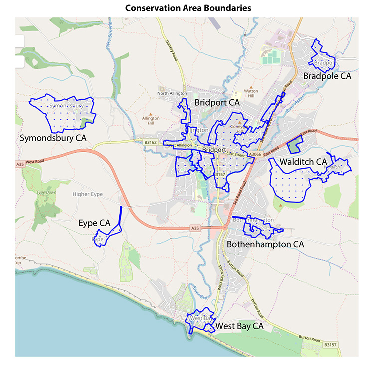
There are seven Conservation Areas (CA) within the neighbourhood plan area. The boundaries of each area are shown on Map 6. The areas are described in the following documents:
The historic building legacy and its characteristics for the parishes within the neighbourhood plan area are described in great detail in the Conservation Area Appraisals produced by West Dorset District Council. These adopted Conservation Area Appraisals are used as supplementary planning guidance. They support the conservation area policy within the adopted Local Plan for West Dorset, Weymouth and Portland (2015). Any development within one of the Conservation Areas will be assessed for suitability against the established criteria for that area.
The appraisal reports also refer to factors which pose a threat to the character of the Conservation Areas, these include loss of green space through infill housing, loss of architectural detail during maintenance, the difficulty sourcing original materials, buildings falling into disrepair and street clutter due to poles and wires.
It is impossible to list here all of the many hundred Listed Buildings (LBs) within the neighbourhood plan area. Those wishing to explore the list further can do so using the National Heritage List for England, which is maintained by statutory body, Historic England: https://historicengland.org.uk/listing/the-list/
There is one Registered Park and Garden, much of which coincides with the Millennium Green on Coneygar Hill. The entry says that Downe Hall in Bridport was registered as a Grade II garden in 1996. It is described as: “Compact pleasure grounds and park laid out in the late 18th century to accompany a new house, together with early 20th century formal gardens designed by E S Prior”.
There are 3 Scheduled Monuments within the neighbourhood plan area;
It is widely accepted in the literature and appraisal documentation that the archaeological potential of the Bridport area has not been realised. Digs have been restricted to specific plots, largely as and when site developments have taken place. The pre-medieval record is therefore limited, despite known Saxon activity and some Roman finds.
See BANP evidence base: https://www.bridport-tc.gov.uk/bridport-area-neighbourhood-plan-evidence/
The Bridport Area Neighbourhood Plan focuses on policies for the non designated heritage assets found across the neighbourhood plan area. Designated heritage assets are afforded protection in both national and local plan policies:
Designated heritage assets are also protected under legislation, including the Planning (Listed Buildings and Conservation Areas) Act 1990. Many non-designated heritage assets are described in conservation area appraisals.
Policy HT1 identifies buildings, structures and features as being worthy of protection as non-designated heritage assets, which are locally valued due to the important contribution that they make to the distinctive local character of the neighbourhood plan area. ‘Important local buildings’ and ‘building groups’ identified in the relevant conservation area appraisals are also considered to be non-designated heritage assets for the purposes of applying national and local plan policies that protect heritage assets.
The Joint Councils Committee has drawn together and will maintain a local list of buildings, structures and features identified as being worthy of protection as non-designated heritage assets. This locally kept list may be updated from time to time as additional assets are identified
Most of the buildings and structures included in the local list have been cited as buildings of local interest and distinction in a range of documents, including; Conservation Area appraisals, parish plans, Bridport Townscape Appraisal (2000) and Dorset County Councils Historic Towns Report – Bridport (2008).
This policy does not confer listed building status (a national designation) on any non-designated heritage assets, and works to buildings and structures on the local list will not necessarily require listed building consent.
Policy HT1 Non Designated Heritage Assets
The Joint Councils Committee has prepared (and will maintain) a list of buildings, features and structures in the neighbourhood plan area which are considered to be ‘non-designated heritage assets’ and should be treated as such for the purpose of applying national and Local Plan policies including Policy ENV4 of the Adopted Local Plan (2015).
The list of non-designated heritage assets available at:
https://www.bridport-tc.gov.uk/bridport-area-neighbourhood-plan-evidence/The pride which Bridport area residents feel in their town is well-placed and is borne out by the town having been highlighted as one of the best places to live by The Sunday Times (18 March 2018).
The Conservation Area Appraisals across the neighbourhood plan area highlight the importance of the historic character of settlements and in particular the value of well designed shopfronts to the sense of place and vitality of the area’s retail offer. Community consultation reinforces the importance of the public realm and the support for safeguarding the unique spirit of Bridport and surrounding parishes.
The public realm, the streets, squares, and spaces between the buildings, is an essential asset of community life in the Bridport area. These spaces are where social life is played out and form the backdrop for the vitality and cheerfulness of street life in the town in particular. Strong pedestrian, cycle and public transport connections are vital factors to ensure successful public realm design and these are covered in the Access and Movement section.
The cumulative impact of developments that use inappropriate materials and intrusive lighting can erode the historic integrity of neighbourhood plan settlements. Therefore, the plan contains a range of polices that address design matters such as these.
The preferred policy response is to conserve and enhance the rich built heritage of the neighbourhood plan area.
Policy HT2 Public Realm
Proposals that have a negative impact or “harm” the qualities of the public realm as identified in the Neighbourhood Characteristics of this plan will not be supported.
To protect the attractive characteristics of areas main shopping areas it is necessary to conserve the vitality and interest of the historic street scene. This is achieved by protecting the collective and individual qualities of shopfronts, whilst recognising modern retail needs. This neighbourhood plan considers that these two demands are compatible. Using sensitive design and careful attention to detail, a shop can promote its image through its unique quality.
Appendix 1 provides detailed shopfront design guidance for the neighbourhood plan area. By describing the character of the retail heritage of the neighbourhood plan area the intention is to provide businesses, retailers, landowners and developers with the starting point for developments that will respect and add to the special character of the plan area.
Policy HT3 Shopfront Design
The setting of Bridport and the surrounding parishes within the neighbourhood plan area, and their distinct identities can be found in the green corridors that not only connect local residential settlements but contain a wide range of wildlife. These corridors allow residents to walk from villages into Bridport along a network of footpaths.
The neighbourhood plan area is dominated by several hills. They are flat-topped with steep sides and can be seen all over the neighbourhood area, greatly adding to the distinct “sense of place”.
The special landscape assets have inherent value in terms of natural beauty, but also have economic value in terms of tourism and attracting people to the area.
The whole neighbourhood plan area is washed over by the Dorset Area of Outstanding Natural Beauty (AONB) designation. In line with NPPF 2019 paragraph 172 all development in the neighbourhood plan area needs to give ”great weight should be given to conserving and enhancing landscape and scenic beauty in National Parks, the Broads and Areas of Outstanding Natural Beauty, which have the highest status of protection in relation to these issues”.
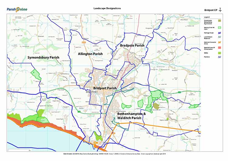
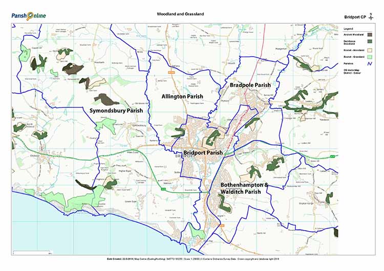
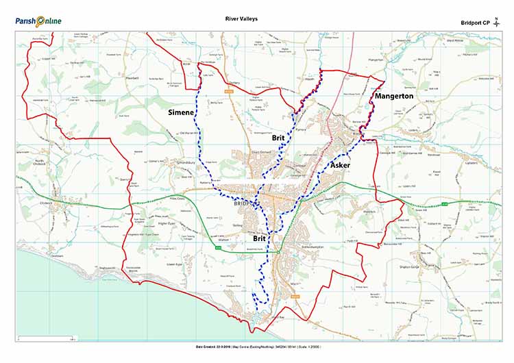
A number of assessments and management plans describe the special landscape qualities found in the neighbourhood plan area and can be used to safeguard landscape character by informing and guiding development proposals. These include:
The neighbourhood plan wishes to support that assessment through its own set of landscape policies. Local distinctiveness and a sensitive response to local character go beyond aesthetic considerations, and cover issues such as landscape, surrounding hills, footpaths, skylines, townscape settings as well as green corridors.
Policy L1 Green Corridors, Footpaths, Surrounding Hills & Skylines 1.
It is important for developers to take account of the need to plan for biodiversity to be able to thrive at both local and much larger landscape scale, through the appropriate protection of key sites, priority habitats and species, and the strengthening of local ecological networks.
Maps 7,8,9 Designated Areas, Woodlands (revised) & Grassland and River Corridors Maps
The term “green corridors” refer to the network of spaces and linkages by footpaths that are valued for their wildlife and pedestrian connections with the wider neighbourhood area. As such, the green infrastructure network will be given significant protection from development. It is recognised by the community that the active management and enhancement of these features is encouraged as part of safeguarding their future. This support will continue to contribute to a successful local economy through making the area an attractive place to live, work and visit.
Policy L2 Biodiversity
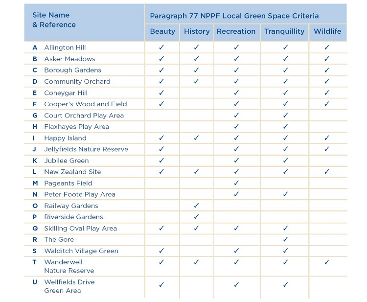
The National Planning Policy Framework introduces Local Green Space designation to provide special protection against development for green areas of importance to communities.
The designation can be used where the:
The designation of land as Local Green Space through the neighbourhood plan allows communities to identify and protect green areas of particular importance to them. In developing the list of sites to be designated Local Green Space were assessed using the following criteria:
( see Table 1 - Local Green Spaces –reasons for designation )
A full explanation of the methodology, evidence and justification to support the designation of the nominated Local Green Spaces can be found in the neighbourhood plan evidence base: https://www.bridport-tc.gov.uk/projects/bridport-area-neighbourhood-plan-evidence/
Policy L3 Local Green Spaces
MAP 10 Local Green Spaces Designated in the Neighbourhood Plan Area
(revised)
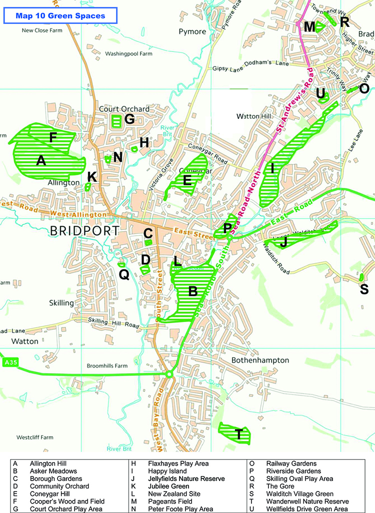
Table 1 – Local Green Spaces (Criteria for Designation)
Map 11 – Green Gaps: Anti Coalescence Areas
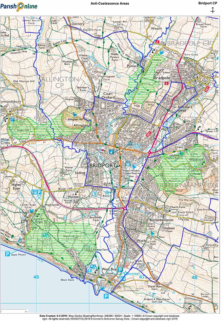
The town of Bridport and the surrounding parishes of Allington, Bradpole,
Bothenhampton, Walditch and Symondsbury, are characterised by their distinctive landscape and topology. They provide not only unique backdrops to their settlements but identify the relationship between the town and its outlying parishes and their surrounding largely undeveloped landscape.
All of this is vitally important in retaining not only their individual rural or urban character, but an important sense of place too. Whilst it is accepted that settlements will grow, there is a risk that as development happens, the town and surrounding parishes will coalesce. This will happen, if for example, development were to take the form of ribbon development alongside the surrounding road networks that
link the town and the parishes concerned.
In certain locations, it would take only a small amount of development in the green gaps as indicated on the Map 11 provided, for this to happen. Such development would not only undermine the sense of place that now exists in the town and parishes concerned but undermine the distinctiveness of individual communities both in terms of the visual, social, and physical separation that now exists. It would also lead to urban sprawl and encroachment into the Dorset Area of Outstanding Natural Beauty. These points are recognised in several existing parish plans and village design statements. These include recognising that their sense of place is retained in that residents pay considerable regard to the natural setting of the parish and town.
Policy L4 Green Gaps: (Anti-Coalescence Measures)
Community consultation has demonstrated a strong desire to add to and strengthen the existing network of green spaces in the neighbourhood plan area. Additional green spaces and stronger connections are required, especially as linkages between the surrounding hills, the river corridors through to the centre of Bridport and the housing estates.
The range and quality of the ecosystem services provided by green spaces, in particular; flood alleviation, wildlife habitats and access to health and wellbeing benefits need to be recognised and actively managed.
The policy response of this neighbourhood plan is to support the extension and active management of green infrastructure across the neighbourhood plan area.
Policy L5 – Enhancement of the Environment
Appropriate to the scale of development, proposals for new housing development should:Bridport is the town at the heart of the
neighbourhood area and its success is of critical importance to the prosperity of the surrounding area.
This has been the case since medieval times and continues to be so. The Centre of Bridport provides employment for many as well as offering a rich mix of cultural and retail activities. Bridport is renowned for its twice-weekly street market, independent shops, cafés, pubs, and arts and music-based events. Bucky Doo square lies at
the heart of the town and hosts regular events.
The centre of Bridport is enjoyed by locals and visitors alike and safeguarding Bridport’s unique character and vitality is therefore paramount and a key aim of this neighbourhood plan.
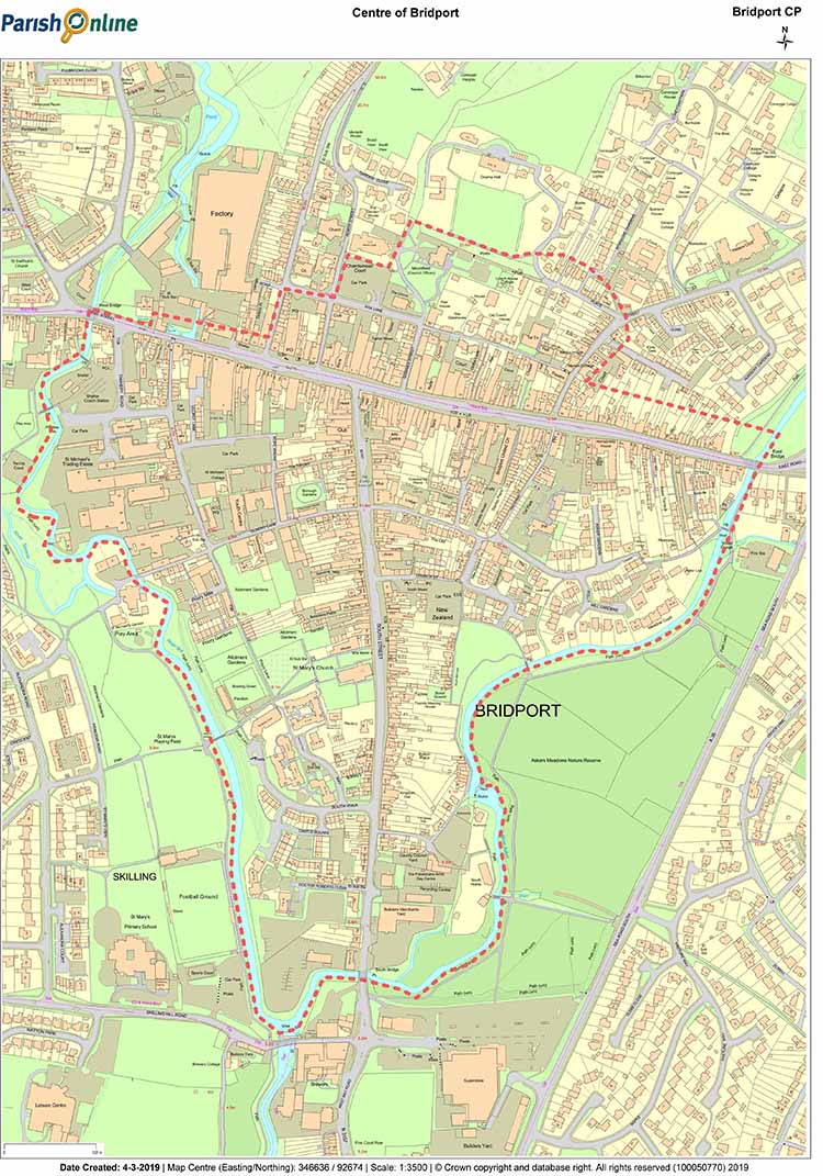
MAP 12: Area Defined as Centre of Bridport (unchanged)
Bridport is an attractive and historic market town. The Centre of Bridport contains many fine buildings of historic importance, a good number linked to the rope and net industries and covered by Listed Building or Conservation Area policies. The continuity and integrity of the townscape provides a valuable backdrop for commercial activity and underpins the appeal of Bridport as a place to live and work.
The Neighbourhood Plan Consultation Report, Neighbourhood Plan Shop Survey and Bridport Conservation Area Appraisal (2010, which includes multiple references to shop fronts and their contribution to the town centre) as well as West Dorset District Councils retail survey and the neighbourhood plan retail floorspace survey (2018) evidence the need to reinforce the role of the Centre of Bridport and its potential to support a more sustainable pattern of development by ensuring that it is the focus for a range of private and public services to which people need access.
The collected evidence for this neighbourhood plan shows that Bridport town centre is vibrant and faring well. It compares well with other similar sized market towns in the south west. It appears to have built a distinctive offer based upon a good range of shops, many of which are independents. By bucking the national trend of declining choices and domination of chain stores Bridport appears to have carved out a successful and distinct niche.
The planning policies contained in this neighbourhood plan seek to ensure that retail and other key uses located in the Centre of Bridport are maintained and that new development make a positive contribution to the character, vitality and viability of the centre of Bridport as well as the wider neighbourhood plan area.
Bridport, as a thriving 21st Century market town, can help regenerate the surrounding area by being a:
Policy CoB1 Development in the Centre of Bridport
Development in the Centre of Bridport (See Map 12) which meets the following design and planning principles will be supported, subject to satisfying other policies in the Plan, where it:
Policy CoB2 Ropewalks Car Park & Bus Station Car Park
The character and vitality of the Centre of Bridport owes a lot to the locally-owned and largely independent businesses that bring financial benefit and security to those living and working in the area.
Ever-changing consumer shopping preferences are causing uncertainty for the future viability of small-scale, retail activity in Bridport. The move to internet-based shopping is having wide ranging impacts on high streets across the country, driving shop closures and reducing the range of the retail offer.
The preferred policy response is to develop policies and projects (including more detailed surveys) that can help underpin the diversity and vitality of the small, independent businesses currently operating in the town centre and to resist developments that undermine this.
| Bridport Retail Floorspace Survey 2018 using data from the District Valuation Office | ||
| Street | Ave Retail floorspace of units (sq m) | % below 280 sq m ( defined as small) |
| South Street | 66.51 | 97% |
| West Street | 147.51 | 90% |
| East Street | 160.46 | 86% |
Evidence shows that some 91% of retail units in Bridport Town Centre fall below the government’s definition of small (<280 sq m). It is therefore considered reasonable, in supporting the small, independent retail offer in the town, to place a requirement on retail unit development to retain a high proportion of small units.
Map 13 : Bridport Town Centre defined by Local Plan (2015)

Policy CoB3 Small Business Support
This important area of Bridport was formerly the heart of the rope-making industry. It has evolved into a quirky, iconic mix of artist workshops, start-up businesses, vintage, and antique shops. Conserving the historic character of St Michael’s whilst retaining the unique blend of artisan activity and entrepreneurial spaces will be vital to help promote Bridport’s distinct sense of place.
The owners of the St Michael’s Estate have obtained outline planning permission for
92 homes and new commercial space (7,951 sq m). It will be essential that the current tenants and community interests in St Michael’s work with the landowners to deliver a redevelopment that is in keeping with current uses and values of the area. The redevelopment of St Michael’s offers the opportunity to address the access and amenity issues along the River Brit, helping to rediscover the green corridor along the river whilst implementing pedestrian and cyclist connections between Foundry Lane and the bus station.
The preferred policy response is to conserve and enhance the character of the St Michael’s Estate, in particular the historic listed and unlisted buildings, whilst ensuring that the current range of arts and artisan activities can continue to maintain the special character of the area and shopping experience. There is also a need to ensure continued access to employment opportunities in this part of the centre of Bridport.
Policy CoB4 St Michael’s Support for the Creative Industries
In the provision of new commercial floorspace at the St Michael’s Estate, proposals will be supported which seek to retain a broadly comparable area (7,951m2) of workspace for small and start up businesses and particularly for those in the creative industries.
To provide welcoming, attractive and sustainable communities, housing developments must be well designed and built. New development across the neighbourhood area will be expected to have high standards of design.
Housing proposals should also demonstrate how its new homes meet the needs of an ageing population and those with impaired mobility.
To meet these objectives the local authority’s Supplementary Planning Document “Design and Sustainable Development Planning Guidelines” provides a useful reference point and much of it is adopted here.
This section addresses the Bridport Area Neighbourhood Plan objective number 7 ‘To ensure that the design of housing developments and the homes within them are responsive to local context and conditions, are energy efficient, adaptable to different residents’ abilities, and accessible to public services’. High standards of design are encouraged and these design guidelines and policies give greater clarity with respect to design expectations for housing developments and will be a material consideration in deciding planning applications.
Good design ensures attractive, usable, durable and adaptable places to live, contributes to sustainable development, and should be applied whatever the type or scale of building works proposed. A well designed development should be in keeping and in scale with its location, and sensitive to the character of its surroundings. The three main references from which policies have been developed are:
Key aspects of each are outlined below. It is also noted that planning applications must adhere to a number of Local Authority requirements as set out in their Validation Checklist2.
All development within the neighbourhood plan area should deliver the highest possible standards of design, both in terms of urban form and sustainability criteria. In 2009 West Dorset District Council adopted a Supplementary Planning Document called ‘Design and Sustainable Development Planning Guidelines’. This extensive document provides clarity on how a housing development might meet planning requirements and is a material consideration in deciding planning applications. It provides 10 design policies and explains how these policies are applied in relation to different types and scales of development. The key aspects relevant to the neighbourhood plan area have been extracted and incorporated below. This neighbourhood plan provides 10 design policy themes as listed below.
The first 9 are derived from the 2009 ‘Design and Sustainable Development Planning Guidelines’.
Policy themes 1 and 2 relate to good planning practice, the need to understand the site and the issues that may be raised in relation to any development, and are relevant for all types and scales of development.
Policy themes 3 and 4 relate mostly to large-scale developments or changes that will affect how a neighbourhood functions.
Policy themes 5 to 7 consider how buildings affect surrounding spaces, and how those spaces can function most effectively.
Policy themes 8 to 10 focus on the more detailed design and sustainability of built development, and are most relevant to householders considering changes to their properties as well as being applicable at larger scales.
Understanding the development site and how it relates to the wider area is essential to ensuring that developments can reinforce a sense of local identity within the neighbourhood plan area, have good access to the town (for those developments closer to Bridport town centre), and do not adversely impact neighbouring uses.
Checks on, and surveys of, the setting of the development to identify features of interest for possible incorporation into the design should be made at an early stage.
A site assessment should be submitted with most planning applications (as part of the design and access statement) that identify the various constraints and opportunities for that site, and how these have influenced the design. This may include information on:
Policy D1: Harmonising with the Site
Involving the right people at an early design stage will save unnecessary time being spent pursuing schemes that have insurmountable objections, and may potentially achieve a greater degree of support for a project. It may also show opportunities to improve a scheme.
Developers should engage in early discussions with adjoining residents, service providers and other groups likely to be affected by, comment on, or have creative ideas about the development, to ensure the design takes into account planning issues, problems and opportunities that these groups may identify.
Who is consulted and how will depend upon the type and scale of the development and developers should identify all stakeholders and potentially impacted parties as the first step in establishing a consultation programme.
In addition to the requirements of the local validation list, it is good practice for a statement setting out who was consulted, the findings and how these have influenced the design to be submitted for developments appropriate to the scale of that development.
Policy D2: Programme of Consultation
Applicants are encouraged to enter into a meaningful programme of community consultation appropriate to the scale of development.
Aspects of developments that promote lifestyles that are not reliant on the car, and provide natural opportunities for healthy recreation and social interaction will be supported.
Developments should ensure:
The road and pavement widths should reflect the likely levels of vehicular and pedestrian traffic, providing this doesn’t undermine the historical significance of the route.
Design should ensure that less able people have reasonable access to facilities (including for the passage of wheelchairs and mobility scooters), services and premises, and pavements and road crossings designed accordingly.
Designs should consider first pedestrians (including wheelchairs and mobility scooters), then cyclists, public transport users, specialist service vehicles (emergency, waste) and other motor traffic, in that order.
Policy D3: Internal transport links
Proposed new residential development should incorporate the following:
Planning of large developments should aim to ensure that places people go to often (such as local shops, school and doctor's surgery) are in a reasonable walking distance of their homes. A mix of open spaces can also support a greater mix of plants and wildlife and provide recreational and other benefits.
For developments in the neighbourhood plan area the proximity of, and potential impact on, existing facilities will be the main consideration. The following factors are also relevant:
In planning developments of 100 or more homes a detailed development brief or masterplan for the site would enable demonstration that these and other requirements are addressed.
Policy D4: Mix of uses
Making efficient use of land means providing an appropriate mix of uses at an
appropriate density, whilst also taking account of an area’s prevailing character and creating attractive places with acceptable living standards in terms of amenity.
In terms of housing density, an element of land-use efficiency, a target of 40 dwellings per hectare is typical. The setting of a minimum density is no longer an element of the National Planning Policy Framework but, given the demand for housing and affordable housing, low density developments should be avoided unless justified on the basis of, for example, local character impact or poor accessibility of a location.
The subdivision of plots may be inefficient if it results in areas that are difficult to develop, for example because of proximity to adjoining buildings or other limitations, and when the leftover space has no intrinsic value.
The adoption of landscape solutions, for example inclusion of street trees, verges, and planting strips, to help soften the impact of a new development will be supported.
The design and intended use of the space between buildings, on- street parking, pavements, public open spaces and private front garden, will also have a bearing on local character, overlooking and privacy, and the servicing arrangements for the building. Public spaces must work within the development's overall design to help achieve the most efficient use of land.
The use of brownfield sites and vacant housing (including unoccupied accommodation above shops) suitable for occupation is, in itself, an efficient use of land and is supported provided the land is not of high environmental value.
Policy D5: Efficient use of land
Development should make efficient use of land, and layouts that create wasted or leftover land will not be supported.
In built-up areas, the relationship between the buildings is a major factor in defining the character of the street, and is also important in reducing fear of crime.
A common building line is normally the preferred approach to creating well-defined streets. Street trees and boundary features can also help define a street or space. Variations in the building line will be acceptable, where they provide interest and local character.
The road and pavement widths should reflect the road's place in the hierarchy within an overall network.
Factors that should be addressed in the design are:
Information on the above criteria should be incorporated into the design and access statement.
Policy D6: Definition of streets and spaces
Proposals for new residential development in the plan area should create a sense of place through:
It is important that public areas are well used, appropriately lit and overlooked, to reduce opportunities for crime.
Extensive sections of blank walls or fencing facing onto public areas will not normally be acceptable. Windows and doors (including the main access door) should face onto the street and other places where surveillance is needed (such as parking courtyards).
The required privacy for ground floor rooms on busy streets should be maintained and can be achieved by raising the floor above street level or providing a private front garden area.
Designs should ensure that areas that do not need to be overlooked, such as rear gardens, are clearly defined. Designs should avoid creating easy, unobserved rear or side entry points for intruders.
Policy D7: Creation of secure areas
It is important that new developments are seen as part of, and belonging to, the location in which it is placed. Housing development design will be influenced by the neighbourhood plan area being within a designated Area of Outstanding Natural Beauty. Similarly developments within or encroaching on designated Conservation Areas will be required to conform to their existing surroundings. The description of Neighbourhood Characteristics chapter demonstrates the diversity of house design, invariably a reflection of the preferred style at the time of building.
Designs should ensure new development enhances local character, not merely duplicate existing developments which in themselves may not always be of good quality. Also it is recognised that local distinctiveness and innovation can go together in a way that supports the other objectives for good design.
Where there is a pattern of development (for example, relating to plot widths) that clearly defines the character of the street or reflects the history of the site, this should be respected, unless it would conflict with other objectives in which case a balance should be sought.
Development should not obscure important views and sight lines, or significantly reduce the impact of local landmark features.
Within the neighbourhood plan area there are a number of buildings greater than 2 storeys in height. Within certain developments heights of neighbouring building may dictate the appropriate height for a new or extended building. Similarly the provision of apartment blocks of, say, up to 4 storeys height would be appropriate as an integral part of a development.
However, where factors such as cutting out light from a neighbouring building or landscape and visual impact come in to play buildings should normally be no more than two storeys in height (with use of the roof space with dormer windows as a useable living space being accepted). Information on how the development has responded to local identity and addressed these considerations should be incorporated into the design and access statement.
Adoption of high quality architecture should result in attractive development in which the community feel a sense of ownership and pride. This can depend on factors such as:
The coherence or harmony with surrounding buildings and street scene. In an existing building, or an extension to it, the design and materials used should respect the character and appearance of the original building (this does not preclude incorporation of a modern yet complementary design).
Policy D8: Contributing to local character
Proposals for new development (residential and commercial) in the Plan area should demonstrate high quality architecture and seek to maintain and enhance local character as follows:
The lifecycle costs of the primary materials used in the construction of floors, roofs, walls etc should be considered. Use of the Green Guide3 to assess the environmental performance of the most common building materials is supported.
General energy and water saving approaches that are supported are:
Sustainable drainage systems are supported. Any large areas of hard surfacing (over 5 square metres) should normally be made permeable. Rainwater and grey water harvesting is a practical solution that can be accommodated in most new homes.
In terms of the design features of the dwelling itself, homes that meet the 16 Lifetimes Home4 criteria are encouraged. Developments that are easy to maintain and can be readily adapted to meet the needs of a range of potential users are encouraged.
The design of a home such that it is energy efficient is also covered under Climate Change policies.
Policy D9: Environmental performance ( see also Policies CC2, CC3)
Applicants are encouraged to design buildings to last, employing modern innovative technologies and methods of construction to, for instance, reduce construction costs, speed up construction, and minimise energy consumption and carbon emissions during the building’s lifetime, such as:
Light pollution causes annoyance to other property owners and disturbance to wildlife. Light spillage from external lighting can be minimised by careful siting, orientation and choice of external lighting installations.
The following policies apply to external lighting schemes (not all of which require planning consent).
Policy D10: Mitigation of Light Pollution
Proposals for external lighting schemes in any new development should seek to minimise light pollution by:
The Design Council’s Building for Life5 enables an objective assessment to be made by developers as to the extent to which 12 design quality aspects have been met.
Ideally the use of Building for Life should be implemented from the outset of the development process, including the involvement of the Local Authority (with communities able to be involved). To avoid fundamental disagreements at a later stage any issues should be highlighted early and resolved between the parties concerned.
Building for Life states It is applicable for developments of 25 to 50 homes per hectare.
The 12 aspects covered by Building for Life are summarised as:
Policy D11: Building for Life
Applicants for new housing developments are encouraged to assess their proposals against the 12 objectives in the guidance published in the latest edition of “Building for Life” published by the Design Council.
Proposals for large scale residential development should obtain the Building for Life quality mark and the achievement of nine “green” levels is encouraged.
Meeting the needs and aspirations of our ageing population concerns the entire machinery of housing delivery, from planning to construction. Emphasising the space of the home, HAPPI identified ten key design elements, the so-called HAPPI6 principles, these address:
Developments of any size intended to make provision for elderly person’s accommodation, such as housing for over 55s or sheltered housing will be expected to meet the HAPPI principles.
Policy D12: HAPPI (Housing our Ageing Population: Panel for Innovation) Principles
Proposals for new housing schemes which make provision for elderly persons’ accommodation, such as housing for over 55s or sheltered housing, are encouraged to demonstrate how they meet Housing our Ageing Population: Panel for Innovation (HAPPI) principles as part of the planning applications.
3 https://www.bre.co.uk/greenguide/calculator/page.jsp?id=2071
4 http://www.lifetimehomes.org.uk/pages/revised-design-criteria.html
5 https://www.designcouncil.org.uk/resources/guide/building-life-12-third-edition
< Previous | ^ Top | Next >