
5.1.1 The special character of Windsor’s public realm plays a vital role in Windsor’s success as a place in which to live and work, and as an appealing destination for visitors. Conserving a very high calibre of natural environment as part of that public realm is essential to our health and quality of life as well as to environmental sustainability, including climate change. Local people have identified a number of key aspects relating to the green infrastructure including open space and biodiversity that we can improve.
5.1.2 The fundamental importance of safe access to appropriate amounts of high-quality open space and areas of natural environment cannot be overestimated, and as shown through the COVID-19 pandemic, its wide-ranging benefits having been confirmed in both formal research and policy10.
OBJECTIVE Protect the environment and expand and enhance the green and blue infrastructure network and the safe access to it.
CONTEXT
5.2.1 The RBWM Open Space Audit 2008 has been used as evidence to develop the WNP policies, supplemented by the RBWM Open Space Study 2019. These list the open spaces under various typologies11 and make recommendations on quality, quantity, and accessibility standards, although the latter does not include spaces under 0.2 hectares in size.
5.2.2 The RBWM Open Space Study 2019 uses the Fields in Trust12 2015 (FIT) standards for Open Space for people living in towns and cities as well as the Thorpe Report on Allotments13 (1969) and these are somewhat different from the earlier standards from Natural England and PPG17. These new standards can be more flexibly applied but could also risk a decline in the amount of open space which is supplied principally by the Borough.
5.2.3 The standards used by the RBWM are:
|
Known as |
Typology |
RBWM 2008 (Natural England, PPG17)ha / 1000 pop | RBWM 2019 (FIT)ha / 1000 pop |
|---|---|---|---|---|
Parks & Gardens |
P&G |
1 |
0.27 | 0.80 |
Natural & Semi Natural Green Space |
NSN |
2 |
5.40 | 1.80 |
Amenity Green Space |
AGS |
4 |
0.59 | 0.60 |
Provision for Young People and Children |
|
5/6 |
0.45 | 0.25 |
Allotments |
|
8 |
0.325 | 0.20 |
Cemeteries and Churchyards |
|
9 |
No guideline | No guideline |
5.2.4 and the FIT accessibility standards4:
|
|
Typology |
Metres |
Walking time |
|---|---|---|---|---|
Parks & Gardens |
P&G |
1 |
720 |
10 mins |
Amenity Green Space |
AGS |
4 |
480 |
6 mins |
Local Areas for Play (very young children) |
LAPs |
|
100 |
2 mins |
Locally Equipped Areas for Play (children who can go independently) |
LEAPs |
|
400 |
5 mins |
Neighbourhood Equipped Areas for Play (older children) |
NEAPs |
|
1000 |
15 mins |
5.2.5 The 2019 study concludes as follows:
|
RBWM Open Space Study 2019 summary Windsor Conclusions |
|---|---|
Parks & Gardens |
Few deficiencies (mainly due to Windsor Great Park. Need for better signage and more seating. |
Natural & Semi Natural Green Space |
Few deficiencies (mainly due to Windsor Great Park) Better signage and seating would be an Improvement.Green corridors to connect open spaces required. |
Amenity Green Space |
Need for additional AGS as part of growth allocations, and to the south of the town, where distances to AGS are beyond accessibility standards. |
Provision for Young People and Children |
Need for more LAPs at local level in Windsor (except N). Provision required for more LEAPs and NEAPs in the west of the town. |
5.2.6 On the face of it, the town has lots of open space, and the green character of the area is one of its defining features.
5.2.7 However, the quantity of open space per head is declining as population increases, and not all WNP open space is accessible to the public by reason of ownership, opening times, distance and facilities, so generally accessible public open space is more limited than first appears14.
5.2.8 The 2008 and 2019 studies both identified high levels of satisfaction regarding access to Parks and Gardens and Natural and Semi Natural space in the Windsor and Eton Area, probably due in part to the proximity of Windsor Great Park and access to Sutherland Grange Nature Reserve by the River Thames, and Clewer Park. There are lower satisfaction levels with the quantity and quality of Amenity Green Space, probably reflecting the uneven spread and some quality deficiencies.
5.2.9 WNP consultations also have revealed some dissatisfaction with facilities for children and young people, particularly in West Windsor.
5.2.10 Appendix 1 gives the detailed typologies of all of the open spaces in the WNP Area.
5.2.11 The listing and mapping of typologies is complex because open spaces often perform multiple functions, so there are overlapping typologies for one space. For instance, a Park may contain equipped play areas for young or older children or young people as well as Natural or Semi Natural green space. Children may use Amenity Green Space (unequipped) as play areas. The amount and distribution of open spaces therefore has to be seen within the context of the whole area. In terms of quality, the 2008 study recommends the need to improve and update the type of provision for young people (13 and over) with informal playable spaces, Multi Use Games Areas (MUGAs) and facilities such as skate parks and bike tracks and grass pitches.
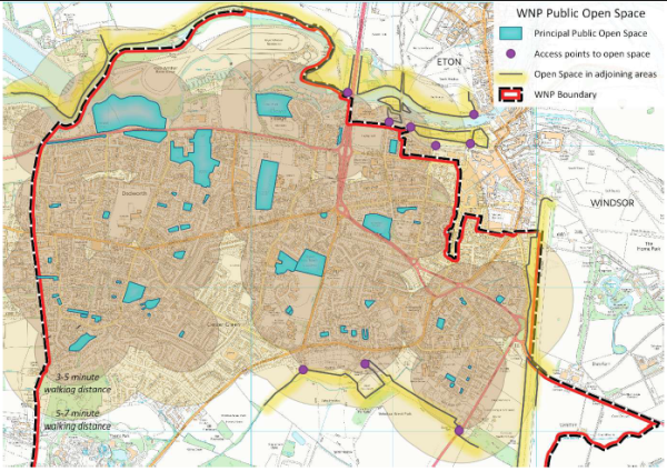
5.2.12 Most of Windsor Great Park is outside of the recommended 10-minute walking distance for much of West Windsor. Likewise, the access to the Thames path on the north bank of the Thames is limited to two crossing points in Windsor, which are the Royal Windsor Way Bridge and Windsor & Eton Bridge. These access points are a considerable distance from some parts of Windsor.
5.2.13 Recent and future expected population increases (through a higher number of, or density within, developments) during the Plan period indicate that more public open space will be required to maintain both quantitative and qualitative standards for local communities, and that overall provision of areas of open space is falling behind what is needed to keep up with population growth.
5.2.14 Under the FIT standards, RBWM will require an additional 6 ha of Amenity Green Space and 30 ha of space for Children and Young People between 2011 and 2031. Finding such additional spaces is very difficult and will need imaginative solutions. Without such additional urban spaces, the pressure on Windsor Great Park and its environmentally sensitive and special landscapes and Natural and Semi Natural Green spaces (as well as other edge of town open spaces) will increase even more, and threaten greater environmental degradation.
Therefore, the WNP will support the protection of existing spaces, and where possible will seek to improve accessibility, to encourage all new developments to imaginatively add to public and private open space and at the same time to improve other green infrastructure and acquire new areas of open space.
Map 5 WNP Area Open Spaces Walking Distances
POLICIES – Open Space
OS.01
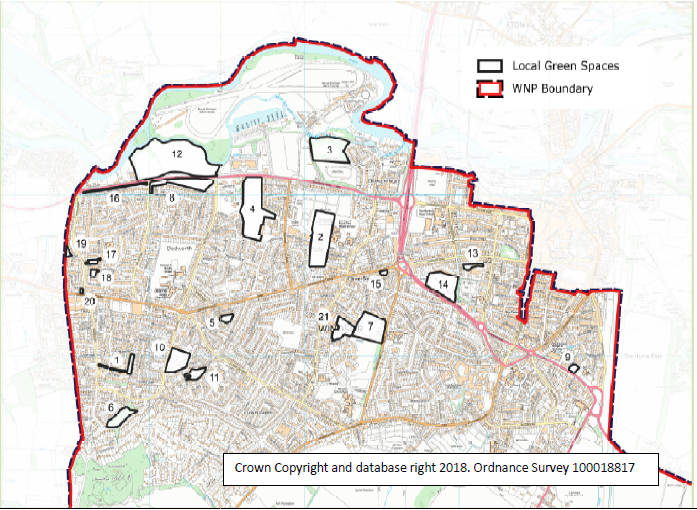
The spaces listed below and numbered as per Map 6 and identified in Appendix 1 as LGS are to be designated as “Local Green Space” and shall be protected from development in accordance with national policy.
Map 6 WNP Area- Designated Local Green Spaces
|
Designated Local Green Space Maps
All maps © Crown Copyright and database right 2018. Ordnance Survey 100018817 |
||
|---|---|---|
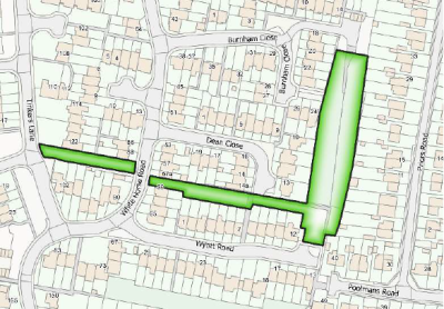
| 1. |
Castle Farm Spinney Castle Farm Spinney runs north to south to the west of Priors Road starting from Burnham Close to the north and finishing just short of Wyatt Road to the south. A narrow green corridor with a path links the spinney to White Horse Road and across to Tinkers Lane and Basford Way. |
|
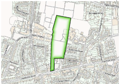
| 2. |
Clewer Memorial Recreation Ground Clewer Memorial Recreation Ground is located on Dedworth Road between the Three Elms junction and St. Andrews Avenue. It has both car and pedestrian access (not shown on map). Pedestrians are also able to enter the park from Oak Lane, East Crescent and Shirley Avenue. |
|
| 3. |
Clewer Park Clewer Park is in Clewer Village near St. Andrew's Church and behind the residential area off Mill Lane (also called Clewer Park). It is 3.9 ha. |
|
| 4. |
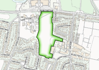
Dedworth Manor and Sawyers Close Between Maidenhead Road, Sawyers Close and Hanover Way, Dedworth Manor open space houses playing fields, a children's play area and many trees and saplings. |
|
| 5. |
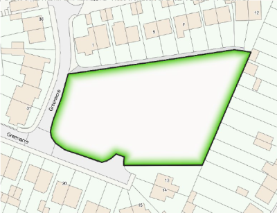
Greenacre This AGS abuts Greenacre to the East. |
|
| 6. |
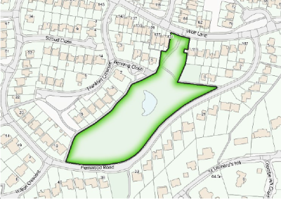
Hemwood Dell Mostly wooded area located between Wolf Lane/Benning Close, Franklyn Crescent/Hemwood Road. It is accessed from all of those roads via footpaths. |
|
| 7. |
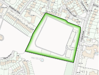
Imperial Park The Park is located on the western side of Imperial Road, which provides pedestrian, cycle and car access to the site with an additional pedestrian/cycle access from Clewer New Town. It can also be accessed from the eastern side of Imperial Road by the pedestrian bridge. |
|
| 8. |
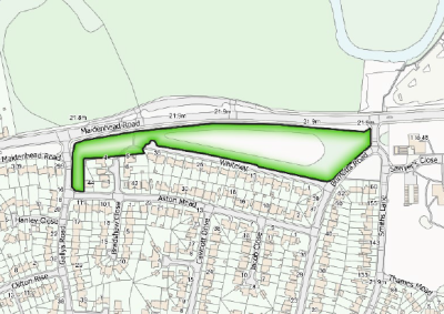
Maidenhead Road AGS2 This is located south of the A308 Maidenhead Road between Gallys Road and Smiths Lane. To the south of the space is the residential road, “Whiteley”. |
|
| 9. |
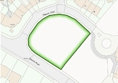
Osborne Road–Chaucer Close Open green space at the entrance to Chaucer Close and Local Equipped Play Area on Osborne Road. |
|
| 10. |
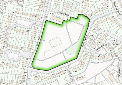
Osgood Park This is located between Wolf Lane, Fuzzens Walk and Foster Avenue. |
|
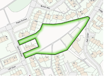
| 11. |
Park Corner This is surrounded by Burton Way, Park Corner, Keeler Close, Camm Avenue and Foster Avenue. |
|
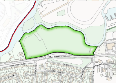
| 12. |
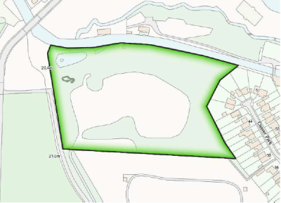
Sutherland Grange Sutherland Grange Nature Reserve is located on the Maidenhead Road (A308) across from Whiteley (no. 21, WNP Appendix 1) between the egresses of Smiths Lane and Gallys Road. |
|
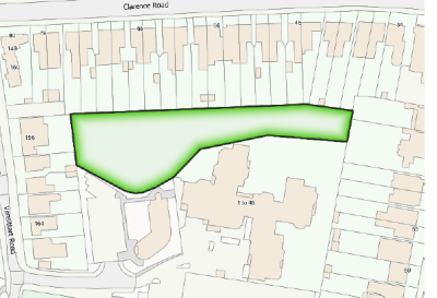
| 13. |
Trinity Wildlife Garden Trinity Wildlife Garden (0.39 ha) lies on the boundary of the Trinity Place / Clarence Crescent CA. Accessed from the back of Clarence Rd Medical Centre carpark, off Vansittart Road (NCN4) due south of Clarence Rd / Vansittart Rd junction and immediately NE of Vansittart Recreation Ground. |
|
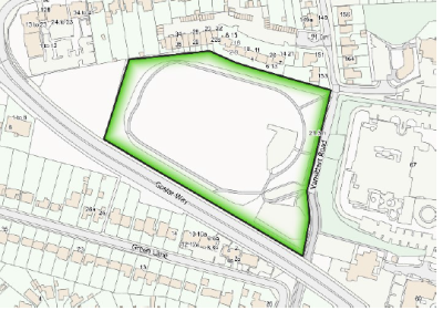
| 14. |
Vansittart Recreation Ground Vansittart Recreation Ground is a roughly rectangular parcel of ground, about 2.5 ha in area, between Goslar Way and the south end of Vansittart Road which is closed to motor traffic. There are access points from Vansittart Road where there is a small car park and off Goslar Way. Footpaths give access to Alma Road and under Goslar Way to Green Lane. |
|
| 15. |
Clarence Road Gardens This is at the front of the Trevelyan development immediately west of the Clarence Road Roundabout. |

|
| 16. |
Maidenhead Road AGS 1 This space is located on the south side of the A308 Maidenhead Road, between Rudlesway and Gallys Road. There are two parts to this – a narrow strip parallel to the Maidenhead Road and a small square at the end of Redford Road. To the south of the space is the separate residential road, having the “Maidenhead Road” address. |
|
| 17. |
Reed Way/Birch Grove This Amenity Green Space (AGS) is to the North of Reed Way, adjoining Birch Grove (56A). |
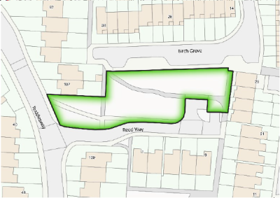
|
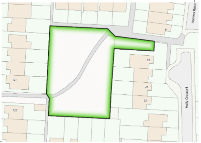
| 18. |
Reed Way/Holly Crescent This space is to the South of Reed Way with access by footpath from Reed Way and Holly Crescent. Access is also possible via footpath between 121 & 123 Rudlesway (56B). |
|
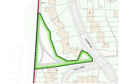
| 19. |
Willows Path NSN/AGS This NSN and AGS is a triangle of green space located on the Western side of the Laing Estate. It lies on the Willows Path (which connects Maidenhead Road to Dedworth Road) and immediately to the rear of Nos. 28–36 Rudlesway. A public footpath and green verge connect to Rudlesway. |
|
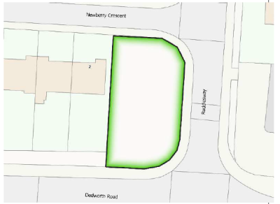
| 20. |
Dedworth Road/Rudlesway/Newberry Crescent This area is on the NW corner of the junction of Dedworth Road and Rudlesway (Southern end), occupying open land between Dedworth Road and the entrance to Newberry Crescent. |
|
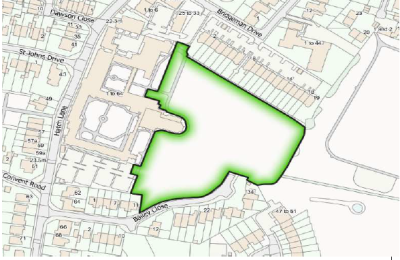
| 21. |
Convent Park Convent Park is located behind the Convent Court, Grey Court and Cloisters residential developments (formerly the Convent of St. John the Baptist, Chapel and grounds) between Bridgeman Drive, Hatch Lane and the back of Imperial Park. Access is from Bridgeman Drive, off Hatch Lane. |
|
OS.02
i. In existing residential developments, open space which has already been provided through previous planning permissions should be retained in order to protect and ensure sufficient amenity on these sites. Where additional development is proposed which could result in the loss of on-site open space, proposals should be supported by–
a. an open space assessment to demonstrate that the open space is no longer needed, and the provision of
b. an equivalent or better alternative provision to be made nearby, since open space must be located close to the residential area it serves.
ii. Allocation of new areas of open space will be supported. Should any major site be redeveloped during the plan period a new public open space should be provided within the development.
iii. Proposals which improve the quality of public open space will also be supported, including the following provision of facilities in appropriate locations:
REASONED JUSTIFICATION
5.2.15 It is recognised that national and local policy support the creation of and afford protection to, public open space. Policy OS.01 designates areas of Local Green Space that are demonstrably special to the community, where development will be managed as per in Green Belts, and Policy OS.02 supports the protection of existing and the creation of new public open space. OS.01 The NPPF (Para 100) allows communities to nominate some green areas as “Local Green Space” (as long as they fulfil certain criteria). Appendix 1 explains how each identified space meets LGS criteria15.
5.2.16 OS.02 Existing Local plan standards oblige developments to provide 15% AGS, and the WNP is supportive of this level of provision.
5.2.17 Amenities such as children’s play areas and facilities for young people are scattered through the area. Clearly there is scope for more, particularly for young people and in the west of town.
5.2.18 This policy aims to encourage best practice in Open Space provision 16 and to reinforce the standards to be applied in the emerging BLP, to maintain the standards in our area. As already discussed, an expected rise in the number of residents in the WNP area of around 20% by 2030 in the WNP area will place increasing pressure on all current resources and infrastructure.
5.2.19 Designing developments imaginatively to maximise the opportunity for open space within the site can help, for example with gardens on top of parking areas, or green rooftop gardens and balconies.
5.2.20 Accessibility is not just about distance. Users have commented that some of our open spaces have no toilet facilities, limiting the amount of time people can use them, and few bins and benches. Providing facilities increases the number of people who can use them and the length of time they can be there, thereby widening their usage.
5.2.21 If there were another crossing point 17 of the River Thames nearer resident’s homes in the west of Windsor giving access to the Thames Path National Trail (on the north bank of the Thames) then recreation possibilities would be improved. However, it has not been possible to find a site for this within the WNP area, but the aspiration remains for the future.
5.2.22 Project: Bins and benches (See section 11).
CONTEXT
5.3.1 The presence of green infrastructure and biodiversity is a requirement for environmental sustainability and the health of ecosystems. The NPPF18 encourages healthy green networks and linkages between them, and the recent emerging Borough Design Guide 2019 also encourages a healthy green infrastructure.
5.3.2 Windsor has been blessed historically by many tree lined streets, verges and gardens, hedgerows, and parks which together create a green character and feel, as well as providing a network that enables the opportunity for wildlife and biodiversity to thrive.
5.3.3 Combined with important biodiversity areas around the fringes of town19, these form the green infrastructure.
5.3.4 Increasingly dense development may lead to loss of biodiversity as well as a loss of green character, spaciousness and visual amenity and to the loss of green links. Individual developments in themselves may only have small effects on biodiversity and character but cumulatively can cause disruption to a network and contribute to significant declines in biodiversity and ultimately in extinctions.
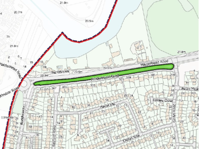
5.3.5 Green Corridors provide important links between areas in a network. There are only two officially RBWM designated “Green Corridors”20 (see Glossary) in the WNP area – one is the River Thames, and the other is the Willows Path (between Ruddlesway and the former Wyvale Garden Centre on the edge of West Windsor). Green Corridors require strips of land alongside pathways or roads. It is often not feasible in a largely urban area to provide new strips of land alongside existing roads and paths. However, we want to recognise that hedgerows, verges and trees, often on private land, function as part of the green infrastructure network, and to encourage greening and re-greening, not just within the limited definition of Green Corridors.
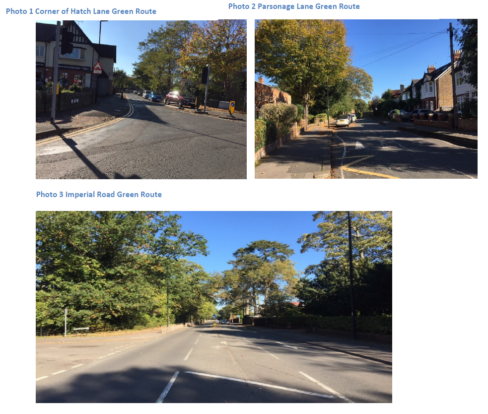
5.3.6 Many suburban and through roads can be described as “green routes” owing to their largely green character, with street trees, verges, and green shrubs and trees in gardens and plot boundaries. As well as providing insect and wildlife habitats and vegetation, these also act as connectors to other green areas and help form a green network. Examples are Winkfield Road, Imperial Road and Goslar Way, Osborne Road and Alma Road, Sheet Street Road and Kings Road, Maidenhead Road, and the Royal Windsor Way, Bolton Ave, Vale Road, Hatch Lane, Parsonage Lane and Mill Lane. The through roads particularly also set the scene for the experience of the town as people arrive and transit through it, or as they head towards the centre. They also help to provide the wider attractive setting for Windsor Castle and Great Park.
5.3.7 There is strong pressure on all green aspects from development. Linkages between green spaces are gradually lost, and long standing and naturally occurring biodiversity is often badly damaged when new developments are built. Flooding is made worse by loss of vegetation. Fencing and walling often creates barriers to wildlife access.
5.3.8 The need for parking space is particularly acute, so that trees and green front boundaries or gardens are often lost when front gardens are converted for parking and increasingly dense developments are built. Bigger buildings obviously take up more land and loss of greenery creates a more urban feel. Some people feel that street trees are a nuisance, resulting in them not being replaced in some places when they die.
5.3.9 RBWM already has a programme of replacing street trees where they have been lost, as well as tree protection, and we would like this to be prioritised on all roads where there are gaps, but particularly on through roads. We also wish to encourage developers to consider the green aspect more.
5.3.10 The WNP seeks to strengthen the network of roads with a substantially green appearance, with the intention that these “Green Routes” to maintain and enhance the links between green areas and improve the ultimate function of the green infrastructure both on the edge of town and through town. This will help maintain wildlife and biodiversity as well as character and help to bring nature into the town to mitigate losses caused by more dense development.
POLICIES Green and Blue Infrastructure Network
BIO.01
BIO.02: Green Routes
Map 7 -WNP Area Green Routes

BIO.02 (Contd)
5.3.11 Taken together these policies should a) help to consolidate the green and blue infrastructure, providing good safe access for human beings, wildlife and wider elements of biodiversity to and through open spaces and the natural environment. We wish to encourage best practice in greening the town.
5.3.12 BIO.01 These policies aim to preserve and enhance biodiversity and the green feel of the town in new developments thereby maintaining character, and improve the appearance of the streets, including parking in front gardens. We also wish to encourage the addition of trees where appropriate.
5.3.13 Edible planting (except where this would be undesirable on main roads because of pollution) is good for wildlife and humans. We wish to encourage landscaping and replacement of green boundaries, as well as the maintenance of such landscaping.
5.3.14 Frequently, recent developments have completely paved over front driveways and made no or only cursory provision for greenery by planting in pots which are not maintained, and have thereby damaged the street scene and area character. We wish to encourage alternatives to this.
5.3.15 Recent Royal Horticultural Society reports22 have shown how it is possible to improve the look of off-street parking with lots of planting, and this approach is endorsed by the WNP. Green treatments need not take up much space in order to play a meaningful environmental role.
5.3.16 Planting that contributes to the biodiversity of the area and supports the establishment of green routes is particularly encouraged.
5.3.17 Retention of trees on development sites is covered by Borough policy. Trees help mitigate drainage and flooding issues, retaining and absorbing water, so they are particularly useful on sites where surface water drainage can be a problem such as along Hatch Lane, although it is recognised that high water-seeking varieties should only be used only where flood risk is an issue.
5.3.18 Where mature trees cannot avoid being lost, we wish to encourage developers to replace them with trees chosen from varieties appropriate to the setting. Recommendations for suitable planting can often be found in the Townscape Assessment.
5.3.19 BIO.02 We wish to encourage and maintain a strong green infrastructure with a network of linked green and quiet routes and spaces, so that nature has a chance to thrive despite being in an urban area that is becoming more densely built up. We wish to encourage and maintain green routes as links between green spaces, including urban open spaces. Enhancing links between open spaces is as important as the development of new sites. Development over the plan period is encouraged to capitalise on opportunities to increase and enhance the network, creating links between open spaces. The routes we have chosen are important as they are part of the existing green infrastructure and form part of the essential green character and historic fabric of Windsor. These routes are often busy roads and are already at least partially tree lined or partially green, and are edged by hedges and trees in gardens or verges, or are bounded by substantial green open spaces and gardens on one or both sides in parts. Many are gradually having their green feel eroded through development, which has taken out or is expected to take out greenery within them or on their boundaries, so eroding their network function as well as historic character. Some such as Dedworth Road and Clewer Hill Roads currently have less current greenery than others and possibly less scope for it, but we aspire to improve them where possible.
5.3.20 Encouraging the retention and re-establishment of greenery particularly will help to join and maintain links between the open Green Belt areas which surround Windsor to the parks, Thames and areas of informal green space or cycle routes within it, particularly if fencing or walls between them are designed with this in mind. Ditch banks can be managed in such a way to maintain their natural aspects and quality. Developments fronting onto roads can allow for wildlife friendly boundary treatments and planting, and streets can include trees and grass verges where there is space. Where there is a conflict between proposed uses, such as between foot or cycle paths, or parking and green spaces and boundaries, design solutions which maximise green aspects are encouraged.
5.3.21 There are some green spaces which provide vital links in the green network. One such important link that we would like to see maintained is the buffer zone between LEGOLAND and the residential areas of St Leonards Hill. This is already Green Belt and has the dual function of connecting the Area of Special Landscape Importance at the top of St Leonards Hill to Winkfield Road and the rest of the Great Park on the other side of Winkfield Road, as well as providing its buffer functions for nearby residential areas.
Context
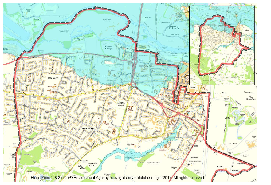
5.4.1 The NP area is affected by Flood Zones 2 and 3, defined in the NPPF and NPPG as having a medium to high risk of flooding from both the Thames and some of its tributaries, as well as from ground and surface water flooding. The water table is high in much of the area, and the underlying geology, particularly clay soil conditions, exacerbates surface drainage problems in some places.
5.4.2 Windsor has been protected by the Jubilee River flood relief scheme (since 2002) and the Bourne Ditch “Bund” embankment and sluice gate near Stag Meadow (since 1995) which have helped to mitigate against flooding. However, the Environment Agency still deems there to be a risk as rainfall events are likely to become more extreme in future, with 1 in a 1000 year flood events becoming 1 in a 100 year events, particularly in Critical Drainage Areas23.
5.4.3 Surface water flooding from run off is an increasing issue as areas that are hard paved increase with more development and speeds up runoff and exacerbates flooding.
5.4.4 A key sustainability objective for NPs is for new development to be co-ordinated with the infrastructure it demands and to take into account the capacity of existing infrastructure.
5.4.5 Both the Environment Agency and Thames Water have recommended that the WNP considers flooding and water supply issues in order to mitigate the effects of population growth and climate change.
5.4.6 Old Windsor which is downstream from Windsor receives all of Windsor drainage, and has a very serious risk of flooding.
5.4.7 Windsor’s sewage system relies on processing downstream at Ham Island Old Windsor and there is believed to be limited processing capacity for increased sewage volume from any source. Sustainable development in Windsor is therefore more important.
5.4.8 According to the Environment Agency, the WNP area also is part of the principal Water Supply Aquifer for the area and there are Groundwater Source Protection Zones (SPZ) within the area.
Map 8- WNP Flood Risk Zones 2&3 from river flooding
POLICIES – Flooding and Water Supply
WAT 01
Development should be made safe from flooding and not increase the risk of flooding elsewhere. Drainage on site should separate foul and surface water flows. The use of Sustainable Urban Drainage Systems will be supported.
Reasoned Justification
5.4.9 WAT 01 There is a medium to high flood risk across parts of the WNP area (see Map 8). Evidence comes from Environment Agency Flood Risk Maps of River and Surface Water Flooding.
5.4.10 The National Planning Policy Framework and National Planning Policy Guidance establishes a sequential test to be applied in respect of flood risk. Development should be located first where there is a lower risk of flooding, avoiding therefore areas of higher risk.
5.4.11 Sustainable Urban Drainage Systems (SUDS) help to provide flood resilience in a locally relevant, sustainable manner.
5.4.12 We strongly encourage the use of SUDS. Within the WNP area, subsoils vary, and where subsoils are clays SUDS may not be suitable so developers will need to take advice on this.
10 RBWM Local Plan 2003; RBWM Open Space Study/Audit 2008; RBWM Open Space Study 2019, RIBA City Health Check 2011; “Creating the Right Environment for Health” The Annual Report from the Director of Public Health RBWM July 2018.
11 Open Space typologies include Parks and Gardens; Natural and Semi Natural Green Space; Provision for Children and young people ; Recreation Grounds and Outdoor Sports facilities (e.g. Pitches, athletics tracks, bowling greens, tennis courts); Amenity Green Space near housing areas (for informal recreation); Green Corridors or links (which provide important human and wildlife access routes); Cemeteries and Allotments also provide open space.
12 The RBWM have adopted Fields in Trust standards which have superseded the former quantity and accessibility Natural England standards from the 1990s, and in the case of Parks and Gardens and Natural and Semi Natural green space recommend higher quantities of open space, and in the case of Provision for Children and Young People, lower quantities, Amenity Green Space about the same.
13 1968-69 Cmnd.4166 Report of a Departmental Committee of Inquiry into Allotments (Chairman: Professor H.Thorpe) (Allotments) House of Commons.
14 Most school playing fields are not usually open to the public unless through a club, allotments are usually open to members only, there are also some substantial private gardens (for example at Longbourn on Imperial Road and Clarence Crescent Gardens) and much Green Belt open space around the town is private and protected landscape sections of Windsor Great Park (e.g. Windsor Forest), or accessible only to users of Windsor Racecourse and Legoland. Some is allocated highways land, or has “permissive” access which can be withdrawn in future (some Crown Estate areas and footpaths). Some have specified opening times (Convent Public Park open space).
15 NPPF para 77 lists criteria for LGS: that it is of particular importance and is i. demonstrably special and holding particular local significance because of beauty, historic significance, recreational value, tranquillity or richness of its wildlife, ii. close to people’s homes, and iii. not an extensive tract of land. We have retained the use of and reference to the established typologies. Each space needs to be treated according to its merits.
16 Under RBWM standards of 4.3 ha of publicly accessible open space for every 1,000 residents in the local area, a population of for example 36,000, would require an overall quantity of around 154 hectares.
17 Current crossing points are at the Elizabeth Bridge and a footbridge several miles to the west in Bray.
18 NPPF Chapter 15 Conserving and enhancing the natural environment. RBWM Borough Wide Design Guide Reg 13 Consultation Draft Feb 2019.
19 As identified in the RBWM Landscape Character Assessment 2004.Biodiversity areas include Special Areas of Conservation, Windsor Ancient Forest, Great Park Areas of Special Scientific Interest.
20RBWM Landscape Character Assessment 2004
21 Royal Horticultural Society Front Garden Guide Front gardens: design inspiration / RHS Gardening
22Royal Horticultural Society Front Garden Guide file:///C:/Users/clair/AppData/Local/Temp/Temp1_Front%20Gardens%20RHS%20Summit.zip/RHS-Front-Garden-guide-(1).pdf
23 A critical drainage area is defined in the Town and Country Planning (General Development Procedure) (Amendment) (No. 2) (England) Order 2006 a Critical Drainage Area is “an area within Flood Zone 1 which has critical drainage problems and which has been notified… …the local planning authority by the Environment Agency”.
< Previous | ^ Top | Next >