This Appendix 1 lists all areas of Open Space within the WNP Area and further identifies the twenty-one Local Green Spaces (LGS) nominated in Policy OS.01 of this Neighbourhood Plan.
APPENDIX 1 OPEN SPACE
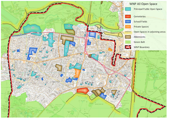
The following Map and Table lists all of the existing open spaces in the WNP Area defined in the RBWM Open Space Audit 2008 (OSA 2008) - Analysis Area 2 (Appendix F, pp.4-6). Open spaces created since 2008 have also been included (Items 51-60).
Within the following Table:
APPENDIX 1 OPEN SPACE
| REF | LOCATION | PARKS & GARDENS | NATURAL & SEMI NAT GREEN SPACES | GREEN CORRIDORS | AMENITY GREEN SPACE | PROVISION FOR CHILDREN | PROVISION FOR YOUNG PEOPLE | HIGHWAYS LAND | LOCAL GREEN SPACE REF |
|---|---|---|---|---|---|---|---|---|---|
| RBWM TYPOLOGIES | 1 | 2 | 3 | 4 | 5 | 6 | |||
| 1 | Basford Way (2 corner plots) Bruce Walk | 112 | |||||||
| 2 | Bruce Walk | 113 | |||||||
| 3 | Bulkeley Avenue | 58 | 59 | ||||||
| 4 | Castle Farm Spinney | 105 | H | 1 | |||||
| 5 | Clewer Memorial Recreation Ground | 88 | 89 144 | 143 | 2 | ||||
| 6 | Clewer Park | 154 | 3 | ||||||
| 7 | Dedworth Drive (corner of Stuart Way) | 132 | |||||||
| 8 | Dedworth Manor and Sawyers Close Park | 126 | 127 129 | 130 | 4 | ||||
| 9 | Filmer Road | 114 | |||||||
| 10 | Foster Avenue (see also #24) | 102 | |||||||
| 11 | Gardner Cottages Communal Gardens | 41 | |||||||
| 12 | Greenacre | 96 | 5 | ||||||
| 13 | Hemwood Dell | 108 | H | 6 | |||||
| 14 | Imperial Park | 83 | 465 | 466 | 7 | ||||
| 15 | Keeler Close | 98 | 99 | ||||||
| 16 | Keepers Farm Close N | 103 | H | ||||||
| 17 | Keepers Farm Close S | 104 | H | ||||||
| 18 | Knights Close | 136 | 137 | ||||||
| 19 | Loring Road | 131 | |||||||
| 20 | Losfield Road | 134 |
| REF | LOCATION | PARKS & GARDENS | NATURAL & SEMI NAT GREEN SPACES | GREEN CORRIDORS | AMENITY GREEN SPACE | PROVISION FOR CHILDREN | PROVISION FOR YOUNG PEOPLE | HIGHWAYS LAND | LOCAL GREEN SPACE REF |
|---|---|---|---|---|---|---|---|---|---|
| 21 | Maidenhead Road AGS 2 – Gallys Rd to Smiths Lane (aka Whiteley) | 125 | H | 8 | |||||
| 22 | Nightingale Walk | 60 62 | 61 | ||||||
| 23 | Chaucer Close, off Osborne Road | 65 | 66 | 64 | 9 | ||||
| 24 | Osgood Park (off Wolf Lane) | 101 | 10 | ||||||
| 25 | Park Corner | 100 | 474 | 11 | |||||
| 26 | Peel Close | 79 | |||||||
| 27 | Perrycroft and The Ridings | 94 | |||||||
| 28 | Princess Avenue (4× green spaces) | 80 81 82 | |||||||
| 29 | Ruddlesway (now re-developed as Reed Way – see 56A & B) | 140 | |||||||
| 30 | Not Used | ||||||||
| 31 | St Georges Close (off Smiths Lane) | 133 | |||||||
| 32 | Stuart Way (green spaces ×2) | 92 | |||||||
| 33 | Sutherland Grange | 124 | 12 | ||||||
| 34 | Trinity Wildlife Garden | 51 | 13 | ||||||
| 35 | Vansittart Recreation Ground | 55 471 | 53 | 54 | 14 | ||||
| 36 | Wolf Lane open area | 107 | H | ||||||
| 37 | Wolf Lane Play Area | 106 | H | ||||||
| 38 | Wolf Lane Spinney | 107 | H |
| REF | LOCATION | PARKS & GARDENS | NATURAL & SEMI NAT GREEN SPACES | GREEN CORRIDORS | AMENITY GREEN SPACE | PROVISION FOR CHILDREN | PROVISION FOR YOUNG PEOPLE | HIGHWAYS LAND | LOCAL GREEN SPACE REF |
|---|---|---|---|---|---|---|---|---|---|
| RBWM TYPOLOGIES | 1 | 2 | 3 | 4 | 5 | 6 | |||
| 51 | Clarence Road Gardens | Y | 15 | ||||||
| 52 | Link: Alma Road to Vansittart Road, including footpath | Y | H | ||||||
| 53 | Longbourn Open Space, Imperial Road | Y | |||||||
| 54 | Maidenhead Road AGS 1 - Ruddlesway to Gallys Rd | Y | H | 16 | |||||
| 55 | Nightingale Walk corner plots | Y | |||||||
| 56A | Reed Way 1 | Y | H | 17 | |||||
| 56B | Reed Way 2 | Y | H | 18 | |||||
| 56C | Willows Path open triangle of land | Y | H | 19 | |||||
| 56D | Dedworth Rd / Ruddlesway junction: NW corner | Y | H | 20 | |||||
| 57 | Stephensons Drive | Y | |||||||
| 58 | Wood Close (green spaces × 5) | Y | |||||||
| 59 | Wood Close Play Area | Y | |||||||
| 60 | Convent Park, Bridgeman Drive | Y | 21 |
This section contains justifications for the designation of twenty one (21) Local Green Spaces (LGS) as per Policy OS.01 of Windsor Neighbourhood Plan.
Title: CASTLE FARM SPINNEY LGS 1
|
Location: Castle Farm Spinney runs north to south to the west of Priors Road starting from Burnham Close to the north and finishing just short of Wyatt Road to the South. A narrow green corridor with a path links the spinney to White Horse Road and across to Tinkers Lane, and Basford Way. |

|
Why is this space demonstrably special? |
It is a small woodland habitat for wildlife. It contains mature and established trees, and shrubs. A soft path meanders north to south and this path is maintained with wood chips and log borders. It sits just several metres north of Wolf Lane Spinney thus providing a ‘green corridor’ of spinneys, and a ‘green lung’ for this area. It is a gated spinney with access to the north and south and also to the west via Burnham Close ‘spur’. A green corridor with asphalt path then leads west to Basford Way. This green corridor is mainly grassed and contains shrubs, mature trees and saplings. This forms part of the path network which enables residents to access facilities on foot, avoiding the road network. A dog waste bin is provided at the southern entrance. |
|
Is the retention of this open space consistent with Borough Local Plan policies for sustainable development? |
Yes |
|
Does this land have planning permission? |
No |
|
Does this land already benefit from protection, such as Green Belt, National Park, AONB, SSSI, Scheduled Monument or Conservation Area? |
Yes. The RBWM Open Space Audit (2008) Appendix F
|
|
Is this space in close proximity to the community it serves? |
Yes. This sits in the middle of dense housing, no higher than two storey. |
|
Is it capable of enduring beyond the plan period? |
Yes. This sits in the middle of dense housing, no higher than two storey. |
Is this space an extensive tract of land? |
No |
Is the space located within a new development and if so, how is it demonstrably special or of local significance? |
No |
Who is the landowner? Have they been consulted and, if so, what are their views on designation? |
RBWM |
How will the green space be managed in the future? |
RBWM |
|
Location Clewer Memorial Recreation Ground is located on Dedworth Road between the Three Elms junction and St. Andrews Avenue. It has both car and pedestrian access (not shown on map). Pedestrians are also able to enter the park from Oak Lane, East Crescent and Shirley Avenue. |
|
Why is this space demonstrably special? |
1) Historic importance: This land is part of the Ancient Manor of Clewer (Saxon) which pre-dates construction of Windsor Castle. The Park contains a monument to the men of Clewer who fell in both World Wars, inaugurated on 28th January 1923 in the presence of the Earl of Athlone. Around 190 names are listed here. 2) Natural habitats and wildlife: A series of planting schemes around the perimeter of the park provide important “green links” for wildlife and biodiversity. The park received its third Green Flag award in July 2012 in recognition of having achieved the national standard for parks and green spaces (England and Wales). 3) Beauty, Tranquillity and Recreational value: Clewer Memorial Recreation Ground is close to residential areas and schools and provides a range of opportunities for individuals of all ages to enjoy various outdoor activities. It contains the following facilities:
|
|
Is the retention of this open space consistent with Borough Local Plan policies for sustainable development? |
Yes. A User Group including sports users of the park, residents, Community Wardens and RBWM representatives has been set up to ensure as far as possible that the park is meeting the needs of the local community. |
Does this land have planning permission? |
No |
|
Does this land already benefit from protection, such as Green Belt, National Park, AONB, SSSI, Scheduled Monument or Conservation Area? |
Yes. RBWM designated public park |
Is it capable of enduring beyond the plan period? |
Yes |
Is this space in close proximity to the community it serves? |
Yes |
Is this space an extensive tract of land? |
No |
|
Is the space located within a new development and if so, how is it demonstrably special or of local significance? |
No |
|
Who is the landowner? Have they been consulted and, if so, what are their views on designation? |
RBWM |
How will the green space be managed in the future? |
An RBWM site management policy is currently in place and covers the period from 2009–2019. |
|
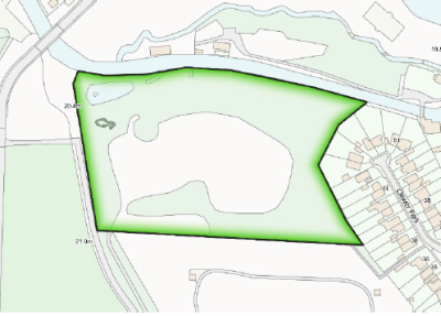
Location Clewer Park is in Clewer Village near St. Andrew’s Church and behind the residential area off Mill Lane (also called Clewer Park). It is 3.9 hectares. |
|
Why is this space demonstrably special? |
1) Historic importance: Part of the Ancient Manor of Clewer (Saxon) which pre-dates the construction of Windsor Castle. Garden of 15th c. house built near St. Andrew’s Church. Housed Clewer Barracks (constructed 1796–1800) for Royal Horse Guards and Blues. Owned (1859–89) by Sir Daniel Gooch – industrialist, engineer, GWR Chairman. Clewer Park Estate sold in 1955 for development of 60 houses. One third of remaining land taken over by the Allotment Association, the rest retained by RBWM as important public parkland. 2) Natural habitats and wildlife: The Park provides important support for biodiversity. Over 30 species of bird (e.g. finches, Chiffchaffs, Goldcrests, Green and Spotted Woodpeckers, Kingfishers, Swans, Herons) are resident in the Park. Habitats include open grassland with individual and groups of trees and hedgerows; coppiced Hazel and pruned Sycamore (part of RBWM’s ongoing maintenance programme); stream, pond and river access; and nesting boxes installed in 2004 for Tits, Tree Creepers and Tawny Owls. 3) Beauty, Tranquillity and Recreational value: The Park was created specifically to provide quiet informal public open space for relaxation and informal activities, including dog-walking. Its beauty reflects the Manor’s long, evolving history:
|
|
Is the retention of this open space consistent with Borough Local Plan policies for sustainable development? |
Yes. The RBWM Open Space Audit (2008) states that: |
Does this land have planning permission? |
No |
|
Does this land already benefit from protection, such as Green Belt, National Park, AONB, SSSI, Scheduled Monument or Conservation Area? |
Yes. Green Belt and Designated parkland (RBWM) purchased for specific purpose of providing informal open space for residents and the wider community and protecting the land from further development. The Park is adjacent to the Mill Lane Conservation Area and has a significant historic connection with the CA. |
Is it capable of enduring beyond the plan period? |
Yes |
Is this space in close proximity to the community it serves? |
Yes |
Is this space an extensive tract of land? |
No |
|
Is the space located within a new development and if so, how is it demonstrably special or of local significance? |
See comments above |
|
Who is the landowner? Have they been consulted and, if so, what are their views on designation? |
RBWM |
How will the green space be managed in the future? |
RBWM |
|
Location |
|
Why is this space demonstrably special? |
|
|
Is the retention of this open space consistent with Borough Local Plan policies for sustainable development? |
Yes |
Does this land have planning permission? |
No |
|
Does this land already benefit from protection, such as Green Belt, National Park, AONB, SSSI, Scheduled Monument or Conservation Area? |
Yes. The RBWM Open Space Audit, Appendix F list:
|
Is it capable of enduring beyond the plan period? |
Yes |
Is this space in close proximity to the community it serves? |
Yes |
Is this space an extensive tract of land? |
No |
|
Is the space located within a new development and if so, how is it demonstrably special or of local significance? |
Yes. It sits in the heart of the residential area, with the Sawyers Close flats adjacent to the site. There is public access from multiple points along its boundary. |
|
Who is the landowner? Have they been consulted and, if so, what are their views on designation? |
RBWM |
How will the green space be managed in the future? |
RBWM maintained as part of protected RBWM Open Space provision. |
|
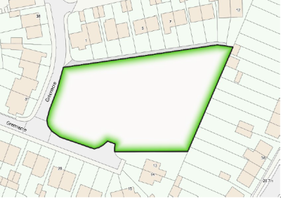
Location: This AGS abuts Greenacre to the East. |
|
Why is this space demonstrably special? |
Greenacre is a no-through road, in which the houses face the space on three sides; the eastern side abuts the back gardens of houses in Kentons Lane. The front or back gardens of many houses have hard standing for cars and thus this green space provides a valuable amenity. Wooden posts are erected round the perimeter to prevent cars from parking on the space. It contains well-established, mature trees and shrubs. It is used by children for play. |
|
Is the retention of this open space consistent with Borough Local Plan policies for sustainable development? |
Yes |
Does this land have planning permission? |
No |
|
Does this land already benefit from protection, such as Green Belt, National Park, AONB, SSSI, Scheduled Monument or Conservation Area? |
Yes. The RBWM Open Space Audit appendix F:
|
Is it capable of enduring beyond the plan period? |
Yes |
Is this space in close proximity to the community it serves? |
Yes, it is surrounded by the terraced houses of Greenacre. |
Is this space an extensive tract of land? |
No |
|
Is the space located within a new development and if so, how is it demonstrably special or of local significance? |
No |
|
Who is the landowner? Have they been consulted and, if so, what are their views on designation? |
Private green owned and maintained by The Greenacre Residents’ Association Ltd. |
How will the green space be managed in the future? |
Greenacre Residents’ Association Ltd |
|
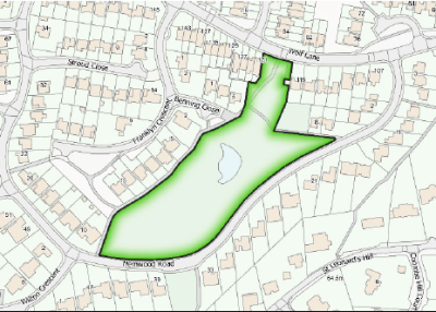
Location: Mostly wooded area located between Wolf Lane/Benning Close, Franklyn Crescent/Hemwood Road, it is accessed from all of those roads via footpaths. |
|
Why is this space demonstrably special? |
This is a Natural and Semi Natural Green Space and a place for valued habitat and wildlife. It has formal access points from Wolf Lane, Benning Close and three from Hemwood Road, as well as informal access points. It has asphalt paths running along the western side and from Wolf Lane South East to Hemwood Road. It has a marked, but not asphalt, path from the western corner of Hemwood Road to the centre and looping back onto Hemwood Road further east. It is well used by walkers and children and provides a “green” link from Hemwood Road to Wolf Lane. A “clean up after your dog” bin is provided. It contains mature and well-established trees and shrubs. |
Is the retention of this open space consistent with Borough Local Plan policies for sustainable development? |
Yes |
Does this land have planning permission? |
No |
|
Does this land already benefit from protection, such as Green Belt, National Park, AONB, SSSI, Scheduled Monument or Conservation Area? |
Yes. The RBWM Open Space Audit Appendix F:
|
Is it capable of enduring beyond the plan period? |
Yes |
Is this space in close proximity to the community it serves? |
Yes. It is surrounded on all sides by houses. |
Is this space an extensive tract of land? |
No |
|
Is the space located within a new development and if so, how is it demonstrably special or of local significance? |
No |
|
Who is the landowner? Have they been consulted and, if so, what are their views on designation? |
Privately owned. Various private owners2. |
How will the green space be managed in the future? |
RBWM |
|
Location: The Park is located on the western side of Imperial Road, which provides pedestrian, cycle and car access to the site with an additional pedestrian/cycle access from Clewer New Town. It can also be accessed from the eastern side of Imperial Road by the pedestrian bridge. |
|
Why is this space demonstrably special? |
1) Historic importance: 2) Natural habitats and wildlife: These also create visual respite and air pollution ‘buffers’ between neighbouring residential areas and the heavy volumes of traffic on Imperial Road. 3) Beauty, Tranquillity and Recreational value: |
|
Is the retention of this open space consistent with Borough Local Plan policies for sustainable development? |
Yes |
Does this land have planning permission? |
No |
|
Does this land already benefit from protection, such as Green Belt, National Park, AONB, SSSI, Scheduled Monument or Conservation Area? |
No |
Is it capable of enduring beyond the plan period? |
Yes |
Is this space in close proximity to the community it serves? |
Yes. See comments above. |
Is this space an extensive tract of land? |
No |
|
Is the space located within a new development and if so, how is it demonstrably special or of local significance? |
No |
|
Who is the landowner? Have they been consulted and, if so, what are their views on designation? |
RBWM |
How will the green space be managed in the future? |
RBWM management programme |
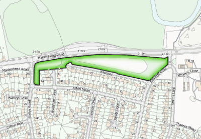
|
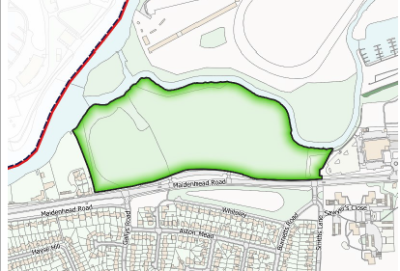
Location: This is located south of the A308 Maidenhead Road between Gallys Road and Smiths Lane. To the south of this space is the residential road, “Whiteley.” |
|
Why is this space demonstrably special? |
This space provides a buffer to the traffic on Maidenhead Road in terms of noise, sight and pollution. This strip is in layers – working south from the main Maidenhead Road there is a wide pedestrian/cyclist shared asphalt path, a grass verge, a high and well established beech hedge, and finally grass. There is a wide variety of mature and well-established trees, saplings and areas of natural planting flowers/grass. It is well-used by dog walkers and dog waste bins are provided. Cycling is forbidden. This style of space is complemented by the open front gardens of neighbouring properties. An asphalt footpath runs through from Ballard Green to Whiteley and through an entrance in the hedge, leading to the pedestrian controlled traffic lights across the Maidenhead Road to the main entrance to Sutherland Grange. This space provides a “green” route for Dedworth residents to access Sutherland Grange. |
|
Is the retention of this open space consistent with Borough Local Plan policies for sustainable development? |
Yes |
Does this land have planning permission? |
No |
|
Does this land already benefit from protection, such as Green Belt, National Park, AONB, SSSI, Scheduled Monument or Conservation Area? |
Yes. The RBWM Open Space Audit 2008 Appendix F
|
Is it capable of enduring beyond the plan period? |
Yes |
Is this space in close proximity to the community it serves? |
Yes. To the south are detached houses facing this space. |
Is this space an extensive tract of land? |
No |
|
Is the space located within a new development and if so, how is it demonstrably special or of local significance? |
No |
|
Who is the landowner? Have they been consulted and, if so, what are their views on designation? |
RBWM |
How will the green space be managed in the future? |
RBWM |
|
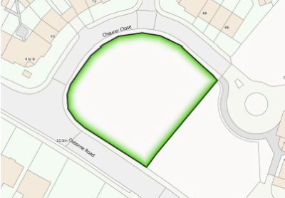
Location: Open Green Space at the entrance to Chaucer Close and LEAP (Local Equipped Area of Play) on Osborne Road. |
|
Why the space is of particular importance? |
It is an area of grass surrounded by a low fence, set at the entrance to Chaucer Close and with one side along the road. It provides a visual break in the built-up area and allows a full view of the Castle from the busy Osborne Road. There is a well-used grassed ball and general play area, and next to it, an equipped play area for young children (LEAP) surrounded by fences, trees, and shrubs on Osborne Road. Both share a boundary with Queen Anne School, the entrance of which is through Chaucer Close and next to the grassed area. |
Consistent with Local Plan policies for sustainable development |
Yes |
Does the land have planning permission? |
No |
Does the land already benefit from protections? |
Yes |
Capable of enduring beyond the plan period? |
Yes |
Is space in close proximity to the community it serves? |
Yes. Surrounded by houses on Chaucer Close and Osborne Road. |
Is the space an extensive tract of land? |
No |
|
Is the space located within a new development and if so, how is it demonstrably special or of local significance? |
No. Chaucer Close was developed in the 1980s–1990s on a site that was formerly partly scrubland. This space was designated as open space at that time and preserves an important view of the castle. |
|
Have the landowners been consulted and if so what were their views on designation? |
RBWM |
How will the green space be managed in the future? |
RBWM |
|
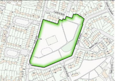
Location: This is located between Wolf Lane, Fuzzens Walk and Foster Avenue. |
|
Why is this space demonstrably special? |
This park is named after Peter Osgood, the well-known Chelsea footballer who lived locally. It is on a slight hill and thus affords views of the rolling Buckinghamshire Hills to the north. Within the park there is a secure play area for young children, which is grassed and contains play equipment and a bench. It can be accessed from two points. The park contains shrubbery, saplings, well-established and mature trees. There is a small garden at the eastern side. There are numerous dog waste bins, a picnic area and benches. Paths run through the park linking Fuzzens Way to Wolf Lane and Foster Avenue. In the spring there is a profusion of daffodils and one area is designated the Marie Curie Cancer Care Field. Wooden posts prevent cars from parking on the park. It is used by walkers and runners. The housing estate to the south off Foster Avenue contains many footpaths and alleys which give residents easy walking access to the park. |
|
Is the retention of this open space consistent with Borough Local Plan policies for sustainable development? |
Yes |
Does this land have planning permission? |
No |
|
Does this land already benefit from protection, such as Green Belt, National Park, AONB, SSSI, Scheduled Monument or Conservation Area? |
Yes. The RBWM Open Space Audit (2008) Appendix F
|
Is it capable of enduring beyond the plan period? |
Yes |
Is this space in close proximity to the community it serves? |
Yes. It is surrounded on all sides by single storey dwellings, terraced houses, semi-detached houses, and two-storey blocks of flats. A Scout Hut sits just beyond the northwest corner. |
Is this space an extensive tract of land? |
No |
|
Is the space located within a new development and if so, how is it demonstrably special or of local significance? |
No |
|
Who is the landowner? Have they been consulted and, if so, what are their views on designation? |
RBWM |
How will the green space be managed in the future? |
RBWM |
|
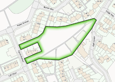
Location: This is surrounded by Burton Way, Park Corner, Keeler Close, Camm Avenue and Foster Avenue. |
|
Why is this space demonstrably special? |
This Amenity Green Space contains the Keeler Close Kickabout Area for young children, with saplings, a grassed area and a hard-surfaced basketball/multi-use court. It contains the secure Keeler Close Play Area for younger children, which is mainly tarmacked with play equipment, benches and waste bins. The green space, which has both saplings and well-established trees, is crisscrossed with asphalt paths running from Park Corner, Burton Way, two from Foster Avenue and two from Camm Avenue. The main path connecting Park Corner with Foster Avenue is lit by street lamps. Golf is forbidden. It is used by dog walkers and there are dog poo bins. |
Is the retention of this open space consistent with Borough Local Plan policies for sustainable development? |
Yes |
Does this land have planning permission? |
No |
|
Does this land already benefit from protection, such as Green Belt, National Park, AONB, SSSI, Scheduled Monument or Conservation Area? |
Yes. The RBWM Open Space Audit, Appendix F:
|
Is it capable of enduring beyond the plan period? |
Yes |
Is this space in close proximity to the community it serves? |
Yes. The space is surrounded by two-storey flats, houses and bungalows, some of which have open access to the space. In all, there are six access points to this space. |
Is this space an extensive tract of land? |
No |
|
Is the space located within a new development and if so, how is it demonstrably special or of local significance? |
No |
|
Who is the landowner? Have they been consulted and, if so, what are their views on designation? |
RBWM |
How will the green space be managed in the future? |
RBWM |
|
Location: Sutherland Grange Nature Reserve is located on the Maidenhead Road (A308) across from Whiteley (no. 21, WNP Appendix 3) between the egresses of Smiths Lane and Gallys Road. |
|
Why is this space demonstrably special? |
1) Historic importance: The nature reserve and meadowland lie in the area occupied by the Saxon Manor of Diedorfe (Dedworth, from ‘Dydda’s Worth’, meaning Dydda’s Farm) adjoining the Saxon Manor of Clivore (Clewer) further downstream. Diedorfe is recorded in the Domesday Book and, with Clivore, pre-dates the fortified castle at Windesores (New Windsor). Dydda was the father of St. Frideswide, a 7th-century Berkshire and Oxfordshire minor king thought to have had his palace in Old Windsor and for which his father’s farm supplied agricultural produce. Sutherland Grange appears to be in an area near the original ‘hide’ which formed Diedorfe. (‘Hide’ was an English unit of measure derived from the Anglo-Saxon word for ‘family’ and intended to represent the amount of land needed to support a household – traditionally reckoned as 49 hectares.) Along its northern edge, the meadow is bordered by the Mill Stream and is situated within old field boundaries. It occupies land previously belonging to an older estate, Sutherland Grange, which gives the site its name. 2) Natural habitats and wildlife: In 1971, the land including the Sutherland Grange Hay Meadow on its western side was secured by RBWM through a Compulsory Purchase Order as informal open space for the community and designated a “Wildlife Heritage Site”. It is a key element in the wider “green network” stretching between the River Thames and Eton, the Great Park, Windsor, Datchet, Old Windsor, Fifield and Bray. Its valuable range of habitats supports an extensive variety of flowers, grasses and insects. The latter include several types of beetles, butterflies, moths and pollinators, which add to the site’s biodiversity. |
|
Is the retention of this open space consistent with Borough Local Plan policies for sustainable development? |
Yes 1.6 “Open space and recreation provision...has an important role to play in the implementation of national objectives and in the achievement of key Council priorities.” (Sec 1, p 1) 1.11 “Open spaces provide a number of functions within the urban fabric of towns and villages. For example, provision for play and informal recreation, a landscaping buffer within and between built environments and/or a habitat for the promotion of biodiversity.” (Sec 1, p 2) 1.15 “Parks and open spaces are more accessible to a wider range of people than some sports and leisure facilities and are better able to realise the aims of social inclusion and equality of opportunity. The provision of open spaces and recreation is key to a sustainable and thriving community.” (Sec 1, p 2) |
Does this land have planning permission? |
No |
|
Does this land already benefit from protection, such as Green Belt, National Park, AONB, SSSI, Scheduled Monument or Conservation Area? |
Yes. Designated Wildlife Heritage Site (RBWM) |
Is it capable of enduring beyond the plan period? |
Yes |
Is this space in close proximity to the community it serves? |
Yes |
Is this space an extensive tract of land? |
No |
|
Is the space located within a new development and if so, how is it demonstrably special or of local significance? |
No |
|
Who is the landowner? Have they been consulted and, if so, what are their views on designation? |
RBWM |
|
How will the green space be managed in the future? |
RBWM |
|
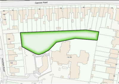
Location: Trinity Wildlife Garden (0.39 ha) lies on the boundary of the Trinity Place / Clarence Crescent CA. Accessed from the back of Clarence Rd Medical Centre carpark, off Vansittart Road (NCN4) due south of Clarence Rd/Vansittart Rd junction immediately NE of Vansittart Recreation Ground. |
|
Why is this space demonstrably special? |
1) Historic importance: This was originally part of an open field in the Ancient Manor of Clewer (Saxon) which pre-dates construction of Windsor Castle. The history of the allocation and development of the Trinity Wildlife Area (TWA) is recorded on a sign at the entrance to the site. 2) Natural habitats and wildlife: The grassy area and naturally occurring plants in this small Natural and Semi Natural (NSN) open space provide valuable support for biodiversity and form an important “link” in the local green infrastructure which includes private gardens, highways land, Amenity Green Space, allotments and the Vansittart Recreation Ground. A number of species of small birds, insects, bats and other urban woodland creatures depend on this site as a vital connection with these neighbouring natural habitats. TWA also provides a visual and environmental respite and air pollution “buffer” between neighbouring residential areas and areas of hardstanding (parking at the Clarence Road GP Surgery, public highway and footways). 3) Beauty, Tranquillity and Recreational value: The Wildlife Area was allocated and developed specifically to provide a quiet and protected space for biodiversity, relaxation and informal activities. |
|
Is the retention of this open space consistent with Borough Local Plan policies for sustainable development? |
Yes. It is listed in the RBWM Open Space Audit (2008), which suggests the local quantity standard for NSN Open Space provision should be slightly increased. Retention of this site is therefore consistent with BLP strategic and sustainable development objectives. |
Does this land have planning permission? |
No |
|
Does this land already benefit from protection, such as Green Belt, National Park, AONB, SSSI, Scheduled Monument or Conservation Area? |
Yes. The OSA (2008) lists this site as an NSN (ID 51, Analysis Area 2, Appendix F) on the boundary of the Trinity Place/Clarence Crescent Conservation Area. It has also been identified by the Borough in a study (2016) of potential “Pocket Parks” (OSA, section 4.48). |
Is it capable of enduring beyond the plan period? |
Yes |
Is this space in close proximity to the community it serves? |
Yes |
Is this space an extensive tract of land? |
No |
|
Is the space located within a new development and if so, how is it demonstrably special or of local significance? |
No |
|
Who is the landowner? Have they been consulted and, if so, what are their views on designation? |
RBWM (see notes above) |
How will the green space be managed in the future? |
This has previously been managed jointly by RBWM working with groups of local volunteers including nearby schools. |
|
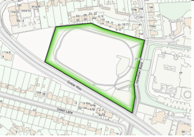
Location: Vansittart Recreation Ground is a roughly rectangular parcel of ground, about 2.5 hectares in area, between Goslar Way and the south end of Vansittart Road which is closed to motor traffic. There are access points from Vansittart Road where there is a small car park and off Goslar Way. Footpaths give access to Alma Road and under Goslar Way to Green Lane. |
|
Why is this space demonstrably special? |
The Recreation Ground was for many years the home of Windsor and Eton Athletics Club and was formed into a public park in 2000 after the Club moved out. There was a proposal by RBWM to develop the land for housing but this did not proceed, following a local campaign and the acknowledgement that this area of Windsor is deficient in public open space. As currently set out, the Recreation Ground consists of three areas: a dog-free central green space containing a children’s play area and kick about area, a dog walking track of 1000 paces round the outside and a purpose-built skate board park. There are a number of mature trees on the margins together with more recent tree, shrub and meadow planting. All parts of the park are very well used. One Sunday in spring 2016, for example, 30 youngsters were using the skate board park. Many people walk their dogs there as it is the only suitable green space for dog walking in the area. Families with children use the park regularly and walkers and joggers take exercise there. Residents cross the park to access local facilities. Recent meadow and tree planting has increased the diversity of wildlife habitats. The park is special to long-term residents who campaigned to save it in 1989. |
|
Is the retention of this open space consistent with the Borough Local Plan policies for sustainable development? |
Yes |
Does the land have planning permission? |
No |
|
Does this land already benefit from protection such as Green Belt, National Park, AONB, SSSI, Scheduled Monument or Conservation Area? |
Yes. Listed on RBWM website as a public park and listed as “local open space” in the RBWM Supplementary Planning Guidance document “Public Open Space Provision” 2003. |
Is it capable of enduring beyond the plan period? |
Yes |
Is this space in close proximity to the community it serves? |
Yes |
Is this space an extensive tract of land? |
No |
|
Is the space located within a new development and if so, how is it demonstrably special or of local significance? |
No |
|
Who is the landowner? Have they been consulted and, if so, what are their views on designation? |
RBWM |
How will the green space be managed in the future? |
RBWM |
|
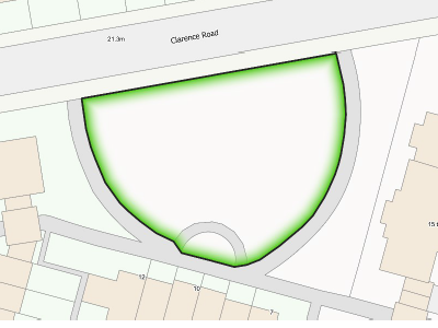
Location: This is at the front of the Trevelyan development immediately west of the Clarence Road Roundabout. |
|
Why is this space demonstrably special? |
1) Historic importance: This area was originally part of the Ancient Manor of Clewer (Saxon) which pre-dates construction of Windsor Castle. 2) Natural habitats and wildlife: Grass, shrubs and trees on-site provide important support for biodiversity. This is an important “link” in a network which stretches between the river to the north and Windsor Great Park to the south, and east–west routes which cross the Clarence Road Roundabout. A number of species of small birds, insects including Stag Beetles, bats and other creatures depend on this to provide a vital conduit within the local green infrastructure. 3) Beauty, Tranquillity and Recreational value: This provides a quiet, public open space for relaxation and informal activities in an area dominated by busy roads. It is also a pollution “buffer zone” and “green lung” near the Clarence Road Roundabout AQMA. (NB There are no sports facilities, or recreational equipment and buildings on this site.) |
|
Is the retention of this open space consistent with Borough Local Plan policies for sustainable development? |
Yes. The RBWM Open Space Audit 2008 (Local Plan Evidence Base) states that, 1.6 “Open space and recreation provision…has an important role to play in the implementation of…national objectives and…in the achievement of key Council priorities.” (Sec 1, p 1) 1.11 “Open spaces…provide a number of functions within the urban fabric of towns and villages. For example,…provision for play and informal recreation, a landscaping buffer within and between built environments and/or a habitat for the promotion of biodiversity.”
1.15 “Parks and open spaces are more accessible to a wider range of people than some sports and leisure facilities and are better able to realise the aims of social inclusion and equality of opportunity. The provision of open spaces and recreation is key to a sustainable and thriving community.” |
Does this land have planning permission? |
No. This is on-site public open space provided as part of S106 contributions for the residential development of the former Trevelyan School (2002). |
|
Does this land already benefit from protection such as Green Belt, National Park, AONB, SSSI, Scheduled Monument or Conservation Area? |
No (See comments above) |
Is it capable of enduring beyond the plan period? |
Yes |
Is this space in close proximity to the community it serves? |
Yes |
Is this space an extensive tract of land? |
No |
|
Is the space located within a new development and if so, how is it demonstrably special or of local significance? |
See comments above |
|
Who is the landowner? Have they been consulted and, if so, what are their views on designation? |
RBWM |
How will the green space be managed in the future? |
RBWM |
|
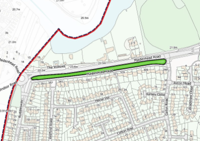
Location: This space is located on the south side of the A308 Maidenhead Road, between Ruddlesway and Gallys Road. There are two parts to this – a narrow strip parallel to the Maidenhead Road and a small square at the end of Redford Road. To the south of the space is the separate residential road having the “Maidenhead Road” address. |
|
Why is this space demonstrably special? |
This narrow strip provides a buffer to the traffic on Maidenhead Road in terms of noise, sight and pollution. This strip is in layers – working south from the main Maidenhead Road there is an asphalt path, a grass verge, a high and well established beech hedge with a wide variety of well-established trees growing through it, and finally grass. The asphalt footpath is rarely used, as pedestrians and cyclists use the quieter and safer minor Maidenhead Road abutting this green space. At the eastern end of this strip are well established trees and a sapling. This open strip complements the open front gardens of the houses on Maidenhead Road. The small square at the end of Frymley View is grassed, with well-established trees providing a green view from Frymley View. The minor Maidenhead Road can be accessed by vehicles from both the West and East ends, whilst there is pedestrian access to the east side of the Willows roundabout and footpaths to Frymley View and Hayse Hill. This Space provides a green route for Dedworth residents to access Sutherland Grange. |
Is the retention of this open space consistent with Borough Local Plan policies for sustainable development? |
Yes |
Does this land have planning permission? |
No |
Does this land already benefit from protection, such as Green Belt, National Park, AONB, SSSI, Scheduled Monument or Conservation Area? |
TBC. This area was not specifically listed within RBWM OSA. |
|
Belt, National Park, AONB, SSSI, Scheduled Monument or Conservation Area? |
2008, but may be covered by Item #125 Whiteley – see #21 above. |
Is it capable of enduring beyond the plan period? |
Yes |
Is this space in close proximity to the community it serves? |
Yes. To the south of this Space lie detached houses. |
Is this space an extensive tract of land? |
No |
|
Is the space located within a new development and if so, how is it demonstrably special or of local significance? |
No |
|
Who is the landowner? Have they been consulted and, if so, what are their views on designation? |
RBWM |
How will the green space be managed in the future? |
RBWM |
|
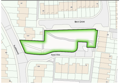
Location: This Amenity Green Space (AGS) is to the North of Reed Way, adjoining Birch Grove (56A). |
|
Why is this space demonstrably special? |
The space serves as a valuable and well-used “village green” for both the older and newer residential developments, which include a local shop and form the perimeter of this space. There are several mature trees covered by TPOs, as well as several saplings set in open grassland. A network of asphalt paths with street lighting connects this area with LGS 18 and forms part of an excellent network of rights of way, including a through route to the local First School. |
|
Is the retention of this open space consistent with Borough Local Plan policies for sustainable development? |
Yes. The Open Space Audit (2008) concluded there is already a shortfall in provision of AGS in Windsor. Both of these areas constitute valuable space for informal recreation, considered the more significant proportion (2.5 ha/1000 pop) of the RBWM adopted public open space standard (4.3 ha/1000 pop). |
Does this land have planning permission? |
No |
|
Does this land already benefit from protection, such as Green Belt, National Park, AONB, SSSI, Scheduled Monument or Conservation Area? |
No, save only for Tree Preservation Orders (TPOs) |
Is it capable of enduring beyond the plan period? |
Yes |
|
Is this space in close proximity to the community it serves? |
Yes. The two areas are surrounded on all sides by residential properties and adjoining residential roads. These areas are connected by a network of paths and rights of way which run through the surrounding estate, providing a safe route to the local First School and good general pedestrian access throughout. |
Is this space an extensive tract of land? |
No |
|
Is the space located within a new development and if so, how is it demonstrably special or of local significance? |
Yes. See above. |
|
Who is the landowner? Have they been consulted and, if so, what are their views on designation? |
RBWM |
How will the green space be managed in the future? |
RBWM |
|
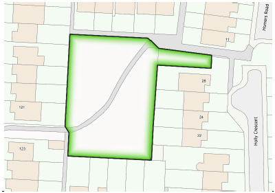
Location: This space is to the South of Reed Way with access by footpath from Reed Way and Holly Crescent. Access is also possible via footpath between 121 & 123 Ruddlesway (56B). |
|
Why is this space demonstrably special? |
The space provides a valuable Local Area of Play (LAP) for children. It is bounded on all sides by rear garden fences and gates. It is surfaced entirely by grass and children are able to play on the TPO mature trees. Saplings have been recently planted which extend this small woodland (“spinney”) sympathetically, in keeping with other such natural and semi-natural spaces (NSNs) characteristic of the historical Saxon Manor of Dedworth. These additional trees enhance the visual amenity, provide support for biodiversity and give a “sense of place” along this attractive walking route. A dog waste litter bin is provided to ensure the area is kept tidy. A network of asphalt paths with street lighting connects this area with LGS 17 and forms part of an excellent network of rights of way, including a through route to the local First School. |
|
Is the retention of this open space consistent with Borough Local Plan policies for sustainable development? |
Yes. The Open Space Audit (2008) concluded there is already a shortfall in provision of AGS in Windsor. Both of these areas constitute valuable space for informal recreation, considered the more significant proportion (2.5 ha/1000 pop) of the RBWM adopted public open space standard (4.3 ha/1000 pop). |
Does this land have planning permission? |
No |
|
Does this land already benefit from protection, such as Green Belt, National Park, AONB, SSSI, Scheduled Monument or Conservation Area? |
No, save only for Tree Preservation Orders (TPOs) |
Is it capable of enduring beyond the plan period? |
Yes |
Is this space in close proximity to the community it serves? |
Yes. The two areas are surrounded on all sides by residential properties and adjoining residential roads. These areas are connected by a network of paths and rights of way which run through the surrounding estate, providing a safe route to the local First School and good general pedestrian access throughout. |
Is this space an extensive tract of land? |
No |
Is the space located within a new development and if so, how is it demonstrably special or of local significance? |
Yes (See above) |
Who is the landowner? Have they been consulted and, if so, what are their views on designation? |
RBWM |
How will the green space be managed in the future? |
RBWM |
|
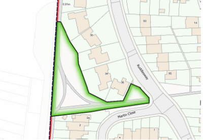
Location: This NSN and AGS is a triangle of green space located on the western side of the Laing Estate. It lies on the Willows Path (which connects Maidenhead Road to Dedworth Road) and immediately to the rear of Nos. 28–36 Ruddlesway. A public footpath and green verge connect to Ruddlesway. |
|
Why is this space demonstrably special? |
It is a vestige of the ancient Manor of Dedworth (Saxon). In recent times, it was left as AGS when the Laing Estate was developed. Adjoining the PROW (also known as The Willows Path) and crossed by two footways linking it to Ruddlesway, this space is very well used by residents including dog-owners for walking and relaxation, and by children as a local area of play (LAP). Various hedgerow shrubs grow along the boundaries of the space and two mature willow trees stand near its centre. These combine to form an NSN area near the mid-point of the 700-yard Willows Path (see WNP Policy BIO.02 Green Routes) and the whole provides an important biodiversity “link” with residential gardens, verges to the north and south of the Willows Path, the Willows Path itself, and fields to the west. Note: A number of local place names are derived from “The Willows”, the former home of the Duchess of Sutherland, situated on the banks of the Thames. It comprised a substantial house, woodlands, and extensive grounds now largely given over to Sutherland Grange Nature Reserve. |
Is the retention of this open space consistent with Borough Local Plan policies for sustainable development? |
Yes. The OSA (2008) states that such AGS sites “provide a key contribution to the landscape and setting” (para 6.3) of residential areas. The OSA concluded there is already a shortfall in the provision of Amenity Green Space in Windsor and levels should be increased to meet a local recommended quantity standard of 0.59 ha per 1000 pop (para 6.9). As well as providing important visual amenity, spatial respite, and biodiversity support within the residential area, the trees, shrubs, and grass form an important ‘green lung’between neighbouring houses and adjacent busy urban roads. The OSA also states that, “The value placed on natural and semi natural open space is clear, both in terms of the recreational resource these spaces offer and the role that natural areas play in biodiversity and conservation. …… all other consultations emphasised the protection of existing provision ……”. The OSA recommended an increase in provision of NSNs from 5.31 ha to 5.4 ha per 1000. (para 5.10) |
Does this land have planning permission? |
No |
Does this land already benefit from protection, such as Green Belt, National Park, AONB, SSSI, Scheduled Monument or Conservation Area? |
No |
Is it capable of enduring beyond the plan period? |
Yes |
Is this space in close proximity to the community it serves? |
Yes. This space is bordered by the Willows Path, Ruddlesway and Martin Close residential roads. It is also close to the Willows Caravan Park site, the Broom Farm and Limes Estates and the wider West Windsor area. |
Is this space an extensive tract of land? |
No |
Is the space located within a new development and if so, how is it demonstrably special or of local significance? |
No. This space was deliberately left as an important open space when the estate was set out. |
Who is the landowner? Have they been consulted and, if so, what are their views on designation? |
RBWM |
How will the green space be managed in the future? |
RBWM |
|
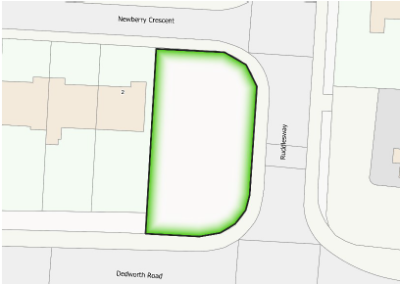
Location: This area is on the NW corner of the junction of Dedworth Road and Ruddlesway (southern end), occupying open land between Dedworth Road and the entrance to Newberry Crescent. |
|
Why is this space demonstrably special? |
This Amenity Green Space (AGS) is a local landmark, containing four mature trees of different species set in continuous lawn. In the extensive residential road network to the north and the Fairacres Industrial Estate to the south, it helps to preserve a valuable sense of environmental openness and attractive visual amenity characteristic of the Laing Estate. It also provides an important biodiversity “link” with residential gardens, verges and the Willows Path. |
Is the retention of this open space consistent with Borough Local Plan policies for sustainable development? |
Yes. The Open Space Audit (2008) states that such spaces “provide a key contribution to the landscape and setting” (para 6.3) of residential areas. The OSA concluded there was already a shortfall in the provision of Amenity Green Space in Windsor and that levels should be increased to meet a local recommended quantity standard of 0.59 ha per 1000 pop (p.80). As well as providing visual respite and biodiversity support, the combination of trees and grass forms an important “green lung” between neighbouring houses and the adjacent busy urban junction. These considerations confirm that retention of this space is consistent with the BLP’s sustainable development objectives. |
Does this land have planning permission? |
No |
Does this land already benefit from protection, such as Green Belt, National Park, AONB, SSSI, Scheduled Monument or Conservation Area? |
No |
Is it capable of enduring beyond the plan period? |
Yes |
Is this space in close proximity to the community it serves? |
Yes. The area is surrounded by residential properties and by a thriving industrial estate. |
Is this space an extensive tract of land? |
No |
Is the space located within a new development and if so, how is it demonstrably special or of local significance? |
No. This space was left deliberately as open space when Newberry Crescent was developed, providing important environmental amenity and creating an identifiable local landmark. |
Who is the landowner? Have they been consulted and, if so, what are their views on designation? |
RBWM |
How will the green space be managed in the future? |
RBWM |
|
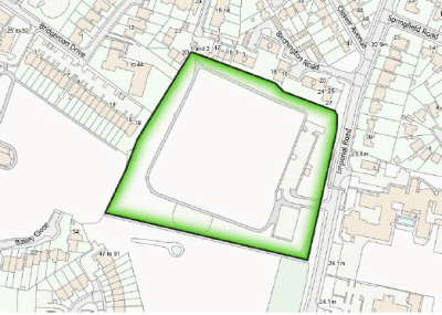
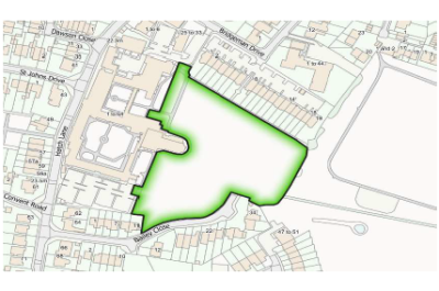
Location: Convent Park is located behind the Convent Court, Grey Court and Cloisters residential developments (formerly the Convent of St. John the Baptist, Chapel and grounds) between Bridgeman Drive, Hatch Lane and the back of Imperial Park. Access is from Bridgeman Drive, off Hatch Lane. |
|
Why is this space demonstrably special? |
1) Historic importance: Part of the Ancient Manor of Clewer (Saxon) which pre-dates construction of Windsor Castle, the area in which the Park is located originally fell within the curtilage of an early medieval manor building and subsequent 19th-century revision, Clewer Manor (House, Grade II), occupied by generations of owners of the Manor of Clewer dating back to at least the 12th century. The 1817 enclosure award in Clewer saw the park site become separately owned, on which a large house, Nightingale Lodge, was erected. The Lodge was purchased some years later by Mrs. Mariquita Tennant and Rev. T. T. Carter in order to expand their rescue work helping impoverished residents in Clewer Parish. The scale of these efforts gradually outstripped the size of the building, however, and it was torn down to make way for the construction of the Convent of St. John the Baptist, commencing in 1851. The Convent was redeveloped for housing in 2002 and a condition of planning permission was the creation of Convent Park in order to increase provision of informal public open space in the area and preserve the setting of the listed Convent (Grade II) and Main Chapel (Grade II*). 2) Natural habitats and wildlife:
With its ancient “Water Meadow” and grassland, overground and underground streams, mature specimen trees, historic orchard and hedges, the Park is an important remnant of the meadows and orchards which covered this part of Windsor and provides crucial support for biodiversity. Notably, in the UK, more priority species for conservation are associated with grasslands than with any other habitat type. A wide variety of wildlife is supported by this environment — a combination of protected
species (e.g. Stag Beetles, Pipistrelle Bats) and other wild creatures including owls, many small birds, woodpeckers, foxes and deer living in Windsor Forest and Clewer Wood, which included this area, together with animals and birds introduced by successive owners of the Clewer Manor House. Pheasants and partridges continue to thrive in the present day and are still 3) Beauty, Tranquillity and Recreational value: The Park was created specifically to provide quiet public open space for relaxation and informal activities, including dogwalking. Its tranquillity and beauty reflects the long, evolving history of the Manor and the Convent. |
Is the retention of this open space consistent with Borough Local Plan policies for sustainable development? |
Yes. The RBWM Open Space Audit (2008) states that: 1.6 “Open space and recreation provision... has an important role to play in the implementation of national objectives and in the achievement of key Council priorities.”(Sec 1, p 1) 1.11 “Open spaces provide a number of functions within the urban fabric of towns and villages. For example, provision for play and informal recreation, a landscaping buffer within and between built environments and/or a habitat for the promotion of biodiversity.”(Sec 1, p 2) 1.15 “Parks and open spaces are more accessible to a wider range of people than some sports and leisure facilities and are better able to realise the aims of social inclusion and equality of opportunity. The provision of open spaces and recreation is key to a sustainable and thriving community.”(Sec 1, p 2) |
Does this land have planning permission? |
No |
Does this land already benefit from protection, such as Green Belt, National Park, AONB, SSSI, Scheduled Monument or Conservation Area? |
Yes. It forms the setting of two listed buildings, is adjacent to two other listed buildings (Clewer Manor and Recognition House), and has close historic associations with the nearby Mill Lane Conservation Area. |
Is it capable of enduring beyond the plan period? |
Yes |
Is this space in close proximity to the community it serves? |
Yes |
Is this space an extensive tract of land? |
No |
Is the space located within a new development and if so, how is it demonstrably special or of local significance? |
No. Within an existing development (2002). See comments above. |
Who is the landowner? Have they been consulted and, if so, what are their views on designation? |
Privately owned. |
How will the green space be managed in the future? |
The management of the open space is the responsibility of the owner. |
< Previous | ^ Top | Next >