
6.1 The community of Old Windsor and the surrounding areas are highly susceptible to flooding. The majority of its 5,000 residents live in approximately 2,000 properties alongside the River Thames. The residential area is low lying with most of the area being defined by the Environment Agency as Fluvial Zone 2 (medium probability) and Zone 3 (high probability) flood zones.
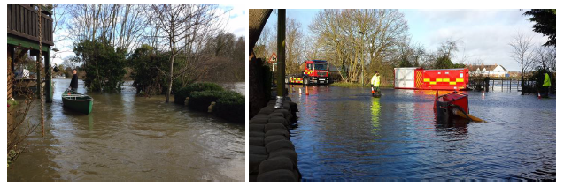
6.2 Recent history has highlighted the extent of the flood threat that the community lives with. In February 2014, Old Windsor experienced widespread flooding which left a number homes and businesses damaged (see pictures below and Figure 6.1). More recently, ground and surface water flooding has continued to blight the lives of residents (see pictures at bottom of page).
Flooding in Old Windsor, February 2014
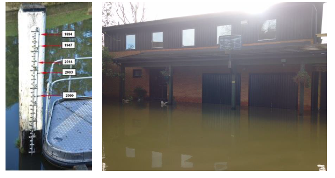
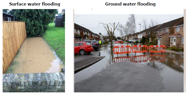
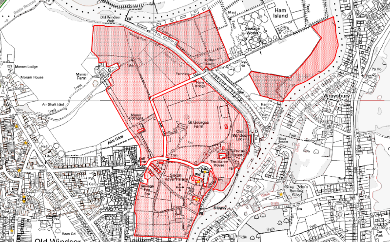
Figure 6.1: Extent of flooding from 2014 floods
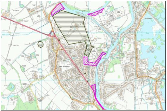
Key: Green hatching = groundwater flooding; Pink hatching = surface water flooding
Source: Old Windsor Parish Council/Parish Online
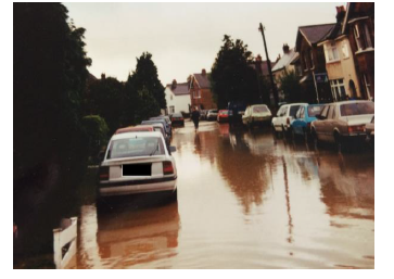
6.3 As the photograph below shows from floods in 1993, this threat has not been properly addressed yet serious flood events are becoming increasingly prevalent.
6.4 The Battle Bourne Embankment (a flood alleviation scheme) only protects up to the 1-in-75-year flood event. In 2014, water levels over-topped this and demonstrated that the system was not able to deal with a 1-in-100-year flood event. Between 1847 and 2000, a total of three major (1-in-100-year) flood events were recorded. Since 2000, a further three major flood events have occurred. Such floods are clearly no longer 1-in-100-year events yet the existing infrastructure will not adequately mitigate the impact.
Flooding in Old Windsor in 1993
6.5 The threat of flood from the River Thames, coupled with the limited capacity of the sewerage and drainage systems to cope with extreme events is going to increase the likelihood of such events over the plan period.
6.6 This issue, more than any other, was put forward by the community of Old Windsor as being of significant concern. Alongside these major flood events, the community regularly experiences flooding across the whole of the built-up area, as evidenced by the number of incidents logged with RBWM.
6.7 Without appropriate mitigation strategies and robust design to ensure that new development uses all techniques available to minimise waste water that flows into the system, then every new building will increase the pressure on a system which is already unable to cope in extreme events. It is imperative that all new development does everything that is possible can to actively reduce flood risk in Old Windsor.
6.8 The NPPF states at paragraph 163 that, when determining planning applications, local planning authorities should,
“…ensure flood risk is not increased elsewhere. Where appropriate, applications should be supported by a site-specific flood-risk assessment. Development should only be allowed in areas at risk of flooding where, in light of this assessment (and the sequential and exception tests, as applicable) it can be demonstrated that:
6.9 The 2014 Royal Borough of Windsor and Maidenhead Strategic Flood Risk Assessment (SFRA)3 is a high-level report that covers the whole borough. It properly identifies the risks in general but does not separately identify the issues for Old Windsor parish. It states that, “A considerable proportion of the Royal Borough of Windsor and Maidenhead is at risk from flooding.” It then clarifies that:
“The risk of flooding posed to properties within the Borough arises from a number of sources including river flooding, localised runoff, sewer and groundwater flooding.” (paragraph 37)
6.10 The SFRA does note the importance of taking a proactive approach to the reduction of flood risk and minimising localised flooding issues. It recommends that:
“Developers will be expected to demonstrate that their proposal will deliver a reduction in flood risk to the Borough, whether that be by reducing the frequency or severity of flooding (for example, through the introduction of SuDS), or by reducing the impact that flooding may have on the community (for example, through a reduction in the number of people within the site that may be at risk)” (Executive Summary, para. 35)
6.11 The SFRA recommends a series of risk reduction measures including:
Flooding in Old Windsor, February 2014
6.12 The SFRA was published prior to the storm events of February 2014 which highlights the importance of action.
6.13 The 2014 RBWM Local Flood Risk Management Strategy4 considers the various causes of flooding, prevention strategies and RBWM’s statutory responsibility as Lead Local Flood Authority, to cooperate and work with a range of other bodies, including parish councils, to prevent and manage flooding. It outlines a series of objectives that include the reduction of existing flood risk and ensuring that land use planning avoids, minimises and prevents an increase in flood risk. In addition, as noted by Thames Water in its Regulation 16 response to the submission version of the Neighbourhood Plan, it is likely that need will arise for additional water and/or sewerage infrastructure over the life of in-flood risk areas.
6.14 The SFRA notes at paragraph 39:
“A planning solution to flood risk management should be sought wherever possible, steering vulnerable development away from areas affected by flooding in accordance with the NPPF Sequential Test.”
6.15 As part of the preparation of the Neighbourhood Plan, extensive engagement has been undertaken with the Environment Agency to identify specific problems and locations where, if needed, flood barriers could be installed. Such schemes need to provide a permanent solution.
6.16 It is therefore considered important that any new built development properly addresses the threat of flood risk and ensures, through good design, that it is capable of contributing towards the reduction of overall flood risk and can adapt the challenges posed by climate change. This can be done in a variety of ways, including the use of SUDS but also measures to retain water on site (both rain and grey water) to allow its reuse or subsequent release when peak flows diminish. Good design should incorporate such systems into new development.
6.17 The SFRA notes that the appropriate application of a SUDS scheme to a specific development is heavily dependent upon the topography and geology of the site (and its surrounds). Careful consideration of the site characteristics must therefore be given to ensure the future sustainability of the adopted drainage system. Thames Water notes that it is the responsibility of a developer to make proper provision for surface water drainage to groundwater courses or surface water sewers. It must not be allowed to drain to the foul sewer, as this is the major contributor to sewer flooding.
6.18 In addition, it is important that the success of individual measures is monitored in order that optimum solutions can be incorporated into developments. There are examples from areas with similar geologies to Old Windsor (clay soils with a high water table) where SUDS has not been particularly successful.
6.19 For residential extensions requiring planning permission, this requirement will only be expected where additional bedrooms or bathrooms are being built on an existing property, i.e. it will not be required for extensions which are simply providing additional living space (kitchens, living rooms, etc).
POLICY OW5: FLOODING AND DRAINAGE
New development should be designed to take full account of any existing flood risk, irrespective of the source of flooding. Where a site or its immediate surroundings have been identified to be at flood risk, all opportunities to reduce the identified risk should be investigated at the master planning stage of design and subsequently incorporated at the detailed design stage.
It is essential that the drainage scheme proposed to support new development:
Planning permission should only be granted for new development subject to a condition that:
This shall apply to all built development for active use with the exception of residential extensions which do not propose additional bedrooms and/or bathrooms.
POLICY OW6: SUDS DESIGN AND MANAGEMENT
In line with NPPF paragraph 163, surface water drainage on any development must not add to the existing site run off or cause any adverse impact to neighbouring properties or the surrounding environment/wildlife habitat.
Development proposals creating new drainage requirements must demonstrate that Sustainable Drainage Systems (SUDS) will be effective and incorporated in any proposed developments. This should allow for above surface water management on site taking account of the underlying geology and seasonally high ground water table affecting parts of Old Windsor.
Any drainage scheme must manage all sources of surface water, including exceedance flows and surface flows from offsite, provide for emergency ingress and egress and ensure adequate connectivity.
Development proposals should be supported by a drainage scheme maintenance plan which demonstrates a schedule of activities, access points, outfalls and any biodiversity considerations. The maintenance plan should also include an indication of the adopting or maintaining authority or organisation and may require inclusion within a register of drainage features.
6.20 The community of Old Windsor is acutely aware through experience that there are issues relating to waste water capacity and how that is managed during storm events.
6.21 The flooding events of February 2014 did not only cause problems for residential and commercial properties, they also appear to have affected the Windsor Sewage Treatment Works (STW), located on Ham Island. It is believed that the land treatment area (locally known as the storm lagoons) were in operation and may have been full during this period. Some weeks after river levels had fallen, the storm lagoons still appeared to be full and were holding water for extended periods of time. This resulted in a strong odour being released for a long period of time into the summer of 2014.
6.22 Unfortunately, due to equipment failure, Thames Water (the sewerage provider/authority) was unable to collect data on the number of times that storm flow exceeded capacity of both the STW and the storm lagoons and the volumes of untreated sewage that were discharged into the river. Data was made available however from July 2014 to July 2015.
6.23 Old Windsor Parish Council commissioned a technical study5 to review this data, to better understand these issues and to inform the Neighbourhood Plan. This study concluded that there is an issue with capacity at the Windsor STW and that development should be restricted in Old Windsor until such time as this is resolved. In its supporting letter to the study, the authors identified that Thames Water can introduce measures to increase capacity, including increasing storm tank capacity on site, and also increase the processing capacity of the plant as there is some headroom available in the discharge consent.
6.24 This demonstrates that the Windsor STW is operating at capacity. Additional development will put further pressure on this and, over the plan period, it is considered necessary that the STW will require expansion. There is capacity at Ham Island for expansion of the Windsor STW and any development needs to be in line with the Thames Water Process Capacity Plans through to 2036. One issue that will need to be resolved is the capacity of the Ham Island Bridge to accommodate heavy goods vehicular traffic. This is addressed in Non-Policy Action 2.
6.25 This work has enabled an ongoing and positive dialogue to be opened up and sharing of further data to occur between the Parish Council and Thames Water. This dialogue and data sharing has confirmed that that, if further development is to be enabled in Old Windsor then:
6.26 Thames Water continues to encourage developers to consider water and wastewater holistically through the preparation of integrated water and wastewater strategies early on in the planning process. These strategies provide a focus for designing sustainable water and wastewater infrastructure at a strategic, communal and individual project level.
6.27 It is considered important and necessary that such an approach is supported with appropriate planning policy. Where appropriate, planning permission for development resulting in the need for off-site upgrades, may be subject to a planning condition to ensure that first occupation is prohibited prior to the completion of necessary infrastructure upgrades.
6.28 Developers are encouraged to contact the water/waste water management organisation as early as possible to discuss their development proposals and intended delivery programme to assist with identifying any potential water and wastewater network reinforcement requirements. Where there is a capacity constraint planning permission may be subject to a phasing condition requiring completion of necessary infrastructure upgrades prior to first occupation of the relevant phase of development.
6.29 A further issue of relevance is that two large areas of Ham Island are covered by a Scheduled Monument, this being the early medieval and medieval palace of Kingsbury, a site of national importance. This is shown on Figure 6.2.
Figure 6.2: Extent of the Kingsbury Scheduled Monument
Source: Berkshire Archaeology
6.30 In addition, work by archaeology consultants to inform the Neighbourhood Plan6 has established that there is a high potential for prehistoric archaeology on Ham Island. This was evidenced by excavations at the STW itself.
6.31 The NPPF states at paragraph 193 that:
“When considering the impact of a proposed development on the significance of a designated heritage asset, great weight should be given to the asset’s conservation (and the more important the asset, the greater the weight should be)”
6.32 As a scheduled monument, it is of the highest significance and any harm or loss should require clear and convincing justification, with substantial harm or loss being wholly exceptional.
POLICY OW7: SEWERAGE DISPOSAL AND WINDSOR SEWAGE TREATMENT WORKS
Development will be supported if the sewer network can accommodate the additional demand for sewerage disposal, both from the development itself and from permitted developments in the area where this can be accommodated within the sewer network, either in its existing form or through planned improvements to the system, in advance of the construction or occupation of the development.
Developers should be encouraged to engage with the appropriate water resources management organisation at the earliest opportunity, as indicated in paragraph 26 of the NPPF (February 2019), (or subsequent updates) to evaluate:
The expansion of Windsor Sewage Treatment Works will be supported if the development does not cause harm to the significance of the Kingsbury Scheduled Monument or other archaeological remains (which might be either directly or by being within their setting) unless such harm is shown to be unavoidable, has been minimised or mitigated, and is justified by being outweighed by the public benefits of the development.
6.33 Whilst the STW is operating at capacity, it is important that appropriate conditions are placed upon any new development in respect of the volume of additional sewage that is discharged to the STW.
6.34 Developers should be required to demonstrate in their planning application submission that there is adequate infrastructure capacity both on and off the site to serve the development and that it would not lead to adverse amenity impacts for existing or future users. Developers are strongly advised to liaise with Thames Water ahead of submission of any planning application.
6.35 However, the Water Industries Act 1991 effectively makes it impossible for Thames Water to object or for RBWM to refuse to grant planning permission for development on the grounds that no improvement works are planned for a particular area. The Act specifically requires Thames Water to accommodate the development whatever the circumstances.
6.36 It is therefore necessary for RBWM to make any planning permission conditional upon the sewerage authority first taking any steps necessary to ensure that the public sewer will be able to cope with the increased load. This is secured through the use of ‘Grampian’ style planning conditions. RBWM will then determine any details submitted pursuant to such conditions in accordance with any views expressed by Thames Water. Such conditions would commonly be worded broadly as follows:
‘No dwelling hereby permitted shall be occupied until works to improve the existing public foul sewerage network so that it is able to cope with the flows from the proposed development have been completed.’
6.37 The use of Grampian-style planning conditions are considered to be vital in Old Windsor, given the limited capacity of the Windsor STW. Their use by RBWM is therefore welcomed. In order to inform the justification and application of such conditions, Old Windsor Parish Council will continue to work with Thames Water and RBWM to review the capacity of the STW and assess whether applications, on an individual basis, require such a condition. This is not a policy matter but a non-policy action.
NON-POLICY ACTION 1: USE OF GRAMPIAN-STYLE CONDITIONS
Old Windsor Parish Council will work with Thames Water and RBWM to understand the capacity of the Windsor STW and the need to use Grampian-style planning conditions in respect of any planning application for built development.
6.38 A separate but related matter is the accessway to Windsor STW. Currently the only access to the STW is across the Ham Island Bridge which is under the control of Thames Water. This bridge has a weight limit on it of 7.5 tonnes for most traffic. A recent study undertaken on behalf of Thames Water has assessed that the bridge is capable of sustaining 7.5-tonne general highway vehicles and specific authorised vehicles (which access the bridge less frequently) of up to 13 tonnes. The study also recommended that the bridge is strengthened/refurbished in order that the weight limits can be increased and Thames Water can access its facility with no restriction on its operational vehicles as well as providing unrestricted access for the public.
Ham Island Bridge
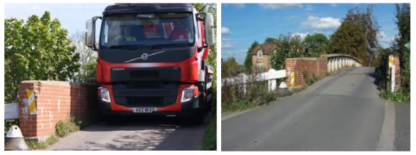
6.39 This work has been undertaken in late-2016 and the bridge is now able to accommodate the necessary traffic that will use the Windsor STW or be used to construct any development pertaining to its expansion.
6.40 In addition, the roadway leading to Ham Island (Ham Lane), used by both Thames Water and residents alike, is unadopted so is a shared accessway. HGV traffic which most commonly is using this roadway to access the STW on behalf of Thames Water, is causing damage to this road yet there is no responsibility on any party to maintain this. There is concern that the roadway could become unsafe for all users. Its upgrade is therefore supported. This roadway is bounded on both sides to the west of New Cut by the Kingsbury Scheduled Ancient Monument therefore it is likely that the archaeological interest extends under the roadway. Accordingly any proposals for its upgrading would need to be assessed for their likely effect on the Scheduled Ancient Monument, as would any proposals for landscaping, including tree planting either side of the bridge.
NON-POLICY ACTION 2: VEHICULAR ACCESS TO WINDSOR SEWAGE TREATMENT WORKS VIA HAM ALNE
Recognising the increase in development activity within the catchment area of the Windsor STW, Old Windsor Parish Council will monitor the levels of vehicular access and quality of the road surface along Ham Lane. If necessary, the Parish Council will then lobby RBWM to maintain the roadway to ensure that the needs of the increased volume and weight of traffic can be supported by the roadway.
6.41 The community, particularly those living on Ham Island, have identified a series of actions that it believes will help to improve the operation of the sewage treatment works whilst at the same time protecting the amenity of the existing residents and preserving the integrity of Ham Island as an historical landscape. These are:
3 Royal Borough of Windsor & Maidenhead (2014) Strategic Flood Risk Assessment (Level 1 SFRA)
4 Royal Borough of Windsor & Maidenhead (2014) Local Flood Risk Management Strategy
5 Stillwell Partnership (2015) Neighbourhood Plan: Drainage Issues within the Parish, for Old Windsor Parish Council
6 Berkshire Archaeology (2015) Archaeology in Old Windsor – a brief appraisal, for Old Windsor Parish Council
< Previous | ^ Top | Next >