
“…a rather sweet and agreeable place.”
The Road to Little Dribbling by Bill Bryson (2015)
The villages of Horton and Wraysbury lie in the central part of the Thames Valley on a broad, flat floodplain east of the River Thames and between Windsor to the West and Heathrow to the East. The parishes have developed from farming settlements and have grown over time as people migrated from London.
Horton dates back to the Domesday Book of 1086, listed as ‘Hortune’. A number of historical landmarks include The Old Rectory, Horton Lodge, The Cedars, Brookfield, Milton’s Cottage and St Michael’s Church. It has been recorded that a foundry located at the end of Coppermill Road was the source for the copper that made the famous Copper Horse at the end of the Long Walk from Windsor Castle. A number of historical houses can still be found in the village, including the Grade II listed Old Rectory, believed to have been built at the end of the 16th Century / early 17th Century.
Perhaps the most significant landmark today is the 12th Century church of St Michael’s, with its Norman arch over the north door. Indeed, the name most associated with the village is that of poet John Milton (1608–74), whose family rented Berkyn Manor, a house that belonged to Sir John Egerton between 1632 and 1640. Milton wrote many of the literary greats, including Comus, Il Penseroso and L’Allegro, whilst living in Horton. The chancel of St Michael’s also contains the grave of Milton’s mother Sara, and a 19th Century stained glass window which commemorates Milton’s poem Paradise Lost.
Through the Horton parish flows the Colne Brook which runs to the Thames from the River Colne.
Wraysbury is also mentioned in the Domesday Book and has a rich and ancient history, with many links to royalty. In Saxon times it was the hunting ground of kings, and in 1313 Wraysbury, administered as a Royal Manor, was given to Queen Isabella by Edward II and then assigned in Dower to the Queens of England under subsequent kings. The sealing of the Magna Carta by King John on 15th June 1215 is considered to have occurred on or near the north bank of the Thames within the Ankerwycke estate. In the grounds of Ankerwycke there are extensive remains of the 12th Century Benedictine nunnery, including the Priory ruins (Grade II listed) where it is considered King John would have held his base before meeting the barons. Nearby is the ancient yew tree, believed to be more than 2500 years old, and where legend has it that King Henry VIII courted Anne Boleyn.
Wraysbury’s settlement pattern is strongly influenced by its historic village core, comprising the Church of St Andrew, The George Inn (c. 16th century) and a triangular village green. The London & South Western Railway branch opened a line to Windsor in 1849, with stations at Wraysbury, Sunnymeads and Datchet. As a result, the settlement expanded as a linear settlement along roads stemming from The Green, including a Victorian Village focused on the High Street.
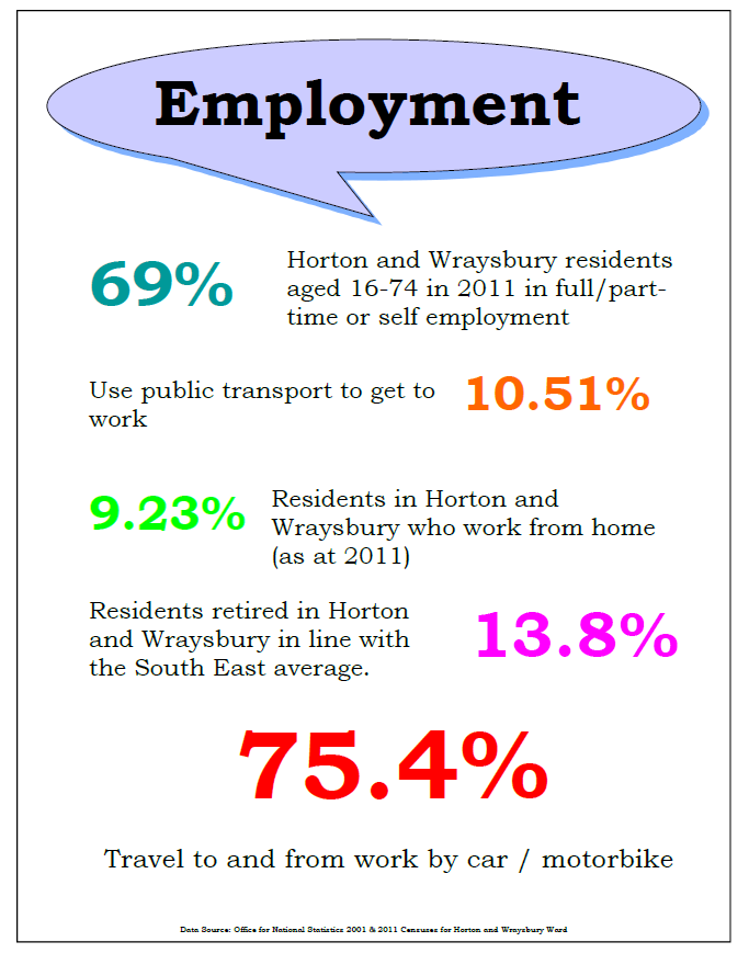
For centuries, agricultural and mill work had been the principal areas of employment for the villagers; as late as 1831, census results show that more than half of the 135 families in the village, 62 were employed in agriculture while 68 made their living in the mills.
The village experienced its greatest growth rate post-war (1939 onwards). Residential development spread along Welley Road, linking Wraysbury with Sunnymeads village. The majority of modern housing has spread westwards to the River Thames, comprising spacious ‘leafy’ suburbs.
The agricultural floodplain that once lay between Horton and Wraysbury was mined for gravel during the post-war period and later filled with water, forming large artificial water storage reservoirs, which result in restricting expansion of development. This network of mature gravel pits is now used as lakes for emergency water supplies and recreational purposes; mainly angling, sailing and bird watching.
Both Horton and Wraysbury were transferred from Buckinghamshire to Berkshire in 1974.
Horton and Wraysbury is the most easterly ward in the Royal Borough of Windsor & Maidenhead (RBWM). In the ward, a significant percentage of the land is within the Green Belt and the Flood Plain. The majority of our area is agricultural space and water, including the Queen Mother Reservoir and numerous gravel pits, with several areas of lake-land designated as SSSIs. The ward sits at the southern end of the Colne Valley Regional Park.
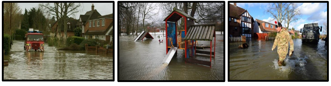
The western part of Wraysbury, roughly between the Thames and the B376 road, has experienced significant flooding, notably in January 2003, and January and February 2014. Yet despite the flooding risk, it remains a popular area in which to live.
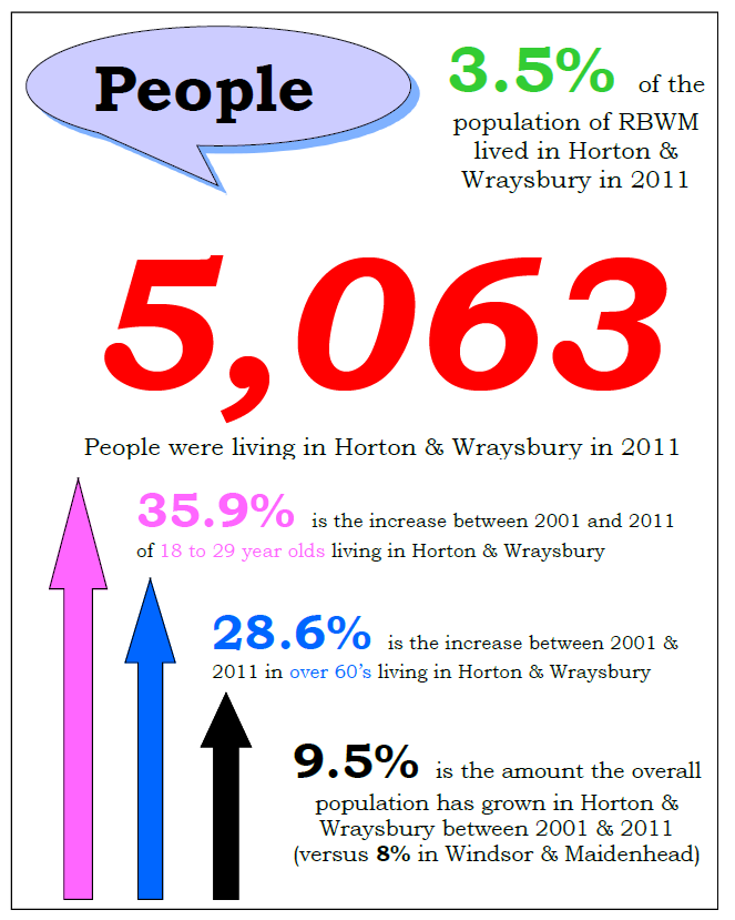
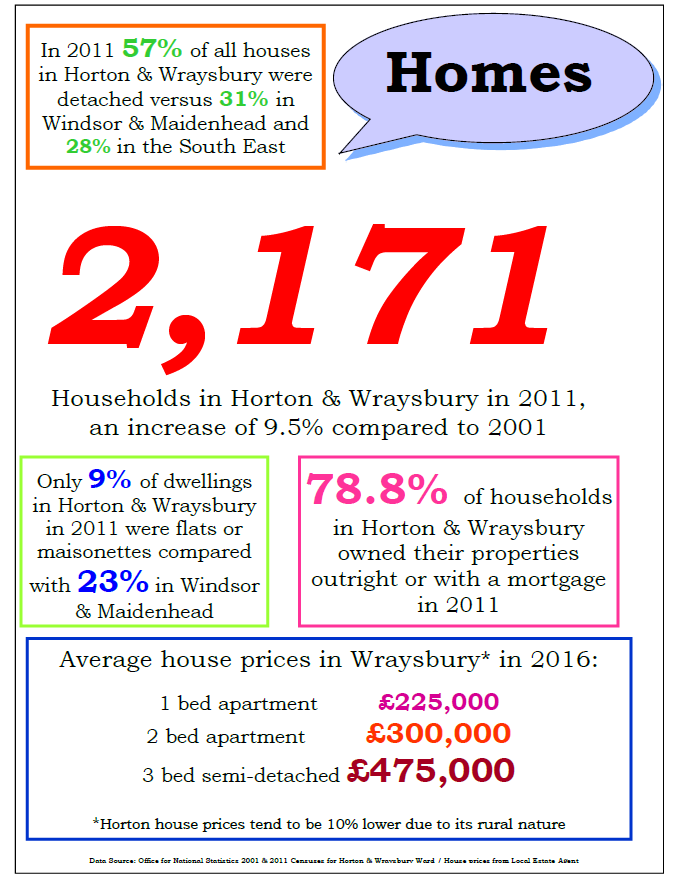
The population has grown by more than nine per cent from 2001 to 2011 and the ward is now a culturally diverse community.
Horton and Wraysbury have a variety of local shops, a Community Pharmacy, Post Office, four public houses and various other businesses. With village halls, sports and social organisations and three churches, it is a vibrant community. The neighbourhood is served by Wraysbury Primary School with multiple options for secondary schooling.
The nearest doctors’ surgery is now in neighbouring Datchet – the Wraysbury surgery having closed down. There are issues in getting the elderly, families and those who do not drive to the surgery.
Horton and Wraysbury are served by two railway stations on the Windsor & Eton Riverside to Waterloo line. There are two bus services covering Windsor (via Slough), Heathrow & Staines. The villages are close to the M25 / M4 / M3 motorways.
The network of lakes between Horton and Wraysbury are disused gravel pits which are now used for leisure pursuits. They form private fishing lakes, sailing clubs and a dive centre. There is an intention for some of the current working sites to be returned to agricultural use. Most of the lakes benefit from designation as Sites of Special Scientific Interest (SSSI), SW London Water Bodies Special Protected Areas (SPAs) or have European Ramsar protection as the landscape is colonised by a variety of birds and wildlife habitats.
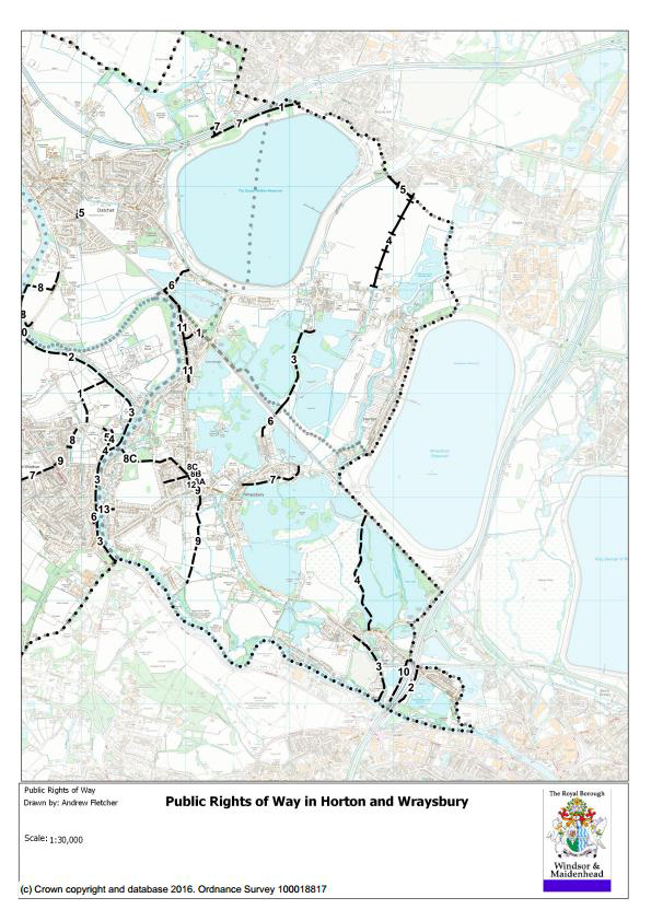
There are a number of existing public footpaths as shown on the following map, whilst over time other paths have developed as locals regularly use them for access, recreational walking and bird watching. There are also various proposed footpaths currently being considered by RBWM.
(See https://www3.rbwm.gov.uk/download/downloads/id/2136/prow_management_and_improvement_plan_map_6.pdf)
Horton and Wraysbury Neighbourhood Plan
Referendum Version November 2019
Horton and Wraysbury Neighbourhood Plan
Referendum Version November 2019
Horton and Wraysbury Neighbourhood Plan
Referendum Version November 2019
Horton and Wraysbury Neighbourhood Plan
Referendum Version November 2019
The Neighbourhood Plan recognises the challenges that face the community of Horton and Wraysbury Parishes. In summary, these challenges are:
Below is a brief summary of the consultation activities undertaken by the Horton and Wraysbury Neighbourhood Planning Group. A comprehensive Consultation Statement will be submitted alongside the Neighbourhood Plan, providing details of how we consulted the public, who we consulted (including any statutory consultees), a summary of main issues raised, and how we have addressed those issues in our Neighbourhood Plan.
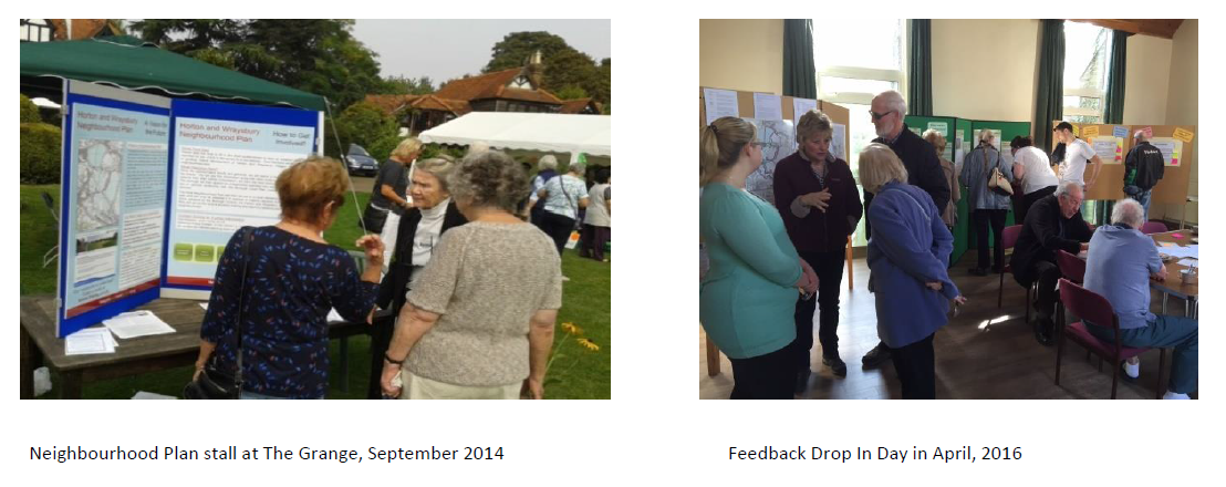
The community engagement process began in 2013 with two initial consultation events which took place in mid-April 2013 — one in Wraysbury Village Hall, the other in Champney Hall, Horton. At these publicised events, residents listed their concerns and ideas on various topics.
Both events were well supported by residents, and contact details were taken of those who attended. During the remainder of 2013, the Steering Group held meetings to assimilate the feedback and issues gained from the initial consultations and to formulate ideas and objectives aimed at addressing villagers’ aspirations.
The Steering Group then concentrated on establishing a Vision for the area, and nominated Topic Group leaders to work on Housing & Built Environment, Community, Environment, Transport & Travel and Business. The Topic Groups continued to gather information, including contacting local groups, and our Neighbourhood Plan website was set up to keep residents informed of progress. The Parish Council websites were also used to provide progress updates.
The Steering Group continued to formulate issues and objectives from residents’ concerns, and a questionnaire survey was constructed to get the views of the community on the initial aims. This was run from September 1 to November 7, 2014, online via the Borough Council’s Survey Monkey system so data could easily be assessed. Paper copies were made available to those without computer access, and special meetings with the Age Concern groups were held, along with assistance at the village Container Library for young and old. Publicity for the questionnaire was extensive, with a glossy leaflet drop to all addresses in our neighbourhood, plus an article and advert in the local magazine, which has 2,500 copies distributed to all households and drop points in both villages, and also using the villages’ Facebook page, the Neighbourhood Plan and Parish Councils’ websites. Posters were on display in the villages. Open Days were held during September to promote the questionnaire in both villages, which received good community response, plus a stand at the popular St Andrew’s Church Garden Party event.
The Steering Group then worked on analysing the responses and comments from the questionnaire during the early part of 2015 and from those, formed Objectives on the various Topics – Housing, Environment, Community, Transport/Travel, and Business/Economy. We have had an area Character Assessment carried out by planners organised by Planning Aid England. This has been added to with our local knowledge to make it more comprehensive.
It was recognised that more direct engagement with the community was needed to explain the background to the process and the constraints to development regarding flood zones and Green Belt in our area, and to seek views of parishioners on the proposed policy ideas. An Open Day was held in April 2016 in Wraysbury Village Hall for feedback on the proposals, and this was combined with an online survey until the beginning of May. Promotion for this was through a neighbourhood-wide mailshot, posters, plus Facebook and local paper publicity, with over 200 responses being received.
Continued updates on the Plan’s progress were carried out using the Neighbourhood Plan website and Facebook page as well as the Wraysbury News Facebook site, keeping residents informed and inviting comments. Face-to-face conversations also took place with local businesses to inform them of the Plan and assess their needs and concerns. Throughout the process, the Steering Group has regularly consulted with both Parish Councils.
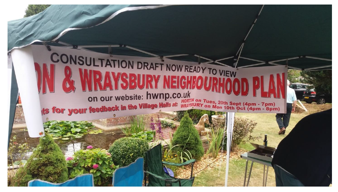
After analysing the evidence gathered from the various surveys, the Steering Group finalised the Draft Horton and Wraysbury Neighbourhood Plan in September 2016. The Regulation 14 Pre-Submission Consultation on the document was launched at St Andrew’s Church Garden Party in Wraysbury on September 3rd. This was followed by a public Drop-in event on October 10 (4 pm – 8 pm) in Wraysbury Village Hall.
The consultation ran for an eight-week period from September 3rd until October 31st. A co-ordinated publicity campaign was undertaken which included distributing a four-page A5 leaflet to all addresses in Horton and Wraysbury, detailing where the full draft plan could be viewed and comments could be made. The leaflet also contained a non-technical brief version of the Plan which set out the most important points- and publicised the open day events. A notice and link to the Plan was added to the Horton and Wraysbury Neighbourhood Plan website, the Wraysbury Parish Council website, plus the Wraysbury News Facebook Page. In both villages, copies of the full paper version of the Draft Plan, along with large printouts of the Summary Version, were available in key stores and community sites, and large publicity banners were displayed. The consultation was covered in the local press, and notifications were sent to statutory and non-statutory consultees.
The responses to the consultation were analysed, and the Plan was amended as appropriate.
< Previous | ^ Top | Next >