
This document represents the Neighbourhood Plan for Horton and Wraysbury area ward. The Royal Borough of Windsor & Maidenhead, as the local planning authority, designated a Neighbourhood Area for the parishes of Horton and Wraysbury in May 2013. This plan has been prepared by the Steering Group (made up of Parish Councillors and members of the community) with the full consent of both Horton and Wraysbury Parish Councils but submitted by Wraysbury Parish Council as the Qualifying Body.
The Horton and Wraysbury Neighbourhood Plan (H&WNP) is prepared in accordance with the Town & Country Planning Act 1990, the Planning & Compulsory Purchase Act 2004, the Localism Act 2011 and the Neighbourhood Planning Regulations 2012.
The Steering Group has prepared the plan to deliver a vision for the future of the area and to set out how that vision will be realised through planning and controlling land use and development change over the plan period 2018 to 2033. There are constraints to development within Green Belt as well as flood zone restrictions and that is why a neighbourhood plan is important to control what is built and where.
Neighbourhood Plans are required to be in general conformity with the strategic policies of the Local Plan ('Development Plan’) of the Local Planning Authority, the Royal Borough of Windsor and Maidenhead ('RBWM’ or 'the Borough’) and the Secretary of State’s advice, including National Planning Policy Framework ('NPPF’).
The purpose of the Neighbourhood Plan is to guide specific aspects of development within the plan area and provide guidance to applicants wishing to submit planning applications for development within the parishes. Once a Neighbourhood Plan is brought into legal force, decisions on whether or not to grant planning applications must be consistent with the Neighbourhood Plan, unless material circumstances dictate otherwise.
Our policies as stated in this Plan will take priority over non-strategic policies in the existing RBWM Local Plan, giving our communities a real and lasting tool to influence the future of our neighbourhood. Where this plan is silent, then applicants need to comply with the relevant Local Plan policy as well as the NPPF, e.g. relating to Green Belt policy.
The process of producing a plan has sought to involve the community as widely as possible and the different topic areas are reflective of matters that are of considerable importance to Horton and Wraysbury, its residents, businesses and community groups.
Each section of the plan covers a different topic. Under each heading there is the justification for the policies presented which provides the necessary understanding of the policy and what it is seeking to achieve. The policies themselves are presented in the boxes and it is these policies against which planning applications will be assessed.
The Plan Period is 15 years, so it is intended that our plan runs for the period from April 2018 until March 2033. An April start also allows us to fit in with the way RBWM monitors development, in financial years (April to March).
We recognise that the Plan will be delivered and implemented by different stakeholders and partners and that it is not a rigid blueprint but instead it provides a framework for change through its vision, strategy and policies.
As new challenges and opportunities are likely to arise over the plan period, the intention is for the Neighbourhood Plan to be reviewed every 5 years. Within this context the Parish Councils will assess the need or otherwise for any made Neighbourhood Plan to be reviewed once the emerging Local Plan is adopted.
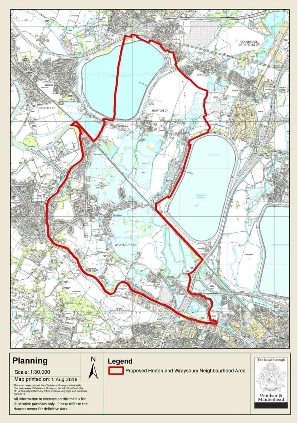
NEIGHBOURHOOD PLAN AREA
The map below shows the boundary of the Neighbourhood Plan area, which is contiguous with the ward boundary of Horton and Wraysbury.
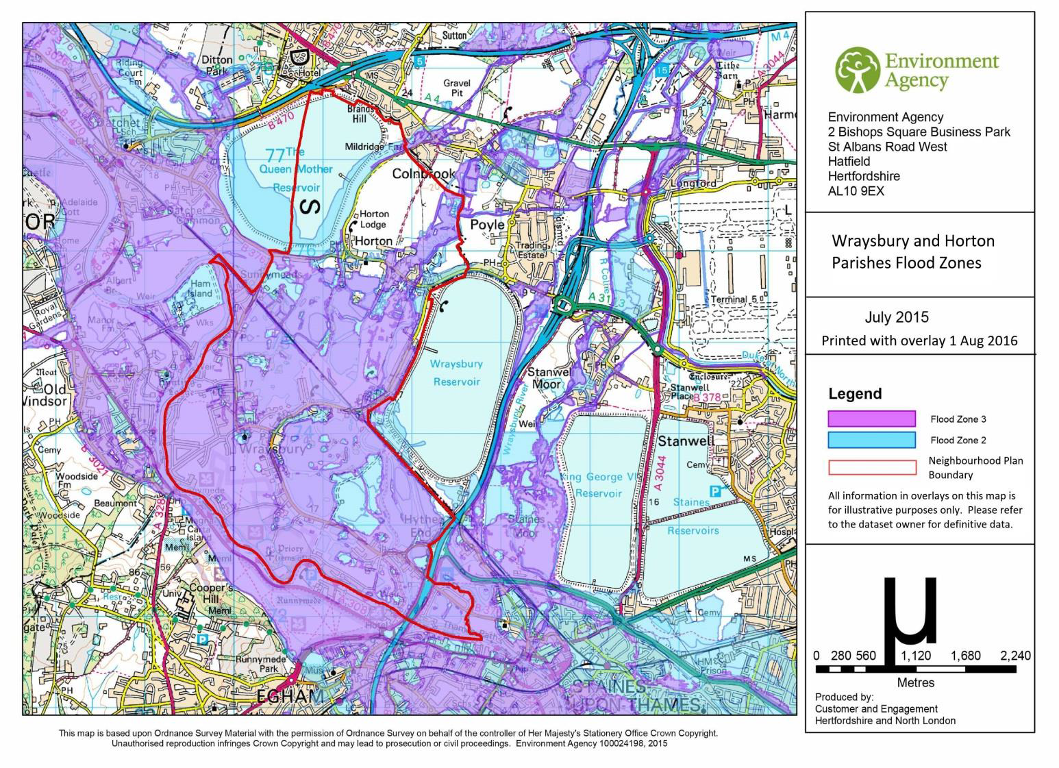
FLOOD PLAIN AREA
The map below, taken from the RBWM website, shows flood zones 2 & 3.
GREEN BELT AREA
The map below identifies Green Belt within the Neighbourhood Plan area.
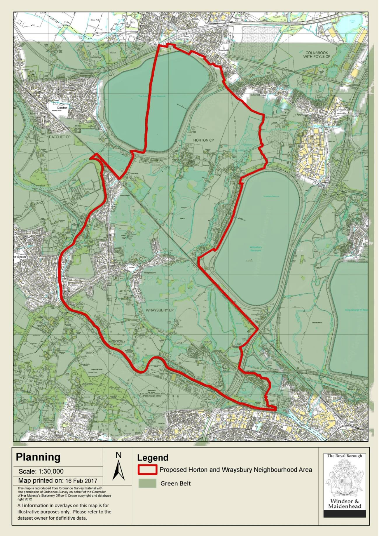
NB. Although not shown as part of the Green Belt, Wraysbury Village Green is covered by the George III Enclosure Act of 1799.
The National Planning Policy Framework (NPPF) states:
“Neighbourhood planning gives communities direct power to develop a shared vision for their neighbourhood and deliver the sustainable development they need. Parishes … can use neighbourhood planning to set planning policies through neighbourhood plans to determine decisions on planning applications (para. 183).
“Neighbourhood planning provides a powerful set of tools for local people to ensure that they get the right types of development for their community. The ambition of the neighbourhood should be aligned with the strategic needs and priorities of the wider local area. Neighbourhood plans must be in general conformity with the strategic policies of the Local Plan. To facilitate this, local planning authorities should set out clearly their strategic policies for the area and ensure that an up-to-date Local Plan is in place as quickly as possible.
“Neighbourhood plans should reflect these policies and neighbourhoods should plan positively to support them. Neighbourhood plans and orders should not promote less development than set out in the Local Plan or undermine its strategic policies (para. 184).
“Outside these strategic elements, neighbourhood plans will be able to shape and direct sustainable development in their area. Once a neighbourhood plan has demonstrated its general conformity with the strategic policies of the Local Plan and is brought into force, the policies it contains take precedence over existing non-strategic policies in the Local Plan for that neighbourhood, where they are in conflict. Local planning authorities should avoid duplicating planning processes for non-strategic policies where a neighbourhood plan is in preparation (para. 185).”
Section 9 of the NPPF is entitled Protecting Green Belt Land and makes clear that Green Belt boundaries can only be altered by the Local Plan rather than the Neighbourhood Plan. Its purpose is to prevent urban sprawl by keeping land permanently open and the essential characteristics are their openness and permanence.
The construction of all new buildings is inappropriate apart from:
Furthermore, the NPPF states that “…inappropriate development is, by definition, harmful and should not be approved, unless in very special circumstances.”
In July 2018, the Government published a revised NPPF. It is not considered that the revisions materially impact upon this Neighbourhood Plan’s policies or its approach to development. However, this document refers throughout to the previous 2012 version and, in accordance with paragraph 214 of the 2018 version, “the policies in the previous Framework will apply for the purpose of examining plans, where those plans have been submitted on or before 24th January 2019.”
At a local level, the key document is the Royal Borough of Windsor and Maidenhead Borough Local Plan adopted in 1999 and amended in 2013, and in particular its “saved Policies”. It contains a variety of strategic policies to guide the policies of this Neighbourhood Plan. As at November 2019 the Royal Borough is preparing a replacement Borough Local Plan (BLP) which sets out the overall strategy for development across the Royal Borough and has been published.
The Submission Version of the Borough Local Plan was submitted to the Secretary of State on 31st January 2018. This updates the housing target for the Royal Borough for the period up to 2033. An examination is being conducted by an Inspector, Louise Phillips, and public hearings were held in the summer of 2018. Following those hearings, the examination has been suspended, pending further work and public consultation on possible changes to the Plan.
In October 2019, the Royal Borough commenced a public consultation on Proposed Changes to the Submission Plan. That version now only proposes the allocation of one site within the Neighbourhood Plan area, Land East of Queen Mother Reservoir at Horton, for approximately 100 units. It is also proposed to take that site out of the Green Belt. Two other sites, which had been allocated in the previous version, Land East of Coppermill Road at Horton and Tithe Farm, Wraysbury, are no longer being proposed as allocations.
Any planning application on the remaining allocation will be expected to conform to the consultation requirements, with Neighbourhood Plan Development Details being submitted as set out in Policy SusDev 01 and in Appendix D. The draft Borough Local Plan, including its allocation, is emerging policy which could change further as a result of its examination. The Neighbourhood Plan is required by legislation to be in general conformity with strategic policies contained in the adopted (not emerging) Local Plan.
However, whilst the Neighbourhood Plan does not allocate any housing sites and cannot redraw Green Belt boundaries, its policies are generally consistent with the overall strategy of the draft BLP which stresses the importance of protecting the Green Belt from inappropriate development and the need to avoid areas at risk of flooding. The Plan also notes that Wraysbury is one of the areas in the Royal Borough at the highest risk from severe flooding.
The 2003 Borough Local Plan defines the Green Belt boundary; however, the built-up areas of Wraysbury are excluded from the Green Belt, and Horton and Coppermill Road are Recognised Settlements within the Green Belt. The boundaries are shown on the Green Belt map (see Section 2a, Neighbourhood Plan Area Maps).
Planning policy regarding flood risk is covered under the Borough 2003 Local Plan Policy F1.
The development plan also includes the following adopted plans that cover the Neighbourhood Area — the Replacement Minerals Local Plan and the Waste Local Plan for Berkshire. However, these plans address matters that legally cannot be within the scope of a Neighbourhood Plan.
< Previous | ^ Top | Next >