
Our communities are fortunate to have a beautiful, historic setting, with a Conservation Area, many listed buildings and an historic landscape character. In Eton, one of the key issues raised by residents is, ‘how to enable some limited growth to help meet current and potential needs whilst retaining Eton largely as is.’
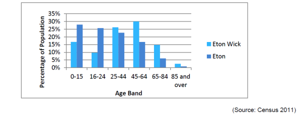
The resident characteristics across the plan area are varied, with both the town and village having distinct characteristics. According to the 2011 census, in Eton, 28.5% of households are owner occupied, 19.4% are private rented, 13% are social rented or shared ownership, and 39% are other.6 The ‘other’ proportion of homes generally represents college accommodation. The number of College residents and dwellings in Eton is considerably more than Eton Wick. Eton College accommodates around 1,320 boarding students.7
In Eton Wick, 66.7% of households are owner occupied, 8.3% are private rented, 20.3% are social rented or shared ownership, and 4.7% are other.8 This contrasts with Eton and serves to demonstrate that together, Eton and Eton Wick offer a range of different housing options. The difference in age distribution between Eton and Eton Wick is reflective of the differences in tenure. It is through a variety of tenures that the community has remained diverse, and it is the intention of the Neighbourhood Plan that new housing should continue to accommodate for diversity at a local scale.
Graph 1 – Age distribution in Eton and Eton Wick
As it is, Eton has a distinct hierarchy of areas reflecting the age and type of buildings present. This spectrum of development ranges from the Mediaeval through Victorian up to the present day.
Owing to the water and land constraints such as Common Land in and around Eton and Eton Wick, both settlements enjoy many long and uninterrupted views to and from the town. Due to its hilltop location, views to Windsor Castle are the most prominent. Views to Eton College buildings and local churches also play an important role in the area.
Preliminary figures discussed with RBWM planning officers indicate that the Town Council area of Eton and Eton Wick will provide ~96 homes as housing supply by 2030 if current trends of infill and small site allocation are to continue. This figure is derived from historical trends in housing supply and is not a firm target allocated by RBWM.
Key issues identified during the process of collecting evidence and conducting consultation include:
i. Land Constraints
Owing to the constraints of geography, land ownership, flood risk and historic designation, there are few obvious sites within Eton for housing development. There has, however, been a history of relatively successful small-scale infill or demolish-and-rebuild development within the town. Further future infill development should respect the small scale of the traditional buildings nearby.
There are opportunities for housing and business development in Eton Wick. However, constraints include the presence of Common Land and Lammas Land; Green Belt (which covers almost all greenfield land in the area); and large areas at risk from flooding. It is important to understand that this Plan does not allocate specific sites for housing development.
ii. Character and Heritage
Eton is a town of high heritage value and is designated as a Conservation Area. There is a large body of evidence gathered during consultation that supports initiatives to conserve and protect heritage characteristics including historic buildings and landscapes. This Plan lays out a set of guidelines with the intention to ensure that new housing does not compromise the existing character and historic value of the area, including the character of Eton as a whole settlement, the importance of listed buildings designated within the whole plan area, and the relationship between the rural and urban identity, particularly, views to Eton and Windsor Castle from rural locations.
Eton Wick is historically a farming community. Despite its steady growth over the past decades, it retains much of its character as an agricultural settlement. The village can be characterised as having numerous styles of development, yet none stand out as particularly out of place or extraordinary in an English Home Counties setting. The buildings are generally built to a high standard of design and use high quality materials.
iii. Infrastructure and Public Services
Commentary on strained infrastructure within the Neighbourhood Plan area was abundant, particularly concerning transport issues. Indeed, the RBWM emerging Local Plan acknowledges that transport infrastructure is under strain in Eton and Windsor. The community therefore accepts new development, but only when it will not place unnecessary strain on existing infrastructure – principally roads and parking.
iv. Floodplain Risks
Being bounded on three sides by the River Thames, the Eton and Eton Wick area is especially prone to flooding. Furthermore, as much of the housing stock is of an historic nature, some may have shallow foundations susceptible to settlement which can be exacerbated by rising and falling water tables.
Infrastructure in Eton Wick is generally strained, particularly concerning the congested road network and sewage facilities that are old and prone to flooding. It is important that suitable infrastructure provision is provided, commensurate with the scale of development proposed.
This Neighbourhood Plan seeks to encourage small-scale development that is delivered at a sustainable rate and with sufficient public service contributions so as to ensure that benefits to community infrastructure are realised alongside new development. Major developments (10+ residential units or 0.5 hectares+) may be accepted provided they make commensurate contributions to community facilities and services (social infrastructure) and have a phasing strategy to ensure that a large influx of new developments does not present an immediate negative impact on local services.
The evidence to support this policy comes from consultation feedback and demographic data (see Appendix 8) which has revealed limited housing choices for both the elderly and young populations of Eton and Eton Wick wishing to stay in the local area. Applicants should demonstrate that their proposals reflect current evidence on the local needs in the town and village9. In addition, the policy seeks to encourage sympathetic infill schemes in Eton and small-scale incremental schemes in Eton Wick where they would help to meet housing needs locally. There is a housing shortage in England and this policy aims to encourage new housing development. The community have also identified strained local infrastructure and services throughout consultation, including drainage and sewerage, highways and lack of health facilities in Eton Wick (see Consultation Statement). The policy encourages the reinforcement of local services to ameliorate the strain on the existing infrastructure (including highways and a lack of health provision specifically in Eton Wick) and minimise the negative effects of construction. Where relevant, a construction management plan should demonstrate how it responds to the proposed phasing and infrastructure strategy of a major development.
This Plan supports infill as the dominant form of housing development over the plan period, and it will be necessary to ensure it is appropriate to its local context and environment. Infill development is by its very nature in close proximity to existing homes and herein lies its risks. However, this Neighbourhood Plan supports development of much-needed new homes that contribute to the existing street scenes and townscapes. In the Neighbourhood Planning area, this is a priority issue owing to its heritage character. Infill development must therefore go above and beyond its potential functional impact, including light and access, and instead, offer additional efforts to make sure new development matches its context.
New dwellings and residential extensions should respect local character and make a positive contribution to it. Development should reflect local architectural vernacular and respect residential amenity.
Consultation results have revealed a feeling that certain new developments are undesirable due to their damaging effects on the character of Eton and Eton Wick, e.g., through noise pollution and odour. This policy therefore aims to shape new infill development and extensions so that they do not detract from the heritage character of Eton and the village character of Eton Wick.
Eton is a town of extremely high heritage value, having been gifted with a large number of well-designed buildings. The town is designated as a Conservation Area. There are over 130 listed buildings or significant non-listed buildings in Eton according to the Conservation Area Character Assessment10. Consultation has consistently revealed that the community value the character of their town, and it is the intention of the Neighbourhood Plan to safeguard Eton’s valuable heritage traits.
A Design Guide has been produced to promote development options that integrate with the existing context of the town and village. It does this by outlining detailed design notes for specific areas of the town – the Character Areas; in addition to identifying streets where heritage setting is especially sensitive in a hierarchy of streets.
As an aid to meeting the aspirations of the Neighbourhood Plan, a Design Guide has been developed. The Design Guide outlines the different Character Areas in Eton and provides a hierarchy of streets. The Character Areas and hierarchy of streets identify the key urban and architectural features specific to each area in Eton. The hierarchy of streets plan is provided to guide development in Eton based on areas of particularly high historic value.
The heritage credentials of Eton clearly indicate a settlement of national cultural value. Eton has over 90 listed buildings and numerous significant non-listed buildings. Community consultation supports the need to protect historic assets, and has consistently demonstrated the heritage character of Eton is valued across the entire Neighbourhood Plan area. The Design Guide should be read alongside any relevant evidence such as a Conservation Area Appraisal Statement and Townscape Assessments that help to identify features and the appearance of the surrounding area.
Eton Wick is a very different environment to Eton, featuring a variety of different styles of development as the village has evolved. Design codes relating to the building aesthetics are therefore not as appropriate in Eton Wick as they are in Eton.
New development should reflect the village vernacular and rural setting of Eton Wick by:
The residents of Eton Wick value their rural setting and access to open space afforded by local public rights of way, whether they are within the village or external to it. The open green fields that encircle the village and generous green infrastructure that permeates through the settlement are the village's key characteristics. The policy seeks to maintain this open and green character for new development that emerges over the forthcoming plan period. The existing network of public footpaths, bridleways and cycleways ensures that Eton Wick retains its close connection with surrounding farms, the Thames and Jubilee Rivers, Dorney, Boveney and Eton. It is also apparent from consultation that the public linkages around Eton Wick also support their relationship with Eton, and the sense of closeness between the two settlements. At present there are some examples of little or no garden space for some dwellings. As such, what green space that does exist is precious.
The Neighbourhood Plan seeks to protect important local views.
Development should respect the following important local views:
Appendix 2 provides a detailed analysis of these important local views and identifies related viewing corridors. Proposals within viewing corridors should not detract from views of the landmark or landscape.
The protected views serve to preserve the role that local historic landmarks have on the character of the area, including Windsor Castle, Eton College Chapel (and other College buildings), St. John's Church, Windsor Railway Bridge (designed by Isambard Kingdom Brunel) and brick viaduct.
There is strong support from the local community for protecting notable views from being obscured by new development. The same justification for policy HD3 outlining the heritage significance of the Neighbourhood Plan Area also bears relevance for this policy. The Conservation Area Character Appraisal, prepared by RBWM, has also helped the community to identify its key views.
A great number of the views are to Windsor Castle, which is a Scheduled Monument. Windsor Castle's location atop Castle Hill contrasts with the relatively low and flat agricultural and meadow land around Eton and Eton Wick. This means that Windsor Castle is visible from much of the Neighbourhood Plan area. Not only are the views to Windsor Castle important from a heritage perspective, they also help with navigation and define a uniting characteristic across Eton and Eton Wick.
Having regard to an identified view should not be interpreted as a means of preventing development. Development within viewing corridors is to be encouraged where it helps to meet local needs or regenerate the neighbourhood area. However, new proposals within identified corridors should not detract from the landmark or landscape. Appendix 2 sets out the reasons for each designation; the view's distinctive features shall inform the consideration of applications.
The process for view selection was initially community driven; the Steering Group received approximately 60+ recommendations from Eton and Eton Wick residents. These suggestions were then narrowed down by AECOM planning consultants according to the key principles and criteria utilised by the Greater London Authority in the London View Management Framework (and other best practice examples). Guidance states the view must focus on a feature of (heritage) value, considering the merits and characteristics of the foreground, middle ground and background. The views in Appendix 2 focus on Windsor Castle, Eton College, or the Windsor Railway Bridge and viaduct. Many of the views include other valuable heritage characteristics such as Eton High Street, Brocas / Lammas Land, and the Riverside.
Eton and Eton Wick sit in the floodplain of the Thames and Jubilee rivers. There is very little in the way of topography that separates these rivers from the settlements, so flooding poses a real risk across the Neighbourhood Plan area. The following policy seeks to ensure that new development will not heighten the flooding risks currently observed in Eton and Eton Wick.
The following criteria shall guide decisions for basement development:
The consultation statement evidences a strong desire from the local community to manage flood risk locally. Flood risk prevention measures were one of the critical factors discussed at the drop-in events and consultation with the public. Flood risk is prevalent across the Neighbourhood Plan area, with the majority of open land classified as Flood Risk 2 or 3.
Some historic buildings are without well specified foundations and there is therefore a risk associated with developing basements that may both disrupt heritage foundations during construction, but also through the destabilisation caused by subterranean water course disruption.
The Strategic Flood Risk Assessment (2014), paragraph 6.4.4 page 33, includes a series of recommendations for basements, with relevant content transposed into the above policy. Consultation with the Environment Agency and Thames Water was used to refine the final policy. Criterion (v) was inserted following discussions with Thames Water and only applies when there is a waste outlet from the basement, i.e., a basement that includes toilets, bathrooms, and/or utility rooms. Consultees recommended that groundwater levels are monitored and appraised against the impacts of subterranean development.
6 For statistical purposes in the United Kingdom, a household is defined as "one person or a group of people who have the accommodation as their only or main residence and for a group, either share at least one meal a day or share the living accommodation, that is, a living room or sitting room.
7 Some may have been recorded at their parents’ addresses in the 2011 census, and therefore underrepresented in census statistics.
8 This is likely to be predominantly college accommodation where households are offered tenure under neither private nor social rent.
9 Evidence could include a Strategic Housing Market Assessment, demographic projections and forecasts and Census data.
10 Eton Conservation Area Appraisal (RBWM, 2009) Accessed at: https://www3.rbwm.gov.uk/downloads/download/216/conservation_areas.
< Previous | ^ Top | Next >