
Information in this document has been sourced from the booklet A History of Flooding and Flood Defences in Datchet 1600s to 2000s by Janet Kennish. See also https://datchethistory.org.uk
Datchet’s historical records contain many accounts of flooding including ‘great floods’ in the years 1774, 1809, 1822, 1852, 1894 and 1947 (right). All of these seem to have been more severe than that of 2014.
Lesser floods were a common fact of life and, until the late 1800s, dwellings were not built where flooding was likely. Historically, Datchet’s chief protection from flooding, apart from the riverbanks, were the bunds or embankments.
Farming communities have always understood, from experience, the importance of flood banking, ditching and drainage. From the Middle Ages to the early 1800s, farming was managed through the authority of Datchet Manor Courts. Court records show that the bunds at Sumptermead and Southley (now Southlea) have been used for centuries to control flood water and protect the village. (Court records from 1645 indicate that landowners were ‘fined for not amending Sumptermead Bank’, and instructed to ‘make up the causeway leading to Sandley House’). Landowners were obliged to maintain and repair bridges, fences, ditches, watercourses, gates, and flood banks on their land or face a fine. There are numerous records of landowners being fined and ordered to carry out repairs to these bunds which are still relevant to the village today.
The role of the Sumptermead bund seems to have been to allow the swollen river to flood Sumptermead, historically a valuable water meadow, to prevent floodwater flowing further north and east.
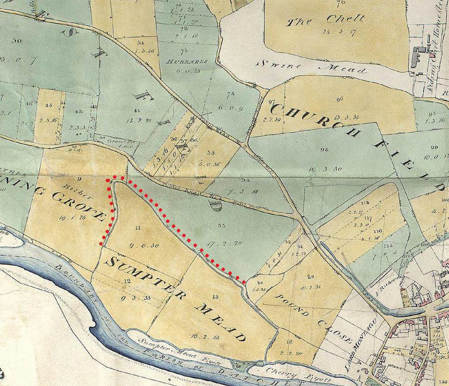
Left: Section of Enclosure map 1833. Sumptermead bank is shown by a dotted red line in this detail, the inner line being the ditch below the bank which feeds back into the Thames. The road running diagonally across the map is Slough Road, with Eton Road branching off below.
In 1850, the new railway line and its embankment sliced through Sumptermead Bank, at the point closest to Eton Road. An underpass was made beneath the railway line to allow access to the fields on both sides of it. A new road to Windsor was also built. (Before then, the route to Windsor was via Datchet Bridge and through the Castle grounds, or via Eton Road.)
Sumptermead Bank had to be raised and widened after the great flood of 1852 because the new Windsor Road had stopped the flood waters from taking their usual course over Home Park. They were thrown back over the estate of Black Potts then across the low lands of Datchet on both sides of the railway, overflowing Sumptermead Bank and inundating the village.
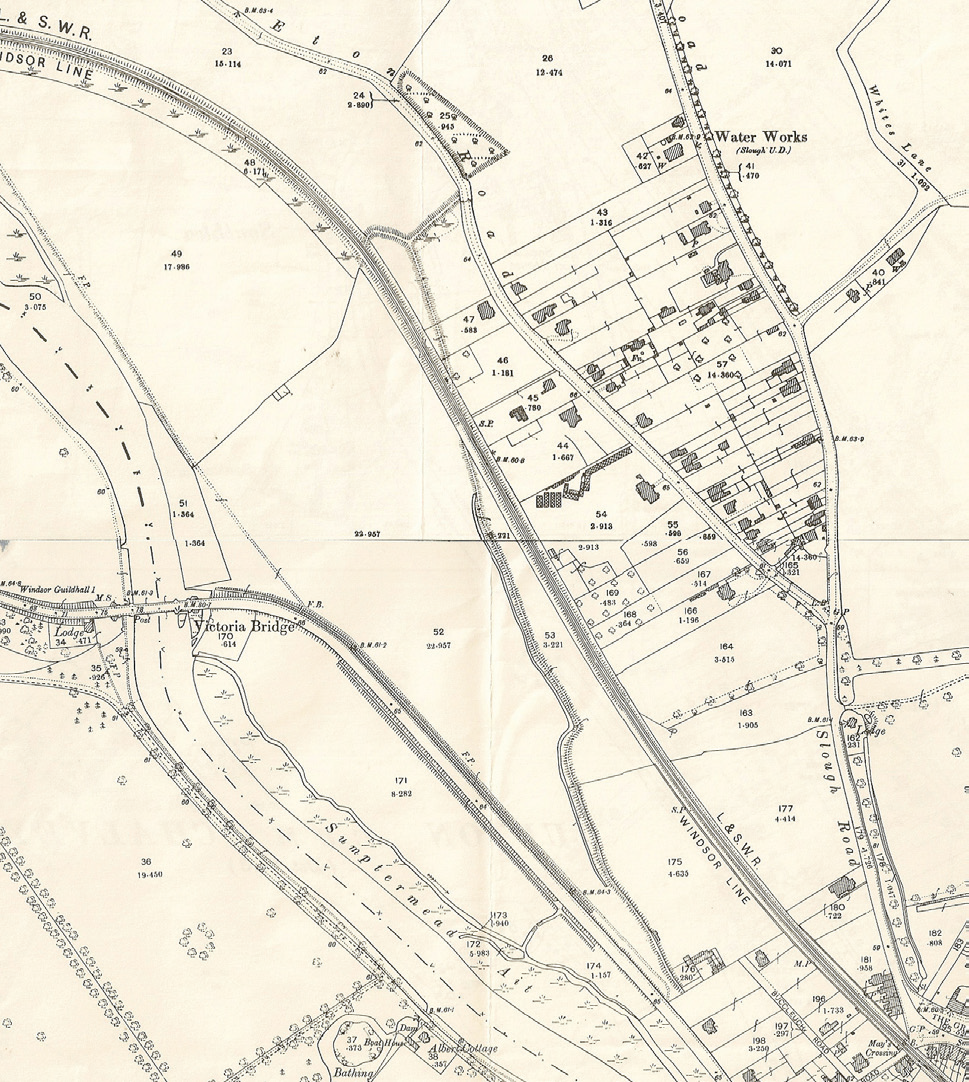
Left: Section of 1899 OS map showing Sumptermead Bank. By 1899 the arm of the bank running south-west had been removed and only the diagonal line of the field boundary remained. This can still be traced across the golf course which lies to the west of the railway line.
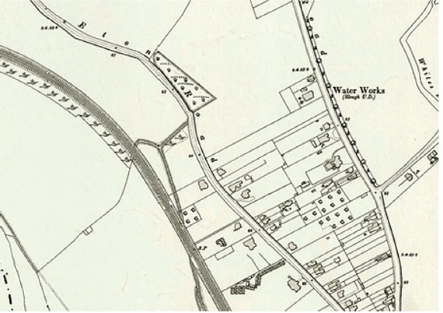
The access tunnel under the railway line is shown by two white semicircles, which can be seen more clearly, left, in the section of the 1912 OS map.
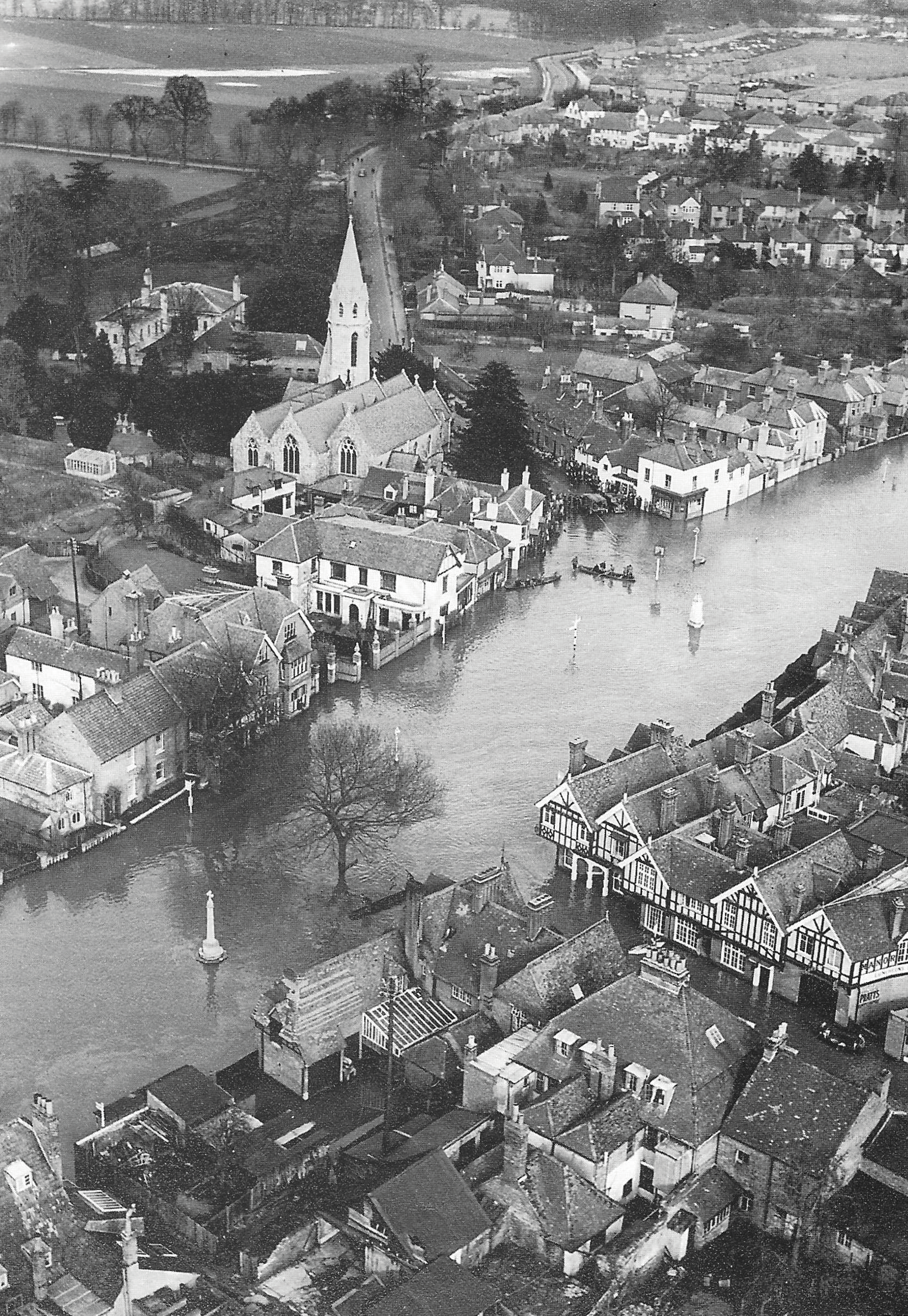
Flood water could flow underneath the railway line into a holding area where it was held in check by the bund except in the worst conditions, as in 1947, when the railway line had flooded and water rushed along it and through The Green.
Following the 1947 flood, Datchet Parish Council approached the Crown Estate (the Golf Club’s landowners) about the cost of repairs to the bank and the floodbanks there but there was nothing in the lease or correspondence that suggested they had any liability.
The Council’s solicitor reported that the Thames Conservancy also accepted no responsibility for the upkeep of the flood bank. In the end it was decided to pay for repairs regardless of cost and as a matter of urgency.
A contributing factor to the lesser flood of 2003 and the major one of 2014 was the removal of a section of Sumptermead Bund at Eton End School close to the railway line. In brief, it seems that a previous extension at the school had encroached on the original extent of the bund and a section had been removed, leaving a substantial gap.
Below left, Section OS map 2021 showing Eton End School and grounds, next to the railway line and bund.
In January 2003, the new Jubilee River was put into operation for the first time. This is a highly contentious subject but the flood water seems to have entered the village down the railway line from the breach in the flood bank at Eton End School since nothing was in its way.
The school, having suffered badly from the flood, applied for planning permission to reconstruct and realign the flood bank. Although Datchet Parish Council objected to ‘piecemeal’ flood defence work and recommended that Sumptermead Bank be reinstated properly and with urgency by the appropriate authority, permission was eventually granted in December for a ‘sandbag wall’ (a solidified concrete bag wall) across the gap rather than a permanent bund structure.
In May 2003, the Environment Agency (EA), which recognised the need to re-instate the bund, had suggested that the reinstated bund might be adopted by the Agency in future, dependent on the outcomes of the Lower Thames Project (River Thames Scheme Datchet to Teddington).
The 2014 flood was much more serious than that of 2003. The ‘sandbag wall’ section of Sumptermead Bank was breached and flood waters poured down the railway line, as in 2003, resulting in extensive flooding. Early attempts to stop the flow from the school’s side had to be abandoned as the water was so high, but the army successfully plugged the gap with sandbags from the railway line. The flow stopped as if a tap had been turned off and the water in the village centre subsided rapidly. Since then, a permanent repair to this breach has been made and Sumptermead Bund has been rebuilt to the standard required by the EA.
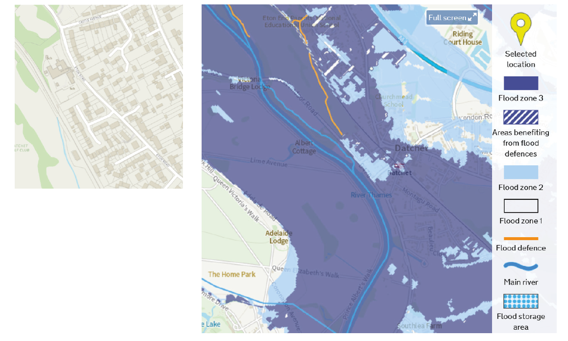
Below right, Sumptermead Bund is indicated as a flood defence on the present-day Government Flood Map for Planning.
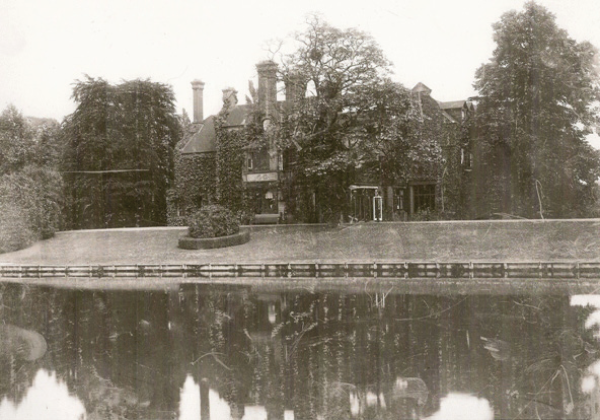
Land in the southern and eastern parts of the parish is also historically vulnerable. Records of the Barker Bridge House Trust29 show that the Trust paid for numerous repairs to the Southlea bank in the 1800s. This bank protected Rosenau House, and the land to its east and south.
Right, detail from 1899 OS map shows Rosenau’s raised platform above its steep river bank. The bank continues north to a boat house and then, continuing further along from there, the line of trees represents the old causeway from Datchet to Southlea’s riverside houses.
Below, this 1880/90s photograph shows the steep Southlea bund at Rosenau. This high bank above the river may have its origin in the one rebuilt by the Barker Bridge House Trust in 1830.

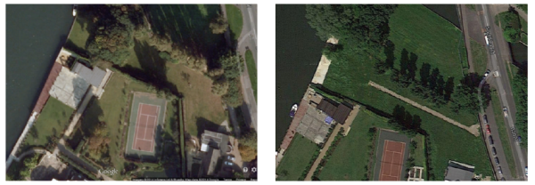
Rosenau has since been replaced by Woollacoombe which dates from the 1930s. In recent times another house, Poplars, was built in its grounds. It is in an L-shaped plot with the house close to the road and a section of river frontage. In 2013, presumably to improve the view, the clump of trees in Poplars garden, above left, was removed and the bank was flattened, above right.
This deliberate removal of the bund led to a serious breach of the river bank in 2014. Water flooded up to the property’s front wall and was in danger of bursting through, threatening Southlea Road and beyond. The navy, with the help of many volunteers, built a sandbag wall to contain the river.
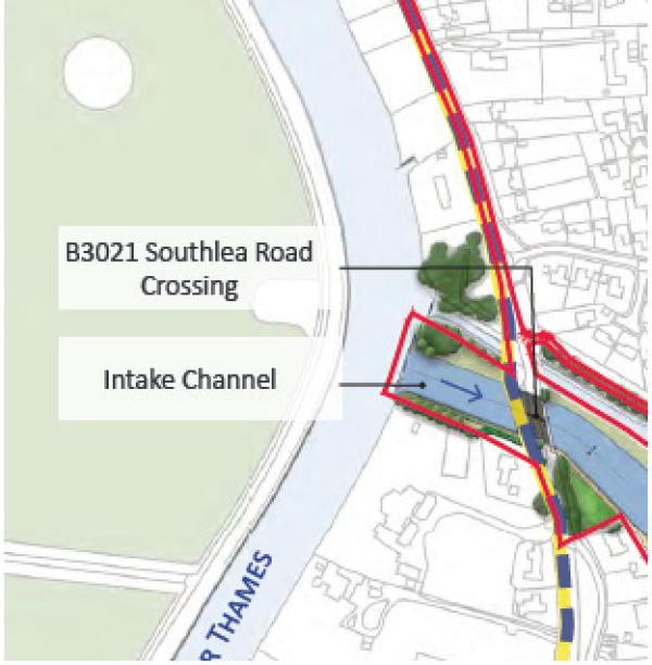
This section of the Southlea riverside bund has not been reinstated and no agreement to do so has been reached between the owner, the EA and RBWM. In case of flood, the EA currently proposes that moveable/demountable flood barriers will be brought in to protect both sides of Southlea Road. If the Datchet section of the River Thames Scheme had gone ahead, this area, close to the water intake, would have formed part of the scheme, removing the threat.
Right, detail from Channel Section 1 drawing River Thames Scheme.
29 http://www.thebridgehousetrust.co.uk/.