
5.1 This chapter is framed around the following objectives:
Objective 2: To conserve and enhance the natural environment, biodiversity and important wildlife habitats
5.2 It presents policies, and projects, in respect of biodiversity and flood risk.
5.3 The NPPF recognises the importance of conserving and protecting the natural environment. This is also reflected in the Environment Act (2021) which, coupled with the declaration of the Environment and Climate Emergency by RBWM, has raised awareness of the value and importance of biodiversity and natural habitats.
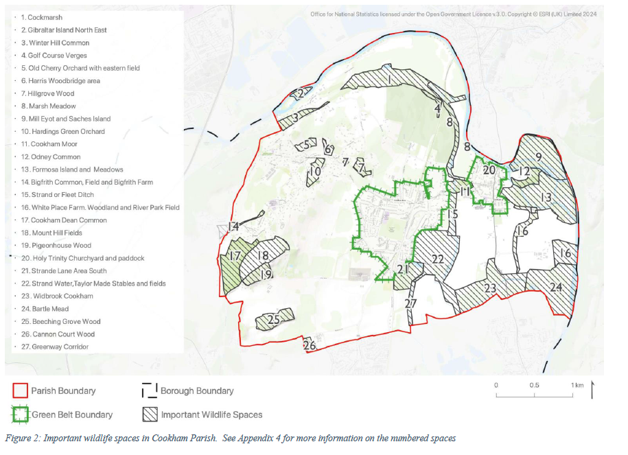
5.4 There are a number of important wildlife areas, designations and habitats in the Neighbourhood Plan area (see Figure 2) and immediately adjacent to it. These include the Cock Marsh Site of Special Scientific Interest (SSSI) and, just outside the Parish boundary, Bisham Woods SSSI and Local Nature Reserve, and the Chilterns Beechwood Special Area of Conservation: a site designated for protection at the European level (see mapping in Appendix 4). The Parish also includes a number of priority habitat areas, including areas of grassland, marsh and woodland. These extend beyond Cookham Parish and create a network of connected habitats (see mapping in Appendix 4). The quality of soils in the Parish is also important for biodiversity, with approximately 50% of organisms occupying the soil.
5.5 Locally, a number of actions to improve biodiversity have been identified in the RBWM Biodiversity Action Plan (see Box 5) and which biodiversity net gain plans should seek to support.
INFORMATION BOX 5: Biodiversity Action PlanThe RBWM Biodiversity Action Plan (BAP) covers the period 2022-26. Projects and initiatives identified in the BAP are supported by the Parish Council, and developers are encouraged to help deliver these where appropriate to proposals. It is recommended that the use of pesticides and herbicides be avoided within Cookham Parish on any public or private land to spare the environment. Objectives defined in the draft updated BAP include, but are not limited to:
Within built-up areas, the following objectives are identified:
|
5.6 Cookham Parish is surrounded by three significant and distinct areas of habitat: the River Thames, suburban Maidenhead and the Bisham Woods. Within the Parish, the built-up areas create barriers to the free movement and/or spread of flora and fauna, potentially creating species isolation which can result in in-breeding, a breakdown in ecological resilience and degrading biodiversity. Intensive farming on arable land creates additional barriers.
5.7 Development should be planned in such a way that avoids habitat loss and fragmentation, and opportunities should be sought to improve ecological connectivity, including through the creation, restoration and enhancement of linking habitats and ‘stepping stones’ through the landscape.
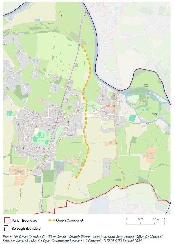
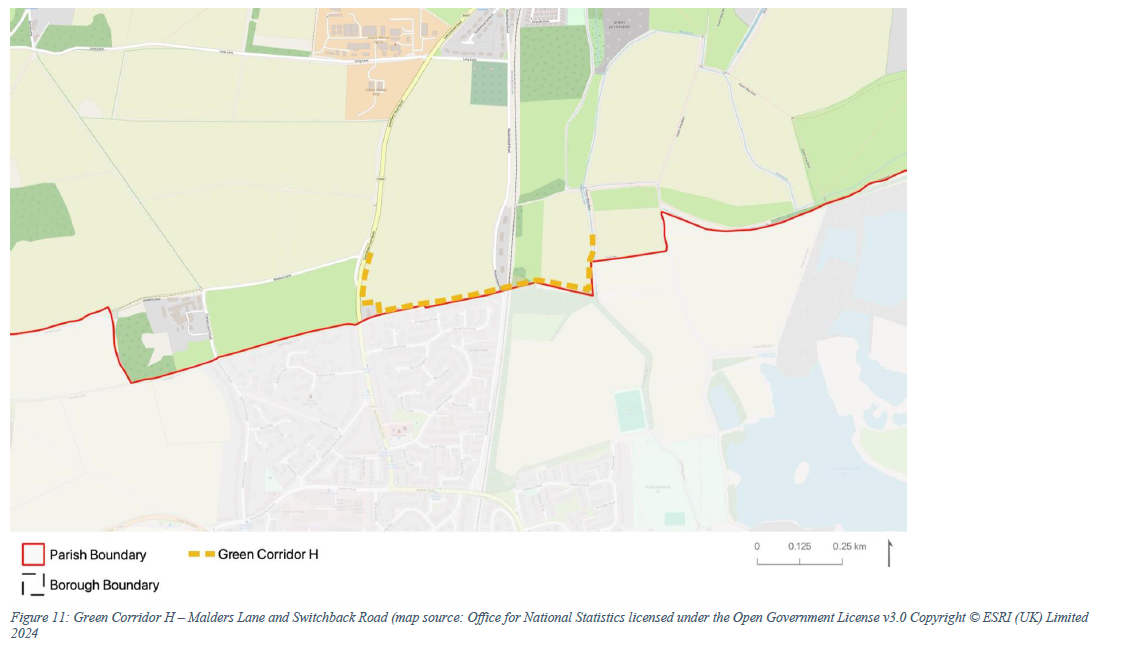
5.8 Identifying and securing wildlife or green corridors is essential to ensure the necessary replenishment and maintenance of species diversity for healthy ecological functioning. The aim of the corridors is to provide connectivity between major habitat areas of open water and woodland. Green corridors in the Plan area are illustrated in Figure 3 with more information presented in Table 1.
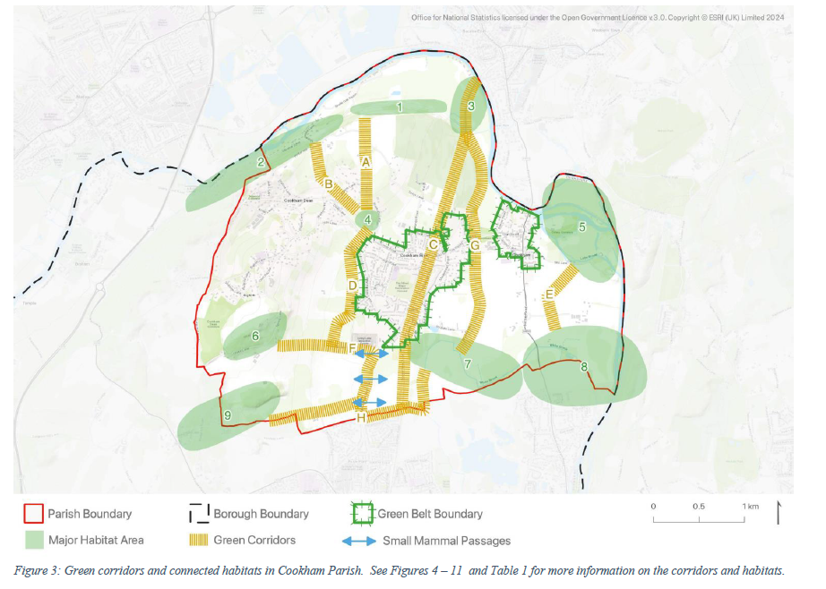
| Map Ref (Figure 3) | Name of Corridor | Connected Habitat Name (Figure 3) | Connected Habitat Type | Corridor Type | Type of Habitat/Species Created For |
|---|---|---|---|---|---|
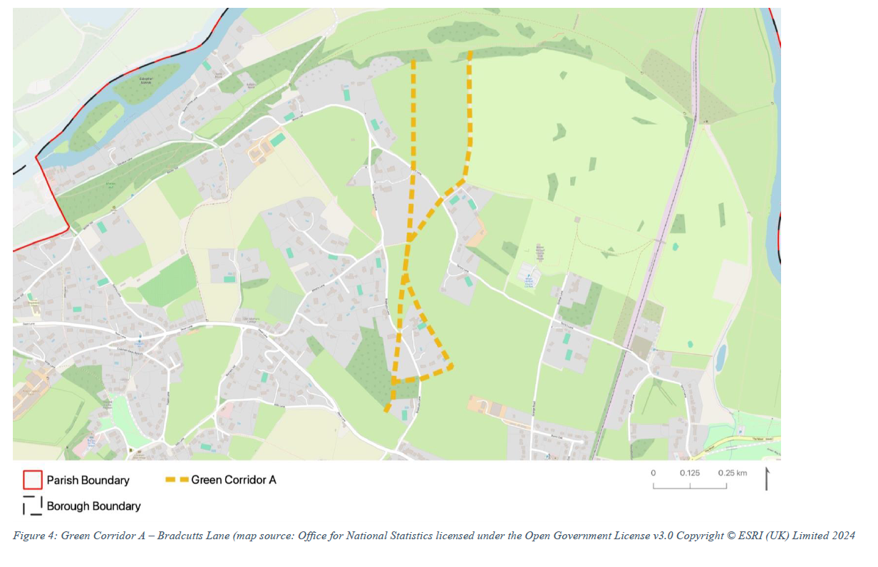
| A | Bradcutts Lane | Cockmarsh (1) and Hillgrove Wood (4) | Dry grassland w/ older trees | Hedgerow | Heathland, grassland and mature woodland |
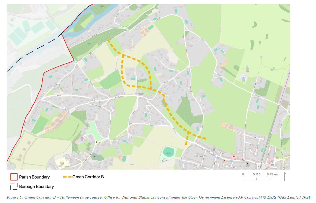
| B | Halloween | Winter Hill (2) and Hillgrove Wood (4) | Woodland | Hedgerow | Mature and semi-mature woodland |
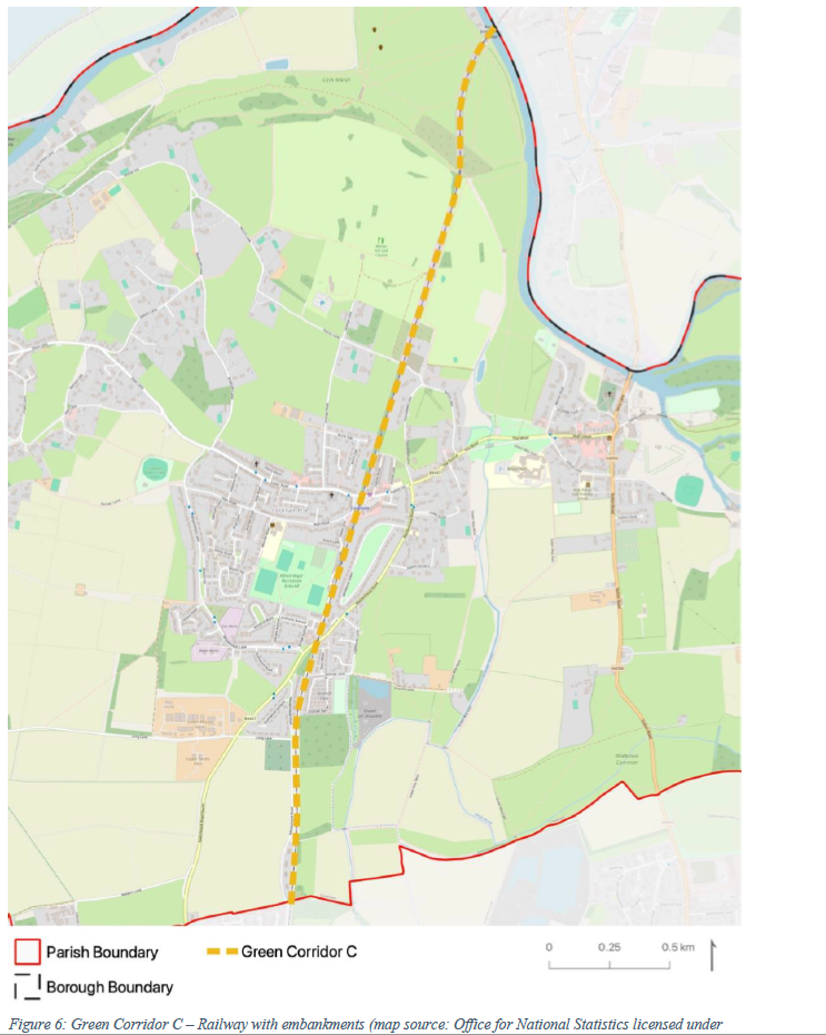
| C | Railway with embankments | - | Hedgerows and gardens | Grassland | Insects and wildflowers |
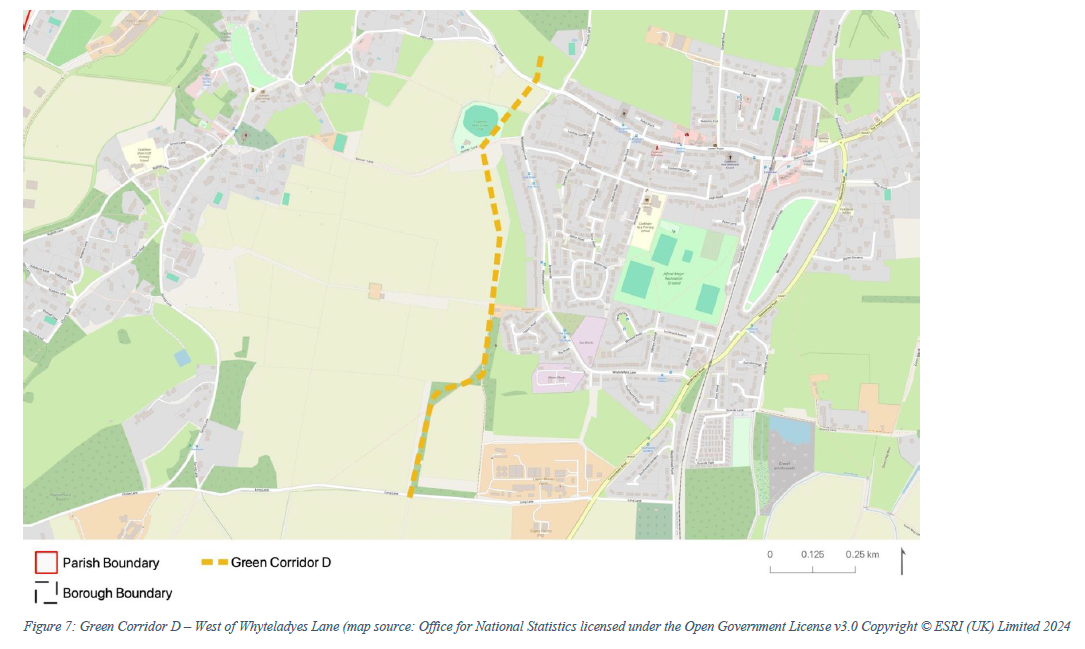
| D | West of Whyteladyes Lane | Hillgrove Wood (4) and Pigeonhouse Wood (6) | Woodland and gardens | Trees and hedgerow | Semi-mature woodland |
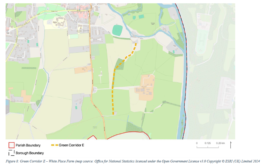
| E | White Place Farm | Sashes Island/Odney (5) and Battlemead (8) | Wet meadows, woodland | Trees and hedgerow | Meadows, wetland and woodland |
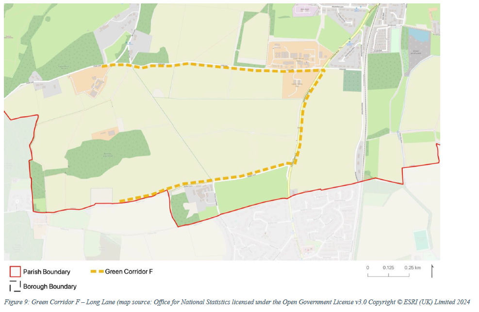
| F | Long Lane | Pigeonhouse Wood (6) and Beeching-grove Wood (9) | Woodland | Hedgerow | Semi-mature woodland |
| G | White Brook Strand Water Marsh Meadow | Widbrook (7)/Battlemead (8) and River Thames | Stream, ponds and wetlands | Stream and banks | Aquatic, amphibians, insects etc. |
| H | Malders Lane and Switchback Rd | Pigeonhouse Wood (6) and Beeching-grove Wood (9) | Woodland | Hedgerow | Semi-mature woodland |
Table 1: Green Corridors in Cookham Parish
5.9 The most obvious natural corridors through Cookham are (i) the railway line, linking waterway and wetland habitats around the river and the adjoining chalk grassland common land and providing a valuable wildlife route through the heart of Cookham, and (ii) the waterway leading from its outlet from the River Thames at Marsh Meadow along the Fleet Ditch and Strande Water through to the junction with Widbrook to create the Maidenhead Ditch. This stream links important habitats along its journey through to Widbrook Common and areas in North Maidenhead. Whilst these two corridors have a large degree of protection due to their inherent nature and location, there are other valuable but more at-risk corridors connecting wildlife habitats to the north and west of the Cookham settlement, notably the chalk grassland of Cockmarsh (ref 1, Figure 3), Winter Hill and the Bisham Woods Special Area of Conservation (ref 2, Figure 3) and the Local Wildlife Sites woods (ref 6 and 9, Figure 3). The corridors linking these facilitate wildlife movement via woodland and existing hedgerows, and importantly link to hedgerows providing routes between the higher ground of Cookham Dean and the floodplain.
5.10 Most of the green corridors in the Plan area consist of hedgerows with or without trees. The railway embankments along the line from Maidenhead to Bourne End have a very useful role to play for corridors, providing contiguous and uninterrupted semi-natural habitats.
5.11 Development adjacent to or surrounding these areas should help support the enhancement of habitats through a positive approach to conservation management.
5.12 As a general steer, where a corridor is shown as following a watercourse, its width would normally be considered to be around six metres on either side of the edge of the watercourse in line with guidance from the Environment Agency, extending to around ten or twelve metres where there are upslope pollution pressures. Where a corridor does not follow a watercourse, its width would generally be considered to be around ten metres. The width of corridors supports the uninterrupted migration of land-based species such as badgers, deer, reptiles and amphibians, but also enables the establishment of ‘stepping stone’ habitats to allow all species, including avifauna and insects, to migrate to larger corridor areas. Opportunities that help overcome current barriers to wildlife movement, including those created by the railway line, will be welcomed.
5.13 Information on planning for green infrastructure and wildlife habitats is set out in the Cookham Design Guidance and Codes. This shows how new (and existing) development might help create connected green corridors through:
5.14 Large parts of the Parish are at risk from fluvial and/or surface water flooding.
5.15 Though Cookham Village itself is on slightly higher ground, it is entirely surrounded by low-lying ground. This has the effect of isolating the settlement in all directions during flooding conditions, with the Causeway between Cookham Village and Cookham Rise the only means of access. It is thus important that this route is maintained to allow access at times of flooding (see Projects in Appendix 8).
5.16 The Local Plan, through Policy NR1 (Managing Flood Risk and Waterways), requires any development proposals situated on land designated as Flood Zone 2 or 3 to be able to demonstrate that an appropriate flood risk assessment has been carried out. The policy also notes that development proposals should incorporate Sustainable Drainage Systems (SuDS) in order to reduce levels of surface water run-off. SuDS are an approach to managing surface water run-off which seeks to mimic natural drainage systems and retain water on or near the site as opposed to traditional drainage approaches which involve piping water off site as quickly as possible.
5.17 The Construction Industry Research and Information Association (CIRIA) has produced comprehensive and technical guidance on the design and delivery of SuDS (C753: The SuDS Manual 2015).
5.18 The RBWM Borough Wide Design Guide recognises the value of SuDS not just in mitigating the risk of flooding, but also in contributing to a diverse and high-quality network of open spaces. Indeed, the use of SuDS can help contribute towards achievement of biodiversity net gain on development sites, as well as comprising a wider response to climate change and resilience. This may include the use of SuDS as ‘raingardens’ within the public realm as part of wider highways projects. These are generally low maintenance, wildlife-friendly spaces that manage rainwater runoff from hard surfaces and are also often referred to as bioretention facilities.
5.19 A range of design responses and SuDS techniques may be appropriate and can be explored through the design process. These include, but are not limited to, the use of permeable pavements, tree pits and planters, raingardens, swales, basins, ponds and rills. The integration of SuDS features on buildings can also be considered, including green/living roofs and walls, rainwater planters, water butts and tanks. Where SuDS features are proposed as part of the building, consideration should be given to structural safety and ongoing maintenance as set out in the CIRIA SuDS Manual.
< Previous | ^ Top | Next >