
The history of each of the wards, describing the particular attributes of properties in each
Beare Green – Introduction and Historical Context
Introduction
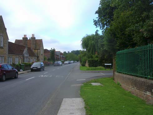
6.1 Beare Green enviably adjoins the Surrey Hills Area of Outstanding Natural Beauty and it is possible to take footpaths and bridleways from our village that lead one north, south, east or west into some of the most attractive countryside not only in the County of Surrey, but also in the whole of Southern England. It is also one of the few villages in rural Surrey that possesses a railway station with a train service leading directly to London or, via Horsham, to the South Coast.
6.2 Sadly, and in desperate contrast to these two extraordinary advantages, our settlement has been badly affected by the economic and environmental consequences that have been the common rural experience during the last quarter of the 20th century. Unfortunately, these changes for the worse have, in large measure, been compounded by a statutory planning regime and other strategic governmental initiatives that could so readily have served our community better. Essentially, these unsatisfactory outcomes are the result of a lack of vision.
6.3 Yet despite these difficulties, the spirit of Beare Green is thriving. Its population cares passionately about where they live and their surroundings.
Historical Context
6.4 To know its history is to understand Beare Green – and, through that knowledge, to appreciate quite why it evolved the way it has.
6.5 Taking its name from Walter de la Bere, a local landowner in the 13th century, the original hamlet of Beare Green lay in a clearing cut out of boggy woodland that stretched into Capel village to the South, towards the Holmwood to the North and was bounded by Newdigate to the East and Ockley to the West. The crude and impermanent dwellings of this small community were grouped around the village green ‐ now the playing field opposite the Weald School.
6.6 Until the middle part of the 18th century, travelling between Horsham and Dorking was virtually impossible during wintertime because the heavy and impermeable nature of the Wealden clay made roads and tracks into a quagmire. Even in summertime they were rough and rutted, making it difficult for local producers of goods and agricultural merchandise to gain access to the lucrative markets of the metropolis.
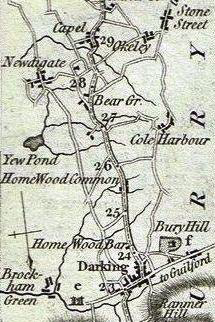
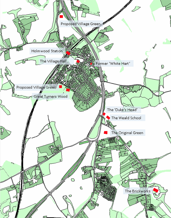
6.7 This sorry state of affairs improved markedly following the creation of a turnpike between Horsham and Epsom in 1755. The extract from the Carington Bowles ‘Direct Roads’ map of 1785 [see right], shows the route of the turnpike between Darking [sic] and Capel and the sparsely populated nature of the countryside between these two settlements. A second turnpike arrived in Bear Green [sic] some years later from the Okeley [sic] direction. The traffic on these roads was soon sufficient to encourage the establishment of a smithy at their junction and two inns to the North of it ‐ the Duke’s Head and the White Hart, respectively.
6.8 Visitors using these roads quickly recognised the beauty and quietude of the surrounding Surrey Hills. Soon, incomers started to buy and ‘gentrify’ erstwhile commoners’ cottages or farmsteads in the area, whilst the very wealthy began to build mansion houses.
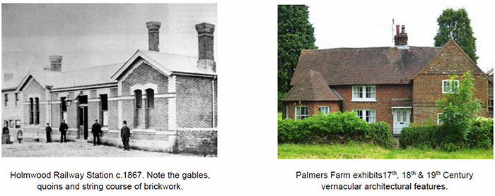
6.9 The coming of the railway and the opening of Holmwood station in 1867 acted as a catalyst for the speculative housing development to the South of the old village green and further encouraged the wealthy to settle in the area. From the outset, the railway service provided extremely efficient links to London and the rest of the country. Until the 1920s, the wider area around where the railway crossed the turnpike was known as ‘Holmwood Station’ and not Beare Green, which then referred specifically to the area around the original ‘green’.
6.10 Otherwise, the local economy was predominantly agrarian based, augmented by employment in the local brickfields, with a variety of small retail and service businesses attending to the needs of the inhabitants and their servants. Despite its rural location and small population, the basic infrastructure included a local school [just outside the Capel Parish at South Holmwood], a post office on the old village green, the public houses and various small shops.
6.11 As road transport developed after the First World War, Beare Green was found to be conveniently situated half‐way between London and the South Coast, leading to the expansion of the ‘White Hart’ public house, the construction of the ‘Red Arrow’ café opposite and a petrol station to accommodate the needs of the day trippers. All these developments were about half a mile to the North‐West of the original ‘green’ and much closer to Holmwood railway station. Meanwhile, land fronting on to the Newdigate Road and the Horsham Road was being divided into, typically, 1 acre plots for ribbon residential development.
6.12 The electrification of the railway in 1938, and its improved service1, added further impetus to this shift of focus and demand for new, albeit sporadic, housing development. During World War 2, the effects of the Blitz and the reliability of the train service to and from London made Beare Green a popular destination for those wishing to escape the bombing. This led to irregular “homesteading” in what is now Highland Road and Springwell Road.
6.13 As part of the ‘Greater London Plan 1944’, drawn up by Patrick Abercrombie in anticipation of post‐War regeneration, the general area around Holmwood station was identified as a potential area for metropolitan ‘overspill’ housing. However the refinement of the ‘Green Belt’ policy and the concept of the ‘New Town’ philosophy moved this proposed radical and extensive development to Crawley. Thereafter, housing development continued in a haphazard manner.
6.14 Meanwhile, the post‐war growth in road traffic led to increasing congestion between Dorking and Beare Green, especially on summer weekends. To alleviate this, substantial road works made the old turnpike, now the A24, into a high‐speed dual carriageway. Its design paid little heed to the existing communities along its route and the new “bypass” [sic] effectively severed all the settlements either side of it from each other.
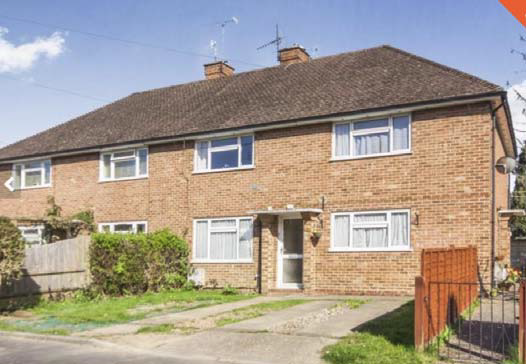
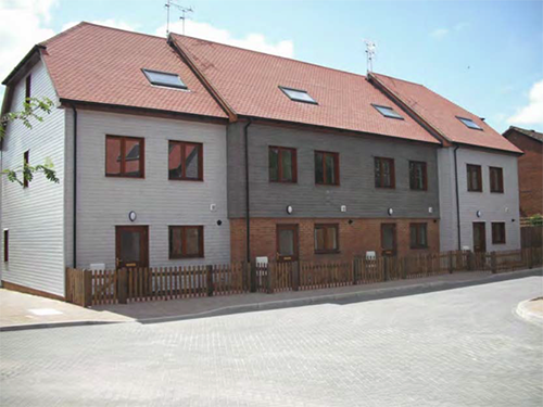
6.15 During the last four decades of the 20th century there was a rapid sequence of house‐building on both ‘greenfield’ and ‘brownfield’ sites or on backland created by the A24 road improvement works. Since 2000, the rate of new housing has decreased, although in 2013 Godwin’s Nursery closed and its site was developed for further housing to form Breakspear Gardens. This site provided 23 dwellings, including affordable housing. It is North of the railway and in the Green Belt.
6.16 Much of this new development has many of the characteristics of a suburban‐style estate. When coupled with the closure of a local primary school, a public house and the post office (all were sited to the West of the A24 dual carriageway), this makes the consideration of the needs of this part of Beare Green significantly different to those of more traditional villages, including Capel, which have evolved over centuries and have retained their social and day‐today service provision within their communities.
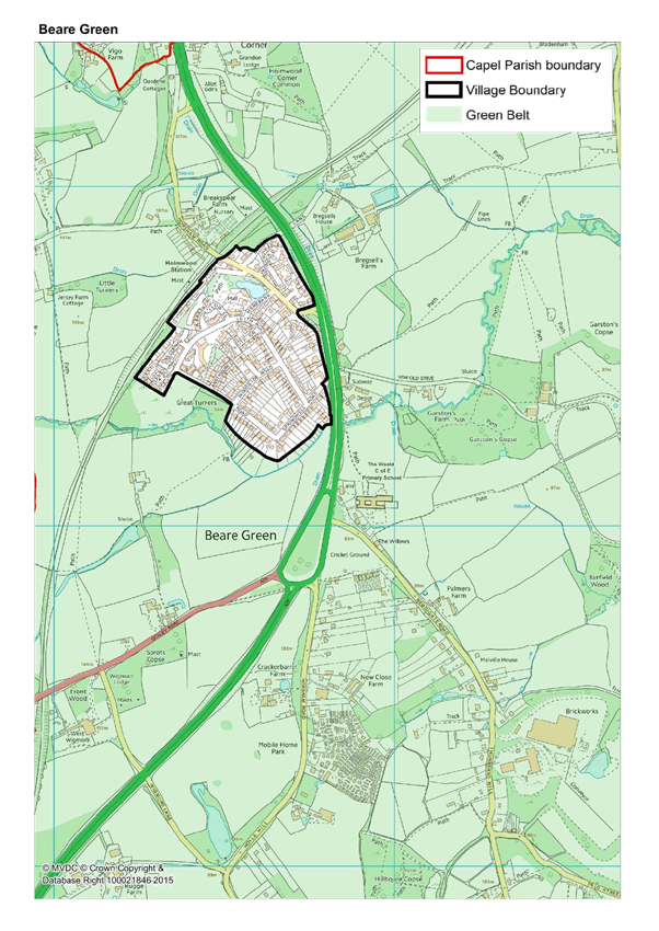
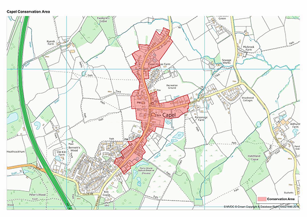
6.17 To help simplify and organise this description, Beare Green ward has been divided into four ‘Character Areas’ – see pages 41‐42 of The Landscape and Visual Sensitivity Appraisal prepared by CSA Environmental, which follows this section. For ease of reference, these Character Areas are:
Beare Green Asset Map
A Village Divided by a Road
6.18 So, in 2016, the main settlement of Beare Green now comprises some 400 houses, a cluster of businesses and a village hall sitting to the West of a 4‐lane highway that divides it from the pub, the school [built in 1940], the original green, about 100 older houses, the Surrey Hills Hotel and 120 mobile homes [in 2 parks on Horsham Road], that lie to the South and East.
6.19 Far from being a bypass, the A24 actually bisects the village and prevents easy pedestrian access to resources. This causes a further reliance on the use of motor vehicles and exacerbates an existing accident ‘black spot’. Recent reductions in the speed limit from 70mph to 60, and now to 50mph have made little difference to the noise or the potential danger.
Future Vision and Core Objectives
6.20 This village plan for Beare Green aims to:
6.21 A “sustainable community” is defined [see Glossary attached to the DPD Core Strategy, at page 97] as a place:
“... where people want to live and work, now and in the future. They meet the diverse needs of existing and future residents, are sensitive to their environment, and contribute to a high quality of life. They are safe and inclusive, well‐planned, built and run, and offer equality of opportunity and good services for all. For communities to be sustainable, they must offer:
People also need open public spaces where they can relax and interact and the ability to have a say on the way their neighbourhood is run.”
6.22 Beare Green has many of these features, but not all of them. So this Neighbourhood Development Plan seeks to fill those gaps and provide the long‐missing direction.
Priorities:
Beare Green Village Hall
Heritage and Conservation
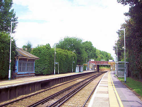
6.23 There is only one listed building in the main Beare Green settlement, to the West of the A24: the signal box on the up platform of the railway station.
6.24 There is no conservation area, but the Beare Green settlement area abuts to the Surrey Hills Area of Outstanding Beauty and is inset within the Green Belt.
6.25 Great Turners is ancient woodland.
6.26 However, whilst the Beare Green ward has a paucity of assets given official notice or specific listing, it does not follow that protection and enhancement should not be afforded to features that reflect its heritage. Obvious examples include:
Social (including Leisure and Recreation)
6.27 As Beare Green has evolved, little consideration seems to have been given to its social or its spiritual needs.
6.28 The isolation of ‘The Duke’s Head’ public house by the construction of the A24 dual carriageway has made it much less ‘local’, whilst the ‘White Hart’, both a pub and a music venue, was demolished to make way for further housing.
6.29 The newer Beare Green development has only had a brief encounter with the Roman Catholic Church. After its closure, their idiosyncratically designed church building was sold to Mole Valley District Council and let to the Beare Green Community Association for use as an unlicensed village hall after some very minimal adaptation. The Parish Church of St Mary Magdalene lies a mile to the north, in South Holmwood.
Beare Green Court
6.30 The Beare Green Community Association works hard and is regaining ground, particularly now that it has successfully managed to renovate and extend the village hall. In addition to managing the village hall, it runs social events throughout the year.
6.31 The compact retail development at Beare Green Court provides another focus where pedestrians may meet and interact.
6.32 Although many people throughout Beare Green mainly socialise with friends and family within their own homes, there are numerous social events at the Village Hall, including the reading group, mothers and toddlers, knitting, exercise groups and a new youth club. People in the village also travel further afield for social interaction, e.g. the Capel WI or the Camera Club as well as football, cricket and bowls clubs in neighbouring villages, although football and stoolball matches do take place on the Village Green opposite the Weald School.
Social Networks
6.33 There are various community networks, all of which need developing in Beare Green for these groups:-
6.34 Approximately one third of the residents live alone, a higher proportion than the Mole Valley average. This suggests that a higher than average number of adults will consider the village to be the priority network to which they belong. Additionally, Beare Green is typified by an ageing and divergent society, which is not only sharply polarised between the prosperous and the barely coping, but also not bonded together by access to any place where meeting can happen on equal terms.
Social Infrastructure
6.35 There are two ‘parallel universes’ in the village ‐ those that live there during the day and those that return in the evening. However, there are few community or social activities that allow them to meet or become involved, either within each grouping or as a whole.
‘This Side and the Other Side’
6.36 The road is an unsafe barrier and as a result the area on the east side of the A24 is sometimes described as ‘no man’s land’. Those who live there tend to be affiliated to Capel or Newdigate. How can they be encouraged to interact with Beare Green village to improve neighbourhood inclusivity?
The Relationship of Beare Green to Capel Civil Parish
6.37 Over a century ago, when Beare Green was just a hamlet surrounding the Green, it made sense to link it to Capel village for local government and funding purposes. Hence the civil “Parish of Capel” was created with three wards: Beare Green, Capel and Coldharbour.
6.38 The civil Parish of Capel should not be confused with the Church of England Parish of St Mary Magdalene, which also includes Beare Green within its boundary.
6.39 The recent growth of Beare Green, leading to it being the major contributor to the precept that funds the Capel Parish, the divisive effect of the A24 dual carriageway and the perception, stemming from the name of the civil Parish being taken from Capel village, that Beare Green is the ‘poor relation’ has sometimes led to a strained relationship between Beare Green residents and the Capel Parish Council.
6.40 Recently, however, stronger representation by Parish councillors from the Beare Green ward coupled with more co‐operative working with representatives of other wards and within the Parish Council itself is starting to show some mutually beneficial results.
Enabling a Sense of Belonging
6.41 This can be achieved by:
6.42 That said, there is already a strong sense of community especially when there is a threat to the area such as large scale housing development, the recently proposed solar farm, aircraft noise, etc.
6.43 With recent funding derived from the building of Breakspear Gardens and other sources, a community effort has revamped the Village Hall and created a better use of the existing space that is already being used to great effect by newly formed activity groups from within the village. This work is set to continue.
6.44 There is a well‐used playground for children of all ages next to the Village Hall. The original Green on the eastern side of the A24 has a football field, a sports pavilion, swings for smaller children and outdoor gym equipment.
6.45 There is also further potential within Beare Green for other green areas to be created that will increase the usable space for children in all parts of the village and for dog walkers, joggers etc. This can be achieved by securing the land in Highland Road (BG06) and creating a green on the land to the north of Breakspear Gardens (BG03). Together with the original Green, both of these new green spaces will be given the protection of ‘Village Green’ status.
6.46 Wherever possible, access to and between these various green spaces will be by a ‘necklace’ of pedestrian and bicycle‐friendly routes away from vehicular traffic.
6.47 All these items are referenced by “Policies” later in this document.
6.48 This Neighbourhood Plan can, through careful and controlled development, become the catalyst for further improvements to the Village Hall and other community facilities, as well as other projects designed to enhance the appearance of our village and the enjoyment of the natural delights to be found in and around it. However, this can only be achieved with public consent and backing.
Economics and Employment
6.49 The village is populated by a diverse range of residents who are variously retired; semiretired; self‐employed working from home; working outside the village in various trades; working outside the village in professional and managerial positions or undertaking voluntary work on an unpaid basis.
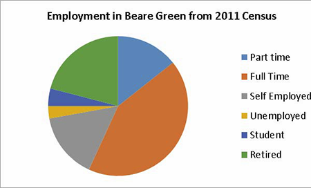
6.50 There is employment in the village, but a high proportion of residents travel away from the village to work.
6.51 A comparison of local and national data indicates that Beare Green contains a higher proportion of self‐employed people compared with the national average of 19% and a lower proportion of those still studying.
6.52 The larger employers in Beare Green are the school, the brickworks and Burleys grounds maintenance, but under the surface are many other small businesses being carried out in homes, back gardens and small premises.
6.53 In Beare Green, over 100 businesses have been identified ‐ see the list of business and table of employment types. This isn’t so much the ‘Invisible Economy’ as the ‘unnoticed economy’, vital to the strength and sustainability of our village.
6.54 The Neighbourhood Plan should attempt to provide starter business units within the parish. These must have good broadband connectivity and be available at a reasonable rent. Existing businesses and employers should be encouraged to stay in the area through improved facilities and desirable/suitable housing, thereby responding to the objectives of sustainability.
6.55 Some residents are able to receive “superfast” broadband (fibre to the cabinet). However, despite the connections being made, it seems capacity is severely limited and many residents who wish to connect to this improved service are unable to do so. Accordingly, communications companies are encouraged to complete this roll out with greater alacrity and to offer other connections in this area. This is vital, not only for business, but also social use, entertainment etc.
6.56 In contrast, cellular reception is generally excellent. Double speed 4G data connections available (from at least one company) in some parts of Beare Green, whilst 3G and 4G are general available (from several companies) inside homes.
Population
6.57 The population of Beare Green has increased slightly during the 10 years between census points, from 859 households in 2001 to 863 in 2011 ‐ or from 1500 residents to 1800 residents.
6.58 Population density is 250 people per square kilometre. This is below the corresponding Mole Valley figure of 334 or the UK average of 413.
See: http://www.neighbourhood.statistics.gov.uk/HTMLDocs/dvc134_c/index.html
6.59 The population of Beare Green, as a whole, is slightly older than the national average.
6.60 The number of 18 to 45 year olds is slightly lower and the number aged 45 and over is higher.
General Health Statistics
6.61 The respondents to the 2011 Census were asked to rate their health.
6.62 The percentage of residents in Beare Green rating their health as 'very good' is higher than the national average.
6.63 The percentage of residents in Beare Green rating their health as 'very bad' is lower than the national average.
6.64 This evidence suggests that the health of the residents of the area is generally better than in the average person in England.
6.65 These population and health statistics lead to the conclusion that pedestrian access to medical facilities is a desirable component for this plan.
Crime
6.66 Crime is comparatively very low in the Beare Green area.
6.67 On average, around 10 crimes are reported to the police per month. They include making away without payment at the petrol filling station, domestic and neighbourly disputes, theft, burglary and vehicle crimes.
Village Environment
6.68 Typically, a village would generally be considered to be a collection of houses around a green or centre, with a Pub, a small shop and Post Office, a place of worship, a small school but it also has a lifestyle characterised by clubs, societies and activities including leisure and work. Additionally, a village is likely to exhibit most, if not all, of the following attributes:
These qualities, that shape the identity of a village, often take six or seven centuries [or more] to evolve and develop6..
6.69 As most of Beare Green, as it currently exists, has grown up since the Second World War, effectively it has only had six or seven decades [rather than centuries] to establish its own village identity. Whilst considerable progress has been made in that time, clearly there is still much to be done.
Housing
6.70 Beare Green has an eclectic mix of housing, ranging from suburban‐looking areas, mobile home parks and large detached houses, all set amongst open fields and woodlands.
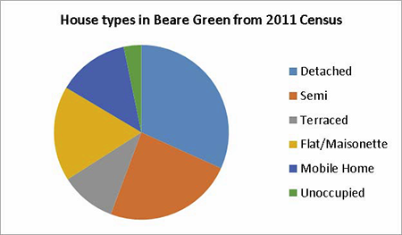
6.71 From the evidence contained in the Housing Needs Analysis Report commissioned for this Neighbourhood Development Plan, the consensus is that Beare Green is well stocked with homes of all categories, yet young people are still unable to afford to live here. (See Appendix F)
6.72 In addition there are not enough affordable homes or bungalows for older resident wishing to downsize.
6.73 Within Beare Green, there is a willingness to allow some limited development but only if it helps with the provision of affordable homes. The priority must be given to those who live or are associated with the local community.
Education
6.74 The Weald School was originally opened in 1940 as the Beare Green Church Central School. Then, it catered for pupils aged 9 to 14 and taught skills that would lead them to employment.
6.75 Currently, The Weald Church of England Primary School has approximately 280 pupils, aged from 4 to 11. It is set in 17 acres of grounds and playing fields. It is an academy in the Good Shepherd Trust.
6.76 The Weald School has always been allied to the diocese of Guildford and the current Chairman of Governors is a Canon of Guildford Cathedral.
6.77 This Neighbourhood Development Plan recognises the need for safe pedestrian and cycle routes between housing and schooling, together with a reduction of parking and traffic congestion in Newdigate Road at school starting and finishing times.
Transport
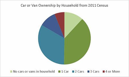
6.78 Only 12 % of homes in Beare Green have no car or van and over 50% have 2 vehicles or more. Clearly private road transport forms a vital part of the lives of its residents.
6.79 The A24 and A29 provide excellent communication north and south, to the major towns of Horsham or Dorking, and beyond.
6.80 More minor, and often narrow, roads lead to Crawley, Gatwick Airport, Guildford and surrounding villages.
6.81 But this easy access comes at a cost: danger, noise and other pollution. This is not only from specific vehicles and speeding motor cycles but also in the form of an omnipresent ‘white noise’.
6.82 Beare Green also has a railway station ‐ Holmwood. Only about 10 rural villages in Surrey have such a facility. It is a great asset and is especially useful for residents employed in London or for those without a car.
6.83 Residents request more frequent rail services particularly in the early evening and at weekends.
6.84 The railway is still used by those wishing to walk in the Surrey Hills and several ramblers’ websites recommend walks that use Holmwood station as a starting point. Before World War 2, the train service was regular and ran seven days a week – even the station sign read, “Holmwood for Leith Hill”. Today the current patchy weekend service from the station, means this resource is significantly under‐utilised. Neither Network Rail nor Southern, the train operating company [part of Govia Thameslink Railway], show any desire to improve this situation.
Holmwood Station
6.85 In the 1980s, trains took 47 minutes for the journey from Holmwood to London Victoria [and vice versa]. Today it takes over an hour, at best. This is a direct consequence of privatisation and the desire to avoid fines for late running – even if it means waiting several minutes at Dorking, Epsom or Sutton for ‘time’.
6.86 There has been a recent investment in new rolling stock and many trains serving Holmwood in the peak period are now 10 coaches long, rather than 8 (see Appendix K).
6.87 Beare Green is served by the No. 93 bus service that runs between Dorking Railway Station and Horsham Bus station..
6.88 This bus service is approximately hourly and runs seven days a week. However, the last bus in either direction is comparatively early in the evening, so it is not possible to have a night out in either Dorking or Horsham using this service.
6.89 Like Capel village, Beare Green is geographically close to Gatwick International Airport.
6.90 There is little or no provision for cycle routes, and access to The Weald School whilst available via a pedestrian underpass is considered unsafe by many. This is slightly ironic considering the closeness to Beare Green of the Surrey Cycle Paths and the regular road events that take place through our Parish.
6.91 This Neighbourhood Development Plan encourages the creation of safe walking and cycle routes, opportunities to make it easier and safer to park motor vehicles at Holmwood railway station and elsewhere and actively promotes the use of all modes of transport, other than the motor car. And yet we must facilitate the users of motor vehicles and ensure any new schemes have more than adequate parking provision.
Summary
6.92 Beare Green’s Key Assets:
6.93 What Beare Green Lacks:
6.94 In addition, as part of the Neighbourhood Development Plan consultation the Beare Green residents have raised the following issues:
6.95 One gratifying aspect that has become apparent during the Neighbourhood Plan process is the willingness of Beare Green residents to engage in discussions about the area. In particular they have indicated that they:
6.96 What is feared are large, low quality and ill thought‐out housing schemes and the destruction of hedgerows and green spaces. There is also widespread concern about the destruction of the Beare Green “views” and green setting. A well‐constructed Neighbourhood Development Plan, however, can allow for small developmental changes without detriment to the overall character of Beare Green.
6.97 The concept of extra housing is basically accepted (especially low cost or affordable homes) but the details of developments are of very serious concern indeed. Such anxieties include the overall appearance, the number of dwellings, the maintenance or enhancement of the rural vistas and the rural approach to the village. Ensuring that parking challenges, drainage issues, and landscape concerns are properly addressed is also vital.
6.98 Providing social, health, vehicular and non‐vehicular transport improvements are also key requisites.
6.99 Beare Green is a community seeking improvement. In its effort to catch up with the rest of Capel Parish, it is in need of a catalyst for change: which this Neighbourhood Development Plan can provide.
Character and Identity – Beare Green
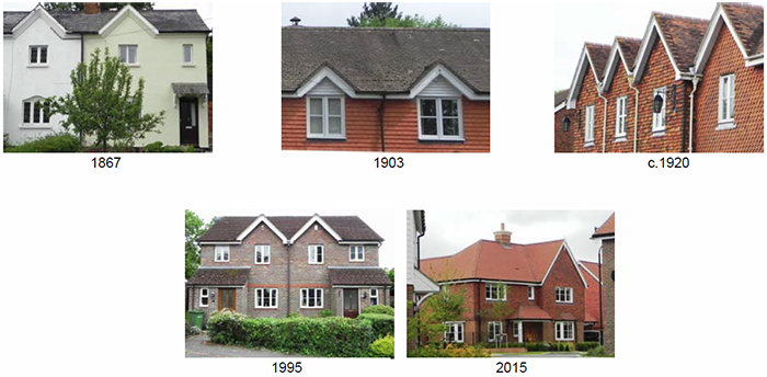
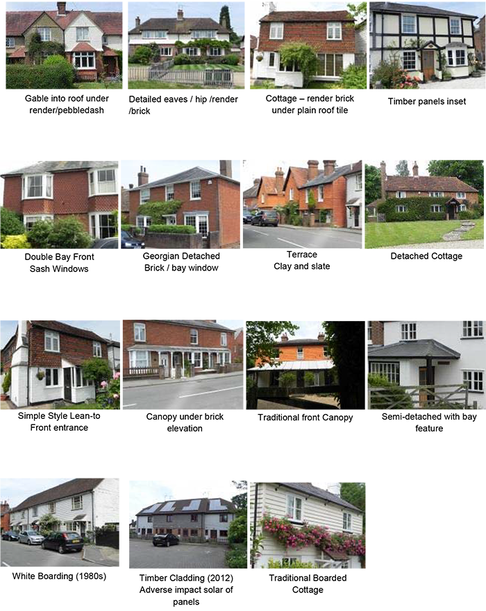
In contrast to Capel or Coldharbour, which have developed the identities of their built environment over centuries, house construction on any major scale in Beare Green has only taken place since the Second World War. On the face of it, this might suggest that there is no prevailing vernacular architectural style or character in the settlement. Moreover, several valuable sources have been lost through fire (Bregsells Farm), wanton demolition (the railway station) and re‐building (the original Georgian lines of the former ‘White Hart’ public house disappeared in the 1920s).
Yet, by a careful analysis of what few buildings remain, notably Palmers’ Farm and various groupings of cottages, or the use of old photographs, it is possible to discern vernacular detailing that has been carried on through the years and is still being incorporated into modern developments. This study is reflected in the design brief that follows.
WALLS
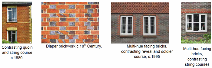
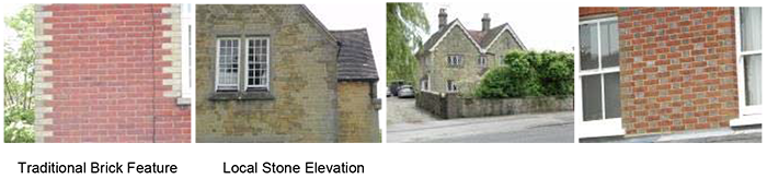
Brickwork Elevations are predominately brick. Facing bricks in Beare Green show a wide variety of colour and are often multi‐tone. Simple detailing is often found, including string and soldier courses, with the occasional use of contrasting quoins.
Render
This has limited use, usually on older dwellings. Occasionally painted brickwork or pebble‐dash render is found, again on older buildings, with white and cream colours applied. These finishes are generally inappropriate for new work and facing bricks should be used.
Tile hanging
Sensitive and restrained use of tile hanging is used extensively in Beare Green. New work should reflect local features.
Boarding, Heads and Cills
When boarding is used, it is stained or painted white and hung horizontally. New work should follow this tradition.
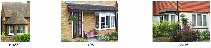
White timber cladding 2015
Close inspection of the photographs in this review shows typical window opening, head and cill features in Beare Green. These should be reflected in new work.
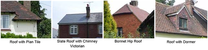
ROOFS
Pitches
Steep, not normally less than 35‐50°
Materials
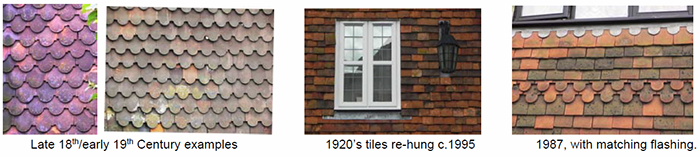
Small scale. Mainly plain tiles with matching ridges and bonnet hips where used. There are examples of simple slate roofs on older buildings and occasional use of artificial slate on modern buildings for variety.
Eaves and Barge‐Boards
Simple detailing frequently with closed eaves, although sometimes with exposed rafter feet and clipped verges are found. Roofs tend to be simple in shape and form. No large overhangs.
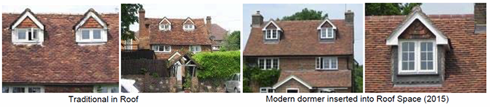
Dormers/Velux Windows
These should be neat, sharp and simple in form.
Normally they are smaller than the windows in the elevation beneath. Velux windows should not alter the character of the roof and therefore their size should be restricted appropriately.
WINDOWS
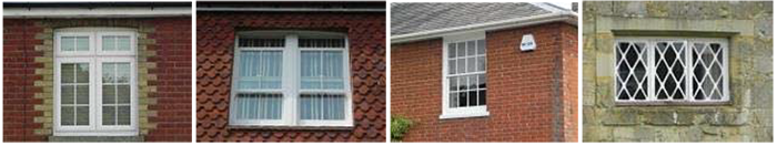
Style
Three main designs are evident:
Where replacement windows have been fitted they normally match the previous pattern. Windows are virtually exclusively white in colour.
DOORS
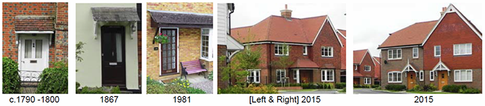
Style
Traditional stained or painted timber country doors in white painted frames, normally without side lights. Photographs in the Storm Porch section of this review [below] show typical examples.
FEATURES
Most houses are simply proportioned, with uncomplicated detailing and relatively steeply pitched roofs.
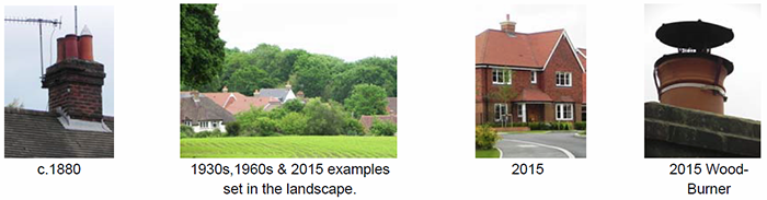
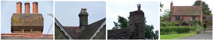
Many houses feature chimneys and chimney pots with a wide variety of styles from simple brick pillars to quite detailed and ornamental chimneystacks.
A wide variety of storm‐porch designs are used from simple cantilevered shelters to more sophisticated approaches with supporting posts.
Bay windows are a feature in some dwellings.
Decorative gables have been used in Beare Green for many years. They particularly suit semidetached pairs of dwellings.
Throughout Beare Green, dwellings are generally set back from the roadside kerb or the back edge of the pavement. The frontage of the plot is defined by dwarf brick walls, picket fencing or indigenous hedging (but no fencing), giving variety to the streetscape.
Buildings, Height and Massing
Buildings are generally two‐storey, or two and a half storey, or three‐storey.
Continuity and Enclosure
Spatial identity is reinforced by low walls, fences and hedges which provide a continuity of the built form.
To give to strength to the identity of the built environment in Beare Green and to aid legibility, the various vernacular features described above should be incorporated into the design of new dwellings and any required Design and Access Statements.
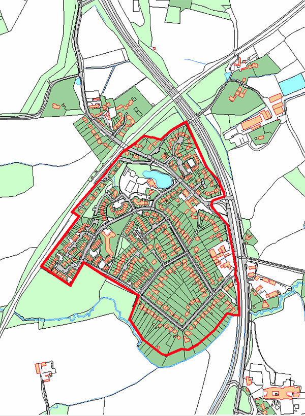
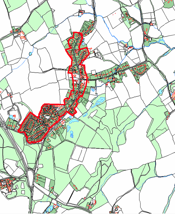
Figure 10 – Plan illustrating existing village settlement boundary for Beare Green
Capel – Introduction and Historical Context
1. Introduction and History
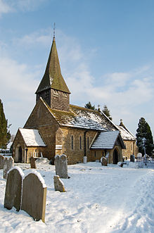
1.1 The Parish of Capel consists of three villages that have grown through the centuries to accommodate residents occupied in a variety of jobs, both locally and further afield, and dwelling in a village environment. Capel itself started as a settlement of farms and developed into a village spreading from north to south in a linear structure which at one time had several shops and inns and a coaching station as well as a variety of dwellings. An early 12th century document was the first to mention a “chapel of ease” (Capella) within the Parish of Dorking and this gave the village its name. Around 1334 the chapel was upgraded to a church and after Cromwell abolished holy and feast days in 1536 the church became known as St John the Baptist of Capel.
1.2 In 1279 John de Elfold granted lands in Capel to the Knight Elfold and by 1308 the tenancy of Temple Elford was taken over by the Knights of St John of Jerusalem who stayed over two hundred years.
1.3 The village has greatly changed and developed over the last fifty years creating more accommodation of two/three and four bedroom houses to satisfy the growing families and the need for their own homes. This has given the village a challenge to find space to build more homes and fulfil the need for a variety of homes, including affordable homes, flats, bungalows and small housing whilst also giving those who require larger accommodation the opportunity to increase the size of their homes to meet their needs.
1.4 There are many well‐known families and names that have become entrenched in the village such as the Bax family of Pleystowe who were Quakers. The present Friends Meeting House was acquired in 1724 and still is a feature of the heart of the village.
Other names include yeoman farmers:
Some other old family names became an important part of the fabric of the village ‐ Mortimer, Wigmore, Carterdale (Carters and Dales); Bennetts Wood (built in 1952), Broadwood Cottages (1947), Markham Park (1981‐1988) and Grenehurst Park (1990).
1.5 It is the desire of the residents of Capel to allow families to spread across the village without having to move elsewhere by permitting a variety of accommodation to be built that will provide facilities that suit all tastes with the assistance of various agencies, housing associations and local authorities, all assisting in making space for those who wish to remain in a rural environment. Markham Park has provided a variety of accommodation: 1‐bedroom, 2‐bedroom, 3‐bedroom and 4‐ bedroom houses, including a number of affordable homes to accommodate the growing numbers of Capel residents. Markham Park was completed in 1988 and is a popular area with families. A benefactor who lived in Capel donated a piece of land to the village for young families to be given the opportunity of shared‐ownership accommodation and Nunn’s Field was created for a number of families. This was much appreciated by local residents.
2. Housing, Employment and Services
2.1 Following the departure of a local employer and business closure, land in what is now Laundry Way became available. A local Housing Association in 2011 built a variety of homes, two and three bedroom houses and flats, to accommodate local residents who did not have anywhere to live. Although this resulted in loss of employment land it filled a gap in the accommodation market.
Laundry Way
2.2 Transport – Public transport supports those who do not have their own cars or who are no longer able to drive. Some years ago there were three different bus services running through the village but with the advent of higher car ownership this has now been reduced to one. There is also now a community transport service, Capel Assist, which is run by volunteers and takes residents to hospital and doctor’s appointments and school buses serve families with children attending certain schools during term times.
Bus Service
2.3 The number 93 bus service runs 7‐days a week between Dorking and Horsham with several bus stops in Capel supplying residents with the opportunity of using a service which has undoubtedly improved over the last few years and currently runs from early morning into the early evening. However, residents are not able to use the bus service if they wish to spend the evening away from the village and must rely on private transport.
Railway Service
2.3 What is today known as Ockley railway station started life as “Capel and Ockley” when it opened in May 1867. At that time there was a substantial volume of traffic from the two local brickworks, as well as milk transport which only ceased in the 1930s when road transport took over. In the 1980s Capel was dropped from the title and the station became known as Ockley. The rail service is a popular form of transport and is valued by commuters as a speedy and safe means of travel. The car park at Ockley is now being extended and consideration is being given to provision of a footpath from Capel to the station for those wishing to walk to the station.
Footpaths & Bridleways
2.5 Regular users keep a watchful eye on paths and bridleways to ensure that they are kept clear of vegetation and sightlines are maintained. Many residents ride bicycles and horses through and around the village and will often ride from one village to another as a form of recreation.
3. Community Infrastructure
3.1 Residents wish to maintain the separateness of their village from neighbouring villages but there is a need to ensure ease of movement between the village and local areas to enable access to schools, workplaces, medical facilities and shops using public transport that matches their needs.
3.2 Schools:
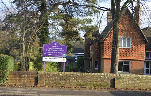
Capel Pre‐School and Scott‐Broadwood C of E Infant School. Head Teacher Susan Muat. A sister school also known as Scott‐Broadwood C of E Infant School is situated at Ockley and is served by the same Management Team as the Capel School.
3.3 The village is well‐equipped with two halls for the community to use for activities, clubs, groups and public meetings. The original hall, which fronts onto The Street, was built in 1912. Following the First World War it was renamed Capel Village Memorial Hall as a reminder of the local residents who gave their lives in that war. In 1956 the building was extended, incorporating a kitchen, toilets and a committee room, opening up the facility to many further possibilities. The Memorial Hall is now run by a Management Committee which ensures that the Hall continues to reflect its importance to the community. Recently refurbished alongside the Memorial Hall is the Parish Community Hall which was formerly the Youth Centre. The building also contains the Capel Parish Council office. This new Hall is also available for use by the whole community as well as the youth club which is now under new management.
4. Local Activity Groups
4.1 Clubs – There are numerous clubs and activities in Capel: Badminton, Bridge, Camera Club, Cricket, East Village Book Club, Local History, Football, Guides & Scouts, Beavers & Cubs, Rainbows, Tennis, Stoolball, Lunch Club, WI, Horticultural Society, Choral, Evergreens, Walking, Men’s Group, Mothers & Toddlers, Quakers, Allotments, Capel Assist, Flix in the Stix, St Catherine’s Hospice, Art, Youth Club, Young Farmers etc Each August the very popular Capel Show takes place on the recreation ground. This is organised by the Horticultural Society alongside the Classic Car Show followed by the Music Festival. Earlier in the year the Military Vehicle Show takes place in the village.
4.2 Church – St John the Baptist Church provides a wide variety of activities for all age groups from toddlers to Bible Reading, Messy Church and Bell Ringing. The Church provides popular Sunday afternoon teas during the summer months and is a very welcome relief to ramblers and walkers and the local community. All cakes are made by generous members of the local community.
5. Employment
5.1 The Doctors’ Surgery – Serving the villages of Capel, Beare Green, Ockley and Coldharbour.
5.2 Shops – A general store selling groceries and other provisions and a second general store that also has a café, a Post Office and forecourt selling fuel.
5.3 Businesses – There are many businesses attached to Capel giving employment to the local community – the Pub, Car Care, Tree Surgeon, Music lessons, Eco Logs, Removals, Electrical, Car Hire, Clock Repairs, Horse Riding, Harness Maker, Bakers.
6. The Community
6.1 As Capel village grew over the years the road through the village became unsuitable for the continuous heavy traffic that used this small narrow road on a daily basis. The road was an arterial road from London to the coast at Worthing. In 1930 a petition was set up to move the volume of traffic from the heart of the village. However, the proposal was not finally agreed until the 1980s and the by‐pass was finally completed and opened in 1982.
6.3 The historic centre of the village includes the church, shops, school, pre‐school, pub and several other businesses. At one stage there were in the region of 10 pubs stretching across the village. Today only one pub remains to serve the community with all the others now turned into dwellings.
6.4 Before the First World War there were many attractive and well used shops all gradually sold and now turned into attractive dwellings and admired for their architectural attractiveness to the village street scene. Now there are only a few retail businesses left but they serve the community well and supply a wide variety of provisions and services.
6.5 Farming activity has reduced over the years and there are only a few farms now which provide food for the community. Some farms are arable and sow crops for animal feed and there are still some where sheep and cows are kept for meat, hides and milk.
7. Environment
7.1 There is a Nature Reserve in the village which is enjoyed by ramblers, walkers and horse riders.
7.2 Residents wish to retain the rural village ambience and keep the green feeling throughout the village and its surrounds by preserving the green belt as well as nearby Areas of Outstanding Natural Beauty (AONB), Sites of Special Scientific Interest (SSSI) and other areas that are loved and enjoyed by all.
7.3 These aims are recognised as essential and demonstrate the need to maintain the village environment as a comfortable open and pleasant place to live.
8. Village Objectives
8.1. To reduce the speed of vehicles through the whole length of the village, particularly at busy times of the day and especially near the school, shops, garage forecourt and the T‐junction.
8.2. To increase the number of affordable dwellings by considering the suitability of sites in Vicarage Lane, Coles Lane and outside the curtilage of the village.
8.3. To ensure that footpaths, bridleways and byways are kept in good condition for walkers, cyclists and horse riders.
8.4 To increase recreational facilities, concentrating on open spaces for playgrounds for small children and sports facilities for all ages to use for their various activities.
8.5. To encourage new businesses to come to the village by considering suitable sites around the village that do not encroach on domestic accommodation.
8.6. To consider ways of improving public transport. If the buses and trains ran later in the evening this would encourage more people to leave their cars at home and use public transport.
8.7. To look at use of land and farming today and what can be done to encourage continued use of farming land, keeping livestock, and using the land to its full potential.
8.8 To retain all that is good about present life in the village and carefully consider and plan how we want the village to look and feel for future generations of residents.
Character and Identity – Capel Village
Buildings, heights and massing
Styles
Roofs
Pitches not normally less than 35 degrees to 50 degrees. Mainly plain with some bonnet hip features
Dormer Roof Features
Windows (see also door styles)
Three main designs:
Casement with small panes and leaded lights
Casement with larger panes
Double hung sliding sashes
Walls
Brickwork has simple detailing with some pantile brickwork. Use of local stone adds to village character
Chimney Styles
Many traditional cottages and houses feature chimneys or chimney pots with a wide variety of styles both simple brick pillars to ornate stacks
Features which create a village street scene
Enclosure is achieved by tight building, hedges, low walls all located close to the street edge
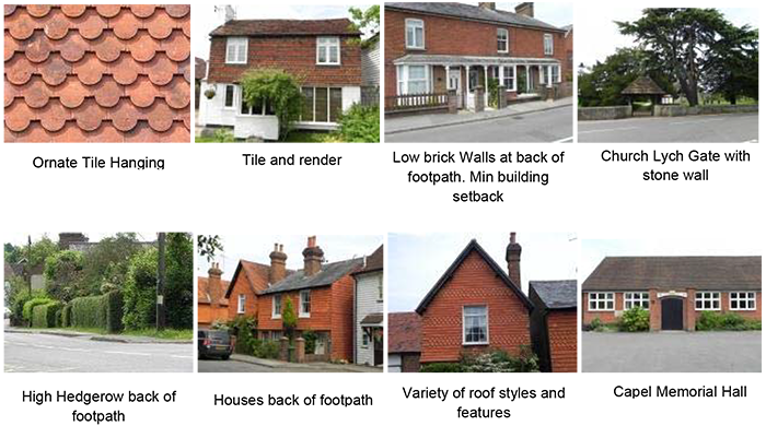
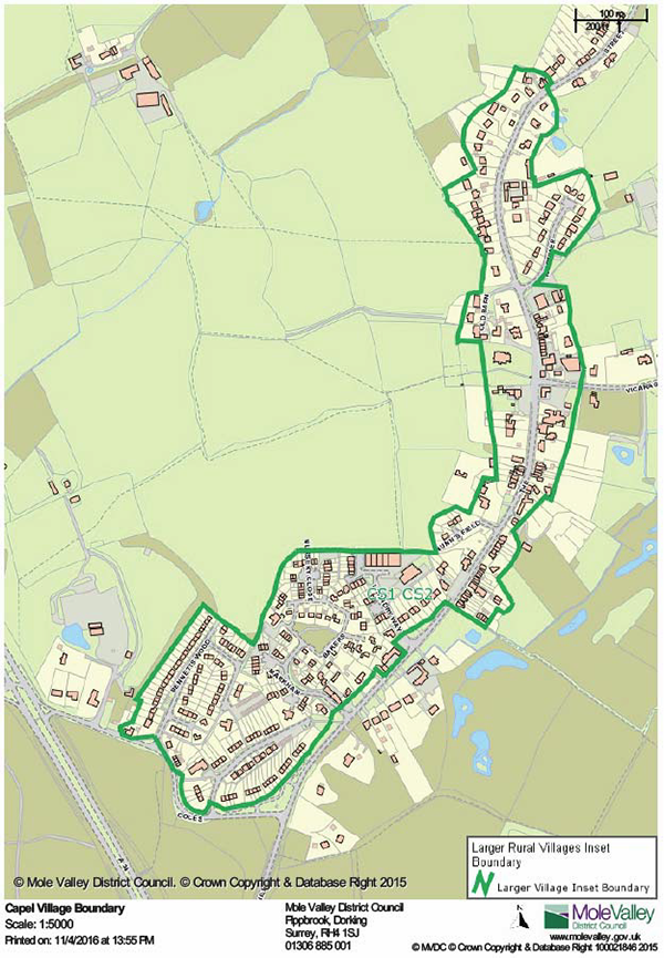
Figure 11 – Plan illustrating existing village settlement boundary for Capel
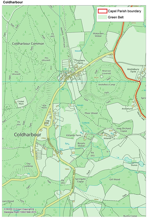
Coldharbour – Introduction and Historical Context
For those of us who are lucky enough to live here, Coldharbour is a wonderful village and the location is just idyllic. It is therefore essential to villagers that we conserve and enhance the unique character, tranquillity and charm of this place for those who live here now, for those who move here in the future and for those who come to visit and enjoy this enchanted part of Leith Hill.
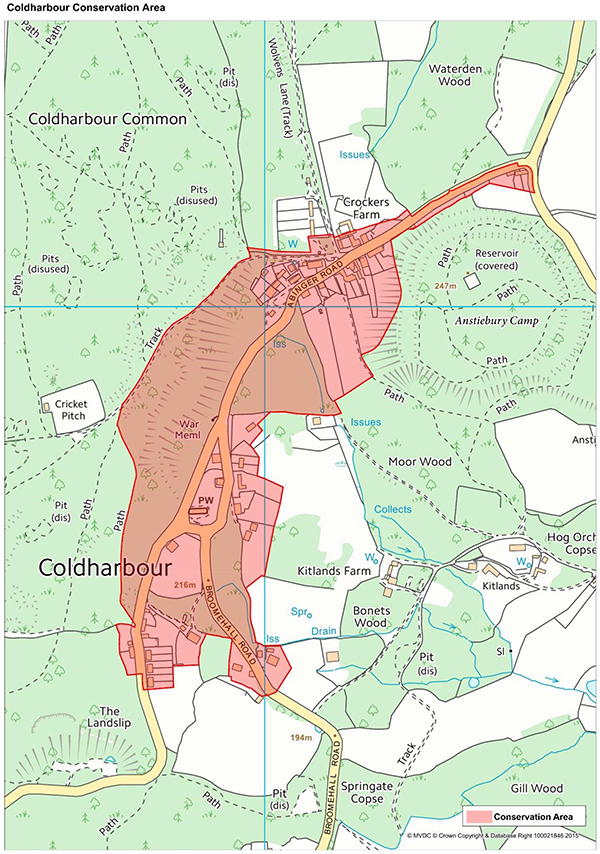
Coldharbour comprises around 150 dwellings, with a settlement where the properties are spread along narrow meandering country lanes, mostly built on sand and clinging to the steep escarpment of Leith Hill. It is situated in an Area of Outstanding Natural Beauty (AONB), most of which is managed by the National Trust, the Forestry Commission and the Surrey Wildlife Trust. It is the highest community in southern England and has been part of the civil parish of Capel since 1894 and it became part of the Parochial Church Council of Abinger with Coldharbour in 1959.
At the beginning of its more recent history, Coldharbour had approximately thirty to forty cottages, mainly occupied by workers on the nearby farmland but owned by the local gentry. There was an inn, a general store, blacksmith and a reading room. During Victorian times, two schools were built to educate the children of the villagers, a church was built for village families in which to worship, thanks to the benefactor John Labouchere of Broome Hall, and later a post office arrived. Cricket has always been a popular sport amongst the villagers and Coldharbour boasts a cricket pitch which is the highest in the south of England and continues to maintain its popularity today.
Within a short distance from the ‘centre’ of Coldharbour there were a number of grand houses owned by local gentry. As time moved on, the area grew and more houses were built on the estates of these country houses, whilst the mansions themselves were divided up into smaller individual dwellings. There were many well‐known names who once lived in these great houses – they included Heath, Gore, Piggot‐Brown, Vaughan‐Williams, Wedgwood and more recently Oliver Reed.
An Iron Age Hill Fort and Camp is situated at Anstiebury dating originally from the 2nd century BC, and occupied again during the Napoleonic wars to shelter women and children from Dorking while the men fought the French. The camp is now on private land but can be accessed from a footpath at the top of Anstie Lane. The old road to Arundel known as Kings High Way once passed through Coldharbour and the area became heavily involved in smuggling.
From an early account, a small boy was awoken in the middle of the night to hold open a gate to let a train of smugglers through. It was only with the establishment of rural police, the building of better roads and the increase in the population of the area, that the lawless element in the community began to disappear and in its place came people from the opposite extreme of society.
There are different types of visitors today. Due to the exquisite natural beauty of the area, Coldharbour has become very popular with tourists, walkers, hikers, cyclists, picnickers and motorists. There are many more cars today than 100 years ago, but the popularity has not diminished. The resident population of the village has almost halved since the 600 recorded at the end of the 19th century.
The name of Coldharbour is believed to be derived from either ‘Collis Arbourum’ (Latin) or ‘Col d’Arbres (French), both of which translate as “Hill of Trees”, which is still an accurate description, even after the damage wrought to Coldharbour and Leith Hill in the ‘great’ storm of October 1987.
1 Conservation
1.1 The entire ward of Coldharbour is within the Surrey Hills AONB and the Metropolitan Green Belt of London. Nestling high on the eastern side of Leith Hill it has distant panoramic views to the north, east and south. Coldharbour is also within a designated Area of Great Landscape Value and a century ago the locality was described as ‘Little Switzerland’, providing a very popular day out for Londoners. Last year, ‘Little Switzerland’, Leith Hill Tower and Coldharbour attracted over 800,000 visitors.
1.2 Much of the land to the west and south of the village belongs to the National Trust, to the north and the east land is managed or owned by the Forestry Commission providing a diverse range of public footpaths, bridleways and byways for walkers, joggers, cyclists and horse riders.
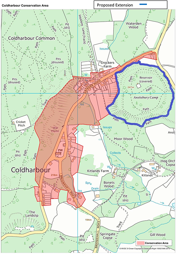
1.3 The central part of Coldharbour is covered by a Conservation Area designated in 1975. The Conservation Area provides an extra layer of protection when coming to review planning applications.
2 Social
2.1 In terms of its social structure and demography, the village has a relatively eclectic mix of residents, professions and age groups and in recent years, a larger number of younger people and young families have moved here.
2.2 The village is a vibrant and thriving community, supporting its parish church, Christ Church, and participating in a very wide variety of social activities including :‐
All of these activities are co‐ordinated by the Coldharbour Sports and Social Club (aka Village Society) which also holds the liability insurance covering all sanctioned village events. In 2007 a project to rebuild the sports pavilion on the cricket ground was successfully completed and a further 99 years lease was negotiated with the National Trust for the use of the ground. A village web‐site (www.coldharbour.net), email group and Facebook page are all extensively used to publicise events, news and opportunities.
There is a children’s playground on the Memorial Ground opposite the church on Abinger Road which is maintained and insured by Capel Parish Council.
The Leith Hill Action Group (LHAG) was established to oppose the planning application to explore for hydrocarbons under the village and within the AONB.
2.3 Capel Parish Council is the elected body which serves the ward of Coldharbour. It owns and maintains the land opposite Roffeys in the village centre and also contributes to the upkeep of the church hedge, the children’s playground, the sports pavilion, the parish notice board and the village clock. Its other primary purpose is to participate in the review process of all planning applications. It also has a web‐site (www.capel-pc.gov.uk) on which details of meetings and councillors can be found. The agenda of all public meetings are also posted regularly on the parish notice board. The council has representatives who sit on other committees such as GACC, LHAG, MVDC Standards Committee, Surrey Hills Board working groups, the Police Rural forum and the Dorking Hills Highway forum. The council is funded by a very small proportion of the annual council tax charge amounting to an average of £40 per annum per household.
2.4 The John Venus Hall and the Church require substantial funds for maintenance which is most challenging for a small village to meet. Many village events are held in both buildings and fund‐raising is achieved by charging for their use. Donations for upkeep are always given as a result of each event.
2.5 Originally a 17th century coaching inn, the Plough Inn is in the heart of the village offering a popular meeting place for villagers and visitors alike. It is the only public house in the village, is the most significant employer in Coldharbour and stages its own activities and events. Recently renovated and with a small general store in the pipeline, this will add extra value to the facilities and easement of local people, whilst the extended pub car park will help to reduce the congestion of vehicles parking in the village centre particularly at weekends.
3 Economic
3.1 The village is populated predominantly by residents who are either retired; semi‐retired; self‐employed working from home; working outside the village in various trades or working outside the village in professional and managerial positions.
3.2 There are only limited sources of employment within the village itself with most work undertaken by people from outside the village.
3.3 Some 6 years ago the Coldharbour Ward, was one of the winners of the national ‘Race to Infinity’ competition organised by BT Openreach. The campaign was spearheaded by Coldharbour residents. This meant that high‐speed, fibre‐optic broadband should have been supplied to all but the most outlying properties in the ward. This roll‐out has still not been completed and the continuing lack of reliable broadband severely affects all businesses and residents.
4 Environmental
4.1 The natural environment of Leith Hill with its forests, woodlands and heathlands provide a wonderful panoramic setting, with opportunities for local residents and visitors to walk, jog, bike ride and horse ride well away from roads and the built environment. The land owned by the National Trust is subject to its inalienable rights, while that leased by the Forestry Commission is also thought to be well protected. Wotton Estate own much of the rest of Leith Hill, to the west of the National Trust and Forestry Commission holdings; their Leith Hill lands, largely woodland, are managed for the public benefit by the Surrey Wildlife Trust, under a long term agreement.
4.2 Much of the other land around the village is either woodland or fields which are predominantly used to keep horses, sheep and other livestock. In some fields corn is grown to provide cover for pheasant. A number of properties in the village keep chickens but Broome Hall Farm is the only active agricultural enterprise.
4.3 The local environment, including the deeply recessed Coldharbour Lane, risks serious damage as a direct result of the decision to permit oil and gas exploration in Bury Hill Wood. This is of great concern to residents who do not want to see any further explorations for or any extraction of hydrocarbons in the Surrey Hills AONB and Metropolitan Green Belt of London.
4.4 Some aspects of the local environment are also being placed at risk as a direct consequence of increases in the number of visitors, with car parking a particular problem. This is further compounded by the increasing popularity of Leith Hill and Coldharbour by mountain bikers and road cyclists particularly at weekends.
4.5 Surrey County Council and the Forestry Commission are failing to keep their byways open to all traffic which includes walkers, horse riders and pedal cyclists. The byways are used, particularly in the winter months, by recreational 4x4 and scramble bike riders. This activity serves to destroy the surface of the byways making them impassable but for the largest of vehicles. On several occasions criminal damage has occurred to the fences, gates and wooden stumps bordering the byways.
4.6 Some mountain bikers and scramble bike riders are threatening the safety of walkers and horse riders when they ride their bikes on bridleways and illegally on footpaths and ‘offpiste’. There needs to be a clearer system of signage of mountain bike trails, public footpaths and bridleways to reduce the risk of injury.
4.7 Specialist Rural policing is extremely important in an environment such as Coldharbour. Often the 101 service offered by the police fails to acknowledge a rural crime and hence issues are not dealt with correctly i.e. the officers eventually arrive in the wrong type of vehicle. A CountryWatch scheme has been established recently which, if updated correctly by the 101 team, is able to send texts and emails to local landowners warning of in‐flight crimes such as fly tipping and burglary and has had some success in catching miscreants.
4.8 The NDP reinforces the conservation of the natural environment of Coldharbour and the whole of the Leith Hill area as this is equally essential to the village and the wider community who visit Leith Hill.
4.9 The NDP should prevent further oil or gas exploration and also prevent any oil or gas extraction from being permitted within the Surrey Hills AONB or Metropolitan Green Belt of London.
4.10 The NDP requires Surrey County Council and the Forestry Commission to maintain their byways and keep them open to ALL traffic and users or alternatively should assist in applying for seasonal closure of the byways to large 4x4 vehicles.
4.11 The NDP requires Surrey County Council and the Forestry Commission designing and erecting clear signs explaining the use of the different pathways.
5 Housing
5.1 It is generally felt that the unique character of Coldharbour, a small rural village perched near the summit of Leith Hill, within the Metropolitan Green Belt and Surrey Hills AONB would gain no benefit from any additional housing stock. It is of course appreciated that whilst a family may need to extend their properties, this should always be done within reason and in full consideration of the village design as a whole. This would also help to maintain the current range of mixed housing stock that is available here. At present whilst the average price of freehold property in Coldharbour is £875,000, prices for a 2 bedroom terraced cottage start at £295,000 freehold.
5.2 The feasibility of ‘affordable’ or ‘shared ownership’ housing has been discussed from time to time and there is some local interest in this. However there is an overwhelming concern that the principle of ‘affordable’ housing can so easily be eclipsed by the spectre of profit over principle. ‘Affordable’ homes and ‘starter’ homes, are not fully protected from inappropriate development and inappropriate speculation on the open market. Additionally, affordable homes are so easily subject to the ‘buy‐ to‐let’ market at exorbitant rental values. Then there is the current imperative of the ‘right to buy’ scheme for social housing whereby council and some housing association properties become private dwellings, developed to the maximum in order to achieve the highest value on the open market.
5.3 In Coldharbour the general consensus is against the provision of new developments, including ‘affordable’ homes, ‘starter’ homes or social housing unless the Housing Needs Analysis conducted in March 2016 by Surrey Community Action confirms otherwise. If the development of ‘affordable’ homes were to proceed then legal covenants must be established to preserve their status in perpetuity.
6 Education
6.1 The village used to have two schools, due to lack of numbers both closed long ago and were converted to private houses.
6.2 There has been an increase in younger children living in the village over recent years there are still insufficient numbers to warrant a school in Coldharbour. Fortunately there are excellent nursery primary and secondary state schools in Abinger Common, Dorking and Westcott and also several pupils are currently being educated in the independent sector.
6.3 No NDP measures are required for Education.
7 Employment
7.1 The only sources of employment within the village are:
7.2 If oil or gas is found from the planned exploratory work, the specialist nature of the work involved is such that it is highly improbable that it would provide employment for any of the present residents.
7.3 No NDP measures are required concerning Employment
8 Transport
8.1 Access to the village is via four narrow lanes, all marked by Surrey Highways as being unsuitable for HGVs. The main highway, Coldharbour Lane provides access to and from Dorking and it is a winding sunken lane, with historic banks on either side for much of its length as it climbs up into the village. Anstie Lane, which is particularly narrow and twisting, is not really suitable for anything other than providing access to the properties along it. Broome Hall Road, although a little wider than Anstie Lane, is also narrow and has some really sharp bends. Abinger Road is also relatively narrow and has suffered from major landslips in recent years.
8.2 It is essential to residents that Coldharbour Lane is kept passable at all times, as it provides the main route out of and into the village. It must also remain on the County Council’s priority 1 list for salting in the winter and should be kept free of fallen leaves throughout the autumn.
8.3 All four access roads are used extensively by road cyclists in increasing numbers since the use of Coldharbour Lane and Abinger Road by the Tour of Britain and their annual use by the Mayor of London’s Classic race (as part of his Ride London event). A particular problem is caused by ‘sportives’, which unfortunately require no permissions even though large numbers of cyclists race against the clock on steep, narrow, winding lanes. Compounding the road behaviour which such events can lead to, is the failure of some cyclists to wear high visibility clothing and to ride with lights creating a danger to all road users. Many of these cyclists also tend to ride in large groups rather than in single file, adding to the risk of traffic accidents.
8.4 The village is served by a County Council supported (subsidised) bus running to Dorking twice a day. While suited for some travel, its times of operation are such that its use by Coldharbour residents is limited. Despite the limitations, it still provides a vital service for those unable or choosing not to travel by motor vehicle.
8.5 As noted in Section 4, Environmental, the use of Leith Hill by mountain bikers and walkers has led to a substantial increase in demand for car parking. While National Trust and Surrey Wildlife Trust car parks accommodate much of this demand, discussions have been held with the Forestry Commission about the provision of additional parking on land off Coldharbour Lane, before the village. However, the site that had been considered is now affected by the planned oil exploration works.
8.6 There is an extensive network of footpaths in and around Coldharbour, some of which are not registered and shown on the County Council’s map of statutory paths – the ‘Definitive Map’. However, most of the unregistered paths are defined under Common Law (reinforced by the1980 Highways Act) as ‘presumed dedications’, having been used for more than 20 years without challenge by the landowner. Since the landowners do not always recognise their responsibilities for such footpaths, it is highly desirable that action is taken to obtain registration. This has become particularly important as under the 2000 Countryside and Rights of Way Act, footpaths not registered by 2026 might cease to be defined as such.
8.7 The majority of residents living in the ‘centre’ of Coldharbour want to see traffic calming and speed reductions as a matter of urgency. At present there is a speed limit of 60 mph along Abinger Road and Coldharbour Lane through the centre of the village where there are no pedestrian walkways at all. There is a serious risk of injury as motor vehicles and cycles speed through the ‘centre’, unaware of residents trying to get in and out of their drives and gates. Abinger Road (just in front of the Plough) is of particular concern owing to the serious ‘life changing’ accident that took place there in March 2015. Additionally, there have been numerous ‘near misses’ when people (some with children) leaving the Plough have inadvertently stepped onto Abinger Road without realising the danger from speeding traffic. Different ideas for traffic calming are currently being considered but there is clearly an imperative to put something in place that can make a difference for the better.
8.8 It is essential for Coldharbour Lane to be kept passable for motor vehicles at all times. It must remain on the County Council’s priority 1 list for salting in the winter and should be kept free of fallen leaves throughout the autumn and that Abinger Road is not adversely affected by further landslides.
8.9 The use of the lanes into and through the village by cyclists, particularly by Sportives, must be monitored and appropriate action taken to ensure the safety and convenience of all users.
8.10 The NDP should specify that steps should be taken to ensure that all footpaths in and around Coldharbour that are in regular use and classed as ‘deemed dedications’ are registered and included on the definitive map.
8.11 The NDP should reinforce with SCC Highways the urgent need for traffic calming measures and speed restrictions through the centre of Coldharbour village.
9. Heritage
9.1 Many houses in Coldharbour are over 100 years old and a number of these are listed here along with Anstiebury Camp (2nd century BC) :‐
9.2 While the built environment is a key element of the special nature of Coldharbour, the natural environment, with its extensive common land and features such as the Dukes Warren (now owned by the National Trust – with some minor exceptions for Coldharbour Common) is the dominant attribute. Much of the National Trust property is designated as a Site of Special Scientific Interest (SSSI), which provides some protection, as does the AONB designation. However, the decision to permit oil and gas exploration within the AONB and the village is most concerning. The risks these works impose on the fragile historic environment of Coldharbour Lane, demonstrates the need for active vigilance to ensure the effective conservation and protection of the natural environment and the multiplicity of endangered species we find here. The present generation has inherited this ecology and wishes to pass it on for the benefit and pleasure of future generations of residents and visitors.
9.3 The NDP must help to reinforce that the natural and historic environment of Coldharbour and its surrounding areas must be afforded the highest levels of protection against any form of development, works or other activities that might cause damage or detriment to this unique environment.
Character and Identity – Coldharbour
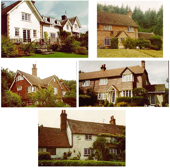
The character identify of Coldharbour is varied and eclectic. The dwelling photographs provide a broad palette of materials, styles and features.
1 Rather than Horsham or Dorking, Holmwood was for many years the outer terminus for suburban trains, running at frequent intervals to and from London,.
< Previous | ^ Top | Next >