
The allocated sites and their development policies
5. ALLOCATED SITES
Introduction
5.1 This chapter of the Neighbourhood Plan details sites allocated for development and policies specific for their development. The policies have to be considered in the context of the NDP having particular regard to its vision for the future of the parish and the sustainability of its villages.
5.2 Capel Parish has five planning designations. The Green Belt, the Surrey Hills AONB, Conservation Areas, Countryside beyond the Green Belt and the village settlements of Beare Green and Capel. Both villages are designated in the Mole Valley Local Plan (Core Strategy CS1) as being inset from the Green Belt.
5.3 The proposed site allocations have had regard to the objectives of the Mole Valley Local Plan for new housing, in particular:‐
5.4 The Strategic Housing Market Assessment (SHMA) June 2016 advocates 7813 new homes for Mole Valley by 2035. This responds to the Government requirement imposed on local authorities to identify the objectivity assessed need for new homes in their area which is the proposed end date for the Capel NDP. This will require 391 new homes per annum. The present delivery is about 165 houses each year.
5.5 Planning Practice Guidance (PPG) states that housing need assessments should be informed by the latest data. The proposals for housing in the villages have had regard to affordability, availability and market demand.
5.6 Section 3 of the Neighbourhood Plan identifies ‘Constraints and Opportunities,’ identifying ‘key objectives’ of the potential development area.
5.7 The sites identified are:‐
The Green Belt
5.8 In consideration of the National Planning Practice Guidance (NPPG) Neighbourhood Plans can come forward before the date of the Local Plan, up to date housing needs evidence is, therefore, relevant to the question of whether Housing Supply Policy in the Neighbourhood Plan for Order contributes to the achievement of sustainable development.
5.9 This is of particular relevance in the Capel Parish NDP given the extent of the Green Belt as currently defined in Mole Valley Core Strategy 2009. There is a need to ensure the Neighbourhood Plan satisfies basic conditions as set out in the Localisation Act 2011 having regard to Paragraph 8 (2) of Schedule 4B of the Town & Country Planning Act 1990 and the advice contained in Guidance issued by the Secretary of State.
5.10 The site allocations proposed take account of the extensive Green Belt within the Plan Area. It is not the role of the Neighbourhood Plan to amend Green Belt boundaries. The broader issue of the identification of housing land both in the District and in the Capel Plan area will be addressed in the emerging Mole Valley Local Plan.
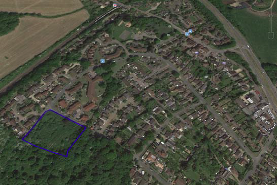
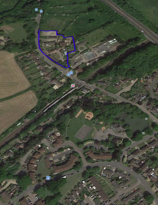
CA‐BG01
Location of BG01 next to Great Turners
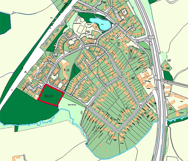
CA‐BG01 – Location of site BG01 next to Great Turners
Policy CA‐BG01 Land off Highland Road as shown on the plan is allocated for outdoor sport and recreation use. The provision of the following ancillary facilities will be supported on the site:
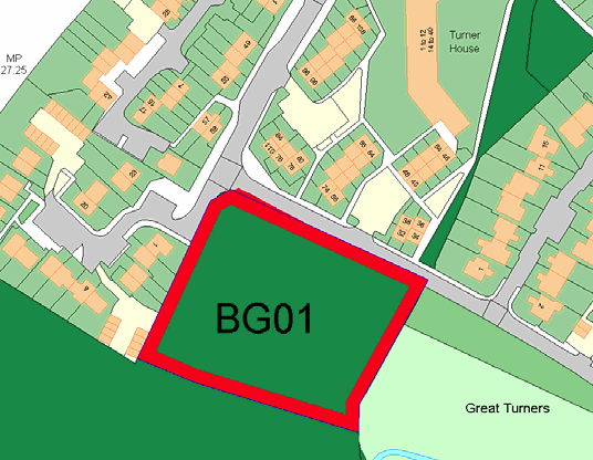
A rectangular parcel of land bordered to the north by Highland Road and Oak End to the west. To the south and east is Great Turners Wood, a Site of Nature Conservation Importance. The site itself consists of grass and undergrowth/ immature trees that have grown up over time. It is generally flat but rises on its boundary with Highland Road.
Key considerations:
The site is in the Green Belt.
Site Area (Ha): 0.48
Description: A rectangular parcel of land bordered to the north by Highland Road and Oak End to the west. To the south and east is Great Turners Wood SNCI. The site itself consists of grass and shrubs/ immature trees that have grown up over time. It is generally flat but rises on its boundary with Highland Road.
Proposed Development: Recreational Open Space.
Suitability
Analysis: The site is in the Green Belt and plays a role in protecting the setting and character of the village and a significant role in terms of safeguarding the countryside from encroachment.
The site relates well to existing housing.
Access: Access to the site would be from Highland Road. The bank fronting Highland Road would need to be regraded to provide an access point.
The existing network of footpaths in the area provide good pedestrian access to the local shops and bus stop.
The site currently contains a number of informal footpaths and connects to Turners Wood adjacent to the site.
Flood Risk: The site is located in Flood Zone 1. The site is close to a water course to the south that passes through Great Turners Wood.
Landscape Character: The site is not within the AONB or AGLV however the AONB boundary is about 150m to the west, along the route of the railway line.
This site is situated to the south of Beare Green, is located within the Wooded Weald LCA, covering the majority of the countryside in the south west quarter of the district.
New screening along the northern and western boundaries of the site will provide landscaped containment.
The southern and eastern boundary of the site is shielded by large mature trees from the adjacent Great Turners Wood.
The Built Environment and Heritage: The site is not in a Conservation Area, there are no Listed Buildings and it is not in an area of archaeological interest.
Taking into account the higher density housing estates to the north and west, and the tight knit building dominated environment with limited areas of open space, the value of this open land to the existing nearby residents for sport and recreation will be of significant benefit to the Beare Green community.
CA‐BG02: Land at Old Horsham Road
Proposed Site Policy
CA‐BG02 – Land at Old Horsham Road, Beare Green is allocated for residential (comprehensive) redevelopment or the development of individual dwellings, subject to the following:‐
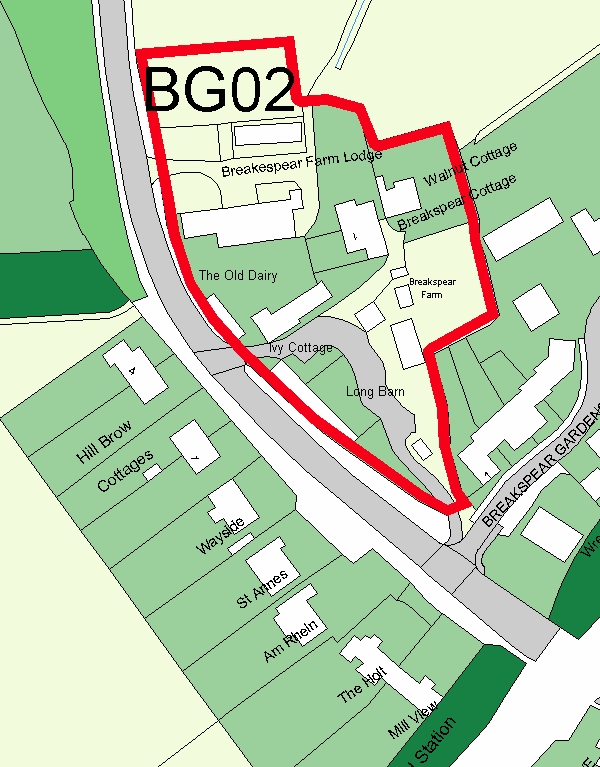
This broadly rectangular area of land comprises a number of individual buildings in residential use.
The site lies in the Green Belt east of Old Horsham Road and close to the AONB. The western edge of the site provides a 'soft' edge.
It lies in close proximity to transport services, shops and community facilities.
Key Considerations
Sustainability
The site is sustainable and appropriate for residential development relating well to the existing and emerging community.
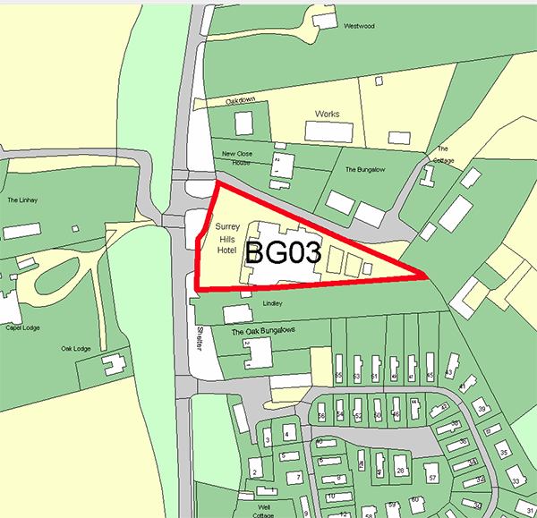
CA‐BG03 Surrey Hills Hotel
CA‐BG03 ‐ Surrey Hills Hotel, Horsham Road, Beare Green, Dorking
POLICY CA‐BG03
LAND AT SURREY HILLS HOTEL, HORSHAM ROAD, BEARE GREEN
BG03 Land at Surrey Hills Hotel, Horsham Road, Beare Green is allocated for residential development at a minimum of 10 dwellings, subject to the following:‐
Site description:
The site lies to the east of Horsham Road. It is 0.35 ha. The site is triangular in shape, with a wide frontage to Horsham Road, narrowing to a point at its eastern end.
The site is currently occupied by the Surrey Hills Hotel, a large two storey building positioned centrally within the site. To the west of the building is a large gravel car park, and to the east of the building are gardens for the hotel and an associated single storey pump house structure. There are two bell‐mouth access driveways from Horsham Road to the north and south of the parking area, utilised as both pedestrian and vehicular accesses.
The site is generally flat, with gentle slopes across the site width. A drainage ditch presents a low‐point for the site along the northern boundary.
High hedgerows are present on the northern and southern boundaries, which are generally continuous with some limited breaks. There are a number of larger trees to the eastern point which are mainly focussed where the site is at its narrowest.
Despite only having seven rooms the hotel (rated 3 star) regularly holds functions and live music that end late in the evening and has an entertainment license for up to 500 people. Entertainment functions are regularly held at weekends and the hotel is also a wedding and conference venue. The hotel is run on a part‐time basis and staff are brought in as necessary for functions.
Part of the ground floor of the building is a restaurant that operates independently of the hotel. This is open every day from 12noon till 2pm and 5.30pm to 11pm and can cater for parties of up to 60 people.
There is also a 3 bedroom self‐contained flat occupying part of the first floor.
Proposed development:
The site is an allocation for residential use in the Neighbourhood Plan.
The Parish Council’s local planning policy for the development of around 10‐12 units will require the provision of affordable homes on site. It will be difficult to ensure an acceptable layout that adheres to the agreed building line, provides sufficient parking and has no adverse impact on residential amenity.
The development comprising largely small units will ensure the scheme complies with Green Belt objectives.
A viable scheme that also complies with Green Belt policies, the established building line, parking and amenity requirements, is the development of a small number of family‐sized dwellings with affordable homes or starter homes.
The proposed dwellings will continue the established building line along Horsham Road, being set back from the road by at least 16.5m, provide sufficient parking and meet residential amenity standards.
The overall aim of the proposal is to improve the housing provision and mix available in Beare Green, with an emphasis on providing for a mix of family dwellings.
Access/ highways:
The site is currently accessed via two existing bell‐mouths onto Horsham Road. These access points should be closed and landscaped, and a single new central access point is the most logical proposal to improve highway safety on Horsham Road (as proposed in Martin Grant Homes planning application).
The proposed driveway access through the site is a shared pedestrian and vehicle surface. The transition between Horsham Road and the driveway is denoted by granite setts, with the driveway being either bound or bonded gravel throughout.
Physical constraints:
Community/services:
Nature conservation/built environment:
Confirmed ecological constraints to development at the site are:
CA‐BG03 – Surrey Hills Hotel
< Previous | ^ Top | Next >