
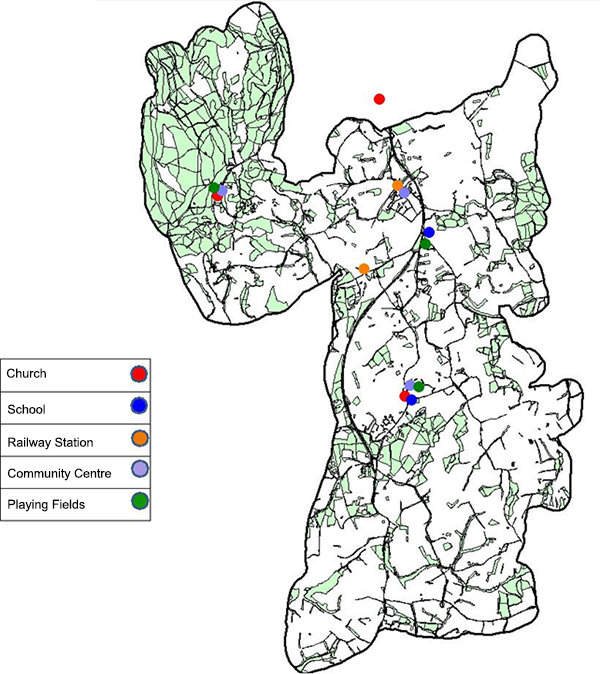
Figure 1 ‐ Plan showing key places in the Parish of Capel
ABOUT CAPEL PARISH
2.1 Understanding the Parish is the starting point for producing a good Neighbourhood Plan. This is because the Capel Neighbourhood Plan is an opportunity to plan the Parish’s future. What are the problems that the Plan could address? What are the opportunities the Plan could make the most of?
The Parish Today
2.2 A wide range of issues have been considered in producing the Plan. These can be grouped under five themes:
2.3 An overview of these five themes is set out below. This overview includes information from background reports along with issues raised by local people at the various consultation events. A more in‐depth summary of the background reports is available in the Evidence Base Summary that accompanies this Plan. A full report of issues raised during consultation is set out in the separate consultation reports, with an overview provided in the ‘Consultation Statement.’
Housing
2.4 The Parish of Capel has a population of around 3,500 people.
A review of available housing data shows that there is:
2.5 Consultation with local people has revealed concerns about the affordability of housing in Capel, particularly for young people and families. People are also concerned about there being a range of housing types available – the perception is that many new developments are skewed towards larger dwellings.
Working and Shopping
2.6 The Parish is generally an affluent area. However, there are areas of the population who live in areas identified as ‘concentrated’ social housing in Beare Green and Capel.
2.7 There are high levels of commuting out from the villages through a combination of transport methods. To the north and south public transport (rail and bus services) facilitates access to Dorking and Horsham. Rail transport via these two towns provides indirect links to Gatwick and Crawley, two significant employment centres.
2.8 What facilities are provided within the Parish of Capel?
2.8.1 Shopping
The facilities in Beare Green and Capel meet the local needs of the communities, albeit in a limited and basic way. In Coldharbour, a local shop, linked to the village pub, opened in early 2017, which will benefit the village.
2.8.2 Offices/Businesses
A number of local businesses with a particular emphasis of work/home activities exist in the Parish. Local rural community “sustainable best practice” will ensure that any new development contributes to the economic vitality of the area.
2.8.3 Agriculture
The three villages are set within an agricultural environment, including land occupied by the Forestry Commission.
2.8.4 Getting Around
Walking is an important mode of transport ‐ being just as essential as the motor car and public transport. Bus stops are usually accessed on foot. About 80% of rail travellers arrive at or leave Holmwood railway station (at Beare Green) on foot, with a lower percentage at Ockley (used by Capel residents) due to its more remote location.
2.9 The National Planning Policy Framework (NPPF) March 2012, Paragraph 30 promotes sustainable transport. This NDP also embraces the objectives set out in paragraph 39 (page 11) of the NPPF concerning the availability and opportunities for public transport, local car ownership and the need to reduce high vehicle emissions.
2.10 The village cores of Capel and Beare Green generally provide easy and safe walking on pavements, as they are fairly flat and compact. Coldharbour is much more undulating and has no pavements. All parts of the Parish connect well with the adjacent countryside through a network of rural roads, footpaths and bridleways
2.11 These same characteristics also make Capel Parish suitable for cycling ‐ with the exception of the A24 dual carriageway. There are few cycle routes, with most cyclists using streets to get around. Incorporating traffic calming measures into the Capel village environment, and suitable improvements for traversing the A24 at appropriate points are both desirable and strategic aims.
2.12 The evidence shows a perception that bus services and access to them appears to be relatively poor. This must be balanced against the fact that this is a rural area and the current service through Beare Green and Capel Village runs approximately hourly during the day, seven days per week. The railway stations serving the Parish are Holmwood at Beare Green and Ockley near Capel. Poor cycle and bus access to the stations are identified as problems by local people, as are car parking facilities for commuters.
Leisure and Wellbeing
2.13 An assessment of community facilities within the Parish is available as part of the Evidence Base. The survey of facilities included an overall satisfaction in the provision of sports, play and shopping facilities (see 2.15).
2.14 Capel village has a very active community life, represented by many different groups and organisations. The perception identified at public consultations is that most of the existing community facilities are of small to medium capacity.
2.15 The Housing and Community Survey and consultations identified the need to consider and review:
The satisfaction responses for these aspects are as follows:
• |
Beare Green |
63% Satisfied |
• |
Capel |
67% |
• |
Coldharbour |
65% |
• |
Beare Green |
76% Satisfied |
• |
Capel |
68% |
• |
Coldharbour |
85% |
• |
Beare Green |
68% Satisfied |
• |
Capel |
81% |
• |
Coldharbour |
30% |
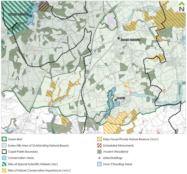
Figure 2 ‐ Map of Parish showing character of the natural environment.
Environment, Sustainability and Design Quality
Environment
2.16 The Parish generally has a high‐quality environment. Capel and Coldharbour have at their heart Conservation Areas, whilst attractive landscape, including good open spaces and parts of the Surrey Hills Area of Outstanding Natural Beauty (AONB), surrounds all the villages.
Flooding
2.17 Flooding is a regular issue in and around Capel and Beare Green. Sustainable drainage systems (SUDS) should be applied to new development in order to achieve a positive impact on local water resources and supply; the implementation of water use efficiency measures; re‐use and recycling; minimisation of water extraction and pollution, together with the fostering of sustainable water and sewage management in the landscape. This is a key sustainable objective of the NPPF.
Open Space
2.18 Capel and Coldharbour benefit from having recreation land and playing fields within the villages. Beare Green also has an area for sport and recreation but is separated from the village environment being located east of the A.24. These areas are identified in the respective village settlement plans.
The proposal for designating site BG01 (Land off Highlands Road, Beare Green) as recreation land and playing field being closely related to the village community is therefore seen as a priority.
Historic Landscape
2.19 Leith Hill is an historically important landscape. It is also designated as an AONB. To the south of Capel, a number of Sites of Special Scientific Interest (SSSI) exist. The landscape character has regard to a complex topography of ridges and valleys, woodland, including Ancient Woodland (woodland that has existed continuously since 1600 or before) and rural lanes all contributing to the landscape and, particularly in Coldharbour, a sense of tranquillity. (See Figure 2.)
Character and Heritage
2.20 The villages comprise a number of broad character areas that make up the built environment of the Parish. These are based on an analysis of the Parish. Its heritage is emphasised by Conservation Areas, Listed Buildings, and the distinctiveness of the three villages, lanes, landscape, arable and pastoral fields, hedges, trees and woodlands.
Capel and Coldharbour Conservation Areas
2.21 These “character areas” make a significant contribution to the Parish as a whole. The areas were reviewed as part of the Landscape and Sensitivity Assessment (the CSA Report – April 2016). The only recommendation by CSA is to extend the Coldharbour Conservation Area to include Anstiebury Fort.
Surrey County Council Heritage Conservation support the inclusion of the Fort within the Coldharbour Conservation Area which will improve its protection as a scheduled Monument. It is also recommended by Surrey County Council to examine the wider context of the site to establish “view corridors both to and from the Monument, to protect and enhance its rural character in the future.” (September 2016).
An application will be made to Mole Valley District Council to extend the Coldharbour Conservation Area.
Landscape (General)
2.22 Land to the west of the A24 and north/west of the A29 rises towards the Surrey Hills AONB and is the highest point in Surrey. However, to the east the landscape is more variable, although Capel village is well contained visually to the south/east by rising land and the designated Private Nature Reserve (reference: Landscape Sensitivity Report by CSA)
Housing
2.23 Main comments raised by local people during the consultation include:
Objective: Integrate new housing with a range of accommodation including bungalows.
Objective: Provide a greater range of affordable housing.
Objective: Provide a range of different housing types across all tenures.
Working and Shopping
2.24 Main comments raised by local people during the consultation include:
Objective: Support village shops
Objective: Provide new employment.
Getting Around
2.25 Main comments raised by local people during the consultation include:
Objective: Connect new housing with good pedestrian, cycle and bus connections
Objective: Improve existing pedestrian and cycle corrections
Objective: Improve connections to surrounding destinations
Objective: Plan public transport to better meet users’ needs
Objective: Ensure car parking within Beare Green supports the viability of the railway.
Objective: Manage tourism issues in Coldharbour.
People and Vehicles/Streets and Surfaces
2.26 The streets in Coldharbour and Capel have an intimate character lacking definition of its “Public Realm”. In Capel, high levels of traffic movement and on‐street parking detract from its intimacy. In Beare Green, the narrow streets are also dominated by on‐road parking although the impact is less given the more “urban” nature of that part of the village.
2.27 Children need the area to be safe and accessible, as do people with restricted mobility. The constraints are shaped by existing development along The Street, existing routes and movement patterns.
2.28 The Neighbourhood Plan seeks to provide solutions to these identified problems but will have regard to:
2.29 The objective will be to reinforce ‘a sense of place’ to add to and enhance the amenity of the village through ‘street remodelling’ with a strong visual boundary.
2.30 The new features to be incorporated will include:
The aim will be to provide speed constraint features with a target maximum of 20 mph. The driver perception will aim to achieve an appropriate speed through strong visual elements rather than signage and artificial clutter. The restricted forward visibility is designed to generate caution. The target speed limit should therefore be self‐enforcing.
Objective and Policy
2.31 To maximise enjoyment of the intrinsic qualities of the “public realm” throughout the Parish and achieve an improved environment for pedestrians and horse riders whenever they encounter motor vehicles.
< Previous | ^ Top | Next >