
11.1 Baltonsborough
11.2 Beckington
11.3 Binegar & Gurney Slade
11.4 Butleigh
11.5 Chewton Mendip
11.6 Chilcompton
11.7 Coleford
11.8 Coxley
11.9 Croscombe
11.10 Ditcheat
11.11 Doulting
11.12 Draycott
11.13 Evercreech
11.14 Faulkland
11.15 Holcombe
11.16 Kilmersdon
11.17 The Lydfords
11.18 Meare and Westhay
11.19 Mells
11.20 Norton St Philip
11.21 Nunney
11.22 Oakhill
11.23 Rode
11.24 Stoke St Michael
11.25 Walton
11.26 West Pennard
11.27 Westbury sub-Mendip
11.28 Wookey
11.29 Wookey Hole
11.1.1 Baltonsborough is a small village - closely related to adjoining Ham Street - approximately 4 miles south east of Glastonbury. It is bounded on the south west by the River Brue and is an area mainly given over to dairy farming.
11.1.2 The village is within the Baltonsborough Farms and Orchards Landscape Character Area. Orchards are the most dominant characteristic within this area and these stand out in contrast to the adjacent moors. This area is characterised by frequent dispersed settlements linked by numerous narrow winding lanes and small fields.
Infrastructure
11.1.3 Issues raised through the development of the Local Plan have been around the lack of infrastructure in the village. This includes sewerage, road, no mains gas supply to the village and poor mobile phone coverage. Sensitivities regarding the former have been confirmed by Wessex Water and site visits to the village have confirmed the sensitivity of the road network.
11.1.4 The village school is at capacity and feasibility work would be needed to test whether additional demand could be accommodated. Financial contributions for education may be sought from proposed developments in this area.
Site Allocations
11.1.5 Baltonsborough is identified in LPP1 as a Primary Village with a minimum housing requirement of 45 dwellings reflecting the smaller size of the village. There has been a significant level of development in the village with completions and consents (2006-17) totalling 131 dwellings. This is more than the planned level of development in LPP1. There is no residual level of development to be delivered through LPP2. In accordance with this strategy no further sites have been allocated in Baltonsborough.
Windfall Development
11.1.6 Baltonsborough continues to have an identified development limit. Therefore, over the lifetime of the plan additional small scale development can potentially come forward within this boundary.
Development Limit
11.1.7 Amendments are proposed to the development limits to reflect committed development and around the current DPD site at the eastern edge of the village. The committed sites to be included are found at:
11.2.1 Beckington is a village of some 360 homes with a population of approximately 900 people. Being three miles from Frome, and close by the A36, it is well connected by road. The village is situated on the east side of the valley of the River Frome with the core sited on a fairly level platform above the river’s flood plain, between low rounded hills to the north and south. Bath Road forms the spine of the village. Church Hill climbs steeply from its northern end and the Parish Church is situated at a high point above the main part of the village.
Site Allocations
11.2.2 Beckington is identified in LPP1 as a Primary Village with a minimum housing requirement of 55 dwellings in Policy CP2. Completions and committed development in the plan period to date totals 108 dwellings, a 30% increase to dwelling stock. Given this level of growth, no sites were allocated in Beckington in the Submission plan. Following the examination hearings, additional allocations are necessary to make the plan sound, specifically to address the requirement in Policy CP2 to provide 505 dwellings located adjacent to Midsomer Norton and Radstock and in settlements in the north/northeast of the district.
11.2.3 A site south of Great Dunns Close has been identified as a sustainable location although outside adopted development limits. A development proposal on this site was refused on appeal on this site in 2018 but established that settlement infrastructure constraints could be overcome. It is considered deliverable as a medium term site.
Education
11.2.4 The village school is near capacity and not capable of expansion. However, roll numbers are predicted to fall in the medium term. Financial contributions for education may be required for transport to alternative schools depending on the timing of development.
Highways
11.2.5 The Highways Agency have identified capacity issues on both A36 roundabouts which link to the village. Development proposals are subject to Policy DP27 - Highway Infrastructure Measures for Frome, Beckington and Rode’. Major proposals which require a traffic impact assessment will need to take this into account and may be subject to development contributions to support strategic highway infrastructure.
Drainage and Sewage Infrastructure
11.2.6 A comprehensive drainage review was undertaken in 2020 in the village to address long-standing issues relating to surface water, highway and sewer flooding in high rainfall in the village. This identifies a range of measures to reduce flood risk and provide capacity for surface water and sewage flows.
Windfall Sites
11.2.7 Beckington continues to have an identified development limit. Over the lifetime of the plan, additional small-scale development can potentially come forward within this boundary.
Development Limit
11.2.8 Changes to the development limit have been made to reflect committed development. There are four significant sites which have planning permission which have now been included within the development limits - south of Warminster Road, north of Warminster Road, off Bath Road and at Mill Lane.
Context
The site is 1.2 ha and consists of fields adjacent to a recent development at Great Dunns Close. There is development to the north, west and south and a hotel to the north east. As such it is well contained and does not have extensive views of the countryside. The site is central to the village and close to village amenities. The site is in relative proximity to a junction of the A36.
Highways
Access is proposed via the recently completed development to the north. The development at Great Dunns Close has footpaths which connect to the existing network on Bath Road. The allocation should link with the surrounding footpath network.
Landscape & Ecology
There is a prominent hedgerow with trees which is central to the site. The site lies entirely within Band C for Greater Horseshoe bats from both the Mells Valley SAC and the Bath and Bradford on Avon Bats SAC. Therefore, some mitigation will be necessary.
Heritage
Development should respect the local context and be sensitive to the location. The Beckington Conservation Area lies to the south of the site and eight listed buildings are in close proximity. A buffer of green space should be provided to protect the setting of the heritage assets, having regard to the landform which rises northwards from the Conservation Area boundary.
Flood Risk and Drainage
Surface water drainage and sewer capacity in the village is under review and work is ongoing to establish capacity. Development proposals will need to demonstrate drainage capacity can be accommodated without a detrimental impact on the wider settlement and will need to work with relevant agencies and utilities providers. A limited area of medium surface water flood risk lies adjacent to the site.
School Infrastructure
Beckington First School is within the village and has a capacity of 88 pupils. It is currently near capacity and has no ability to expand, although by 2023 numbers are expected to fall and more places will be available. Depending on the timing of development, there may be capacity to accommodate the pupils from the allocation. Development contributions may be required for transport to alternative schools.
Policy BK1: Development Requirements and Design Principles
Policy BK1: Land south of Great Dunns Close
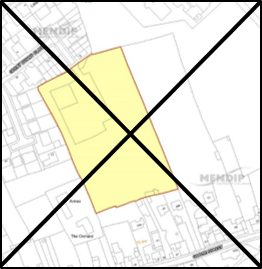
© Crown copyright and database rights 2021 Ordnance Survey 100019309.
Additional Information © Mendip District Council.
11.3.1 Gurney Slade lies on the A37, 6kms from Shepton Mallet and 5kms from Chilcompton. The village of Binegar lies immediately to the west. The development of both villages has been characterised by farming and quarrying and an active mineral quarry still operates at Gurney Slade.
11.3.2 Binegar is a sensitive location which is rural in nature. It is sparsely developed over a series of narrow country lanes. Development of any scale here would significantly alter the open rural nature of the village. The setting of the church is also an important characteristic of the village which should be protected. Sites in Binegar have the potential to impact on the Mells Valley SAC. Binegar does not have public surface water mains drainage.
11.3.3 Gurney Slade is less sensitive in landscape terms, but sites here are constrained by the proximity to Gurney Slade quarry and access issues onto the busy A37.
Infrastructure
11.3.4 The nearest village schools at Oakhill and Chilcompton are over capacity. Financial contributions for education may be sought from proposed developments in the area.
Site Allocations
11.3.5 LPP1 designates Binegar and Gurney Slade together as a Secondary Village, expected to deliver a minimum of 40 new homes. Recent years have seen relatively low levels of windfall development with completion and consent levels from 2006-2017 totalling 11 homes.
11.3.6 While there is a residual level of homes to be delivered, the suitability of these settlements for additional development is constrained. Both villages fall within a groundwater protection zone where drainage/sewage provision is susceptible to infiltration and there is a risk of rising groundwater. Wessex Water have advised that further investigations would be needed to assess the local impacts from sewer flooding and the options to mitigate the impact. A Local Groundwater management strategy agreed with the Local Flood Authority is recommended. The lack of drainage infrastructure means that small-scale windfall development could also impact flood risk.
11.3.7 None of the available sites are suitable locations for development - they could not be developed without a significant impact on local landscape and infrastructure. Given the constraints, an allocation would be preferable to additional windfall development. A small scale development (a minimum of 11 dwellings) could be accommodated at the junction of Station Road/A37 (GS001). However, the site lies adjacent to a designated wildlife site and there are a number of other considerations including sewerage and access.
Site Allocations
11.3.8 The following site is allocated for residential development under Policy GS001:
Development Limit
11.3.9 The development limit has been amended to include a new small site at the rear of Rock House, to accommodate an anticipated two homes.
Context
The site is a gently sloping paddock lying behind an area of linear residential development which fronts the A37. It is 0.4ha in size and adjoins the development limit. The western edge of the site is defined by woodland which slopes upwards away from the site.
Landscape & Ecology
Further investigation of the site’s ecological impacts will be needed, specifically the impact on the Mells Valley SAC (the site is a very suitable habitat for the greater horseshoe, lesser horseshoe, Daubenton’s and barbastelle bats) and impact on the adjacent stepping stone (Broad Leave Wood) of the ecological network and Binegar Quarry Local Wildlife Site.
Highways
The site has a means of access onto Binegar Lane and will need to meet highways standards on width and visibility.
Infrastructure
The nearest village schools at Oakhill and Chilcompton are over capacity. Financial contributions for education may be sought from proposed developments in the area.
Heritage
While the site does not lie within a Conservation Area or in the vicinity of any designated heritage assets, any development should respect the local context and be sensitive to the rural character of the village.
Highways
Appropriate consideration of access will be required due to the site’s proximity to the A37.
Policy BG1: Development Requirements and Design Principles
Policy BG1: Land off Station Road, Gurney Slade (HELAA Site GS001)
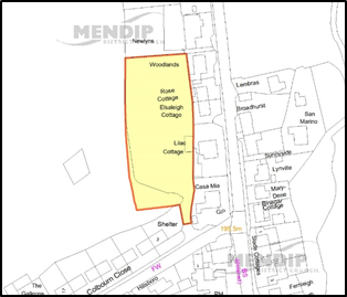
© Crown copyright and database rights 2021 Ordnance Survey 100019309.
Additional Information © Mendip District Council.
11.4.1 Butleigh is a medium sized village, located in the south west of the district. It lies approximately 3km from Street and 5km from Glastonbury. The village lies on the Somerset Moors and is within the Polden Ridge landscape character area. This area is characterised by large open fields and by the traditional orchards, woodlands and parkland which surround the village.
Site Allocations
11.4.2 LPP1 set a minimum housing requirement of 45 dwellings due to the smaller size of the village. The development limits are extended to include development at Butleigh Hospital, to reflect recent development of 15 homes. Completions and consents from 2006-2017 total 28 houses. Consequently, there is a residual level of 17 homes to be delivered through LPP2. Due to the number of homes still to be developed it is appropriate to look for a site(s) to allocate to deliver this housing. Land at West View, Sub Road is allocated for residential development under BT1.
Windfall Development
11.4.3 Butleigh continues to have an identified development limit. Therefore, over the lifetime of the plan additional small scale development can potentially come forward within this boundary.
Development Limit
11.4.4 The development limit has been altered to:
Context
The site is 1.6ha and comprises an undeveloped area to the south of the main core of the village, lying outside but adjacent to, development limits.
Landscape & Ecology
The site is near a Local Wildlife Site and also a woodland ‘stepping stone’ in the ecological network, forming arable and improved/unimproved grassland. Lesser horseshoe, serotine and brown long-eared bats are likely to be present at low density. The potential level of impact from development is considered to be negligible.
The settlement is within an area where wastewater and other water flows may have a ‘likely significant effect’ on the Somerset Levels and Moors RAMSAR which is in an ‘unfavourable condition’. Development allocations should assess additional phosphate loading on the catchment of the designated area and a mitigation solution agreed to secure a ‘phosphate neutral’ position.
Highways
There site has access onto Sub Road and will need to meet highways standards on width and visibility. Footway connections into the village will also need to be considered.
Heritage
Site abuts the Conservation Area therefore development will need to be sympathetic to this and sensitively designed to ensure that the conservation area setting is not harmed.
Policy BT1: Development Requirements and Design Principles
Policy BT1: Land at West View, Sub Road (HELAA Site BUT003)
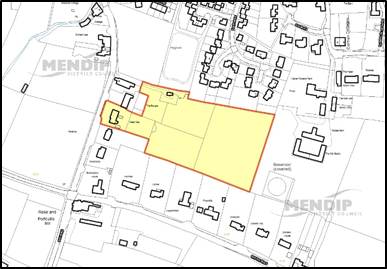
© Crown copyright and database rights 2021 Ordnance Survey 100019309.
Additional Information © Mendip District Council.
11.5.1 Chewton Mendip is a small village in the north of the district, approximately four miles from Wells and 16 miles from Bristol. It lies partly within the Mendip Hills Area of Outstanding Natural Beauty and is the source of the River Chew. The village is well connected in terms of roads with the A39 running through it.
Site Allocations
11.5.2 Chewton Mendip was identified in LPP1 as a Secondary Village and because of the small size of the village and its location on the edge of the AONB future housing numbers in the village were limited to 15 dwellings. Recent years have seen low levels of development. Completion and consent levels from 2006-2017 have resulted in 6 homes being delivered. Therefore, there is a residual requirement of 9 homes to be delivered through LPP2.
11.5.3 Due to its classification as a Secondary Village, Chewton Mendip continues to have an identified development limit. Therefore, over the lifetime of the plan additional small scale development can potentially come forward within this boundary and this is likely to be sufficient to provide the 9 homes required. No sites will be allocated in Chewton Mendip.
Development Limit
11.5.4 An amendment has been made to the development limit to include part of a converted building at Kings Hill.
11.6.1 Chilcompton is the third largest village in Mendip located in the north of the district near Westfield and Midsomer Norton town centre (in Bath and North East Somerset). The village is characterised by linear development along its main roads and an older village area along Parsonage Lane/The Street. There are a number of small-scale employment sites within and on the village periphery.
Site Allocations
11.6.2 Chilcompton was identified in LPP1 as a Primary Village and expected to accommodate 70 homes. There have been very high levels of development in recent years with 156 homes completed or consented between 2006 and 2017. This is significantly more than the planned level of development for the village therefore there is no residual level of development to be delivered through LPP2. In line with this strategy no sites have been allocated in Chilcompton.
Infrastructure
11.6.3 The village school is over capacity and not capable of further expansion. Financial contributions for education may be sought from proposed developments in this area.
Windfall development
11.6.4 Chilcompton continues to have an identified development limit. Therefore, over the lifetime of the plan additional small scale development can potentially come forward within this boundary.
Development Limit
11.6.5 The following amendments have been made to reflect recent development:
11.7.1 Coleford is the second largest village in Mendip, situated to the north of the River Mells and five miles west of Frome. It played a central role in the Somerset coalfield. The village is accessed by a complicated network of minor roads and is isolated from the main routes, being just under three miles from the A367 to the west and around four miles from the A361 to the south.
Infrastructure
11.7.2 The village school is over capacity and a feasibility study would be needed to test whether additional demand could be accommodated. Financial contributions for education would be sought from proposed developments in this area.
11.7.3 There are a number of wildlife sites around the village, and it is partly within the Mendip Bat Consultation Zone. The landscape setting is particularly important to the character of the lower part of the village.
Site Allocations
11.7.4 LPP1 limited future housing numbers in the village to 70 due to the environmental constraints and the isolation of the village from main transport routes. Recent years have seen relatively high levels of windfall development and completions and consents from 2006-2017 have already provided for 67 homes. Consequently, there is a residual level of 3 homes to be delivered through LPP2.
11.7.5 A suitable site has been put forward, which could deliver above the minimum requirement number of homes but remain proportional to the size, needs and limitations of the settlement.
Windfall Sites
11.7.6 Coleford continues to have an identified development limit. Over the lifetime of the plan, additional small-scale development could potentially come forward within this boundary.
Development Limit
11.7.7 One change to the development limits is included, to reflect committed development at the rear of the Gospel hall.
Context
The site is 0.72ha and is outside but adjacent to, development limits. It is a brownfield site which is currently not in use. It is well related to the village and accessible to most village facilities. It is enclosed by building/structures on three sides and the recreation field on the fourth side. It is visually well contained. The site could provide for the residual housing requirement in the village and some additional homes above minimum requirement.
Landscape & Ecology
The site is in the Mendip Bat Consultation Zone. Lesser horseshoe, brown long-eared and common pipistrelle bats are possibly present at moderate densities. Greater horseshoe, soprano and serotine bats are present at low densities. The site may form part of a commuting structure for bats around the north side of the village. Maintenance of ‘Favourable Conservation Status’ is likely to require an area of replacement habitat for bats pending bat activity survey findings.
Heritage
While the site does not lie within a Conservation Area or in the vicinity of any designated heritage assets, any development should respect the local context and be sensitive to the rural character of the village.
Highways
The site has a means of access via a lane to Newbury Cottages and will need to meet highways standards on width and visibility at the junction with Highbury Street.
Land Contamination
The site is a former landfill which will require remediation. This will require on site investigation at an early stage.
Policy CL1: Development Requirements and Design Principles
Policy CL1: Land off Highbury Street (HELAA Site COLE024)
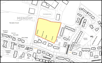
© Crown copyright and database rights 2021 Ordnance Survey 100019309.
Additional Information © Mendip District Council.
11.8.1 Coxley is a small village clustered around the A39, approximately two miles south of Wells, including Coxley Wick and Upper Coxley. It lies close to the River Sheppey and is one of a number of settlements lying in the parish of St Cuthbert (Out).
Site Allocations
11.8.2 Coxley is designated in the LPP1 as a Secondary Village and expected to deliver a minimum of 40 homes. 74 homes have been built to date and a further 7 have been granted permission or are under construction. This gives a total of 81 homes. Coxley is constrained in planning terms by areas of high flood risk, heritage assets and access issues onto the A39 and/or narrow rural lanes. The village has also seen high levels of recent development and in light of this, it is not proposed to allocate any further housing sites in Coxley.
11.8.3 The site COX030 could offer significant benefits to the village in terms of a community hub and is well located in relation to the village core and existing facilities. However, concerns about access, flooding and impact on protected species will need to be appropriately addressed.
11.8.4 Due to its classification as a Secondary Village, Coxley continues to have an identified development limit. Therefore, over the lifetime of the plan additional small scale development can potentially come forward within this boundary.
Development Limit
11.8.5 The development limit has been amended to reflect new development adjacent to the A39, at “Coxley Vineyards” including the existing former hotel.
Context
This 0.25ha site is bounded by the housing at the former Pound Inn to the southwest, A39 to the southeast and mature hedgerows and open fields to the northeast and northwest. This land lies at the crossroads of the three communities of Coxley, Upper Coxley and Coxley Wick and so is geographically at the centre of the community. The site would form an extension of linear development along the A39, further linking the clusters of Coxley and Upper Coxley. The site would adjoin existing development at the former Pound Inn and would sit opposite development around Stoppers Lane and low density development the other side of the river.
Landscape & Ecology
The site is an area of unimproved grassland with scrub, although the southern area of the site is a car park.
The River Sheppey, a wildlife corridor, runs along the site’s northeast borders and is bounded by mature trees. The river supports otters and Daubenton’s bats which are sensitive to the removal of bankside vegetation and introduced lighting.
The site is potentially used by lesser and greater horseshoe, serotine and common pipistrelle bats at low density and brown long-eared bats at moderate density.
The settlement is within an area where wastewater and other water flows may have a ‘likely significant effect’ on the Somerset Levels and Moors RAMSAR which is in an ‘unfavourable condition’. Development allocations should assess additional phosphate loading on the catchment of the designated area and a mitigation solution agreed to secure a ‘phosphate neutral’ position.
Heritage
While the site does not lie within a Conservation Area or in the vicinity of any designated heritage assets, any development should respect the local context and be sensitive to the rural character of the village.
Highways
Provision of safe access will require careful consideration due to the site’s position on the A39.
Policy CX1: Development Requirements and Design Principles
Policy CX1: Land adjacent to the Pound Inn and A39 (HELAA Site COX030)
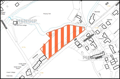
© Crown copyright and database rights 2021 Ordnance Survey 100019309.
Additional Information © Mendip District Council.
11.9.1 Croscombe is a small village of some 250 homes that lies in the valley of the River Sheppey. Its historic centre contains many buildings of great character, including the Church of St Mary the Virgin with its unusual spire.
11.9.2 Croscombe is characterised by its topography, situated in a steep sided valley with important public views from surrounding hillsides. The steep sides of the valley lead to pasture and woodland, much of which is of great environmental significance.
Site Allocations
11.9.3 Croscombe is designated in the LPP1 as a Primary Village. It is expected to deliver at least 35 new homes over the Local Plan period 2006-2029, a level which takes into account its topographical constraints. A further 15 homes are still to be delivered. A small site has been included within an extension to development limits at Coombeside, which could provide up to 5 new homes. The remaining 10 homes might be expected to come from infilling within the development limits.
Windfall Development
11.9.4 Croscombe continues to have an identified development limit. Therefore, over the lifetime of the plan additional small scale development can potentially come forward within this boundary.
Development Limit
11.9.5 The following amendments are proposed to the development limit:
11.10.1 Ditcheat is a small village in Mendip approximately 7km south of Shepton Mallet and 4km north-west of Castle Cary. It is situated in the Brue Valley and has retained much of the character once typically found across the county, with small pockets of traditional orchards. The village is only served by minor roads so is not as well connected as other villages.
Site Allocations
11.10.2 LPP1 designated Ditcheat as a Primary Village. It was expected to deliver 25 new homes, a figure which reflects the small size of the village. To date, there have been very low levels of incremental development, with only 6 homes completed or permitted in years 2006-17. Given the low level of incremental development and residual requirement for 19 homes it is considered that an allocation is appropriate.
11.10.3 The residual requirement can be accommodated in two small pockets of development across the village to reflect the views of the Parish Council and other respondents and respect the rural context and character of the village. The residual requirement is therefore to be met in two sites.
Infrastructure
11.10.4 The village school is over capacity and a feasibility study would be needed to test whether additional demand could be accommodated. Financial contributions for education may be sought from proposed developments in this area.
Windfall Development
11.10.5 Ditcheat continues to have an identified development limit. Therefore, over the lifetime of the plan additional small scale development can potentially come forward within this boundary.
Development Limit
11.10.6 No further changes have been made to the development limit.
Context
The greenfield site is 2.49ha in size and currently in agricultural use. It lies to the very east of the village, with its western edge bordering existing development. A recreation area lies adjacent to the south west of the site.
Landscape & Ecology
Biodiversity records indicate the presence of barn owls and grass snakes in the area but the site is not considered suitable habitat.
The settlement is within an area where wastewater and other water flows may have a ‘likely significant effect’ on the Somerset Levels and Moors RAMSAR which is in an ‘unfavourable condition’. Development allocations should assess additional phosphate loading on the catchment of the designated area and a mitigation solution agreed to secure a ‘phosphate neutral’ position.
Infrastructure
The village school is close to capacity and financial contributions may be required to extend the school (where feasible) or funding for school transport.
Highways
There is access onto the road linking the village with the A371. Access will need to meet highways standards on width and visibility. Footway connections into the village will also need to be considered.
Heritage
While the site does not lie within a Conservation Area or in the vicinity of any designated heritage assets, any development should respect the local context and be sensitive to the rural character of the village.
Flood Risk
While the site is not in an area of fluvial flood risk, development could have the potential to increase the risk of surface water flooding which is known to be an issue on the other side of the road to the north of the site.
Policy DIT008: Development Requirements and Design Principles
Policy DT1: Land adjacent to the Eastern Edge of Ditcheat (HELAA Site DIT008)
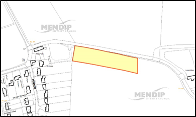
© Crown copyright and database rights 2021 Ordnance Survey 100019309.
Additional Information © Mendip District Council.
Context
This greenfield site is 0.5ha in size and currently in agricultural use. It is located at the northern end of the village, opposite existing development on the northern side of Back Lane. Further development lies to the west of the site on Wraxall Road, separated from the site by a traditional orchard.
Landscape & Ecology
The site lies in a predominantly rural context and development in this area of the village is largely sparse and scattered.
The site comprises improved grassland with a tree line/hedgerow along the northern edge and hedgerow on the western boundary. Biodiversity records indicate the presence of barn owls in the area but the site is not considered suitable habitat. There is a nearby roost of brown long-eared and serotine bats to the west. Lesser horseshoe bats are possibly present at low density and the site links to bat commuting structure to the west and north of Ditcheat. The site also lies adjacent to a traditional orchard.
The settlement is within an area where wastewater and other water flows may have a ‘likely significant effect’ on the Somerset Levels and Moors RAMSAR which is in an ‘unfavourable condition’. Development allocations should assess additional phosphate loading on the catchment of the designated area and a mitigation solution agreed to secure a ‘phosphate neutral’ position.
Highways
The site has access onto Back Lane and will need to meet highways standards on width and visibility. Footway connections into the village will also need to be considered.
Heritage
The site lies in relatively close proximity to protected heritage assets, specifically the Grade II* Ditcheat Manor (Formerly listed as Ditcheat House) and the Grade I listed Church of St Mary Magdalene.
Policy DT2: Development Requirements and Design Principles DIT009
Policy DT2: Land at Back Lane, Ditcheat (HELAA Site DIT009)
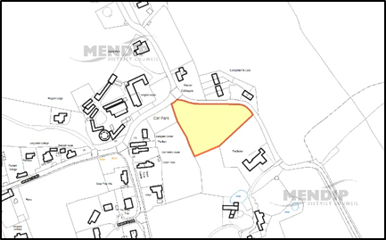
© Crown copyright and database rights 2021 Ordnance Survey 100019309.
Additional Information © Mendip District Council.
11.11.1 Doulting is a small village 2km east of Shepton Mallet on the A361. There are some extensive quarries around the village including those from which and later additions to Glastonbury Abbey were built.
Site Allocations
11.11.2 LPP1 designates Doulting is as a Secondary Village making it appropriate for development aimed at meeting more localised housing, business and service needs. It was expected to deliver 15 homes over the plan period.
11.11.3 Recent years have seen low levels of incremental development with completion and consent levels from 2006-2016 totalling 5 homes. Consequently, there is a residual level of 10 homes to be delivered through LPP2. No suitable sites have been put forward for allocation and it might be expected that some of the total will come forward from infilling. The Council will work with the Parish Council to develop opportunities for additional housing growth to meet need in the village.
Windfall development
11.11.4 Doulting continues to have an identified development limit. Therefore, over the lifetime of the plan additional small scale development can potentially come forward within this boundary.
Development Limit
11.11.5 The following amendments have been made to the development limit:
11.12.1 Draycott is located on the A371, 3kms from Cheddar and on the administrative boundary with Sedgemoor District. The village lies on the southern edge of the Mendip Hills AONB. Draycott is a compact village with development constrained by the Mendip Hills to the north and floodplain in the Cheddar valley to the south. The village has good access to Cheddar. The village and neighbouring Rodney Stoke has a long association with strawberry production.
Site Allocations
11.12.2 Draycott is designated as a Primary Village and the village is expected to deliver at least 65 new homes over the Local Plan period 2006-2029. 32 new homes have been built or permitted leaving 33 homes to meet the planned requirement.
11.12.3 Due to the number of homes still to be developed, and the level of past development, an allocation is proposed at Westfield Lane, combining two promoted sites, (DRAY004a and DRAY022). A comprehensive scheme is preferable with access via Cross Farm Road. However, if this is not deliverable, a limited development accessed via Westfield Lane may be considered, subject to highway assessment.
The allocated site includes HELAA sites DRAY004a and DRAY022
Windfall Development
11.12.4 Draycott continues to have an identified development limit. Over the lifetime of the plan additional small scale development could potentially come forward within this boundary.
Development Limit
11.12.5 No changes have been made to the development limit.
Context
Site DRAY004a is comprised of a residential property and a narrow field which joins onto a larger and more open area of fields to the north. Site DRAY022 is comprised of a dwelling fronting Westfield Lane with a field behind. This site is between site DRAY004a and development at South Close and North Close.
The site could provide for the residual housing requirement in the village and some additional homes above minimum requirement.
Landscape & Ecology
The site is visible in views of the village from the west, but will appear as the edge of the village. It is viewed across level agricultural land and does not have particular prominence. The site would add to the bulk of the village in any views from the levels to the south and the AONB to the north, but will appear as part of the developed area. The site is not prominent in the street scene or views within the village, although it is visible from the rear of a number of properties and as glimpses between buildings within the built up area.
There are several protected species on the site and it is partly within the Mendip Bat Consultation Zone. The habitat comprises semi or unimproved grassland subdivided by hedgerows potentially used by greater horseshoe bats. It is within Band B of the North Somerset and Mendip Bats SAC. Provisionally any masterplan should include 0.40ha of accessible replacement habitat. In combination effects with other developments affecting the SAC around Cheddar should be considered. Common pipistrelle, serotine, lesser horseshoe and the rare barbastelle bats are also potentially present at low density.
The potential impact of phosphates should be taken into account in mitigating the environmental impact of the development. However, wastewater flows from this settlement are not considered to be hydrologically linked to the designated RAMSAR site.
Heritage
While the site does not lie within a Conservation Area or in the vicinity of any designated heritage assets, any development should respect the local context and be sensitive to the rural character of the village
Highways
A suitable access will need to be provided to meet highway standards on width and visibility. The farm access from Baggs Lane will not be suitable. Capacity on the routes along Back lane and Westfield lane and Latches Lane is limited. Access should be considered via Cross Farm Road, although this will require the removal of one or two bungalows. Careful consideration of the impact of traffic on residential roads around the site and access to the A371 will be required.
DR1: Development Requirements and Design Principles
Policy DR1: Land at Westfield Lane, Draycott
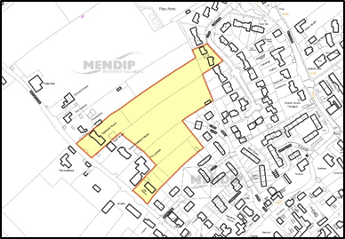
© Crown copyright and database rights 2021 Ordnance Survey 100019309.
Additional Information © Mendip District Council.
11.13.1 Evercreech is a large village around 3 miles south of Shepton Mallet. It is closely related to the smaller settlement of Stoney Stratton to the east. The southern part of the village around Queens Road and the Church is designated as Conservation Area and there are numerous listed buildings. There are more modern housing areas particularly to the north of the village, and an active employment site at Leighton Lane.
Site Allocations
11.13.2 LPP1 designated Evercreech as a Primary Village. It is expected to deliver a minimum of 70 new homes in the plan period. Recent years have seen significant development. Completion and consent levels from 2006-2017 have been very high at 161 homes. This is significantly more than the planned level of development for the village therefore there is no residual level of development to be delivered through LPP2. In line with this strategy no sites have been allocated in Evercreech.
11.13.3 The Greencore site in Evercreech closed in 2018. This is identified as an established employment site in this Plan under Policy DP25 and should be retained and re-marketed for employment uses in accordance with the policy. Alternative uses will only be considered acceptable once its re-use for employment has been fully explored to the satisfaction of the Council. Proposals for alternative uses of the site should focus on a mixed-use scheme and come forward through a development brief to be prepared with close engagement of the Parish Council, making provision for employment uses and community facilities. A mixed-use proposal including residential development will need to include phosphate mitigation.
Infrastructure
11.13.4 The village school has a deficit of places. Contributions for education may be sought from proposed developments in this area.
Windfall Development
11.13.5 Evercreech continues to have an identified development limit. Therefore, over the lifetime of the plan additional small scale development can potentially come forward within this boundary.
Development Limit
11.13.6 The following amendments have been made to the development limit:
11.14.1 Faulkland is a small village that lies within the parish of Hemington, close to Radstock and Midsomer Norton in Bath and North East Somerset.
11.14.2 Historically the village has been characterised by farming and coal mining. The A366 runs through the village.
Site Allocations
11.14.3 Faulkland is identified in LPP1 as a Secondary Village and because of the small size of the village and its rural character future housing numbers in the village were limited to 20. Recent years have seen high levels of development. Completion and consent levels from 2006-2017 have resulted in 36 homes being delivered. Therefore, there is no residual requirement to be delivered through LPP2. No sites have been allocated in Faulkland.
Windfall Development
11.14.4 Faulkland continues to have an identified development limit. Therefore, over the lifetime of the plan additional small scale development can potentially come forward within this boundary.
Development Limit
11.14.5 No amendments are proposed to the development limits other than to reflect committed development. There are two sites which have planning permission which are included in development limits south of West Farm and between Oaklea and Faulkland Farm. There is also a small change to include existing buildings at Ashgrove and The Beeches.
11.15.1 Holcombe is a former coalfield village which lies 10kms north-east from Shepton Mallet. The settlement is only served by minor roads and is 4kms from the A367.
Site Allocations
11.15.2 LPP1 designates Holcombe as a Secondary Village. It was expected to deliver 40 new homes. Recent years have seen relatively large amounts of development and to date, 42 homes have been delivered (2006-17). The planned level of development for the village has therefore been delivered and there is no residual level of development to be delivered through LPP2.
11.15.3 Access to the village is via minor roads and this, along with its rural nature and declining services, suggest it is not an appropriate location for substantial further development in the future. No sites are therefore allocated in Holcombe.
Infrastructure
11.15.4 The nearest primary schools are over capacity. Financial contributions for education may be sought from proposed developments in this area.
Windfall development
11.15.5 Holcombe continues to have an identified development limit. Therefore, over the lifetime of the plan additional small scale development can potentially come forward within this boundary.
Development Limit
11.15.6 The Development limit has been amended to include committed development on the north western edge of the village at Stratton Road.
11.16.1 Kilmersdon is a small village, around 2 miles south-east of Radstock and 6 miles north-west of Frome, served by minor roads. It is located around 2.7km from the A366 and A362 and around 3.7km from the A367. There are numerous listed buildings and much of the village is Conservation Area. The village is surrounded by open countryside.
Site Allocations
11.16.2 Kilmersdon was identified in LPP1 as a Secondary Village and because of the small size of the village and its rural character future housing numbers in the village were limited to 15. Recent years have seen steady development. Completion and consent levels from 2006-2017 have resulted in 15 homes being delivered. Therefore, there is no residual requirement to be delivered through LPP2. No sites will be allocated in Kilmersdon.
Infrastructure
11.16.3 The village school is over capacity and not capable of further expansion. Financial contributions for education may be sought from proposed developments in this area.
Windfall Development
11.16.4 Kilmersdon continues to have an identified development limit. Therefore, over the lifetime of the plan additional small scale development can potentially come forward within this boundary.
Development Limit
11.16.5 No amendments have been made to the development limits.
11.17.1 “The Lydfords” refer to the villages of East Lydford, West Lydford and Lydford on Fosse, all situated in the very south of the district. The villages are well connected by road, lying either on or close to the A37.
11.17.2 The Lydfords are within the Brue Lowlands Landscape Character Area, which is predominantly an open, relatively flat landscape with sparse settlement, low hedges and lias buildings.
Site Allocations
11.17.3 LPP1 identifies The Lydfords as a Secondary village with a requirement for 25 homes over the plan period. As of 31st March 2017, 22 houses had either been completed or consented. As the residual requirement has the potential to be accommodated within development limits over the plan period, no sites will be allocated in The Lydfords.
Development Limit
11.17.4 A change to the development limit has been made at Church Lane, East Lydford to reflect existing development.
11.18.1 Meare & Westhay lie to the west of the district close to the towns of Glastonbury & Street. Together they represent a significant sized settlement. They sit upon the Somerset Levels – an area at significant risk of flooding as well as being an important area for protected birds. The surrounding areas are also characterised by the history of peat working.
11.18.2 Meare & Westhay lie within the Westhay-Meare Island Landscape Character Area - a low ridge which contrasts with the neighbouring moors. Fields are generally small and hedged and fragments of orchards can be found around the settlements.
Site Allocations
11.18.3 LPP1 identified Meare & Westhay as a Secondary Village with a requirement for 40 homes over the plan period. As of 31st March 2017, 99 homes had either been completed or consented, more than double the requirement. There is therefore no need to allocate a site in Meare and Westhay.
Windfall Development
11.18.4 Meare & Westhay continue to have an identified development limit. Therefore, over the lifetime of the plan additional small scale development can potentially come forward within this boundary.
Development Limit
11.18.5 The development limits have been altered to reflect committed development to the south of The Levels and Bramble Close and at Chestnut Farm.
11.19.1 Mells is situated some 5km west of Frome, in the valley of the Mells Stream. The area has an abundance of industrial archaeology and is also of great environmental significance including forming part of an important habitat for bats. Most of the road approaches to the village descend steeply to the valley floor which is well wooded. The village is characterised by extensive areas of green space within its core, along the watercourse and on the southern valley side, at Mells and Little Green. A large part of the village is designated Conservation Area and there are numerous listed buildings, including the Parish Church and Mells Manor which are listed Grade I.
Site Allocations
11.19.2 LPP1 limited future housing numbers in the village to 10 due to the environmental, heritage and topographical constraints and the isolation of the village from main transport routes. Recent years have seen relatively low levels of windfall development with completion and consent levels from 2006-2016 totalling 5 homes. Consequently, there is a residual level of 5 homes to be delivered through LPP2. However, given the low level of windfall development that has come forward in recent years and the constraints on the village it is appropriate to allocate a small site to facilitate development.
Windfall Development
11.19.3 Mells continues to have an identified development limit. Over the lifetime of the plan additional small scale development could potentially come forward within this boundary.
Development Limit
11.19.4 No amendments have been made to the development limit.
Context
The site is 0.13 ha and lies between housing to the north and converted farm buildings to the south adjacent to the development limits. It is close to the core of the village.
Landscape & Ecology
The site is within the Mendip Bat Consultation Zone. Serotine bats, lesser spotted woodpeckers and greater horseshoe bats are present on the site. The site is surrounded to the north, west and south by hedgerow and trees that are likely to be used by commuting greater horseshoe bats and is within Band A of the Mells Valley SAC. Connectivity will need to be maintained. An area of replacement habitat for bats may be required pending bat surveys.
Heritage
The site is close to a number of listed buildings and the Conservation Area boundary and has boundary hedgerows which should be respected in any designs that come forward.
Drainage
The site is within a water source protection zone which should be addressed in any designs that come forward.
Coal
The site is within the coal consultation zone and this will need to be addressed.
ML1: Development Requirements and Design Principles
Policy ML1: Land at Park Hill (HELAA site MELLS002)
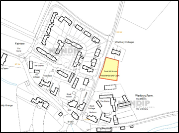
© Crown copyright and database rights 2021 Ordnance Survey 100019309.
Additional Information © Mendip District Council.
11.20.1 Norton St Philip is a medium sized village located 12km (9 miles) south of Bath and 11km (8 miles) north of Frome, situated around the junction of the A366 Wells to Trowbridge road and the B3110 route, about 1.5km west of the A36 (T) main route from Bath to Warminster. It occupies an elevated position on a pronounced west-facing ridge overlooking the valley of Norton Brook. The village’s position on a ridge and down its western slopes, means that it dominates its immediate surroundings and is visible from lower ground to the west. There are many older and listed buildings and much of the village is Conservation Area. The older buildings of High Street and The Plain form a strong skyline when viewed from the lower ground. The village lies adjacent to an area designated as the Bath & Bristol Green Belt.
Community Planning
11.20.2 A Neighbourhood Plan for the Parish Area of Norton St Phillip was submitted and examined in June/July 2019.
Site Allocations
11.20.3 Norton St Philip is identified in LPP1 as a Primary Village with a minimum housing requirement of 45 dwellings in Policy CP2. Completions and committed development in the plan period to date totals 105 dwellings, a 34% increase to dwelling stock. Given this level of growth, no sites were allocated in this village in the Submission plan. Following examination hearings, additional allocations were necessary to make the plan sound, specifically to address the requirement in Policy CP2 to provide 505 dwellings located adjacent to Midsomer Norton and Radstock and in settlements in the north/northeast of the district.
11.20.4 Land to the east of the Fortescue Fields development, off Mackley Lane, is identified as a suitable location for additional development. This location is not subject to designations in the Neighbourhood Plan. The land is outside but adjacent to the adopted development limit.
Windfall Development
11.20.5 Norton St Philip continues to have an identified development limit. Therefore, over the lifetime of the plan, additional small scale development can potentially come forward within this boundary.
Development Limit
11.20.6 The development limit has been amended than to reflect committed development at Longmead Close and to reflect existing development on the southern edge of Fortescue Fields.
Context
This site is 1.1 ha and lies outside of development limits to the south of the village, north west of Mackley Lane. It is a greenfield site consisting of fields and is adjacent to the Fortescue Fields development. It borders the B3110 and there is other residential development on the opposite side of this road. The land is raised above the level of surrounding road.
Highways
The site adjoins Mackley Lane with the potential for a suitable access from here. There is also potential to access the Laverton Triangle section of the site from Fortescue Fields. Mackley Lane is currently a lightly used rural lane and the need for improvements, including the junction with Townsend, should be considered. There are currently no footpath links and no footways on Mackley Lane. There is potential to link into the local footpath network and to provide convenient access to local facilities, including the playing field and school.
Landscape & Ecology
The north eastern part of the site is considered to be visually important - a gateway to the village and important to its setting. A bank of newly planted trees is also identified as important to the character and setting of the village and has the potential to reduce the sense of buildings being an incursion into open countryside. It would be necessary to retain the appearance of countryside at this gateway in order to mitigate the impact of development.
The south western part of the site is on the slopes forming the southern edge of the ridge on which Norton St Philip sits. Although the landscape setting on the ridge is important to the character of the village, the slopes here are less prominent than in other parts of the village.
The site lies within the outer area (Band C) of the Mells Valley and Bradford on Avon Bat consultation zones. Appropriate mitigation measures will be required.
Affordable Housing
A village survey has identified a need for an affordable housing format that allows for purchase as well as rental. Affordable housing formats that allow an element of purchase should be considered.
Heritage
Development should respect the local context and be sensitive to the location. The Norton St Phillip Conservation Area covers part of the Laverton Triangle site.
Flood Risk / Drainage Infrastructure
There is no known flood risk on the site. There has been significant development in the village in recent years and therefore it is possible that additional development will require drainage capacity improvements.
School Infrastructure
Norton St Philip is served by both Norton St Philip First School and Rode First School. Middle school provision is in Frome. At present, both of the First schools are relatively full but not at capacity. The number of pupils on the school roll is expected to fall over the next five years. Therefore, it is likely that the school would be able to accommodate growth from the identified allocation.
Policy NSP1: Development Requirements and Design Principles
Policy NSP1: Land at Laverton Triangle
© Crown copyright and database rights 2021 Ordnance Survey 100019309.
Additional Information © Mendip District Council.
11.21.1 Nunney is a medium sized village which lies 5kms southwest of Frome. Distinctive features include its castle, historic high street and location in the Nunney Brook valley. Most of the village falls within a Conservation Area. The main access to the village is from the A361 at Nunney Catch (1km from the village centre).
Site Allocations
11.21.2 LPP1 defined Nunney as a Primary Village and the village is expected to accommodate at least 55 new homes. Recent years have seen relatively low levels of windfall development with completion and consent levels from 2006-2017 totalling two dwellings. Consequently, there is a residual level of 53 homes to be delivered through LPP2. This will be addressed through allocation of land off Green Pits Lane. This site was subject to an outline planning permission (2014/0198/OTS) for the erection of up to 100 no. dwellings with vehicular access from Green Pits Lane and pedestrian/cycle access from Glebelands. This was dismissed on appeal. However, the site is suitable for a more limited scale of development to meet the settlement requirement.
Employment
11.21.3 A site at the Nunney Catch roundabout is identified as a Future Employment Growth Area for employment/distribution use (see Policy DP25).
Development Limit
11.21.4 No amendments have been made to the development limit.
Context
Flat field adjoining settlement boundary to the south of the village. The majority of site is currently used for agriculture.
Landscape & Ecology
While the site is not in a particularly sensitive or prominent position in landscape terms (and is relatively well screened at present), the site is currently rural and open in nature and development would have some landscape impact.
An Ecology Strategy on file was prepared for the previous application which was agreed subject to conditions. Surveys are now out of date which may require amending the strategy. The site is an arable field with a smaller field of unimproved grassland. It is within Band C of Mells Valley SAC. Provisionally a masterplan should include 0.28 ha of accessible replacement habitat (dependent on updated bat activity surveys).
Heritage
The village has a historic core with a number of Listed Buildings, a Conservation Area, Area of High Archaeological Potential and Scheduled Ancient Monument (Nunney Castle). However, the site lies some distance from the historic core. The Nunney Conservation Area is around 400m north of the site and separated by more recent housing development, including the Glebelands estate. The nearest listed building is not adjacent, but it is only 60m away, to the southeast at the Theobald Arms.
Highways
The site has a number of access options and will need to take account the width of Green Pits Lane. Accesses will need to meet standards on width and visibility and highway safety. Footway and cycle connections into the village will need to be considered. A comprehensive approach will be needed to provide safe access by a range of means (including by means other than private car).
Sewerage
There is an existing sewer which crosses the site which will require protection and easement. Local capacity is likely to exist within networks.
Surface Water Flooding
Environment agency determines site as Very Low Risk, but it is in close proximity to an area of High Risk, on the other side of the A361.
Policy NN1: Development Requirements and Design Principles
Policy NN1: Land at Green Pits Lane (HELAA site NUN001a)
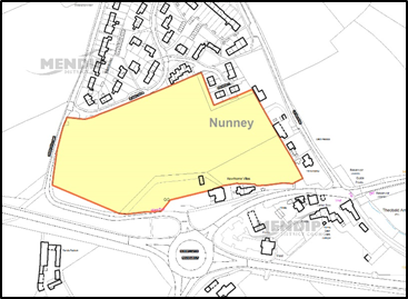
© Crown copyright and database rights 2021 Ordnance Survey 100019309.
Additional Information © Mendip District Council.
11.22.1 Oakhill is the main settlement in Ashwick Parish. The Parish also includes parts of Gurney Slade (see separate village profile with Binegar). The main access to the village is from the A367 which is a main route from Shepton Mallet to Radstock. The village has its origins in farming and mining, and also had a large brewery in the 19th century. The brewery buildings are still important to the character of the village. Pondsmead House and its estates are also a significant feature.
Infrastructure
11.22.2 The village school is over capacity and may not be capable of expansion.
Site Allocations
11.22.3 Oakhill is designated as a Secondary Village in the LPP1 and was expected to deliver a minimum of 40 new homes. To date, 49 have been built or permitted therefore there is no residual level of development to be delivered through LPP2. In line with this strategy no sites have been allocated in Oakhill.
Windfall Development
11.22.4 Oakhill continues to have an identified development limit. Therefore, over the lifetime of the plan additional small scale development can potentially come forward within this boundary.
Development Limit
11.22.5 The development limit has been amended to include development permitted at Galley Batch Lane.
11.23.1 Rode is a larger village in Mendip around five miles north-east of Frome and five miles south-west of Trowbridge. It is the easternmost settlement in Mendip lying within a mile of the Wiltshire border. It lies close to the junction of the main A36 (Bath – Salisbury) and the A361. There are two distinct clusters of development, with the medieval church and several old houses situated on the A361 and the main part of the village offset to the north, between the two main roads. The River Frome flows immediately to the west of the village, with a historically important crossing point at Rode Bridge. A large part of the village is designated as a Conservation Area and there are numerous listed buildings.
Community Planning
11.23.2 A Neighbourhood Plan for the village was ‘made’ in 2017.
Education
11.23.3 Rode is served by both Rode First School and Norton St Philip First School. Middle school provision is in Frome. Both of the First schools are relatively full but not at capacity. The number of pupils on the First school roll is expected to fall over the next five years. Financial contributions could be sought to provide additional capacity.
Highways
11.23.4 The Highways Agency have identified capacity issues on both A36 roundabouts which link to the village. Development proposals are subject to Policy DP27 - Highway Infrastructure Measures for Frome, Beckington and Rode. Major proposals which require a traffic impact assessment will need to take this into account and may be subject to development contributions to support strategic highway infrastructure.
Site Allocations
11.23.5 Rode is identified in LPP1 as a Primary Village with a minimum housing requirement of 65 dwellings in Policy CP2. Completions and committed development in the plan period to date total 79 dwellings, an 18% increase to dwelling stock. Given the level of growth above minimum requirements, no sites have been allocated in this village.
Windfall Development
11.23.6 Rode continues to have an identified development limit. Therefore, over the lifetime of the plan additional small-scale development can potentially come forward within this boundary.
Development Limit
11.23.7 Amendments to the development limits have been made to reflect committed development and to reflect minor alterations made by the Neighbourhood Plan. This includes a site under development at Church Farm and an amendment at Church Lane.
Local Green Spaces
11.23.8 The Neighbourhood Plan has designated the following sites as Local Green Spaces and they are shown for information only:
LGSRODE001 front of Langham House
LGSRODE002 Rode Village Green
LGSRODE003 Browns Ground
LGSRODE004 Recreation Ground
LGSRODE005 Pathway to Rockabella
LGSRODE006 Greenway to Beckington
Existing Employment Areas
11.23.9 There is an existing employment area at Claygate Lane which was relocated from Church Farm.
11.24.1 Stoke St Michael is a small rural village in a parish which includes the hamlets of Fosse, Midway, Three Ashes, Withybrook and East End. It is set in the characteristic East Mendip landscape of lush pasture, streams, swallets, wooded valleys and quarries. The village lies within a complicated network of minor roads, approximately 3km from the A367 and A361 and 4km from the A37.
Infrastructure
11.24.2 The village school is close to capacity and financial contributions for education may be sought from proposed developments in the area.
Site Allocations
11.24.3 LPP1 designated Stoke St Michael as a Primary Village. It is expected to deliver a minimum of 45 new homes and to date, 12 homes have built and a further 3 granted permission or under construction. Given the residual requirement for 30 homes in the village, it is considered that an allocation would be appropriate.
11.24.4 Stoke St Michael continues to have an identified development limit. Therefore, over the lifetime of the plan additional small scale development can potentially come forward within this boundary.
Development Limit
11.24.5 An amendment has been made to the development limit to reflect committed development between Gooseacre and 1 Mendip Road and to include Gooseacre as a consequence of the infill development.
Context
The site is on the western edge of the village and is flat agricultural land. It is adjacent to the village playing fields to the south and the primary school to the east. It is bounded on two sides by mature hedgerow and trees and on the third by an old breeze block wall, on the boundary with the recreation ground.
Landscape & Ecology
The site is in an area of elevated, flat and open countryside adjacent to the edge of village. Careful design will be required to mitigate any landscape impact.
Part of the SSSI St Dunstan’s Well and Mells Valley SAC (designated for its importance to the greater horseshoe bat) lies approximately 250m to the west of the site and existing hedgerows could potentially support hazel dormice. New and retained hedgerows should be protected by additional planting a buffer of meadow grassland, and not incorporated into residential garden boundaries. To reduce the potential risk to SAC habitat, a natural area for recreation with footpaths for dog walking/exercising (including secure areas for dogs to be let off leads) should be attached to the proposed site.
Common and soprano pipstrelle, serotine, lesser horseshoe, natterer’s and the rare barbastelle bats are also potentially present, commuting along the hedgerows at low density.
Highways
The preferred point of access is onto Frog lane and will need to meet highways standards on width and visibility. Parts of Frog Lane are narrow. Footpath connections into the village will also need to be considered and there is potential to link into the existing footpath network converging at the Recreation Field.
Infrastructure
The village school is close to capacity and financial contributions may be required to extend the school (if feasible) or funding for school transport.
Drainage
The site lies in Zone 1 of a groundwater source protection zone.
Policy SS1a: Development Requirements and Design Principles
Policy SS1a: Land east of Frog Lane (HELAA Site SSM009)
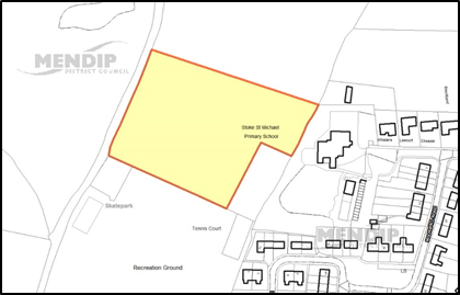
© Crown copyright and database rights 2021 Ordnance Survey 100019309.
Additional Information © Mendip District Council.
11.25.1 Walton is a large village of around 400 homes lying between the Somerset Levels and the Polden Hills. Walton lies within the Polden Ridge Landscape Character Area. This area is characterised by the large open fields which surround the village.
11.25.2 The village is bisected by the A39 which is a key route connecting the district to the M5. A safeguarded route for a bypass to the north of Walton is shown in the adopted plan.
Neighbourhood Plan/Wider Parish Area
11.25.3 The Parish is a designated Neighbourhood Plan Area. The wider Parish area includes the strategic housing site west of Street and associated land identified as Future Growth Area. The proposals for the land west of Street are included in the Street section in Policy ST3 and shown on the map on Page 73.
Site Allocations
11.25.4 LPP1 identifies Walton as a Secondary village with a requirement for 40 homes over the plan period. As of 31st March 2017, 54 homes had either been completed or consented. This is more than the planned level of development for the village. There is a no residual level of development to be delivered through LPP2. No sites have therefore been allocated in Walton.
Windfall Development
11.25.5 Walton continues to have an identified development limit. Therefore, over the lifetime of the plan additional small scale development can potentially come forward within this boundary.
Development Limit
11.25.6 No amendments have been made to the development limits.
11.26.1 West Pennard parish includes the hamlets of Coxbridge and Woodlands. The village is well connected in terms of roads with the A361 running through the village.
11.26.2 The majority of the village lies within the Baltonsborough Farmlands and Orchards landscape character area. The village does contain a number of orchards – one of the most dominant characteristics of this landscape character area and these stand out in contrast to the adjacent moors.
Infrastructure
11.26.3 The village school is over capacity and a feasibility study would be needed to test whether additional demand could be accommodated. Financial contributions for education may be sought from proposed developments in this area.
Site Allocations
11.26.4 LPP1 identifies West Pennard as a Secondary village with a dwelling requirement of 25 homes over the plan period. As of 31st March 2017, 16 homes had either been completed or consented, leaving a remainder of 9 to be delivered.
11.26.5 West Pennard continues to have an identified Development Limit. Therefore, over the lifetime of the plan additional small scale development can potentially come forward within this boundary. An extension to the development at rear or Avalon will allow for up to 3 houses, leaving a remainder of 6 to be delivered over the plan period within the existing development boundary.
Development Limit
11.26.6 Amendments to the development limits to take account of committed development at Bishops Orchard and south of Fallowfields and include a small site for up to 3 dwellings at the rear of Avalon have been made.
11.27.1 Westbury-sub-Mendip is a medium sized village within the southern slopes of the Mendip Hills Area of Outstanding Natural Beauty and extending down to the edge of the Somerset Levels. It is located along the A371, around five miles from Wells and six miles from Cheddar.
11.27.2 Westbury-sub-Mendip is designated in the LPP1 as a Primary Village. It is expected to deliver at least 50 new homes over the Local Plan period 2006-2029. 38 houses are still to be delivered.
Site Allocations
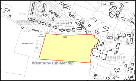
11.27.3 Due to the number of homes still to be developed, and the level of past development, an allocation is proposed on Land at Court House Farm (off Roughmoor Lane) (part of HELAA site WSM006). This is a suitable site, which could deliver the required number of homes but remain proportional to the size, needs and limitations of the settlement. Traffic generation will need to be carefully considered, as the access from Roughmoor Lane onto the A371 will require assessment. There is also scope to include community facilities on the site, which is adjacent to the village playing fields. The Parish Council have identified a need for improved community facilities including a village hall.
Windfall Development
11.27.4 Westbury Sub Mendip continues to have an identified development limit. Over the lifetime of the plan additional small-scale development could potentially come forward within this boundary to meet the residual requirement.
Development Limit
11.27.5 Amendments at Torlea, Wells Road and at Stable Cottages to allow for committed development have been made to the development limit.
Context
The site is part of a large single field adjacent to but outside the development limit on the south western edge of the village. The site contains a number of farm buildings on its eastern side, abuts sporadic mixed development along its eastern edge (including undeveloped areas) and abuts open countryside on its western and southern edges. There is also a playing field adjacent to the western edge.
The site is well related to the village and accessible to most village facilities. It is enclosed by development on two sides and while it is visible across open land to the south, it is not prominent in the landscape. The site could provide for the residual housing requirement in the village. Traffic generation and access onto the A371 will need to be carefully considered. There is also scope to include community facilities on the site, which is adjacent to the village playing fields. Additional land is included in the site area to allow for this.
Landscape & Ecology
The site is visible in the landscape across open and gently sloping fields to the south. It is visually well contained from the east, west and north. It adjoins the edge of the settlement and a well-designed scheme would read as the edge of the village. The site would have an impact on views from Roughmoor Lane across currently open farmland. The site would also be visible from Lodge Hill industrial estate to the south of the village, but appear as distant development.
The site is part of a large arable field with hedgerow to the west, located in Band C of the North Somerset and Mendip Bats SAC. Provisionally any masterplan should include 0.13 ha of accessible replacement habitat. In combination effects with other developments affecting the SAC around Cheddar should be further investigated. Common pipistrelle, serotine, lesser horseshoe and the rare barbastelle bats are also possibly present at low density.
The potential impact of phosphates should be taken into account in mitigating the environmental impact of the development. However, wastewater flows from this settlement are not considered to be hydrologically linked to designated RAMSAR site.
Heritage
The north-east corner of the site falls within the Westbury-sub-Mendip Conservation Area. There are a number of listed buildings nearby - to the east at Grade II Court House Farm House, Grade II* Church of St Lawrence, and Grade II Westbury House. The north-east corner of the site falls within the Area of High Archaeological Potential.
Highways
The site can be accessed from Roughmoor Lane or onto the A371 (Stoke Road). Further investigation will be required to establish access options.
Policy WM1: Development Requirements and Design Principles
Policy WM1: Land at Court House Farm (HELAA site WSM006)
© Crown copyright and database rights 2021 Ordnance Survey 100019309.
Additional Information © Mendip District Council.
11.28.1 Wookey is large village with approximately 1,300 residents and 300 homes. It lies on the River Axe and while served only by minor roads, lies approximately 750m to the A371 and good connections with Wells. There are numerous listed buildings and the scheduled ancient monument at Court Farm which influence the character of the village. There are also areas of more modern housing to the north and west of the village.
Site Allocations
11.28.2 Wookey was identified in LPP1 as a Secondary Village and was expected to deliver a minimum of 40 homes during the plan period. There have been large amounts of development in the village in recent years with 68 homes built or approved to date. This is significantly more than the planned level of development for the village. There is no residual level of development to be delivered through LPP2. In line with this strategy no sites have been allocated in Wookey.
Windfall Development
11.28.3 Wookey continues to have an identified development limit. Therefore, over the lifetime of the plan additional small scale development can potentially come forward within this boundary.
Development Limit
11.28.4 The development limit has been amended to include development permitted at Henley Lane and Chapman’s Close.
11.29.1 Wookey Hole is a small village of less than 200 homes which forms part of the St Cuthbert Out Parish. While connected only by minor roads, the village is only 3km from the City of Wells.
11.29.2 Wookey Hole is home to the popular Wookey Hole Caves tourist site and the Monarch's Way and Mendip Way long-distance footpaths pass through the village. The area borders an Area of Outstanding Natural Beauty and is of great environmental significance, including forming part of an important habitat for bats.
Site Allocations
11.29.3 Wookey Hole was identified in LPP1 as a Secondary Village. The Local plan housing requirement is limited to 15 due to the small size of the village and the environmental sensitivity. 16 dwellings have been built or permitted to date. Due to the level of past commitments and Wookey Hole’s environmental significance (including falling within the Mendip Bat Consultation Zone and bordering the AONB) no sites are allocated.
Windfall Development
11.29.4 Wookey Hole continues to have an identified development limit. Therefore, over the lifetime of the plan additional small scale development can potentially come forward within this boundary.
Development Limit
11.29.5 No amendments have been made to the development limits.
< Previous | ^ Top | Next >