
10.1 Frome
10.2 Glastonbury
10.3 Street
10.4 Shepton Mallet
10.5 Wells
10.6 Midsomer Norton
10.1.1 Frome is the largest town in Mendip, with a population of approximately 27,000 people. It is a vibrant town offering a good range of services and shopping, including a strong independent retail sector.
10.1.2 Frome is also known for its thriving creative sector and is home to two theatres, a cinema and a concert venue. The arts are prominent in the town and the Frome Festival and local markets attract performers and visitors throughout the year.
10.1.3 Frome is designated as a principal settlement in the LPP1, serving a market town role to its wider rural catchment area. A vision and development policies for Frome are set out in LPP1 Core Policy 6: Frome Town Strategy. The policy promotes redevelopment in the town centre (at Saxonvale) and greenfield sites at Southfield Farm and at the Mount (to the east and south east of the town). Commerce Park is identified as the key employment site with future capacity.
10.1.4 In the town centre, Saxonvale remains the significant opportunity for mixed-use development. A more specific policy is included in this Plan to clarify the intentions for this site. Both greenfield sites allocated in LPP1 are under construction.
10.1.5 The opening of the Steiner school has improved the overall capacity of school provision. Financial contributions may be sought to ensure delivery of additional primary places in the medium to long term.
10.1.6 Both Mendip District Council, Somerset County Council (as highways authority) and the Highways Agency are aware of capacity issues on key junctions through the town and impacts on traffic affecting the A36. This is addressed by Policy DP27 which requires consideration of cumulative impacts from major development and contribution and/or provision of infrastructure measures.
10.1.7 Frome Town Council have a Neighbourhood Plan in place. The "Neighbourhood Plan for Frome 2008 -2028" does not make housing or employment land allocations, but contains a number of objectives and policies relating to:
10.1.8 The Neighbourhood Plan for Frome and associated documents are available on the Council’s website: www.mendip.gov.uk/fromeneighbourhoodplan. A Town Design Statement for Frome has been adopted as a Supplementary Planning Document. This outlines the important features of Frome to be protected and includes a number of guidelines relating to design. The Design Statement can be viewed on the Council’s website: www.mendip.gov.uk/frometds.
10.1.9 Local Plan Part I sets out that Frome should deliver a minimum of 2300 new homes over the plan period. Compared against completions and current commitments, there is a shortfall of 309 dwellings against the residual requirement. There is a need to allocate additional housing sites in the town and to contribute to the district-wide housing supply.
10.1.10 Frome is the largest of the Mendip towns and has good prospects for growth and delivery. There has been an average net gain of 96 homes a year since 2006, on track with the minimum delivery rate set out in LPP1.
10.1.11 Additional allocations are proposed to the southwest of the town based on the sustainability appraisal. A site is also allocated for self and custom-build development in response to the aspirations of the neighbourhood plan and work by Frome Town Council to demonstrate local demand for this type of housing. Other windfall sites are expected to come forward within development limits.
10.1.12 Local Plan Part I calls for 20.2ha of employment land to be delivered in a variety of mechanisms, including development of the allocated site at Commerce Park, refurbishment or mixed-use development of existing sites, provision of office and workshop space in the town centre and provision for sites on the fringes of the town. A number of specific allocations are made including a Future Employment Growth Area to extend Commerce Park.
10.1.13 The following sites are allocated for development under the following policies:
- FR1 - Saxonvale (HELAA site FRO009) – Mixed use
- FR2 - Land E and W. of Sandy’s Hill Lane (HELAA site FR0152) – Mixed Use
- FR3a - Land South of Little Keyford and The Mount (HELAA site FRO001, FRO150 and FRO150a) – Housing
- FR7 - Land at Little Keyford (HELAA site FRO004) – Self & Custom-build Housing
- FR8 - Marston Gate (HELAA site FRO012M) - Employment
10.1.14 South of site allocation FR3a, land is highlighted as a Future Growth Area (FGA) in Local Plan Part I, south to Birchill Lane and west of Feltham Lane. Taking into account the proposed allocations, development of this area is likely to require a more comprehensive approach – particularly in terms of infrastructure, highway access and landscape assessment. The future of this location will therefore be re-assessed in the context of the future Plan Review. The FGA designation has been deleted from the Policies Map.
10.1.15 Changes to the Frome development limit to reflect committed development at Egford Lane and Gibbet Hill and sites allocated for development have been included on the Policies map.
Context
The site is 5.49ha of brownfield land immediately south of the River Frome. The historic core of Frome is immediately to the west, the river and mineral railway bound the site to the north. To the east land has been redeveloped for housing at River’s Reach. Historic Vicarage Street runs along the southern boundary. The site is largely occupied by derelict industrial buildings, although there are a number of buildings, some of which are listed. The Silk Mills Studio occupies a listed building on the site. There is also a town centre car park and an operational abattoir on the site.
The development area has been revised based on land now in public ownership and the Council will be working to secure early redevelopment. The site is allocated for a mixed-use neighbourhood including flexible commercial/employment space, high quality public realm, homes for all ages and parking. The mix of uses will be determined through master planning work but could be expected to deliver at least 250 homes. The masterplan should draw on the Planning Brief and Design Code adopted by the Council in 2005.
FR1 falls within a wider redevelopment area identified in LPP1 Policy CP6c: Masterplanning and submitted proposals should facilitate a seamless transition from the existing town centre and demonstrate that proposals will not create a competing or isolated destination.
Landscape & Ecology
Some investigation has already been carried out for the site, and there is evidence of protected species including bats, reptiles (slow worm), badgers and invertebrates. These should be further surveyed and protected within any scheme. Trees and woodland, scrub and the river also provide wildlife habitats. These should be replaced and enhanced within any scheme. Japanese Knotweed has also been noted on the site, and this will need to be removed.
The River Frome running through the site provides a wildlife habitat and is an important landscape feature of the site. This area could provide for attractive recreational open space alongside the river. The recreational value of the area would be enhanced by strong linkages to other nearby open spaces.
Heritage
There are several listed buildings and a number of historic buildings worthy of retention on the site. The site is partially within the Conservation Area and adjoins the historic core of Frome. Any proposals should be informed by and complement the historic character of Frome.
Flooding
The site is adjacent to the River Frome and any scheme will need to make provision for flooding, ensuring that the new development is secure from flooding and that flooding elsewhere is not made worse. Any scheme will need to meet the requirements of the Environment Agency to address both fluvial flooding and surface water drainage.
Retaining Walls
There are significant differences in level on some parts of the site and all retaining structures will need to be assessed.
Contamination
There is potential for contamination on the site from previous industrial uses. This will need to be assessed in any scheme.
Highways & Infrastructure
Highways assessments show that the capacity of the road network around the site is limited. Further investigation of off-site infrastructure requirements will be needed and any proposals should reflect the limitations of the site’s location. The site is close to town centre amenities and there are opportunities to provide for increased walking and cycling.
Car Parking
Parts of the site are currently used to provide town centre car parking. This should be retained or replaced within any scheme and additional town centre parking provided as appropriate.
Policy FR1: Development Requirements and Design Principles
Policy FR1: Saxonvale (HELAA site FRO009)

© Crown copyright and database rights 2021 Ordnance Survey 100019309.
Additional Information © Mendip District Council.
Context
The site is 12.4ha and an undeveloped area adjoining the Wessex Fields trading estate and extending further south adjoining Sainsbury’s. It lies outside but adjacent to development limits. It is allocated for mixed use, including at least 4.5ha for employment use.
Highways
The main access to the site is via the Marston Lane / Sandy’s Hill Lane Roundabout. This lane would need complete upgrading to highway standards. The impact on surrounding junctions would also need to be assessed including Little Keyford Lane/B3092.
Landscape & Ecology
The site adjoins the built up area, and is bounded by employment development on two sides and open fields with a scattering of housing on two sides. The site is, for the most part, visually well contained. There is a stepping stone for broadleaved woodland on the extreme southern edge of the site. Barn owls, a Schedule 1 and s41 bird, may hunt over the site north of Sandy’s Hill Lane.
The site lies within the outer consultation zone (Band C) of the Mells Valley SAC. Greater horseshoe bats have been recorded just to the south of the site and a good diversity of other species. Land north of Sandy’s Hill Lane (semi improved grassland) provide better quality foraging habitat than the south. Artificial lighting and loss of hedgerows may also be an issue. Provisionally, a masterplan should include 1.82 ha of replacement habitat.
Heritage
The site adjoins industrial development on two sides but there are older houses and some attractive countryside to the east. The site forms a back drop to the listed buildings to the east. There are a total of 6 listed buildings at Keyford House, Gurnville Cottages and Little Keyford.
Policy FR2: Development Requirements and Design Principles
Policy FR2: Land north and south of Sandy’s Hill Lane (HELAA site FRO152M)

© Crown copyright and database rights 2021 Ordnance Survey 100019309.
Additional Information © Mendip District Council
Context
The development allocation comprises three fields totalling 10 ha adjoining the B3092. Parts of the site close to the skyline and extend onto sloping land.
Masterplanning
Masterplanning for the entire site should be carried out prior to grant of planning permission for any part of site FR3a. The masterplan should include one or more indicative layouts covering:
The masterplan could also show housing layouts (market and affordable). Highways masterplanning should also include the potential to improve the accessibility of site FR7.
Proposals should also be supported by technical studies to demonstrate how the following issues will be addressed: drainage, sustainable transport including bus links, landscape impact and biodiversity.
Landscape & Ecology
There is potential for development to impact on the skyline and development will need to take into account where the allocation extends onto the southern slopes. Local habitats comprise semi improved grassland and arable land. The allocation is within Band C of Mells Valley SAC. There is potentially a good diversity of bats including common and soprano pipistrelle, serotine, noctule, lesser horseshoe and the rarer barbastelle and greater horseshoe are potentially present at low density. Barn owls, a Schedule 1 and s41 bird, may hunt over the site.
Provisionally 1.2ha of replacement habitat should be provided across the site as mitigation for impacts upon the SAC. Where plots are delivered by different developers a collaborative and coordinated approach to the delivery of bat replacement habitat that is accessible to greater horseshoe bats needs to be agreed. The precise quantum of replacement habitat should also be informed by the findings of detailed habitat assessment and bat survey work which must be completed for each site to inform the Masterplan and prior to any application being submitted.
Heritage
While the site does not lie within a Conservation Area or close to any designated heritage assets any development should respect the local context and be sensitive to the location.
Drainage
A master planning approach should be taken to provision of drainage infrastructure. It is likely that foul water flows will need to be pumped to the existing sewer network.
Highways
A master planning approach should be taken to provision of infrastructure for this and adjoining sites, including those east of the B3092. Access points will need to meet highways standards. Footway linkages will need to be considered as well as sustainable transport measures.
Policy FR3a: Development Requirements and Design Principles
Policy FR3a: Land at Keyford Field (HELAA Sites FRO001, FRO150 and FRO150a)

© Crown copyright and database rights 2021 Ordnance Survey 100019309.
Additional Information © Mendip District Council.
Context
The site is 0.73ha and is a field adjoining the development limit off Little Keyford Lane. It is bounded by development to the north and listed buildings to the west. There is a driveway accessing the listed buildings with a number of low stone walls and an avenue of pollarded trees to the south. While the site is adjacent to Little Keyford Lane to the east, there is a line of protected trees (with TPO) along this frontage. The trees are on top of a high bank and close together. The site has been promoted for self-build.
The site is not a preferred option arising from the sustainability appraisal but provides an opportunity to deliver self-build and address specific housing needs which meet objectives in the Frome Neighbourhood Plan.
Landscape & Ecology
Trees protected under a TPO are an important landscape feature, visible for some distance. The site is otherwise visually well contained.
Habitat is probably semi or unimproved grassland potentially used by greater horseshoe bats. There is a good diversity of bats including common and soprano pipistrelle, serotine, noctule, lesser horseshoe and the rarer barbastelle and greater horseshoe are potentially present at low density. Within Band C of Mells Valley SAC. Provisionally a masterplan should include 0.18 ha of accessible replacement habitat. Barn owls, a schedule6 and s41 bird, may hunt over the site.
Heritage
The site is close to three listed buildings. The entrance driveway to the south of the site is a distinctive feature, affording views of the listed buildings and its low stone walls and pollarded trees contribute to its setting.
Highways
A masterplanning approach should be taken to provision of infrastructure for this and adjoining sites. This may help to resolve existing access issues to the site.
Policy FR7: Development Requirements and Design Principles
Policy FR7: Land at Little Keyford (HELAA site FRO004)

© Crown copyright and database rights 2021 Ordnance Survey 100019309.
Additional Information © Mendip District Council.
Context
The site is 1.46ha and is on the edge of the built-up area adjoining Sainsbury’s, south of the Marston trading estate. It adjoins but is outside development limits. It is at the extreme southern edge of the town and is distant from many facilities.
Highways
The site has access onto Marston Road. The access point will need to meet highways standards on width and visibility. A right hand turn lane should be considered.
Landscape & Ecology
The site is relatively well contained visually and does not have extensive views, although it would be visible from the south, appearing as the edge of the built-up area.
This site has previously undergone a HRA and greater horseshoe bats are present on site, commuting. The site lies within Band B of the Mells Valley SAC and an area of 0.18ha will be required as replacement habitat.
Heritage
While the site does not lie within a Conservation Area or close to any designated heritage assets, any development should respect the local context and be sensitive to the location.
Policy FR8: Development Requirements and Design Principles
Policy FR8: Land at Marston Gate (HELAA site FRO012M)

© Crown copyright and database rights 2021 Ordnance Survey 100019309.
Additional Information © Mendip District Council.
10.2.1 Glastonbury is the smallest of the five Mendip towns with a population of just over 8,400 people. It is also the most environmentally constrained as it is surrounded by high quality landscape and extensive floodplain.
10.2.2 Glastonbury’s rich history and heritage, including features such as Glastonbury Tor and Wearyall Hill, draws many tourists to the town.
10.2.3 It is one of the smaller retail centres in the district and mainly caters for local needs and the tourist market. It is dominated by independent retailers and traders with its alternative shops being a feature of the town. The town has a strong relationship with nearby Street for work and also access to shops and services.
10.2.4 Glastonbury is identified LPP1 as a principal settlement. A vision and development policies for the town are set out in LPP1 Core Policy 7: Glastonbury Town Strategy. The policy promotes opportunities within development limits.
10.2.5 A Neighbourhood Plan is being prepared for Glastonbury and the Neighbourhood Area has been designated. Work on the plan is ongoing.
Site Allocations
10.2.6 Core Policy 7 indicates 1,000 new homes are to be delivered over the plan period.
Compared ag ainst completions since 2006 and current commitments of 869 dwellings, there is a shortfall of 131 dwellings against the residual requirement. There is a need to allocate additional sites in the town.
10.2.7 Five of the sites submitted through LPP2 are considered to be suitable for allocation. These sites are capable of delivering a minimum of 167 homes. Additional windfall sites would be expected to come forward within development limits.
10.2.8 A site for Travellers is allocated at Morlands. While this site has constraints, the allocation will address a significant unmet need for pitches identified in LPP1. A joint living spaces panel involving Mendip, the Glastonbury Town Council and Somerset County Council has been established to consider solutions to both temporary and permanent accommodation needs in the town including travellers and other groups.
10.2.9 Expansion of existing employment areas in the town are constrained by flood zones and a careful balance has been taken in allocating land for housing currently in employment use and reducing the area of additional land available at Morlands in Policy GL5. Further work will be undertaken as part of the future Plan Review on flood risk to explore additional employment that might come forward around the town.
10.2.10 Glastonbury is within an area where wastewater and other water flows may have a ‘likely significant effect’ on the Somerset Levels and Moors RAMSAR which is in an‘unfavourable condition’. Development allocations should assess additional phosphate loading on the catchment of the designated area and a mitigation solution agreed to secure a ‘phosphate neutral’ position.
10.2.11 The following sites are allocated for development under the following polices:
- GL1 - Glastonbury Highway Depot and GL1a Avalon Motors (HELAA Site GLAS001 and GLAS001a) – Housing
- GL2 - Allotments, Lowerside Lane (HELAA Site GLAS019) – Housing
- GL3 - Garage site, Frogmore, Street Road (HELAA Site GLAS027) – Housing
- GL4 - Lintells and Avalon Garage (HELAA Site GLAS055/GLAS121) – Housing
- GL5 - Land at Morlands – Travellers and Employment
10.2.12 Amendments to the development limits to reflect committed development on land northwest of the A39 and at West Mendip Hospital / Uppingstock Farm and sites allocated for development have been included on the Policies Map.
Context
The site is 1.95ha and is currently a depot and offices located behind residential development on the Wells Road. The site has a strong tree lined southern boundary. Access to the site is through the Avalon Motors site (GLAS001a). Development would need to ensure relocation of depot functions to an alternative site and agreement on access arrangements. The site is well located for access to town centre facilities and is in close proximity to bus stops on Wells Road. It is well integrated into existing residential development although some noise mitigation measures may be needed as the site adjoins a haulage yard.
Landscape & Ecology
The site borders Edmund Hill which forms part of the Glastonbury Special Landscape Feature. However, as the site is already developed as a highways depot and assuming the site is designed appropriately and sensitively, redevelopment would not further encroach on the SLF area or have detrimental landscape impact. Consideration of protected species (specifically the barn owl) will also be needed in any redevelopment. Pipistrelle and brown long-eared bats are likely to be present in low numbers.
Heritage
While the site does not lie within a Conservation Area or close to any designated heritage assets, any development should respect the local context and be sensitive to the location.
Policy GL1: Development Requirements and Design Principles
Policy GL1: Glastonbury Highway Depot (HELAA site GLAS001)

© Crown copyright and database rights 2021 Ordnance Survey 100019309.
Additional Information © Mendip District Council.
Context
The site is 0.14ha and is currently a garage on Wells Road. Access to GLAS001 is through the garage. Development would need to ensure relocation of the existing business or rationalisation of the site as well as consideration of the constraints identified. This site is well located within the existing development limits with good access to services and bus links. Redevelopment of the site could be well-integrated into the existing urban form and provide access for redevelopment of the Highways Depot behind. Appropriate noise mitigation measures may be needed as the site adjoins a haulage yard, as well as potential land remediation measures.
Landscape & Ecology
The site is in relatively close proximity to the Glastonbury Tor Special Landscape Feature, but a sensitively designed redevelopment should not impact on this. The site’s impact on the Local Wildlife Site 90m to the north-west must also be considered. Pipistrelle and brown long-eared bats are likely to be present in low numbers.
Heritage
While the site does not lie within a Conservation Area or close to any designated heritage assets, any development should respect the local context and be sensitive to the location.
Policy GL1a: Development Requirements and Design Principles
Policy GL1a: Avalon Motors (HELAA site GLAS001a)

© Crown copyright and database rights 2021 Ordnance Survey 100019309.
Additional Information © Mendip District Council.
Context
The site is 1.54ha and is currently well-used allotments owned by Glastonbury Town Council. The site lies adjacent to the A39 and is currently accessed by Lowerside Lane.
This site could deliver housing in a logical extension to the adjoining large site which already has planning permission (2013/2618/OTS) and could potentially offer additional options for access. However, it would result in the loss of well-used and mature allotment land (designated Recreation Space under Policy DP16). Ordinarily, allocations affecting designated recreation spaces would not be acceptable, but the constraints around Glastonbury are so significant that this site is one of few viable options to provide for the housing needs of the town. Alternative provision will be made to ensure the loss of allotments is mitigated.
Landscape & Ecology
The Glastonbury Conservation Area Appraisal states that the landscape setting of Glastonbury from the west is characterised by the town appearing as an island almost surrounded by the flat watery Somerset Levels on three sides. Development of this site could encroach on this sense of an island rising from the levels by increasing the built up area on the levels to the west of the town. The landscape impact of this site should be carefully considered in any scheme brought forward as it lies in the predominantly flat and agricultural area west of the A39.
The allotment gardens are likely to support slow-worms. Common and soprano pipistrelle and brown long-eared bats are potentially present in low numbers.
Heritage
While the site does not lie within a Conservation Area or close to any designated heritage assets, any development should respect the local context and be sensitive to the location with particular regard to the impact on views of the distant Tor.
Flooding
Pockets of flood zone 2 also cover much of the site and appropriate consideration of this will be essential. Part of the northern end of the site is in flood zone 3 and development of this area should be avoided. The site is surrounded by flood zone and this should be carefully assessed in any scheme.
Highways
Opportunities to create additional options to access this and the adjoining site which has planning permission should be fully assessed.
Policy GL2: Development Requirements and Design Principles
Policy GL2: Allotments, Lowerside Lane (HELAA site GLAS119)

© Crown copyright and database rights 2021 Ordnance Survey 100019309.
Additional Information © Mendip District Council.
Context
The site is 0.14ha and it is currently a garage on Street Road. It is within the development boundary and would relate well to existing residential development. It is situated within reach of the town centre and amenities. However, the entire site is designated as contaminated land.
Heritage
The site is within the Glastonbury Conservation Area and is listed as a negative feature in the Street Road Character Area of the Glastonbury Conservation Area Appraisal. A well-designed redevelopment could enhance this area. The current use is incongruous with the character of its surroundings which are typically gable-fronted Edwardian buildings. The site is close to an Area of High Archaeological Potential.
Policy GL3: Development Requirements and Design Principles
Policy GL3: Frogmore Garage (HELAA site GLAS027)

© Crown copyright and database rights 2021 Ordnance Survey 100019309.
Additional Information © Mendip District Council.
Context
The site is 0.6 ha and comprises a garage and separate car repair workshop to the rear. It is well integrated with the existing urban form and lies in close proximity to bus stops on Wells Road and within reasonably close proximity to the town centre and amenities. Well-designed redevelopment of this site could enhance the street scene. The site is designated as contaminated land and noise mitigation measures will need to be considered as the site adjoins a haulage yard.
Landscape & Ecology
The site does not directly adjoin, but it is in reasonable proximity to, the Glastonbury Tor Special Landscape Feature and any design should ensure there is no adverse impact on this. Pipistrelle bats are likely to be present in low numbers.
Heritage
While the site does not lie within a Conservation Area or close to any designated heritage assets, any development should respect the local context and be sensitive to the location.
Policy GL4: Development Requirements and Design Principles
Policy GL4: Lintells Garage, Wells Road (HELAA site GLAS055)
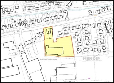
© Crown copyright and database rights 2021 Ordnance Survey 100019309.
Additional Information © Mendip District Council.
Context
Morlands is a former factory site of around 3 ha in total within adopted development limits. The site is subject to a number of constraints which affect the arrangement and type of suitable uses. These include an area of flood risk to the north and a central area of contaminated land. The site lies adjacent to the Glastonbury Sewage Treatment Works and the whole site is subject to odour nuisance. The site is vacant and a historic permission for employment use has not been implemented. Over a number of years, parts of the site have been trespassed by van dwellers resulting in a significant number of lived-in and abandoned vehicles on the site.
Provision of a Traveller Site
This location would not normally be considered appropriate for residential use. However, the Council will seek to bring forward a permanent and regularised site for Travellers within the allocated area identified as Policy GL5. This is justified on the basis of the urgent need for Traveller pitches in Mendip District and specifically around Glastonbury. The Council cannot demonstrate a five-year supply of Traveller sites and LPP1 Policy DP15 identifies a need for around 140 residential pitches over the plan period 2006-2029 -based on the 2013 Gypsy and Traveller accommodation assessment (GTAA). 31 pitches on individual private sites have been provided to 2019 against the shortfall in the GTAA. While the GTAA is to be updated, there remains a shortfall to be addressed and no alternative sites have been identified through this or other plans to date. Occupiers of the Travellers site should meet the definition in national policy.
The extent, location and number of pitches will be identified through a remediation and implementation plan for the site as detailed in this policy. The form of pitch provision and services will need to be addressed to take account of site constraints. The Travellers site will be expected to make a significant contribution to addressing the current need for pitches. Provisionally around 1.3 Ha may be required for the Travellers site (including mitigation areas) with 0.6 Ha in employment uses.
Employment Uses
The remainder of the allocated land is suitable for a range of employment uses. The layout and type of provision should be addressed in the implementation plan. Potential uses will need to take account of land contamination and environmental constraints. Priority will be given to bringing forward a remediated site for Traveller provision and wider use of the site may be needed in the first instance to put in place remediation and mitigation measures.
Remediation and Implementation Plan
The revised extent of the allocated area takes into account known constraints including Flood Zone 2, a sewer easement, buffer to the Mill Stream and drainage ditches adjoining the levels and moors. However, additional assessment of on-site risks from constraints, mitigation options and costs and the nature/phasing of remediation work is required.
A remediation and implementation plan will be developed prior to grant of planning permission for any part of site ST3. The plan should include:
To reflect the urgent need for provision, the remediation and implementation plan should be published within 12 months of adoption of LPP2.
Odour Nuisance
The allocated site is directly adjacent to the Glastonbury Sewage Treatment Works (STW) and is subject to potentially significant levels of odour nuisance. However, the level of nuisance will be balanced against the exceptional need to provide for a travellers site in this Plan and cannot be a considered absolute constraint. It will also need to be taken into account in considering employment uses. Updated odour studies are being undertaken to provide the basis to explore practical ways to minimise odour nuisance (through landscaping, buffer areas and location of the Traveller site). In addition, the implementation plan should specify on-site and off-site mitigation measures to proactively reduce risk of nuisance.
Highways
The main highway access will be from the southern part of site (Beckery) and there is potential for a secondary access from Beckery Old Road. Both access points cross flood zone 2.
A traffic impact assessment will be required to support the implementation plan.
Contaminated Land
Previous studies have identified an area of contaminated land in the north of the allocated site where risks can be mitigated. This will need to be addressed in the implementation plan.
Landscape & Ecology
The site is adjacent to the Glastonbury Wastewater Treatment Works and within 4km of the Somerset Levels and Moors SPA / Ramsar. This will need to be taken into account in the remediation plan and its implementation. This will include managing runoff and drainage from the Travellers site and employment area and the impact of additional phosphates. Updated surveys should be undertaken to cover trees, biodiversity and the presence of invasive species. The implementation plan should also include measures to maintain and enhance the biodiversity of the site.
Phosphates
The features of the Somerset Levels and Moors Ramsar Site are considered unfavourable, or at risk, from the effects of excessive phosphates. The remediation plan and subsequent development proposals will need to take into account the impact of additional phosphate loading of the uses proposed on designated areas. A mitigation solution will need to be agreed to secure a ‘phosphate neutral’ position.
Drainage and Flood Risk
The allocated area is in flood zone 1 (lower risk) and excludes the area of flood zone 2 to the north.
Heritage
Consideration should be given to impact on the setting of the listed Bailys Tannery. The Tannery buildings are vacant and subject to a consented restoration scheme.
Policy GL5: Morlands Development Requirements and Design Principles
Policy GL5: Land at Morlands (HELAA Site GLAS117E)
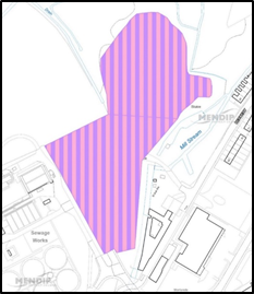
© Crown copyright and database rights 2021 Ordnance Survey 100019309.
Additional Information © Mendip District Council.
10.3.1 The village of Street is the second largest settlement in the district with a population of just under 13,000 people. Despite its village status, it provides a good range of services and facilities similar to the other market towns in Mendip.
10.3.2 The economy of Street was formerly based around shoe making, with the Clarks brand being synonymous with the town. Following a decline in the UK manufacture of shoes in the 1980s, Clarks moved from their original premises in the town to their Houndwood headquarters. They remain a major employer in the town and are an internationally recognised business.
10.3.3 In the 1990s the original Clarks site was regenerated into Clarks Village Factory Outlet Centre. This is a sub-regional shopping destination attracting shoppers from well beyond the district boundaries.
10.3.4 Street is also an important educational centre with Strode College, Crispin School and Millfield Senior School all located within the town. The education authority have advised financial contributions may be sought to ensure delivery of additional primary places in the medium to long term.
10.3.5 The town has a strong relationship with nearby Glastonbury for work and access to shops and services. It also has a close relationship with the village of Walton which lies directly to the west of Street.
10.3.6 A Neighbourhood Plan is being prepared for Street and the Neighbourhood Area has been designated. Work on the plan in ongoing.
10.3.7 Street is identified in LPP1 as a principal settlement. LPP1 Core Policy 8: Street Parish Strategy indicates 1,300 new homes are to be delivered over the plan period in the town. Compared against completions since 2006 and current commitments of 868 dwellings, there is a shortfall of 432 dwellings against the residual plan requirement. The strategic site allocated to the west of Brooks Road will provide around 400 dwellings.
10.3.8 Street is within an area where wastewater and other water flows may have a ‘likely significant effect’ on the Somerset Levels and Moors RAMSAR which is in an ‘unfavourable condition’. Development allocations should assess additional phosphate loading on the catchment of the designated area and a mitigation solution agreed to secure a ‘phosphate neutral’ position.
10.3.9 Since adoption of LPP1, there has been limited progress to develop a masterplan for the strategic site. With development on the Houndwood site nearing completion, further allocations are warranted to support supply over the plan period.
10.3.10 Housing allocations are proposed at:
10.3.11 Core Policy 8 (Street Parish Strategy) identifies a broad area for 400-500 dwellings to come forward to the west of Street (in the Parish of Walton). A Future Growth Area (FGA) was identified on land to the south of the site in LPP1.
10.3.12 The Habitat Regulations Assessment for LPP2 highlights that the development potential of the FGA, including the southern extent of the land allocated in LPP1, remain subject to further ecological assessment. Potentially, alternative development options in the wider location will need to be explored including north and west of the strategic site.
10.3.13 Policy ST3 identifies a Main Development Area (MDA) to provide a minimum of 400 dwellings. This includes the majority of the land previously allocated as the FGA in LPP1 and additional land to the north and west. This provides additional access options to deliver the strategic site from Brooks Road or the A39 and greater certainty in deliverability. It also provides flexibility to address the ‘strategic-scale’ open space requirement of LPP1 and opportunities to provide mitigation for phosphates impacts. The MDA involves a revision to the ‘Green Gap’ that was previously identified. The revised Green Gap still provides a visual separation between Street and Walton.
Employment
10.3.14 A specific employment allocation has been made on land in Walton Parish, which was previously identified as a Future Employment Growth Area in the LPP1. The potential of land to the north of the Westway (opposite Clarks) will also be explored; this continues to be highlighted as a Future Employment Growth Area.
10.3.15 There are no amendments proposed to reflect committed development. Limits around sites allocated for development have been amended on the Policies Map. The appropriate development limit adjacent to the allocated strategic site / designated FGA will be determined through wider masterplanning.
Context
An 11.6ha site comprising three agricultural fields on the south eastern edge of Street. The site adjoins existing housing to the north. The southern and western fringes lie adjacent to open agricultural land. A public footpath crosses the site. The site currently has an open rural character and is distant from town facilities. Access is anticipated from Somerton Road. The site promoter suggests that the development could include affordable housing, custom build housing, public open space, allotments and community orchards.
Landscape & Ecology
The site contains a number of hedgerows and trees. There is a white willow tree which is protected on the northern boundary. Lesser horseshoe, brown long-eared, common and soprano pipistrelle bats are potentially present at low density. Surveys and biodiversity measures should consider the value of the site for butterflies (including brown hairstreak) and for owls.
The hedgerows within and bordering the site may support hazel dormice, a European protected species, which have been recorded on Walton Hill. Surveys will be needed and further assessment may be required to demonstrate ‘Favourable Conservation Status’, if present. However, this site is more distant from Walton Hill than the strategic site west of street (Policy ST3). Hedgerows should be protected by additional planting and a buffer of meadow grassland, and not incorporated as residential garden boundaries.
Heritage
Development should respect the local context and be sensitive to the location. The Street Conservation Area lies to the west of the site.
Flooding
A stream runs along the northern boundary of the site which is flood zone 3. There is an area of low-medium risk for surface water flooding located through the middle section of the site. There are high risk areas for surface water flooding in the north-east corner and in the south-east of the site.
Policy ST1: Development Requirements and Design Principles
Policy ST1: Land West of Somerton Road (HELAA Site STR003)
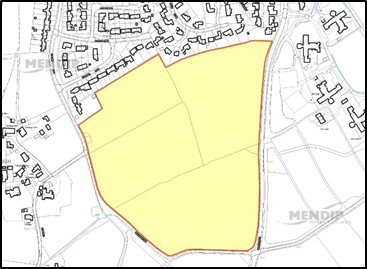
© Crown copyright and database rights 2021 Ordnance Survey 100019309.
Additional Information © Mendip District Council.
Context
The site is 0.94ha and is open land with a frontage to Cemetery Lane and a smaller plot fronting Portland Road. It is adjacent to development limits with open land to the north and woodland cover at the eastern end of the site where it adjoins the cemetery. It fits well within the existing built form. Although much of Street Village’s facilities are located across the A39, there are good pedestrian links and this site could link to the adjacent recreation space. Access could be achieved from Portland Road/Cemetery Lane.
Landscape & Ecology
The site fits well within the built form of Street and is not considered to have a significant landscape impact.
The Habitat Regulations Assessment notes the proximity of this site to the Somerset Levels and Moors SPA/Ramsar. This can be mitigated through provision of sufficient accessible natural greenspace located in the Strategic Site and Future Growth Area. There is a designated local wildlife site at Bullmead Ditch which is 230m east of the site.
The site is a semi-improved grassland field with internal hedgerows. Lesser horseshoe, brown long-eared and soprano pipistrelle bats are potentially present at low density. Brown hairstreak butterflies, which is a S41 species, may be present in hedgerows and along the lane. Barn owls, a Schedule 1 and s41 bird, may hunt over the site.
Heritage
While the site does not lie within a Conservation Area or close to any designated heritage assets, any development should respect the local context and be sensitive to the location.
Policy ST2: Development Requirements and Design Principles
Policy ST2: Land adjacent to Street Cemetery (HELAA Site STR137)
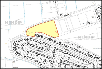
© Crown copyright and database rights 2021 Ordnance Survey 100019309.
Additional Information © Mendip District Council.
Context
Land to the west of Brooks Road is identified as a strategic housing allocation by LPP1 Policy CP8b. The adopted allocation and additional land (formerly Future Growth Area) is allocated for housing and other uses as specified in LPP1 Policy ST3. A Future Growth Area (FGA) is identified to the south of the Main Development Area.
Land within the Main Development Area
The 24ha allocated as the Main Development Area is expected to provide a minimum of 400 dwellings, a link road from the A39, recreation space and land for a primary school. Existing woodland to the north and west of Brookfield Way should form part of a ‘green corridor’ which links to the FGA. Development of land around the A39 should reflect its importance as a gateway into Street.
Land within the Future Growth Area (FGA)
Development in the FGA (24ha) will need to reflect wildlife constraints and provide green links to the Walton and Ivythorn Hill SSSI 700m to the south. The FGA will be expected to include buffer areas to sensitive habitats and provision of strategic accessible greenspace/green recreation uses. Additional small-scale housing, compatible with the environmental constraints, may also be appropriate.
Masterplanning
Masterplanning for both the Main Development Area and the FGA should be undertaken prior to the granting of planning permission for any part of site ST3. The masterplan should include:
A masterplan and subsequent development proposals should be supported by technical studies covering highways and traffic impact, sustainable transport links and demonstrate how the following issues will be addressed: ecology, drainage, transport and landscape.
The Council will seek the involvement of appropriate professionals and all stakeholders, together with early agreement of a programme for delivery.
Highways
The principal access to the adopted allocation is expected from the A39. There are a number of access options from Brooks Road which may be suitable to accommodate initial phases of development. An extension of the link road through the FGA to create a ‘loop’ to Brooks Road should be tested through the masterplan and supporting technical studies.
Landscape
Ivythorn Hill Special Landscape Feature is around 250m to the south of the site. Views from Walton Hill will also need to be considered in the masterplan.
Ecology
The woodlands and hedgerow in the FGA are known to support a population of hazel dormice, a European protected species. Masterplanning of the area is required to avoid impacts through loss and fragmentation of dormice habitat. Any proposal will need to demonstrate the maintenance of Favourable Conservation Status of the population.
The woodland within the proposed allocation site is a ‘stepping stone’ in the ecological network. Ecological advice recommends that new and retained hedgerows should be protected by additional planting and a buffer of meadow grassland. Hedgerows should not be incorporated as residential garden boundaries.
Common and soprano pipistrelle and noctule bats have been recorded in the locale. On-site and adjacent woodland should be surveyed. Appropriate and sufficient replacement habitat for bats is likely to be required within the masterplan. Two s41 priority butterfly species may also present - the brown hairstreak and wall - and surveys will need to cover this group.
Accessible Natural Greenspace
The strategic site and FGA are identified as a location to provide strategic accessible greenspace to mitigate wider development impacts on the Somerset Levels and Moors SPA/Ramsar site.
Heritage
While the site does not lie within a Conservation Area or close to any designated heritage assets, any development should respect the local context and be sensitive to the location.
Contamination
There is a small landfill site just east of Eastmead Cottages.
Policy ST3: Development Requirements and Design Principles
Land is identified as a Main Development Area and Future Growth Area (FGA) and includes the strategic housing allocation in LPP1 Policy CP8b. The release of the land will be dependent on a comprehensive masterplan.
Policy ST3: Revised Local Plan Allocation
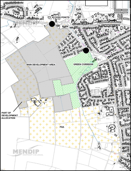
© Crown copyright and database rights 2021 Ordnance Survey 100019309.
Additional Information © Mendip District Council.
Context
The site is 4.32ha of open land off Gravenchon Way, between Street Business Park and Quarry Batch Farm. The land was identified as a Future Growth Area for employment in LPP1 and is now allocated for that purpose.
Masterplanning
A masterplan should be developed for the allocation which should seek to maximise delivery of B1, B2 and B8 uses, landscaping and highways infrastructure. Development of the site should seek to retain a visual break between Street and Walton from the Westway frontage.
Landscape & Ecology
The site is currently a green gap between Street and Walton and this is a notable feature of the approach to Street from the west. However, the FGA does not abut Westway and there is a strip of land outside the FGA between it and the road. This strip has been left outside the FGA to maintain the sense of a green gap between Quarry Batch Farm and the business park. Part of this area is currently used as a skate park. It is now proposed to include the strip of land abutting Westway in the allocation in order to secure its future use as a green area within any scheme.
There is a designated local wildlife site - Bullmead Ditch - which crosses the western part of the site. Bullmead Ditch is a tufa stream with rare invertebrates. Lighting will need to be strictly controlled.
The site is improved pasture with over-managed hedgerows and immature trees/scrub along the A361 on the southern boundary. Brown hairstreak butterflies, a s41 priority species, is potentially present in the hedgerows.
Soprano pipistrelle bats are potentially present at low density over Bullmead Ditch, and the Great Green Bush-cricket, a s41 priority species, is probably present.
Phosphates
The potential impact of phosphates on designated sites from the allocated uses should be taken into account in mitigating the environmental impact of the development. Mixed use or residential proposals should assess additional phosphate loading on the designated catchment and a mitigation solution agreed to secure a ‘phosphate neutral’ position.
Heritage
While the site does not lie within a Conservation Area or close to any designated heritage assets, any development should respect the local context and be sensitive to the location.
Surface Water
There are areas of low, medium and high risk from surface water flooding around the Bullmead Ditch to the west of the site and along the eastern boundary.
Highways
The need and feasibility of a second highways access from Westway connecting to Gravenchon Way should be explored as part of a comprehensive plan for the allocation.
Policy ST4: Development Requirements and Design Principles
Policy ST4: Land south of Street Business Park (HELAA Site STR138E)
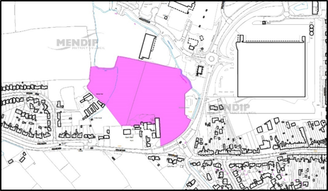
© Crown copyright and database rights 2021 Ordnance Survey 100019309.
Additional Information © Mendip District Council.
10.4.1 Shepton Mallet is located in the heart of Mendip district, with the Mendip Hills lying to the north and the River Sheppey running through the town. It lies on the A37 primary route with good links to the other Mendip towns as well as Bristol, Bath and Yeovil.
10.4.2 The town contains a fine parish church and a considerable number of historic and interesting sites. Shepton Mallet Prison, for example, was England's oldest prison still in use until its closure in March 2013.
10.4.3 Shepton Mallet is the second smallest town with a population of just over 10,000 people but has the smallest town centre which, although home to a number of successful independent businesses and retailers, would benefit from improvements to its physical appearance to encourage investment. A masterplan is in preparation to support public realm improvements, connectivity and green infrastructure in the town centre.
Infrastructure
10.4.4 The education authority have advised financial contributions will be sought on major development to ensure delivery of additional primary places in the medium term. A primary school site will be provided in the Cannards Grave allocation.
10.4.5 A Neighbourhood Plan is being prepared for Shepton Mallet and the Neighbourhood Area has been designated.
Site Allocations
10.4.6 Shepton Mallet was identified in LPP1 as a principal settlement and Core Policy 9 indicates 1,300 new homes are to be delivered over the plan period in the town.
10.4.7 727 homes were completed to March 2019 and total identified supply is 786 dwellings. The supply figure includes allocated land at Cannards Grave Road which has been subject to a detailed masterplanning exercise. The site is expected to deliver in the region of 600 homes. In addition to this site, consent has been granted for the refurbishment and redevelopment of the former Shepton Mallet Prison for 134 dwellings. Given that these schemes will deliver a substantial uplift over the LPP1 requirement, no additional sites are allocated in the town.
10.4.8 Additional windfall sites are expected to come forward within the development limits of the town. There are also a number of potential redevelopment opportunities on brownfield land around the town centre.
10.4.9 Land is highlighted by LPP1 as a Future Growth Area east of Compton Road. This notation will be deleted from the policies map as masterplanning has now clarified the extent of land needed to deliver the strategic site. As development will require a comprehensive approach – particularly infrastructure and access which would be better re-assessed in the context of the future Plan Review.
10.4.10 Shepton Mallet is within an area where wastewater and other water flows may have a ‘likely significant effect’ on the Somerset Levels and Moors RAMSAR which is in an ‘unfavourable condition’. Development allocations should assess additional phosphate loading on the catchment of the designated area and a mitigation solution agreed to secure a ‘phosphate neutral’ position.
10.4.11 There are a number of major employment sites within the town. A site is allocated on promoted land off Fosse Lane for employment use. South of Shepton Mallet, the Bath & West Showground includes specific provision of a further 10 hectares of employment land.
10.4.12 No amendments are proposed to the development limits.
Context
This is an extensive greenfield area adjacent to Fosse Lane with access onto to the A37 and A361. It lies just south of Shepton Mallet and is adjacent to the development limit.
Landscape & Ecology
The site is identified as improved grassland with no significant biodiversity issues. While the site is allocated for employment uses, the potential impact of phosphates should be considered in any assessment and mitigation of environmental impacts.
Heritage
The allocated land lies adjacent to a designated Scheduled Monument; this contains an area of the Romano-British linear village at Fosse Lane. The whole site is in an Area of High Archaeological Potential and an Area of Archaeological Interest. Archaeological surveys indicate a developable scheme is achievable without impact on significant archaeology.
Prior to submission of any detailed development scheme, the Council will require a detailed assessment of the potential impact on archaeological assets to be agreed with English Heritage.
Highways
Access is proposed from the A361 from Frampton Road. The route will need to take into account archaeological constraints as it will cross the scheduled area.
Policy SM1: Development Requirements and Design Principles
Policy SM1: Land off Fosse Lane (HELAA Site SHEP112E)
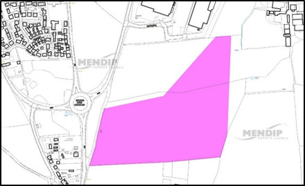
© Crown copyright and database rights 2021 Ordnance Survey 100019309.
Additional Information © Mendip District Council.
10.5.1 Wells is widely known as the smallest city in England, with a population of 11,000 people. The city is an important cultural and historic centre focused on Wells Cathedral and the Bishop's Palace. Wells is also a significant centre for local services and shopping and has a strong independent retail sector.
10.5.2 Wells is a key economic centre in Mendip and has a broad base of employment with a workforce with skill levels above the national average. There are a range of specialist professional practices, a public school and a range of health sector services, as well as a vibrant small business sector and a growing tourist economy.
10.5.3 The city has an older age-profile than other towns in Mendip. Long term in-migration has put pressure on housing affordability.
10.5.4 The heritage, landscape and compact character of Wells constrain the locations for new development in the city.
10.5.5 Both Wells and the Parish of St Cuthbert-Out are designated as Neighbourhood Plan Areas. No formal consultation has yet been undertaken on these plans.
10.5.6 The education authority have advised financial contributions will be sought on major development to ensure delivery of additional primary places in the medium term. A primary school site is likely to come forward off Wookey Hole Road.
10.5.7 Wells is within an area where wastewater and other water flows may have a ‘likely significant effect’ on the Somerset Levels and Moors RAMSAR which is in an ‘unfavourable condition’. Development allocations should assess additional phosphate loading on the catchment of the designated area and a mitigation solution agreed to secure a ‘phosphate neutral’ position.
10.5.8 LPP1 sets out that Wells should deliver a minimum of 1,450 homes. Existing commitments and dwellings built to date totals 1,423 leaving a residual figure of 27 dwellings (see Table 3). Sites are allocated to meet the residual requirement and to maintain housing supply. Land south of Elm Close supports supply in the medium term.
10.5.9 There are a number of business parks in the city with the majority of space at Cathedral Park now taken up. The land allocated at Dulcote Quarry has now been taken up by a food manufacturer. The potential of land south of the St Cuthbert’s Mill in St Cuthbert Out Parish will be explored.
10.5.10 The following sites are allocated for development under the following polices:
10.5.11 Community facilities are proposed at:
WL3 - New Rugby Club Site at Haybridge (linked to WL4)
10.5.12 Development limits were amended to include strategic sites in LPP1. A change to the development limit is proposed to reflect the developable area associated with the permission on the Future Growth Area identified in LPP1. The adopted green gap designation will be extended to ensure the separation of built development from Haybridge. Limits around sites allocated for development have been revised.
Context
The site is made up of three fields on the south-west side of the city which slope to the south. There are some mature hedgerow boundaries along and within the site. The site abuts existing residential development on its eastern edge.
This site was previously excluded given its proximity to the Wells Sewage Treatment Plant and location within a buffer zone where development should be restricted. The promoter has provided updated modelling of the area affected by odour from the plant in consultation with Wessex Water. It indicates that around 4.5ha would be suitable for residential use with the northern field (adjacent to Burcott Road) and southerly field (opposite Stilling Close) having the most potential.
Landscape
The site is not prominent in the wider landscape, although there are views from the land towards Ham Hill and Ben Knowle Hill.
Ecology
The site is adjacent to Wells Sewage Treatment Works Wildlife site. Surveys will be needed to assess the potential for disturbance on wintering and protected birds as this may have an effect on the Somerset Levels and Moors SPA/Ramsar site. Development will involve potential loss of foraging habitat for bats. Provisionally a masterplan should include a minimum of 1.2 ha of accessible replacement habitat.
Highways
There are a number of points of access including Burcott Road. Access will need to meet highways standards on width and visibility. Provision of footways and cycle connections will also need to be considered. Burcott Road would need to be upgraded to standard acceptable to the Highway Authority.
Heritage
While the site does not lie within a Conservation Area or close to any designated heritage assets, any development should respect the local context and be sensitive to the location.
Odour Nuisance
Wessex Water have advised that updated modelling to the latest industry guidelines will be required to determine the developable areas and capacity of the site.
Flooding
There is an area at low to medium risk of flooding from surface water on the northern part of the site.
Policy WL1: Development Requirements and Design Principles
Policy WL1: Land off Bubwith Walk (HELAA Site WELLS044)
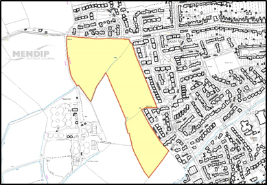
© Crown copyright and database rights 2021 Ordnance Survey 100019309.
Additional Information © Mendip District Council.
Context
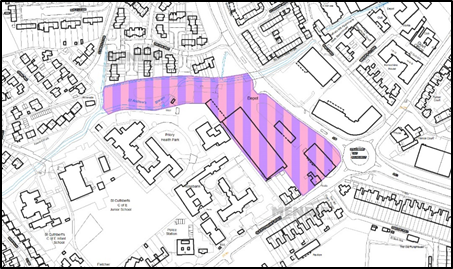
This is a large edge of centre site which is bounded by Glastonbury Road and Strawberry Way. Part of the site is used as a country store with an extensive depot to the rear (mix of shed/storage buildings). The northern portion of the site includes a ‘tongue’ of land following St Andrews stream. This was former railway land which is partly overgrown together with open storage. The extent of development would need to reflect a flood risk assessment on the site.
Landscape & Ecology
A row of protected trees in the north-west corner of site, north of St Andrews stream, would need to be taken into account and protected in any scheme.
The site is brownfield comprised of hardstanding and buildings and is of low biodiversity value.
Heritage
There are adjacent listed buildings to the west - Priory Hospital and the Sherston Pub which is opposite on Strawberry Way roundabout. The site is adjacent to the Conservation Area boundary.
Flood Risk
Parts of the site are within flood zones 2 and 3 and any design will need to take flood risk into account.
Contamination
There may be localised contamination on the site which would require remediation.
Policy WL4: Development Requirements and Design Principles
Policy WL4: Tincknells Depot (HELAA Site WELLS116M)
© Crown copyright and database rights 2021 Ordnance Survey 100019309.
Additional Information © Mendip District Council.
Context
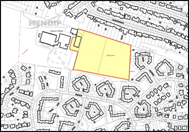
Redevelopment of the club and sports ground for housing is linked to the relocation of Wells Rugby Ground to a new facility at Haybridge in accordance with LPP2 Policy WL3. The site consists of sports pitches and a club building surrounded by residential development on three sides. The club building is located next to Wells Leisure Centre. This is a greenfield site within the urban area which is accessible to the town centre and local facilities.
The land is suitable for housing but is subject to the re-provision of the club and pitches. A traffic impact assessment will be needed and may constrain the overall capacity of the site as it is accessed through surrounding residential areas.
Landscape & Ecology
The existing ground is enclosed by residential development and an adjacent car park/open space around Wells Leisure Centre. The site is amenity grassland with some hedgerow likely to be of low biodiversity value. There would be opportunities to improve the biodiversity of the site through strengthening hedgerows and landscaping. The removal of floodlighting may also be beneficial to local/foraging bat populations.
Heritage
While the site does not lie within a Conservation Area or close to any designated heritage assets, any development should respect the local context and be sensitive to the location.
Flood Risk
The site is in flood zone 1 but there is a localised surface water flood risk along the southern boundary of the site and an area of high risk in the south-west corner of the sports ground.
Highways
The site can only be accessed through the Charter Way estate which links to the A371. A traffic assessment will be required which takes into account the cumulative impact of committed development to the west.
Policy WL2: Development Requirements and Design Principles
Policy WL2: Land at Wells Rugby Club (HELAA site WELLS094)
© Crown copyright and database rights 2021 Ordnance Survey 100019309.
Additional Information © Mendip District Council.
Context
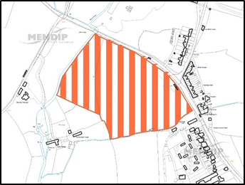
Land is allocated to replace and enhance the existing club and ground and is linked to LPP2 Policy WL2. Other sports facilities may also be provided on this site and may also include a relocation of the Tennis Club.
The preferred site is in open countryside and careful design will be needed to minimise the impact on landscape and surrounding countryside. This is a greenfield site in open countryside west of the small settlement of Haybridge. A traffic impact assessment will be needed to ensure there is capacity for road access. Footpath and cycle access is absent and will need to be addressed in any scheme.
Landscape
The site will be largely playing pitches, which are a green use, but there are likely to be some buildings and hard surfaced areas. The development may therefore have some visual impact on this approach to Wells. There may also be a potential impact on views towards Ben Knowle Hill.
Ecology
Greater and lesser horseshoe bats are likely to be present. Other bats which may potentially be present at low densities along the river corridor include Daubenton’s, Serotine and the rare Barbastelle. The site is within Band B of the North Somerset and Mendip Bats SAC. Currently the site is improved grassland with over managed hedgerows except for the river corridor. Proposals should include 1 Ha of accessible replacement habitat and provide a wildlife buffer along the River Axe corridor. Proposals should also demonstrate lighting would not affect bats.
The site is adjacent to the River Axe wildlife corridor and Local Wildlife Site. Brown Hairstreak and Wall Butterflies, both of which are s41 priority species, may be present in hedgerows.
Heritage
While the site does not lie within a Conservation Area or close to any designated heritage assets, any development should respect the local context and be sensitive to the location.
Highways
Further assessment of capacity may be required. Access by foot and cycle is currently poor.
Policy WL3: Development Requirements and Design Principles
Policy WL3: New Rugby Club Site at Haybridge
© Crown copyright and database rights 2021 Ordnance Survey 100019309.
Additional Information © Mendip District Council.
Context
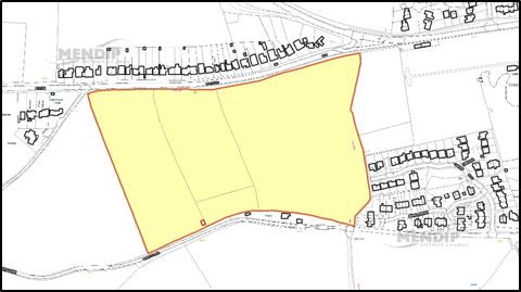
The site comprises three fields of open grassland bounded by mature hedgerows. The eastern boundary of the site adjoins land reserved to extend Wells Cemetery. Elm Close is on a ridge and the fields slope from north to south.
The site is on the edge of Wells and not as accessible as other sites to town centre facilities. Development would represent an extension into the countryside although there are opportunities to provide some community gain through affordable housing and provision of land to extend the city cemetery.
Release and Timing of Development
More than 1000 dwellings are committed to come forward in the next 10 years (2017-2027) located to the west and southwest of Wells. Given the level of significant short time supply and its focus in one location on the edge of the City, early development of this site is not considered necessary in the short term. The site is therefore identified for release after 2024-5. The later release of the site in the Plan period would also provide an opportunity for community uses to be incorporated into masterplanning of the site. The release of the site before 2024-5 should only be considered if necessary to make up a shortfall in delivery from allocated and committed sites in Wells.
Cemetery Extension
The site should provide around 1 ha of land to enable an extension to the Wells Cemetery. This should adjoin the existing site and be located on the ridgeline. The lower parts of the allocated site are not suitable.
Landscape
Previous landscape studies have highlighted the ridgeline as a feature in the wider setting of Wells and the contribution of this general location as a backdrop to Wells. The land to the south of the site is undeveloped. There is potential for impact on views of the Special Landscape Feature at Ben Knowle Hill.
Ecology
The site falls within the Consultation Zone of the North Somerset and Mendip Bats SAC (Band C) and both Greater and lesser horseshoe bats are present in the locality. Provisionally a masterplan should include 0.93 ha of replacement habitat. Any proposals should also seek to minimise the loss and/or fragmentation of internal hedgerows. Brown hairstreak butterflies, a s41 priority species, may be present in the hedgerows.
Heritage
While the site does not lie within a Conservation Area or close to any designated heritage assets, any development should respect the local context and be sensitive to the location.
Odour Nuisance
There is a potential for odour nuisance from the Wells Sewage Treatment Works (located 200m from the southern boundary of the site).
Policy WL5: Development Requirements and Design Principles
The site is allocated for a minimum of 100 dwellings to be developed after 2024-5. Earlier release of the site will need to demonstrate a shortfall in delivery from committed and allocated sites in Wells.
Policy WL5: Land off Elm Close (HELAA Site WELLS084)
© Crown copyright and database rights 2021 Ordnance Survey 100019309.
Additional Information © Mendip District Council.
10.6.1 The market towns of Midsomer Norton and Radstock immediately adjoin the northern boundary of Mendip District and fall within Bath and North East Somerset District. They have functional relationships with some villages in the wider rural catchment within the north of the district.
10.6.2 LPP1 Core Policy 2 identified an additional 505 dwellings as part of the adopted local plan requirement which was not allocated to a specific settlement. The 505 dwellings result from rolling forward the plan period to 2029 and the Review of Housing Requirements (2013) considered in the LPP1 examination. LPP1 Paragraph 4.21 explains that allocations should be in sustainable locations in accordance with the overall spatial strategy and may include land in the north/north-east of the district, primarily on land adjacent to the towns of Midsomer Norton and Radstock. LPP1 Paragraph 4.7 specifically identifies a need to consider allocations in Local Plan Part II in this part of the district to meet Mendip’s development needs.
10.6.3 Following consideration of allocated housing allocations in line with the spatial strategy at the Local Plan examination and wider plan objectives, sites to provide 505 dwellings have been identified as a strategic requirement and were addressed through Main Modifications to this plan. LPP1 Paragraph 4.7 notes the need for consultation with Bath & NE Somerset (BaNES) and local communities which was undertaken through the LPP2 examination process and particularly the Main Modifications consultation.
10.6.4 The determination of planning applications on these sites will require joint working with BaNES in the assessment of proposals and impacts on infrastructure and planning gain arrangements. The education authority estimates that the allocations will require around 130 primary school places.
10.6.5 The Bath & North East Somerset Placemaking Plan sets out its strategy for the two towns. This strategy is to make provision for the development of the economic and community facilities needed to increase self-reliance and economic revitalisation.
10.6.6 A Neighbourhood Area was designated for Midsomer Norton in November 2013 and a Neighbourhood Plan is in production. Radstock Town Council have also shown interest in developing a Neighbourhood Plan but as yet no formal application for a Neighbourhood Area has been made. A Neighbourhood plan was “made” for Westfield Parish in November 2018.
10.6.7 Circa 1,000 dwellings have been built in Midsomer Norton & Radstock in the period 2011-2020. 417 more homes are committed within B&NES to be delivered by 2029,
and a further 455 dwellings are allocated by this Local Plan at Midsomer Norton in Mendip District. Development proposals must assess and mitigate the potential cumulative transport impacts which may arise from committed development, both within Mendip District and Bath and North East Somerset, through undertaking a cross-boundary transport impact assessment.
10.6.8 The cross-boundary transport impact assessment must take account of the committed and allocated development schemes in Midsomer Norton and Westfield, analyse traffic impacts on both links and junctions, and robustly assess the potential traffic effects of re-routing as a result of any additional congestion. Development proposals must identify mitigation to address the cumulative impacts of committed and allocated development and establish the proportionate impact of the application scheme to enable appropriate mitigation to be agreed with the Highways Authorities. Development proposals will need to assess their impact on the availability of town centre parking, as this remains of key importance to enabling access to the town centre for much of the rural hinterland, thus supporting access to facilities and the vitality of the town centre itself.
10.6.9 Detailed mitigation proposals will need to be identified and evidenced through the planning application process. In line with Climate Emergency declarations by both BaNES District Council and Mendip District Council, mitigation of impacts will need to be targeted at providing sustainable alternatives to car usage, with increases in highway capacity required only when opportunities to achieve mode shift to sustainable travel have been explored. Highway schemes will also need to address road safety and provide facilities for pedestrians and cyclists.
10.6.10 Each development should appropriately connect with the walking and cycling network, proactively support the delivery of the West of England Local Walking and Cycling Infrastructure Plan (LCWIP), including routes W05 and C05, and address local gaps in provision along routes likely to be used by future occupiers. Improvements to the pedestrian environment and public realm in Midsomer Norton town centre will be supported as making a positive contribution towards mitigation requirements. Public transport service enhancements will be important to address the risk of car-dependent development, potentially including proportionate measures to improve the attractiveness of the Odd Down Park and Ride site for trips into Bath.
10.6.11 The following sites are allocated for development to meet housing needs in Mendip under the following polices:
10.6.12 A development limit will be shown around the allocated sites on the policies map.
Context
The site is 12.1 ha and consists of a large single field in open countryside on the fringe of Midsomer Norton. The field lies between the A367 Fosseway to the east and the B3355 Silver Street to the west. There is some limited built development to the south of the site including Norton Hall Farm on Silver Street and the White Post Inn on Fosseway. The northern boundary of the site is adjacent to a new housing development in the BaNES LPA area. A safeguarded recreation site under LPP1 Policy DP16 (Midsomer Norton Rugby Club) lies to the west on Silver Street.
Ecology
There is a well-established hedge line on the northern and eastern boundary of the site with mature trees. The site lies outside the Bat SAC consultation area but up to date surveys should be undertaken and there may be a need for bat mitigation. Development proposals should avoid loss of hedgerows and trees and strengthen their value as wildlife habitat. Biodiversity measures should deliver at least 10% net gain.
Landscape
The site lies on the edge of the built-up area. Development will have a degree of impact upon local landscape character and long-distance views. Proposals should take account of the wider landscape context and adjacent built development.
Heritage
The site does not lie within a Conservation Area or close to designated heritage assets. Advice from Somerset archaeology on a previous planning application noted presence of archaeological features with potential for additional investigation.
Highways
There are potential points of access onto Fosseway (A367) and to Silver Street (B3355). Parts of Silver Street are being upgraded, including with improved pedestrian/cycle infrastructure. Access arrangements should be independent of adjacent development to the north of the site. Particular regard should be given to access by walking and cycling and connectivity of the site to local facilities. A cross-boundary transport impact assessment (agreed with both Mendip and BaNES) and travel plan for the development will be required. This should consider the cumulative impacts on the highway network (including on the availability of town centre parking) of committed and allocated development in Midsomer Norton, including MN3. Mitigation proposals will need to be
targeted and primarily seek to reduce car usage, including through providing local walking
and cycling improvements, and measures to improve the attractiveness and connectivity of bus services. The transport impact assessment will need to determine the need for, and form of, highway capacity measures to mitigate the impact of the proposed development. Proportionate contributions will be sought towards mitigation demonstrated to be required to address severe cumulative impacts of committed development proposals.
Education
The site falls within the Chilcompton primary school catchment which is at capacity. However, the site is within statutory walking distance of St Benedict’s Catholic Primary School (in Mendip District) which is located to the north east of the site between Fosseway and Charlton Lane. This school is also near capacity but takes a high proportion of pupils from BaNES (80%). A new three form entry BaNES school (Norton Hill Primary) is being built just to the west of the site, within the B&NES boundary, and will be accepting new pupils from September 2020. This new school will also be within walking distance of this site. Joint working will be required between the councils and education authorities to accommodate the pupil numbers arising from the proposed development at MN1 and MN3. Development contributions may be needed to enhance local capacity or for travel to schools outside statutory walking distance.
Flooding
The site lies within flood zone 1. There is a limited area of surface water flooding (low risk) on the NE boundary of the site. A flood risk assessment will be required to demonstrate surface water runoff can be managed through use of sustainable drainage (SuDs).
Policy MN1: Development Requirements and Design Principles
Policy MN1: Land at White Post (HELAA Site NRAD001M)
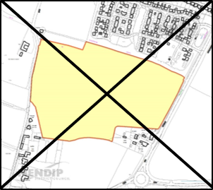
© Crown copyright and database rights 2021 Ordnance Survey 100019309.
Additional Information © Mendip District Council.
Context
The site is 2.1ha and lies on the western edge of Midsomer Norton to the rear of residential properties at Orchard Vale and the Woodside Estate to the south. It forms part of the established countryside edge of the town, is enclosed by protected woodland to the north and south and sits within the Wellow Brook Valley. The site is accessed through a narrow track from Underhill Lane although access to the land may be sought from Orchard Vale. The Woodside estate to the south of the site includes four storey buildings and there may therefore be some overlooking issues across the site.
Landscape & Ecology
The surrounding broadleaf woodland is locally distinctive in the immediate area and Underhill Wood is a designated Local Wildlife Site. The woods have value both as a local habitat (for flora) and a wider value along the valley (as a stepping stone in the wider ecological network). The site is likely to require a 5-15m wide buffer between development and woodland on the western and southern boundaries. The site lies outside the Bat SAC consultation area. The woods are also potentially used by lesser horseshoe bats and potentially for roosting Daubenton’s bats given the proximity of the river to the north Mitigation measures may be required to offset any potential impact to this habitat and should deliver at least a 10% biodiversity net gain.
Heritage
While the site does not lie within a Conservation Area or close to any designated heritage assets, any development should respect the local context and be sensitive to the location.
Highways
The existing access to the site from Underhill Lane is unlikely to be suitable and a more practical access would be via Orchard Vale. A suitable access will need to meet highways standards, including on width and visibility. Enhancement of connections to the town by all modes will also need to be considered. A Transport Impact Assessment will be required to assess impacts on the Local Road Network and mitigation measures may need to be agreed with BaNES.
Flood Risk
The site lies within flood zone 1. A flood risk assessment will be required to demonstrate surface water runoff can be managed through use of sustainable drainage (SuDs) and should take account flood risk associated with a watercourse which runs along the eastern boundary.
Education
The site is in the Chewton Mendip school catchment. There is short term capacity at this school although there are closer schools in BaNES. The impact on local school places in Midsomer Norton will require joint assessment and agreement of solutions with BaNES. Financial contributions may be required to mitigate the impact on local schools or funding for school transport.
Policy MN2: Development Requirements and Design Principles
Policy MN2: Land at Underhill Lane (HELAA Site NRAD003)
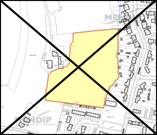
© Crown copyright and database rights 2021 Ordnance Survey 100019309.
Additional Information © Mendip District Council.
Context
The site is 6.5ha and is part of the countryside edge of Westfield, which forms part of the urban area of Norton Radstock. The northern boundary of the site is adjacent to the built up area of Westfield. The western boundary lies on the opposite side of the A367 Fosseway to a new housing development within B&NES.
Landscape
The site lies on the edge of the built-up area. Development will have a degree of impact upon local landscape character and long-distance views. Proposals should take account of the wider landscape context and adjacent built development.
Ecology
There is a well-established hedge line on the western boundary of the site. The site lies on the periphery of the Mells Valley SAC Bat Consultation Area (Band C). Development should incorporate specific requirements for bat mitigation, minimise loss of hedgerows and trees and strengthen the value of the site overall and its existing features as wildlife habitat. Biodiversity measures should deliver at least a 10% net gain.
Heritage
While the site does not lie within a Conservation Area or close to any designated heritage assets, any development should respect the local context and be sensitive to the location.
Highways and Connectivity
The principal access will be from A367 (Fosseway). A cross-boundary traffic impact assessment (both Mendip and B&NES) and travel plan for the development will be required. This should consider the cumulative impacts on the highway network (including on the availability of town centre parking) of committed and allocated development in Midsomer Norton, including MN1. Mitigation proposals will need to be targeted and primarily seek to reduce car usage, including through providing local walking & cycling improvements, and measures to improve the attractiveness and connectivity of bus services. The transport impact assessment will need to determine the need for, and form of, highway capacity measures to mitigate the impact of the proposed development. Proportionate contributions will be sought towards mitigation demonstrated to be required to address severe cumulative impacts of committed development proposals.
Education
This site falls within the Kilmersdon primary school catchment which is at capacity. However, the site is within 300m of St Benedict’s Catholic Primary School (in Mendip District) which is located to the north. This school is also near capacity but takes a high proportion of pupils from BaNES (80%). A new three form entry BaNES school (Norton Hill Primary) is under construction within walking distance of the site and will be accepting new pupils from September 2020. Joint working will be required between the councils and education authorities to accommodate the pupil numbers arising from this allocation Development contributions may be needed to enhance local capacity or for travel to schools outside statutory walking distance.
Flood Risk
The site lies within flood zone 1. A flood risk assessment will be required to demonstrate surface water runoff can be managed through use of sustainable drainage (SuDs).
Policy MN3: Development Requirements and Design Principles
Policy MN3: Land east of A367 (HELAA Site NRAD005)
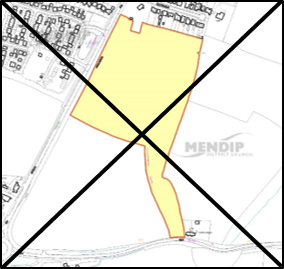
© Crown copyright and database rights 2021 Ordnance Survey 100019309.
Additional Information © Mendip District Council.
6 Wildlife and Countryside Act 1981 and s41 Natural Environment and Rural Communities Act 2006.
< Previous | ^ Top | Next >