
2.1 Harlow is located in the west of the County of Essex and is bordered by Epping Forest district to the south, west and east; and East Hertfordshire district (in the County of Hertfordshire) to the north (see Fig. 2.1).
2.2 Harlow is 38km north of London and 50km south of Cambridge. It has good access to the M11, and the West Anglia Mainline railway and Stansted Airport is located 24km to the north-east. Harlow is the smallest local authority area in Essex, with a land area of 30.5sqkm.
Fig. 2.1: Map of Harlow and its spatial setting
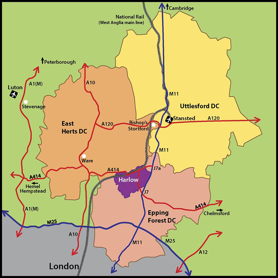
Contains OS data © Crown copyright and database right (2020). All rights reserved. Harlow District Council Licence No.100019627 (2020).
2.3 Between 1946 and 1970, 21 New Towns were designated in the UK under the New Towns Act, primarily to rehouse communities displaced by bomb damage caused during the Second World War. The New Towns were influenced by Garden Cities, formulated by Sir Ebenezer Howard in the late 1800s to deliver settlements which combined the best of town and country and offered alternatives to the polluted, industrial towns of the Industrial Revolution.
2.4 In September 1946, the then Minister of Town and Country Planning, Lewis Silkin, invited Frederick Gibberd to work on a plan for a New Town in the Harlow area. The plan would also contribute to designating the site of the New Town. An inquiry into the designation was held in December 1946 and the Ministry enacted a Designation Order for Harlow New Town on 25 March 1947. The current tight administrative boundary of Harlow, and subsequent small size of the district, is a legacy of this designation. However, Harlow nowadays serves as an important sub-regional centre that meets employment, retailing, social and cultural needs of the surrounding area.
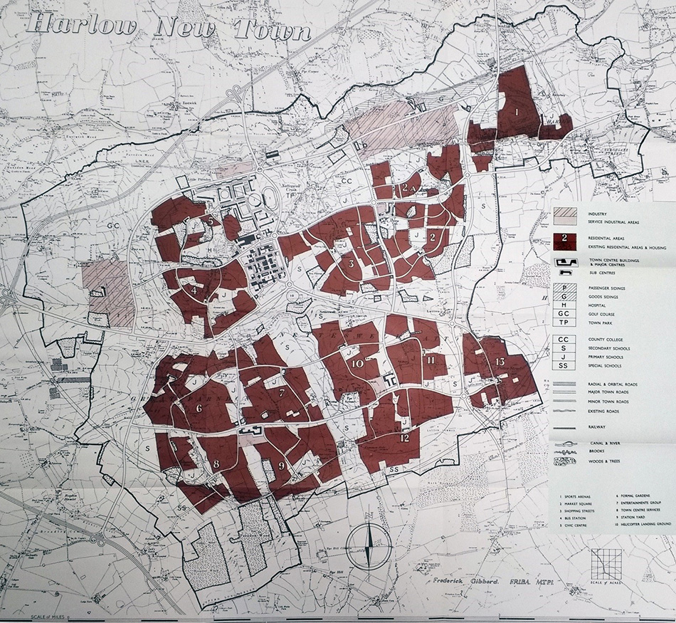
2.5 Sir Frederick Gibberd’s draft master plan was given ministerial approval in 1949 and the Harlow Development Corporation was established to deliver Harlow New Town. The final version of the master plan was published in 1952 (see Fig. 2.2).
2.6 The master plan was influenced by the area’s distinctive landscape and environmental features, such as the River Stort in the north, the valley ridges and wooded areas in the south and other important ecological assets. The New Town was built around a series of neighbourhoods, dissected by large areas of natural and semi-natural spaces, now known as Green Wedges, which are key physical features of Harlow that have shaped its subsequent growth.
2.7 The neighbourhoods, as set out in the master plan, were focussed around a shopping centre with easy access to social and educational facilities, connected by a series of distributor roads together with a network of cycleways and footpaths. These were separated by a network of landscape wedges, now known as Green Wedges, which were designed to reflect the original landscape setting.
2.8 The Green Wedges and Green Fingers continue to provide amenity space for residents, habitats for wildlife, transport corridors, locations for schools and sport and community facilities. Two industrial sites, Templefields and Pinnacles, were located in the north and west of the district, relatively close to the railway line. The Town Park was provided to the north-east of the town centre and was designed around existing landscape features and a hamlet.
Fig. 2.2: Harlow Master Plan (Harlow Development Corporation, 1952)
2.9 Harlow’s population is approximately 85,400 residents3 .The district first reached its original target population of around 80,000 people in the mid-1970s4 , but this was subsequently followed by a period of population decline. In 1995, Harlow’s population fell to 73,600 people3 , which gave rise to a number of social and economic problems.
2.10 The district’s population grew again in the late 1990s and 2000s through planned extensions to Harlow, in particular the Church Langley and Newhall neighbourhoods.
2.11 Harlow has a very high population density of 26.8 people per hectare, compared to 4.7 for Essex and 4.1 for England5 . This high density is compensated by easy access to services and facilities and the network of Green Wedges and open spaces across the district.
2.12 The population of Harlow, in comparison to the rest of Essex, is relatively young with 21% of its residents aged between 0-15 years, and the percentage of older persons living in Harlow is lower than Essex and England averages3. The district has a higher than average number of lone parent households6 and higher overcrowding levels compared to the rest of Essex and England7 . Smoking and obesity levels in Harlow are higher than average, with physical activity rates lower than average8 .
2.13 Deprivation levels in the district are overall lower than the England average but high compared to most parts of Essex9 . There are some variances between different parts of Harlow, with the east being less deprived than areas to the west and south. Furthermore, the district’s health profile is higher than the England averages in some respects, such as smoking rates, alcohol related hospital admissions and obesity. Physical activity is also low and therefore there are overall health and wellbeing issues across the town.
2.14 There are over 35,800 dwellings in the district and 34,700 households5. Harlow has a high proportion of homes rented from the Council, a legacy of the Development Corporation. There is also a higher than average proportion of terraced properties, which reflects the principles laid down in the original master plan for Harlow, where higher density urban areas were interspersed with areas of open space and linked green areas, including the Green Wedges.
2.15 Harlow’s property prices are lower than other parts of Essex. However the house price growth in Harlow has outstripped wage increases making properties in Harlow unaffordable for many of the district’s residents.
2.16 The highest level of affordable housing need in the Housing Market Area (HMA) is in East Hertfordshire (3,685 households) compared to 2,851 in Epping Forest, 3,098 in Harlow and 2,167 in Uttlesford10 . However, the percentage requirement in these districts compared with overall need is in stark contrast to Harlow, with 61% in Harlow compared with 35% in Epping Forest, 32% in East Hertfordshire and 26% in Uttlesford10. The need in Harlow equates to around 3,400 new affordable dwellings over the Local Plan period.
2.17 The Council has been working with selected partners to bring forward Regeneration projects. These projects are in the process of redeveloping some of the more outdated estates where it has become uneconomic to refurbish the original buildings, particularly where homes have been found to be structurally unsound. They also provide an opportunity to produce a net increase in the number of homes within the project area.
2.18 A limited number of new Council houses have been provided and a number of sites in Council ownership have been allocated where innovative housing schemes will be developed to further increase the supply of affordable homes.
2.19 Harlow has a slightly higher percentage of working age people (i.e. people aged 16-64 but not necessarily in work) than the East of England. The majority of Harlow’s jobs are engaged in health care and social work, mainly due to the presence of Princess Alexandra Hospital, wholesale and retail and administration and support service activities. The majority of Harlow residents are employed in elementary and sales and customer service occupations.
2.20 Residents of Harlow earn less than the county average and less than the average income of employees who work in Harlow11 . Given the high level of self-containment in Harlow, this would suggest that higher paid jobs are being filled by those living outside of Harlow, meaning the local economy misses out on their disposable income. The district’s residents also have a higher claimant count and lower qualification attainment compared to the rest of Essex and the rest of the country .
2.21 The district’s two main employment areas are located at Templefields in the north and the Pinnacles in the west. Templefields contains around 80,000sqm of commercial floorspace, mostly industrial and logistic, with relatively low levels of vacancy. The Council has designated 28ha of the Templefields employment area as part of Harlow’s Enterprise Zone in order to secure regeneration of the area.
2.22 The Pinnacles employment area consists of more high quality modern industrial units and mostly contains production, distribution and office uses. Vacancy rates are relatively low and the largest vacant building, the former GSK site, is to be occupied by Public Health England which is relocating to Harlow. It is considered that the new M11 Junction 7a will improve the flow of traffic east to west across the district and provide a catalyst for further growth.
2.23 The Council has also identified London Road, in the east of the district, as a further employment area of the Enterprise Zone. The purpose of this land is to promote medical technology and other high tech companies. It has also been identified as an opportunity site by the London Stansted Cambridge Consortium (LSCC).
2.24 As well as the two large employment areas and the Enterprise Zone sites, the district also has a number of smaller employment areas including Burnt Mill which mostly consists of warehousing and workshops; Staple Tye and Bush Fair Neighbourhood Centres which provide factory/office/workshop premises; and the Latton Bush Centre which provides a range of office floorspace.
2.25 Harlow Town Centre is a major employment and shopping destination with a mix of office, retail and leisure provision. It also provides an important supply of housing. In 2004, major regeneration took place through the development of the Water Gardens in the south which included the new Civic Centre, retail space including the Asda foodstore, and a 1,200 space car park. The Harvey Centre, an indoor shopping centre, also provides a number of retail units and has seen redevelopment through the provision of a new cinema and restaurants.
2.26 Broad Walk, a linear street running north-south along the eastern edge of the town centre, contains a number of retail units, although they are more constrained by size and configuration. The market is held at the northern end of Broad Walk. The northern end of the town centre around Market Square has a higher proportion of vacant units.
2.27 The district contains five Neighbourhood Centres and several smaller Hatches.
They provide important local retail and other facilities for residents and can help reduce car travel and increase sustainability. The five Neighbourhood Centres include Bush Fair and The Stow, both original 1950s centres which have seen little redevelopment or change; Old Harlow, which comprises the historic streets of the old market town; Church Langley, a modern hub serving the newer urban extension; and Staple Tye which saw major redevelopment in the 1980s to provide larger, more modern retail units.
2.28 Harlow benefits from being within close proximity of major transport corridors which afford good connectivity within the UK and beyond. This includes the M11 in the east which stretches from London to Cambridge and beyond towards Peterborough, and provides access to Stansted Airport which lies just north of Harlow; the A10 which lies further to the west which runs north-south from central London to Cambridge; the M25 ring-road Motorway around London; and the A414 which provides east-west routes from Chelmsford through to St Albans.
2.29 The district has two railway stations; Harlow Town and Harlow Mill located in the north and north-east of Harlow. They are located on the West Anglia Mainline which links London Liverpool Street to Cambridge. This line also provides an express train from Liverpool Street to Stansted Airport, stopping at Tottenham Hale, Cheshunt, Harlow Town, Bishop’s Stortford and Stansted Mountfitchet.
2.30 The internal road structure of Harlow reflects the original master plan of the district and is based on a network of primary distributor roads, mostly running through Green Wedges that link the main parts of Harlow with one another, and secondary distributor roads which link centres with each other and with the industrial estates. The primary distributor roads were originally intended to be dual carriageways and the secondary distributor roads were only intended to be single carriageway.
Both have become congested over time.
2.31 Cycleways and bridleways are aligned with the footpath system, including those running through Green Wedges and Green Fingers, and are extensive across the district. A number of locations in the highway network have dedicated bus lanes.
2.32 Harlow has only two major connections to the national road network: Junction 7 on the M11, which is the only link to the national motorway network; and the A414 at Burnt Mill which can become severely congested at peak periods. Junction 7 of the M11, the closest junction to Harlow, is at capacity; future planned growth including that already being proposed at the London Road Enterprise Zone is dependent upon changes to the strategic road network. The internal road structure has been subject to major modification to help relieve congestion including the provision of roundabouts to replace signalised junctions, on-off slip roads from those roundabouts and the conversion of single carriageways to dual carriageways. The new Junction 7a on the M11 to the north-east of the district will facilitate current and future development coming forward.
2.33 The Council has also supported the extension of Crossrail 2 to Harlow, to reinforce the key locational advantages of the district and to serve the growth identified across the wider Harlow area. The West Anglia Mainline is single tracked in both directions, but four-tracking has been under consideration for some time and would improve journey reliability and capacity. There is also a need to increase the frequency of the bus services to the industrial estates; to provide more opportunities to travel sustainably within and in and out of Harlow; to increase the provision of Sunday services; and to improve journey times for buses.
2.34 Improvements will be made to the local highway network and to the public transport network, including the enhancement of established transport corridors and the provision of new sustainable transport corridors through Harlow. This will help manage overall travel demand, improve connections within Harlow and to areas outside the district, and integrate new communities to Harlow, the Enterprise Zones and other employment areas through a choice of transport modes. There are also aspirations for a modal shift in travel, meaning 60% of travel in the new Garden Town Communities and 50% in the existing area of Harlow would be by sustainable modes of transport. Sustainable transport matters (including walking, cycling and public transport) and reducing the need to travel are, therefore, important for the successful future growth of Harlow.
2.35 Green Infrastructure is multi-functional natural and man-made urban and rural green space, including parks, playing fields, woodlands, allotments, wildlife corridors, rivers, canals and other bodies of water. Almost half of the land in Harlow is a form of open space, much of which is multi-functional, with 24% being designated as Green Wedges or Green Fingers, and 15% as Green Belt. These Green Wedges and Green Fingers are fundamental parts of the Green Infrastructure, as they contain multi-functional open spaces which are linked to other open spaces and the countryside.
2.36 The Green Belt, technically known as the Metropolitan Green Belt, was designated over sixty years ago to prevent the unrestricted sprawl of London and was expanded between the 1950s and 1980s. The land designated as Green Belt in Harlow forms part of this wider Green Belt.
2.37 Harlow contains a number of locally designated and nationally designated natural environment assets, including Sites of Special Scientific Interest and Local Wildlife Sites. In the north there is a series of floodplains and other wetland sites along the River Stort and Stort valley; centrally, from the Pinnacles area through to Newhall is a series of ancient woodlands and grasslands representing old countryside habitats; and in the south are the woodlands and commons of Parndon and Latton Bush areas.
2.38 As well as having important Green Infrastructure links and areas of important biodiversity and landscaping, Harlow also has a rich historical heritage even though most of the district was built post-war. Harlow has 10 Conservation Areas which protect some of the older areas of the district. These areas include Old Harlow, which was established before the New Town was built; and the Mark Hall neighbourhood, which reflects the early architectural style and planning of the New Town. The district also currently contains 168 listed buildings, 26 locally listed buildings, a Registered Park and Garden and several Scheduled Monuments.
2.39 Since its inception, Harlow has been subject to distinct phases of growth and change. The district still faces significant challenges, including a shortage of affordable housing and a range of good quality housing stock; a highway network which is severely congested at peak times; an ageing physical environment; localised deprivation; and a skills shortage. Harlow performs poorly against comparator towns on a range of measures including employment growth, Gross Value Added (GVA) per worker, knowledge based businesses, skills base and retail ranking. This, along with the district’s tight administrative boundaries, means that Harlow’s ability to meet its long-term needs are inhibited which can hinder the district’s regeneration and long-term economic prospects.
2.40 The Local Plan Evidence Base demonstrates that Harlow needs housing growth in order to improve and resolve the following issues to:
2.41 To provide affordable and flexible housing for future population needs
The Evidence Base shows that people are living longer and more live alone resulting in smaller households, increasing the need for homes irrespective of population growth. There will still be a requirement for Harlow to provide housing for future population needs and to resolve affordability and homelessness issues currently experienced in the district. Housing growth will also help to deliver a range of new quality homes in order to retain residents who may seek housing needs elsewhere and to attract new residents who will invest and work in the area.
2.42 To provide the critical mass needed to regenerate and reinforce retail centres
Additional housing means an increase in population resulting in increased spending in the district’s retail centres, particularly the town centre which provides sub-regional services and facilities. This spend will attract investors to locate in Harlow and, therefore, develop and regenerate the centres and reduce vacancy rates. Growth around the Neighbourhood Centres through estate regeneration will be delivered through the Local Plan. Growth in the Town Centre through the provision of new housing will be delivered through the separate Harlow Town Centre Area Action Plan. The aim is for Harlow to continue to be a sub-regional centre, competing with towns such as Bishop’s Stortford, the Brookfield Centre, Hertford, Stevenage and Chelmsford, by having an improved retail offer, new commercial leisure provision, an enhanced physical environment and more business space.
2.43 To provide the workforce for employers in order to retain and attract new businesses
Harlow needs to facilitate a successful, growing and attractive employment base serving both local and regional economies. To achieve this, Harlow will need to be an attractor for a wide range of businesses ranging from smaller local firms to larger multi-national companies. High quality housing must be attractive to prospective employers and employees. Additional housebuilding and related development will boost employment opportunities across a range of sectors that will support the local employment base.
2.44 To deliver major infrastructure
Major infrastructure enhancements are required to attract investors, businesses and therefore to improve economic aspirations in Harlow. Residential growth, located, managed and phased appropriately, will help to provide the investment needed to deliver infrastructure requirements including improvements to the walking and cycling network and public transport, the local and strategic road network and social infrastructure such as education and health, including the future requirements of the Princess Alexandra Hospital.
2.45 Significant behavioural change is required in the population of Harlow in order to deliver the enhancements needed to ensure Harlow is an attractive, sustainable and healthy town for residents, businesses and visitors.
3 Office for National Statistics, 2015 Mid-Year Estimates.
4 Gibberd, F., et al., 1980. HARLOW: The Story of a New Town.
5 Office for National Statistics, 2011 Census.
6 Office for National Statistics, 2015 Households and Families.
7 Office for National Statistics, 2011 Census Analysis.
8 Public Health England, 2015 Health Profile for Harlow.
9 Ministry for Housing, Communities and Local Government, 2015 English Indices of Deprivation.
10 ORS, West Essex and East Hertfordshire Strategic Housing Market Assessment Affordable Housing Update, July 2017.
11 Office for National Statistics, 2015. NOMIS Official Labour Market Statistics.
< Previous | ^ Top | Next >